
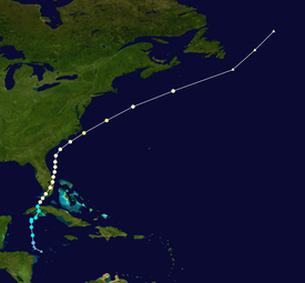
Alex coming soon.
Moderator: S2k Moderators


Nuno wrote:I am concerned about tomorrow being a regular work day with standard traffic and school still in session in SFL. I dont mean to criticize the NHC much but their approach to the "PTC" designation always seems a bit random and inconsistent. You don't need an LLC for a PTC, it was clear as of yesterday evening or this morning that something was going to come towards the peninsula. Like others and wxman have said, by time the center arrives Saturday most of the rain will be gone sheared to the east. Tomorrow is going to be an absolute slog and I really think designating the PTC sooner might have been more effective in transmitting such a public safety concern. I hope everyone is safe out on the roads tomorrow...


skyline385 wrote:Craters wrote:Nuno wrote:I am concerned about tomorrow being a regular work day with standard traffic and school still in session in SFL. I dont mean to criticize the NHC much but their approach to the "PTC" designation always seems a bit random and inconsistent. You don't need an LLC for a PTC, it was clear as of yesterday evening or this morning that something was going to come towards the peninsula. Like others and wxman have said, by time the center arrives Saturday most of the rain will be gone sheared to the east. Tomorrow is going to be an absolute slog and I really think designating the PTC sooner might have been more effective in transmitting such a public safety concern. I hope everyone is safe out on the roads tomorrow...
Nuno -- That's certainly a valid concern, but my guess is that most people get their weather info from local sources rather than directly from the NHC. If (IF!!!) the local radio and TV weather folks are doing their jobs concscientiously (I know, I know. . .), the fact that PTC 1 is headed toward SFL should be their Number One (Numero Uno, The Big Cheese, The Head Honcho) story, regardless of input from the NHC. In fact, if they'll be behaving anything like some of the [unnamed] local weather people in Houston, PTC 1 is going to be the spawn of Satan, coming so early in the season. I don't know what it's been like in SFL lately, but a tropical system headed that way should be prime hype material. I don't think that people will be unaware of the rain that's coming.
Just my more-or-less geezerish view of the situation.
Mark
There is not much hype here, not even close to something like the spawn of Satan. We were talking about it today in the office, most people were just mildly annoyed if anything because of the ruined weekend from the rainmaker. I have been in SFL for only 4 years but from what I have seen, people here dont care much about TS systems mostly because they are used to much worse.
beoumont wrote:skyline385 wrote:Craters wrote:
Nuno -- That's certainly a valid concern, but my guess is that most people get their weather info from local sources rather than directly from the NHC. If (IF!!!) the local radio and TV weather folks are doing their jobs concscientiously (I know, I know. . .), the fact that PTC 1 is headed toward SFL should be their Number One (Numero Uno, The Big Cheese, The Head Honcho) story, regardless of input from the NHC. In fact, if they'll be behaving anything like some of the [unnamed] local weather people in Houston, PTC 1 is going to be the spawn of Satan, coming so early in the season. I don't know what it's been like in SFL lately, but a tropical system headed that way should be prime hype material. I don't think that people will be unaware of the rain that's coming.
Just my more-or-less geezerish view of the situation.
Mark
There is not much hype here, not even close to something like the spawn of Satan. We were talking about it today in the office, most people were just mildly annoyed if anything because of the ruined weekend from the rainmaker. I have been in SFL for only 4 years but from what I have seen, people here dont care much about TS systems mostly because they are used to much worse.
As some sort of frame of reference to the above comments: In 1999, Hurricane Irene crossed S. Florida from the SSW, in October; with the advisories as it moved from just west of Homestead to just north of Ft. Lauderdale stating minimum pressure of 986 mb, with max sustained winds of 75 mph. Andy Dressler and myself first went to Homestead, then after the center passed just west of us, drove up the Palmetto Expressway and Turnpike, then east to Ft Lauderdale Beach. What was most strange is that despite hurricane warnings being in place and the "eye" almost on us, the traffic at 5 pm was just a little lighter, but still heavay, than typical 5 o'clock rush hour on those highways. Strange indeed. Most notable effect was the 20 inches of rain.


Hurricane Mike wrote:Looks to be tropical storm force winds. If a center is there, it's a tropical storm.


ChrisH-UK wrote:PTC One seems to look like a bit of a mess. On radar from NOAA, Mexico, Cuba and Belize the only low level circulation is in the Florida Straits.


eastcoastFL wrote:5am advisory not upgrading to Alex yet but changing the watches to warnings all around.
fci wrote:Nuno wrote:I am concerned about tomorrow being a regular work day with standard traffic and school still in session in SFL. I dont mean to criticize the NHC much but their approach to the "PTC" designation always seems a bit random and inconsistent. You don't need an LLC for a PTC, it was clear as of yesterday evening or this morning that something was going to come towards the peninsula. Like others and wxman have said, by time the center arrives Saturday most of the rain will be gone sheared to the east. Tomorrow is going to be an absolute slog and I really think designating the PTC sooner might have been more effective in transmitting such a public safety concern. I hope everyone is safe out on the roads tomorrow...
Not sure what you are worried about here.
Forecast is for a lot of rain with limited wind which is just an extended version of a typical summer rainy pattern day.
There are no preparations to be taken, no school closures and work isn't being cancelled.
I don't see a Public Safety concern since this will not be a Hurricane and a minimal Tropical Storm at worst.
Nuno wrote:fci wrote:Nuno wrote:I am concerned about tomorrow being a regular work day with standard traffic and school still in session in SFL. I dont mean to criticize the NHC much but their approach to the "PTC" designation always seems a bit random and inconsistent. You don't need an LLC for a PTC, it was clear as of yesterday evening or this morning that something was going to come towards the peninsula. Like others and wxman have said, by time the center arrives Saturday most of the rain will be gone sheared to the east. Tomorrow is going to be an absolute slog and I really think designating the PTC sooner might have been more effective in transmitting such a public safety concern. I hope everyone is safe out on the roads tomorrow...
Not sure what you are worried about here.
Forecast is for a lot of rain with limited wind which is just an extended version of a typical summer rainy pattern day.
There are no preparations to be taken, no school closures and work isn't being cancelled.
I don't see a Public Safety concern since this will not be a Hurricane and a minimal Tropical Storm at worst.
You don't see flash flood risks as a public safety concern? Just because this isn't a wind event doesn't mean that it is a "extended version of a typical summer" rainy day. Perhaps you end up being correct, I just want the messaging to get better since we have the tools for it. Water kills more than wind.
robbielyn wrote:Nuno wrote:I am concerned about tomorrow being a regular work day with standard traffic and school still in session in SFL. I dont mean to criticize the NHC much but their approach to the "PTC" designation always seems a bit random and inconsistent. You don't need an LLC for a PTC, it was clear as of yesterday evening or this morning that something was going to come towards the peninsula. Like others and wxman have said, by time the center arrives Saturday most of the rain will be gone sheared to the east. Tomorrow is going to be an absolute slog and I really think designating the PTC sooner might have been more effective in transmitting such a public safety concern. I hope everyone is safe out on the roads tomorrow...
Hopefully the local weathermen can really get across to their viewers what and when conditions will deteriorate and what to expect. Even TS designations are perceived as nothin to get excited about by most floridians. Usually only threat of hurricanes get peoples attention.
skyline385 wrote:Has to be TS Alex in next advisory
https://i.imgur.com/0dnlTzN.png https://i.imgur.com/rIXN50J.png
Users browsing this forum: No registered users and 8 guests

