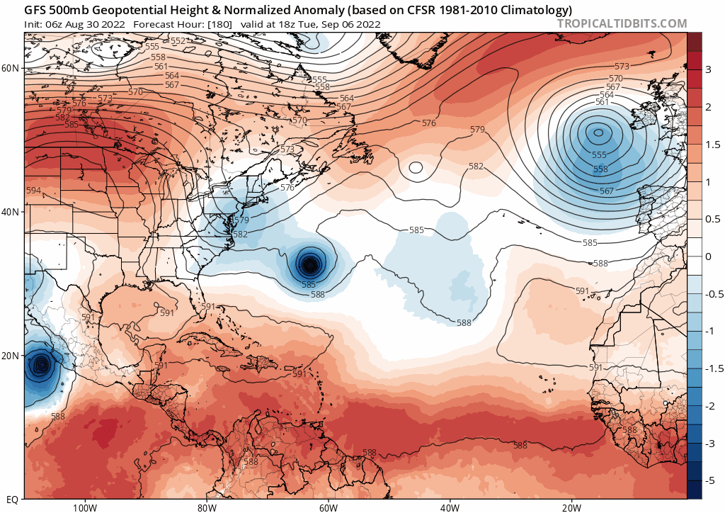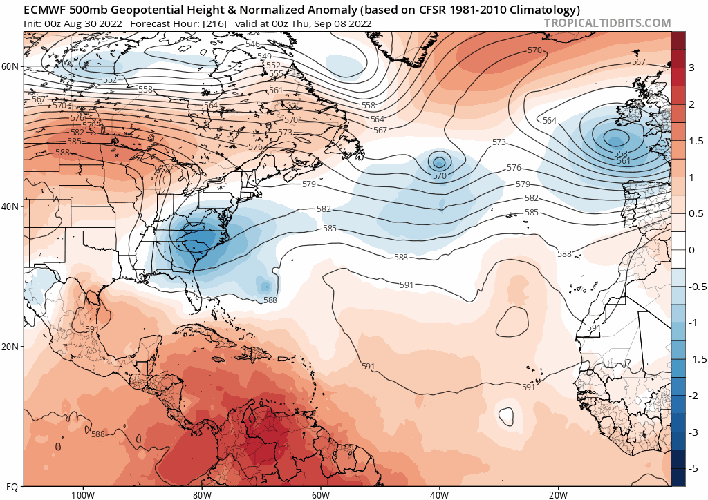
ATL: EARL - Models
Moderator: S2k Moderators
-
MHC Tracking
- Tropical Storm

- Posts: 203
- Joined: Mon Mar 15, 2021 10:05 am
-
SconnieCane
- Category 5

- Posts: 1013
- Joined: Thu Aug 02, 2018 5:29 pm
- Location: Madison, WI
Re: ATL: INVEST 91L - Models
ScottNAtlanta wrote:skyline385 wrote:0Z ICON now recurving at the end of its run as well
https://s6.gifyu.com/images/icon_mslp_pcpn_watl_fh120-180-1.gif
That looks like it is doing an anticyclonic loop
Jeanne 2004 has entered the chat.
1 likes
-
tolakram
- Admin

- Posts: 20176
- Age: 62
- Joined: Sun Aug 27, 2006 8:23 pm
- Location: Florence, KY (name is Mark)
Re: ATL: INVEST 91L - Models
0Z Euro run

Trivia question: How many upper level lows were around Dorian?

Trivia question: How many upper level lows were around Dorian?
0 likes
M a r k
- - - - -
Join us in chat: Storm2K Chatroom Invite. Android and IOS apps also available.
The posts in this forum are NOT official forecasts and should not be used as such. Posts are NOT endorsed by any professional institution or STORM2K.org. For official information and forecasts, please refer to NHC and NWS products.
- Blown Away
- S2K Supporter

- Posts: 10253
- Joined: Wed May 26, 2004 6:17 am
Re: ATL: INVEST 91L - Models


06z ECMWF... Subtle recent W shifts, and Ukmet shifted W. It happens I know, but sharp NE turn @27N seems extreme for Aug/Early Sept. The 12z BAMD may be a hint?
1 likes
Hurricane Eye Experience: David 79, Irene 99, Frances 04, Jeanne 04, Wilma 05… Hurricane Brush Experience: Andrew 92, Erin 95, Floyd 99, Matthew 16, Irma 17, Ian 22, Nicole 22…
Re: ATL: INVEST 91L - Models
Blown Away wrote:https://i.imgur.com/thwWmOj.jpg
https://i.imgur.com/xx32W7z.gif
06z ECMWF... Subtle recent W shifts, and Ukmet shifted W. It happens I know, but sharp NE turn @27N seems extreme for Aug/Early Sept. The 12z BAMD may be a hint?
Not really related but look up at 40N on that run. Something might try to snatch the name Danielle from 91L.
0 likes
Irene '11 Sandy '12 Hermine '16 5/15/2018 Derecho Fay '20 Isaias '20 Elsa '21 Henri '21 Ida '21
I am only a meteorology enthusiast who knows a decent amount about tropical cyclones. Look to the professional mets, the NHC, or your local weather office for the best information.
I am only a meteorology enthusiast who knows a decent amount about tropical cyclones. Look to the professional mets, the NHC, or your local weather office for the best information.
- SFLcane
- S2K Supporter

- Posts: 10281
- Age: 48
- Joined: Sat Jun 05, 2010 1:44 pm
- Location: Lake Worth Florida
Re: ATL: INVEST 91L - Models
Blown Away wrote:https://i.imgur.com/thwWmOj.jpg
https://i.imgur.com/xx32W7z.gif
06z ECMWF... Subtle recent W shifts, and Ukmet shifted W. It happens I know, but sharp NE turn @27N seems extreme for Aug/Early Sept. The 12z BAMD may be a hint?
More then likely will not get passed 70w before turning north. Bermuda should keep an eye out.


0 likes
- ScottNAtlanta
- Category 5

- Posts: 2535
- Joined: Sat May 25, 2013 3:11 pm
- Location: Atlanta, GA
Re: ATL: INVEST 91L - Models
Blown Away wrote:https://i.imgur.com/thwWmOj.jpg
https://i.imgur.com/xx32W7z.gif
06z ECMWF... Subtle recent W shifts, and Ukmet shifted W. It happens I know, but sharp NE turn @27N seems extreme for Aug/Early Sept. The 12z BAMD may be a hint?
The model seems to be consolidating it more toward the middle initializing it more south than before
0 likes
The posts in this forum are NOT official forecast and should not be used as such. They are just the opinion of the poster and may or may not be backed by sound meteorological data. They are NOT endorsed by any professional institution or storm2k.org. For official information, please refer to the NHC and NWS products.
- Hypercane_Kyle
- Category 5

- Posts: 3465
- Joined: Sat Mar 07, 2015 7:58 pm
- Location: Cape Canaveral, FL
Re: ATL: INVEST 91L - Models
Looks like your classic recurving hurricane to me. Euro is likely wrong as ever, far too weak 5+ days out. Bermuda may have to watch out for this one.
0 likes
My posts are my own personal opinion, defer to the National Hurricane Center (NHC) and other NOAA products for decision making during hurricane season.
Re: ATL: INVEST 91L - Models
12z gfs similar to 6z track wise out to 138 hours, but a good bit slower.
0 likes
Re: ATL: INVEST 91L - Models
UK 12z still a far outlier to the left, much further SW than all other models, near Turks & Caicos at 144 hrs
0 likes
- Blown Away
- S2K Supporter

- Posts: 10253
- Joined: Wed May 26, 2004 6:17 am
Re: ATL: INVEST 91L - Models

12z CMC... Decent shift W, moves just above PR and almost to Central Bahamas before making extreme NE turn over Bermuda...
2 likes
Hurricane Eye Experience: David 79, Irene 99, Frances 04, Jeanne 04, Wilma 05… Hurricane Brush Experience: Andrew 92, Erin 95, Floyd 99, Matthew 16, Irma 17, Ian 22, Nicole 22…
Re: ATL: INVEST 91L - Models
Man, that's some incredible acceleration eastward after the turn!
0 likes
I'm not a meteorologist, I'm an electronics engineer. While I can probably fix your toaster oven, you're not going to learn about storms from me!
New Mexico had no hurricanes. Then I moved to NC right before Fran.....
New Mexico had no hurricanes. Then I moved to NC right before Fran.....
Re: ATL: INVEST 91L - Models
12Z GFS never gets west of -65 and the rest of the models are recurving Bermuda is at longitude -65 west. Looks like it will be a strong storm, if it exited out to sea a little slower it might leave a weakness for a couple September storms to follow.
1 likes
-
tolakram
- Admin

- Posts: 20176
- Age: 62
- Joined: Sun Aug 27, 2006 8:23 pm
- Location: Florence, KY (name is Mark)
Re: ATL: INVEST 91L - Models
0 likes
M a r k
- - - - -
Join us in chat: Storm2K Chatroom Invite. Android and IOS apps also available.
The posts in this forum are NOT official forecasts and should not be used as such. Posts are NOT endorsed by any professional institution or STORM2K.org. For official information and forecasts, please refer to NHC and NWS products.
- - - - -
Join us in chat: Storm2K Chatroom Invite. Android and IOS apps also available.
The posts in this forum are NOT official forecasts and should not be used as such. Posts are NOT endorsed by any professional institution or STORM2K.org. For official information and forecasts, please refer to NHC and NWS products.
- Europa non è lontana
- Tropical Storm

- Posts: 116
- Joined: Wed Nov 11, 2020 10:01 pm
Re: ATL: INVEST 91L - Models
Last edited by Europa non è lontana on Tue Aug 30, 2022 1:40 pm, edited 1 time in total.
0 likes
Re: ATL: INVEST 91L - Models
sma10 wrote:UK 12z still a far outlier to the left, much further SW than all other models, near Turks & Caicos at 144 hrs
Yeah, the 12Z UKMET is actually a bit SW of its 0Z position as of hour 96, when it is at 19.3N, 62.4W. This compares to the 0Z UKMET at 108, when it was 20.4N, 61.6W.
Then the 12Z UKMET at hour 108 "ceases tracking" it as a TC:
TROPICAL DEPRESSION 91L ANALYSED POSITION : 14.8N 48.3W
ATCF IDENTIFIER : AL912022
LEAD CENTRAL MAXIMUM WIND
VERIFYING TIME TIME POSITION PRESSURE (MB) SPEED (KNOTS)
-------------- ---- -------- ------------- -------------
1200UTC 30.08.2022 0 14.8N 48.3W 1009 25
0000UTC 31.08.2022 12 15.6N 49.4W 1009 24
1200UTC 31.08.2022 24 15.8N 50.6W 1008 26
0000UTC 01.09.2022 36 16.3N 51.8W 1008 25
1200UTC 01.09.2022 48 17.5N 53.9W 1007 27
0000UTC 02.09.2022 60 18.0N 55.8W 1007 28
1200UTC 02.09.2022 72 18.9N 57.9W 1007 31
0000UTC 03.09.2022 84 19.1N 60.5W 1008 31
1200UTC 03.09.2022 96 19.3N 62.4W 1009 29
0000UTC 04.09.2022 108 CEASED TRACKING
Then, it brings it back at hour 138 as a "New tropical cyclone" when it has it at 21.0N, 70.1W, moving WNW, which is quite a bit WSW of the 0Z run's position for then:
NEW TROPICAL CYCLONE FORECAST TO DEVELOP AFTER 138 HOURS
FORECAST POSITION AT T+138 : 21.0N 70.1W
LEAD CENTRAL MAXIMUM WIND
VERIFYING TIME TIME POSITION PRESSURE (MB) SPEED (KNOTS)
-------------- ---- -------- ------------- -------------
1200UTC 05.09.2022 144 21.6N 71.3W 1010 24
1 likes
Personal Forecast Disclaimer:
The posts in this forum are NOT official forecasts and should not be used as such. They are just the opinion of the poster and may or may not be backed by sound meteorological data. They are NOT endorsed by any professional institution or storm2k.org. For official information, please refer to the NHC and NWS products.
The posts in this forum are NOT official forecasts and should not be used as such. They are just the opinion of the poster and may or may not be backed by sound meteorological data. They are NOT endorsed by any professional institution or storm2k.org. For official information, please refer to the NHC and NWS products.
- Kingarabian
- S2K Supporter

- Posts: 16342
- Joined: Sat Aug 08, 2009 3:06 am
- Location: Honolulu, Hawaii
-
tolakram
- Admin

- Posts: 20176
- Age: 62
- Joined: Sun Aug 27, 2006 8:23 pm
- Location: Florence, KY (name is Mark)
Re: ATL: INVEST 91L - Models
Weak and stalled. Will it go west if it stays weak?


0 likes
M a r k
- - - - -
Join us in chat: Storm2K Chatroom Invite. Android and IOS apps also available.
The posts in this forum are NOT official forecasts and should not be used as such. Posts are NOT endorsed by any professional institution or STORM2K.org. For official information and forecasts, please refer to NHC and NWS products.
- - - - -
Join us in chat: Storm2K Chatroom Invite. Android and IOS apps also available.
The posts in this forum are NOT official forecasts and should not be used as such. Posts are NOT endorsed by any professional institution or STORM2K.org. For official information and forecasts, please refer to NHC and NWS products.
- Blown Away
- S2K Supporter

- Posts: 10253
- Joined: Wed May 26, 2004 6:17 am
Re: ATL: INVEST 91L - Models

12z Euro... Stalls and loops just E of Bahamas through 198... Very weak
0 likes
Hurricane Eye Experience: David 79, Irene 99, Frances 04, Jeanne 04, Wilma 05… Hurricane Brush Experience: Andrew 92, Erin 95, Floyd 99, Matthew 16, Irma 17, Ian 22, Nicole 22…
Who is online
Users browsing this forum: No registered users and 8 guests


