Well, the good news is that the Euro and GFS finally have something of a consensus.
The bad news is that consensus is so close to the Tampa coastline that a 5-10 mile deviation east over the next 72 hours will literally make the difference between potentially major hurricane conditions and a breezy, very rainy day.
ATL: IAN - Models
Moderator: S2k Moderators
-
Hypercane_Kyle

- Category 5

- Posts: 3465
- Joined: Sat Mar 07, 2015 7:58 pm
- Location: Cape Canaveral, FL
Re: ATL: IAN - Models
2 likes
My posts are my own personal opinion, defer to the National Hurricane Center (NHC) and other NOAA products for decision making during hurricane season.

Re: ATL: IAN - Models
The 18z global and hurricane model runs show a landfall in western Cuba, no further east than Isla de la Juventud, between 06z and 09z Tuesday morning. That gives Ian another 30-36 hours over water, although tracks on the eastern side of the guidance could result in earlier land interaction with Juventud.
2 likes
Irene '11 Sandy '12 Hermine '16 5/15/2018 Derecho Fay '20 Isaias '20 Elsa '21 Henri '21 Ida '21
I am only a meteorology enthusiast who knows a decent amount about tropical cyclones. Look to the professional mets, the NHC, or your local weather office for the best information.
I am only a meteorology enthusiast who knows a decent amount about tropical cyclones. Look to the professional mets, the NHC, or your local weather office for the best information.

Re: ATL: IAN - Models
skyline385 wrote:18Z EPS mean makes a landfall near Tampa Bay
Looks like the mean actually landfalls near bradenton-sarasota area.
1 likes

Re: ATL: IAN - Models
I’m looking at these members and I’m thinking… they are all going to be wrong on pressure pre Cuba. Hardly any red members before Cuba… Ian’s got to be able to make it lower than that right?
Last edited by StAuggy on Sun Sep 25, 2022 8:58 pm, edited 1 time in total.
3 likes
Re: ATL: IAN - Models
Hypercane_Kyle wrote:Well, the good news is that the Euro and GFS finally have something of a consensus.
The bad news is that consensus is so close to the Tampa coastline that a 5-10 mile deviation east over the next 72 hours will literally make the difference between potentially major hurricane conditions and a breezy, very rainy day.
I would paraphrase it as the difference between major hurricane conditions with 10 ft of surge vs without.
4 likes
Re: ATL: IAN - Models
The 18Z UKMET at 60 is 40 miles ESE of the 12Z at 66.
1 likes
Personal Forecast Disclaimer:
The posts in this forum are NOT official forecasts and should not be used as such. They are just the opinion of the poster and may or may not be backed by sound meteorological data. They are NOT endorsed by any professional institution or storm2k.org. For official information, please refer to the NHC and NWS products.
The posts in this forum are NOT official forecasts and should not be used as such. They are just the opinion of the poster and may or may not be backed by sound meteorological data. They are NOT endorsed by any professional institution or storm2k.org. For official information, please refer to the NHC and NWS products.
-
gatorcane

- S2K Supporter

- Posts: 23708
- Age: 48
- Joined: Sun Mar 13, 2005 3:54 pm
- Location: Boca Raton, FL
Re: ATL: IAN - Models
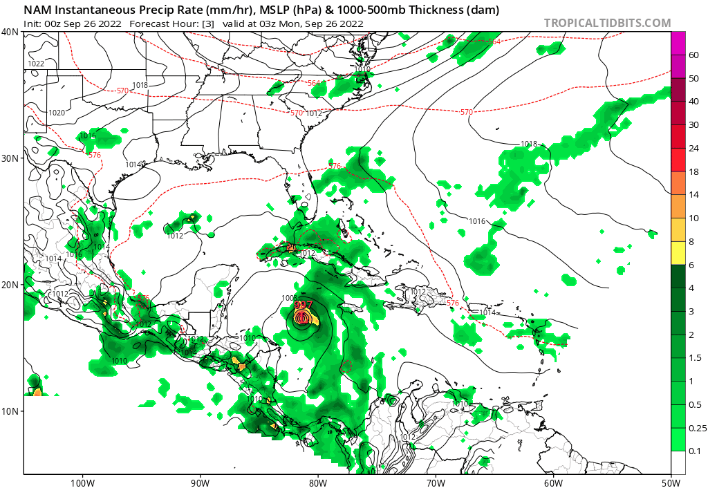
00Z NAM much stronger and east shift at 51 hours approaching SW coast of Florida.
Last edited by gatorcane on Sun Sep 25, 2022 9:45 pm, edited 1 time in total.
1 likes
-
skillz305
- Category 1

- Posts: 312
- Joined: Sat Sep 08, 2018 11:10 am
- Location: Miami, Florida --> Vero Beach, Florida
Re: ATL: IAN - Models
LarryWx wrote:The 18Z UKMET at 60 is 40 miles ESE of the 12Z at 66.
Oh wow. Any visuals to that run?
1 likes
 Hurricanes: Andrew 1992 - Irene 1999 - Frances 2004 - Jeanne 2004 - Katrina 2005 - Wilma 2005 - Matthew 2016 - Irma 2017 - Ian 2022 - Nicole 2022 - Milton 2024
Re: ATL: IAN - Models
gatorcane wrote:00Z NAM much stronger and east shift at 51 hours approaching SW coast of Florida.
https://i.postimg.cc/Gm3wDQrY/nam-mslp-pcpn-watl-fh3-51.gif
Windshield wiping or honing in? My gut senses the latter
1 likes
Andy D
(For official information, please refer to the NHC and NWS products.)
(For official information, please refer to the NHC and NWS products.)
-
StPeteMike

- Category 2

- Posts: 655
- Joined: Thu Jun 07, 2018 11:26 pm
Re: ATL: IAN - Models
NAM initialized already weaker than what it currently is at. Still think Ian passes Isle of Youth to the west.
1 likes
The above post is not official and should not be used as such. It is the opinion of the poster and may or may not be backed by sound meteorological data. It is not endorsed by any professional institution or storm2k.org. For official information, please refer to the NHC and NWS products.
-
skyline385

- Category 5
- Posts: 2728
- Age: 35
- Joined: Wed Aug 26, 2020 11:15 pm
- Location: Houston TX
Re: ATL: IAN - Models
skillz305 wrote:LarryWx wrote:The 18Z UKMET at 60 is 40 miles ESE of the 12Z at 66.
Oh wow. Any visuals to that run?
Here is UKMET 12Z vs 12Z landfall vs18Z since the 06/18Z runs only go up to 60 hours

Last edited by skyline385 on Sun Sep 25, 2022 9:59 pm, edited 2 times in total.
1 likes
Re: ATL: IAN - Models
Icons started about 10 to 12 mbar weaker than it actually is right now, not sure how that will affect the run though.
3 likes
Re: ATL: IAN - Models
If Ian Does decide to pay Tampa visit, we really have to hope that it had just south of Tampa rather than just north of it, At least then the storm surge would be lessened.
5 likes
-
skyline385
- Category 5
- Posts: 2728
- Age: 35
- Joined: Wed Aug 26, 2020 11:15 pm
- Location: Houston TX

Re: ATL: IAN - Models
0z Icon virtually no change in landfall point (Venice), but 6mb stronger in the 0z. Then rides (well slow walks since it takes nearly 24 hours) up I-4 to exit near New Smyrna Beach. Then another landfall in Edisto Beach, SC.

Last edited by BobHarlem on Sun Sep 25, 2022 10:31 pm, edited 2 times in total.
1 likes
-
Texas Snowman

- Storm2k Moderator

- Posts: 6197
- Joined: Fri Jan 25, 2008 11:29 am
- Location: Denison, Texas
Re: ATL: IAN - Models
Potential is there for a stressful few days and we’ll have a lot of guests checking in, so let’s remember our rules and let’s stay on topic.
Texas Snowman
6 likes
The above post and any post by Texas Snowman is NOT an official forecast and should not be used as such. It is just the opinion of the poster and may or may not be backed by sound meteorological data. It is NOT endorsed by any professional institution including storm2k.org. For official information, please refer to NWS products.
Re: ATL: IAN - Models
GFS is pretty much the same strength as the previous run but a tiny tiny bit to the left so far.
1 likes

Re: ATL: IAN - Models
Fancy1001 wrote:Icons started about 10 to 12 mbar weaker than it actually is right now, not sure how that will affect the run though.
A stronger Ian south of Cuba will likely pump up the high pressure dome it is developing under.
That would help the trough depart a little sooner.
NHC probably factored that in since they didn't call for a landfall Tampa bay south.
I still think Ian has a fair chance of reaching -85W if the dome starts to build early.
1 likes
-
eastcoastFL

- Category 5
- Posts: 3996
- Age: 44
- Joined: Thu Apr 12, 2007 12:29 pm
- Location: Palm City, FL
Re: ATL: IAN - Models
GFS 48H

1 likes
Personal Forecast Disclaimer:
The posts in this forum are NOT official forecast and should not be used as such. They are just the opinion of the poster and may or may not be backed by sound meteorological data. They are NOT endorsed by any professional institution or storm2k.org. For official information, please refer to the NHC and NWS products.
The posts in this forum are NOT official forecast and should not be used as such. They are just the opinion of the poster and may or may not be backed by sound meteorological data. They are NOT endorsed by any professional institution or storm2k.org. For official information, please refer to the NHC and NWS products.
Who is online
Users browsing this forum: No registered users and 39 guests