ATL: IAN - Post-Tropical - Discussion

Moderator: S2k Moderators

Message
Author
CrazyC83
Professional-Met
Professional-Met
Posts: 34002
Joined: Tue Mar 07, 2006 11:57 pm
Location: Deep South, for the first time!

Re: ATL: IAN - Hurricane - Discussion

#2821 Postby CrazyC83 » Mon Sep 26, 2022 11:09 pm

Hypercane_Kyle wrote:I'd go with 95 knots, MSLP 959 mb based on that last pass. I'd like to see flight level winds up a bit before going with MH but should be one in short order.


Same here. In the absence of additional data, I'd set it at 95 kt for the 2 am advisory.
2 likes   

wx98
Category 5
Category 5
Posts: 1383
Joined: Sat Aug 25, 2018 9:24 pm

Re: ATL: IAN - Hurricane - Discussion

#2822 Postby wx98 » Mon Sep 26, 2022 11:09 pm

That pass supports 110 mph/960 mbar. You could make a case to upgrade to Cat 3 though, since technically it starts at 111 mph.
1 likes   

bob rulz
Category 5
Category 5
Posts: 1704
Age: 35
Joined: Sat Jan 28, 2006 7:30 pm
Location: Salt Lake City, Utah

Re: ATL: IAN - Hurricane - Discussion

#2823 Postby bob rulz » Mon Sep 26, 2022 11:10 pm

Coolcruiseman wrote:The "tropical storm conditions possible" for Thursday has now updated by the local NWS office to "Hurricane conditions possible" here.

Guess it could get interesting here on the Space Coast.


Good thing they rolled SLS back.
4 likes   

User avatar
TheDreamTraveler
Category 2
Category 2
Posts: 641
Joined: Sun Aug 22, 2010 3:10 am
Location: PA

Re: ATL: IAN - Hurricane - Discussion

#2824 Postby TheDreamTraveler » Mon Sep 26, 2022 11:11 pm


It's still mind blowing to me that the biggest surge ever recorded in the Tampa Bay was 4 feet during the Storm of the Century in 1993. And yet Ian's forecast surge is going to be 6-10 feet at least. This just shows you how rare powerful major hurricane strikes like this are on this part of the west coast of Florida
1 likes   

User avatar
cheezyWXguy
Category 5
Category 5
Posts: 6108
Joined: Mon Feb 13, 2006 12:29 am
Location: Dallas, TX

Re: ATL: IAN - Hurricane - Discussion

#2825 Postby cheezyWXguy » Mon Sep 26, 2022 11:11 pm

GeneratorPower wrote:
cheezyWXguy wrote:Should note the eye we’re seeing on IR is only the eastern half. The western half is still underneath convection, so that probably accounts for the discrepancy we’re seeing between IR and radar

Just use Key West radar. It’s in range.

Agreed, that’s what I used to see that there was a discrepancy
1 likes   

User avatar
FLpanhandle91
Category 5
Category 5
Posts: 1033
Age: 34
Joined: Mon Sep 13, 2010 3:50 pm
Location: Fort Walton Beach, FL

Re: ATL: IAN - Hurricane - Discussion

#2826 Postby FLpanhandle91 » Mon Sep 26, 2022 11:14 pm

Ian is currently 10-20mb stronger than almost every single model not named HWRF forecasted it to be at this point.
3 likes   

Hurricane Mike
Category 2
Category 2
Posts: 644
Joined: Tue Apr 10, 2018 7:44 am

Re: ATL: IAN - Hurricane - Discussion

#2827 Postby Hurricane Mike » Mon Sep 26, 2022 11:14 pm

Looking more and more like Ian will come ashore as a major.
2 likes   

wx98
Category 5
Category 5
Posts: 1383
Joined: Sat Aug 25, 2018 9:24 pm

Re: ATL: IAN - Hurricane - Discussion

#2828 Postby wx98 » Mon Sep 26, 2022 11:14 pm

If it continues NNW it’s about 45 miles from landfall. That part of Cuba is roughly 50 miles N to S, so it’s probably about 8-10 hours from emerging into the Gulf.
1 likes   

tolakram
Admin
Admin
Posts: 20012
Age: 62
Joined: Sun Aug 27, 2006 8:23 pm
Location: Florence, KY (name is Mark)

Re: ATL: IAN - Hurricane - Discussion

#2829 Postby tolakram » Mon Sep 26, 2022 11:15 pm

Image
4 likes   
M a r k
- - - - -
Join us in chat: Storm2K Chatroom Invite. Android and IOS apps also available.

The posts in this forum are NOT official forecasts and should not be used as such. Posts are NOT endorsed by any professional institution or STORM2K.org. For official information and forecasts, please refer to NHC and NWS products.

User avatar
eastcoastFL
Category 5
Category 5
Posts: 3901
Age: 43
Joined: Thu Apr 12, 2007 12:29 pm
Location: Palm City, FL

Re: ATL: IAN - Hurricane - Discussion

#2830 Postby eastcoastFL » Mon Sep 26, 2022 11:16 pm

TheDreamTraveler wrote:


It's still mind blowing to me that the biggest surge ever recorded in the Tampa Bay was 4 feet during the Storm of the Century in 1993. And yet Ian's forecast surge is going to be 6-10 feet at least. This just shows you how rare powerful major hurricane strikes like this are on this part of the west coast of Florida


If the GFS is right they could see nearly 4 feet of rain.
5 likes   
Personal Forecast Disclaimer:
The posts in this forum are NOT official forecast and should not be used as such. They are just the opinion of the poster and may or may not be backed by sound meteorological data. They are NOT endorsed by any professional institution or storm2k.org. For official information, please refer to the NHC and NWS products.

tolakram
Admin
Admin
Posts: 20012
Age: 62
Joined: Sun Aug 27, 2006 8:23 pm
Location: Florence, KY (name is Mark)

Re: ATL: IAN - Hurricane - Discussion

#2831 Postby tolakram » Mon Sep 26, 2022 11:18 pm

Image
10 likes   
M a r k
- - - - -
Join us in chat: Storm2K Chatroom Invite. Android and IOS apps also available.

The posts in this forum are NOT official forecasts and should not be used as such. Posts are NOT endorsed by any professional institution or STORM2K.org. For official information and forecasts, please refer to NHC and NWS products.

psyclone
S2K Supporter
S2K Supporter
Posts: 4769
Joined: Wed Aug 24, 2005 9:04 pm
Location: palm harbor fl

Re: ATL: IAN - Hurricane - Discussion

#2832 Postby psyclone » Mon Sep 26, 2022 11:18 pm

TheDreamTraveler wrote:


It's still mind blowing to me that the biggest surge ever recorded in the Tampa Bay was 4 feet during the Storm of the Century in 1993. And yet Ian's forecast surge is going to be 6-10 feet at least. This just shows you how rare powerful major hurricane strikes like this are on this part of the west coast of Florida

Low hurricane frequency was a factor in my decision to relocate here. having said that...going a century without a major is a remarkable luck streak. there's too many storms recurving from down south to not expect a biggie every 30 years or so.
4 likes   

User avatar
Teban54
Category 5
Category 5
Posts: 3208
Joined: Sat May 19, 2018 1:19 pm

Re: ATL: IAN - Hurricane - Discussion

#2833 Postby Teban54 » Mon Sep 26, 2022 11:18 pm

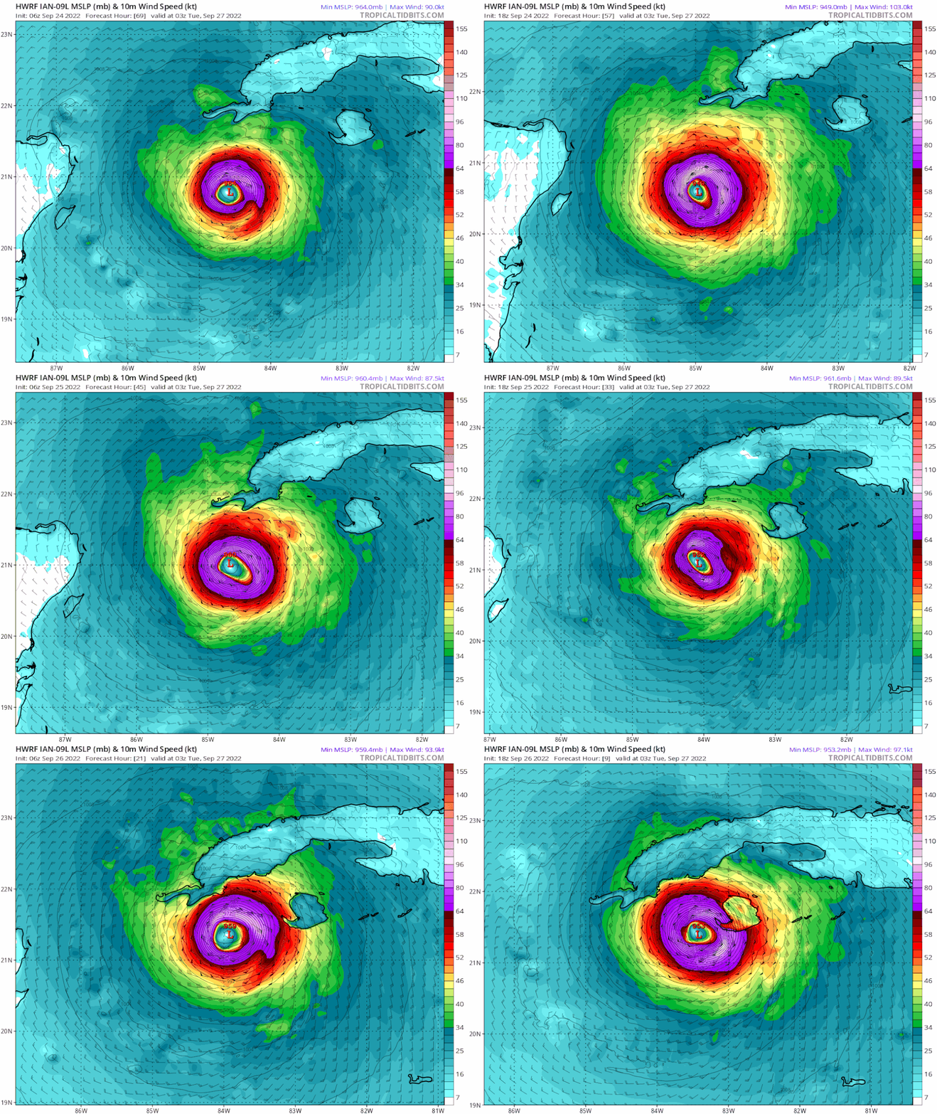
FLpanhandle91 wrote:Ian is currently 10-20mb stronger than almost every single model not named HWRF forecasted it to be at this point.

For the past 3 days, HWRF consistently predicted its current intensity to be in the 950s or 960s, barring a few earlier runs.

Actual intensity right now (as per extrap): 959.6 mb. Wind likely 95 kt or 100 kt.

Looks like Ian is precisely on track.
Image
3 likes   

User avatar
NDG
S2K Supporter
S2K Supporter
Posts: 15446
Joined: Sun Jul 09, 2006 10:14 pm
Location: Orlando, FL

Re: ATL: IAN - Hurricane - Discussion

#2834 Postby NDG » Mon Sep 26, 2022 11:20 pm

Image
12 likes   

Knight85
Tropical Wave
Tropical Wave
Posts: 9
Joined: Fri Sep 23, 2022 2:59 pm
Location: Safety Harbor, FL

Re: ATL: IAN - Hurricane - Discussion

#2835 Postby Knight85 » Mon Sep 26, 2022 11:21 pm

eastcoastFL wrote:
TheDreamTraveler wrote:


It's still mind blowing to me that the biggest surge ever recorded in the Tampa Bay was 4 feet during the Storm of the Century in 1993. And yet Ian's forecast surge is going to be 6-10 feet at least. This just shows you how rare powerful major hurricane strikes like this are on this part of the west coast of Florida


If the GFS is right they could see nearly 4 feet of rain.


The ground in the Tampa Bay area is waterlogged as it is. Driving along Bayshore in Safety Harbor, the drainage ditches are nearly topped already.
4 likes   

User avatar
Kazmit
Category 5
Category 5
Posts: 2124
Age: 22
Joined: Mon Jul 25, 2016 8:49 am
Location: Williamsburg, VA / Bermuda

Re: ATL: IAN - Hurricane - Discussion

#2836 Postby Kazmit » Mon Sep 26, 2022 11:23 pm

Teban54 wrote:
FLpanhandle91 wrote:Ian is currently 10-20mb stronger than almost every single model not named HWRF forecasted it to be at this point.

For the past 3 days, HWRF consistently predicted its current intensity to be in the 950s or 960s, barring a few earlier runs.

Actual intensity right now (as per extrap): 959.6 mb. Wind likely 95 kt or 100 kt.
Looks like Ian is precisely on track.
https://i.postimg.cc/j2gctfwn/hwrf-mslp-wind-09-L-fh9-trend.gif

HWRF nails it a lot of the time.
3 likes   
Igor 2010, Sandy 2012, Fay 2014, Gonzalo 2014, Joaquin 2015, Nicole 2016, Humberto 2019

I am only a tropical weather enthusiast. My predictions are not official and may or may not be backed by sound meteorological data. For official information, please refer to the NHC and NWS products.

User avatar
eastcoastFL
Category 5
Category 5
Posts: 3901
Age: 43
Joined: Thu Apr 12, 2007 12:29 pm
Location: Palm City, FL

Re: ATL: IAN - Hurricane - Discussion

#2837 Postby eastcoastFL » Mon Sep 26, 2022 11:25 pm

Knight85 wrote:
eastcoastFL wrote:
TheDreamTraveler wrote:
It's still mind blowing to me that the biggest surge ever recorded in the Tampa Bay was 4 feet during the Storm of the Century in 1993. And yet Ian's forecast surge is going to be 6-10 feet at least. This just shows you how rare powerful major hurricane strikes like this are on this part of the west coast of Florida


If the GFS is right they could see nearly 4 feet of rain.


The ground in the Tampa Bay area is waterlogged as it is. Driving along Bayshore in Safety Harbor, the drainage ditches are nearly topped already.


This is an ugly set up all around for tampa area. I hope people are listening to the evacuation orders. One thing I like to stress is even if you get lucky and your home is fine you're still stuck. No power and roads are impassable for who knows how long. It's just not worth it to stay if you're in an evacuation area.
4 likes   
Personal Forecast Disclaimer:
The posts in this forum are NOT official forecast and should not be used as such. They are just the opinion of the poster and may or may not be backed by sound meteorological data. They are NOT endorsed by any professional institution or storm2k.org. For official information, please refer to the NHC and NWS products.

Hurricane Mike
Category 2
Category 2
Posts: 644
Joined: Tue Apr 10, 2018 7:44 am

Re: ATL: IAN - Hurricane - Discussion

#2838 Postby Hurricane Mike » Mon Sep 26, 2022 11:26 pm

Here's a midnight video update for my fellow night owls. Ian is strengthening faster than the videos can be uploaded! Crazy!

https://www.youtube.com/watch?v=w4ButSWScuc
1 likes   

User avatar
Hypercane_Kyle
Category 5
Category 5
Posts: 3354
Joined: Sat Mar 07, 2015 7:58 pm
Location: Cape Canaveral, FL

Re: ATL: IAN - Hurricane - Discussion

#2839 Postby Hypercane_Kyle » Mon Sep 26, 2022 11:26 pm

Really looking mean tonight. CDO is a bit ragged, but that eye is definitely starting to pop.

Image
4 likes   
My posts are my own personal opinion, defer to the National Hurricane Center (NHC) and other NOAA products for decision making during hurricane season.

User avatar
Bocadude85
Category 5
Category 5
Posts: 2991
Age: 38
Joined: Mon Apr 18, 2005 2:20 pm
Location: Honolulu,Hi

Re: ATL: IAN - Hurricane - Discussion

#2840 Postby Bocadude85 » Mon Sep 26, 2022 11:27 pm

Looks like they upgraded the TS watch for Lake Okeechobee to a TS warning, the 11pm public advisory still said TS watch for Lake Okeechobee..

URGENT - MARINE WEATHER MESSAGE
National Weather Service Miami FL
1111 PM EDT Mon Sep 26 2022

AMZ610-271115-
/O.UPG.KMFL.TR.A.1009.000000T0000Z-000000T0000Z/
/O.EXA.KMFL.TR.W.1009.000000T0000Z-000000T0000Z/
Lake Okeechobee-
1111 PM EDT Mon Sep 26 2022

...TROPICAL STORM WARNING IN EFFECT...

* WHAT...South winds 25 to 35 kt with gusts up to 60 kt and seas
up to 3 ft.

* WHERE...Lake Okeechobee.

* WHEN...Tropical Storm force winds possible from early
Wednesday morning until Thursday evening.

* IMPACTS...Very strong winds will cause hazardous seas which
could capsize or damage vessels and reduce visibility.

* ADDITIONAL DETAILS...

PRECAUTIONARY/PREPAREDNESS ACTIONS...

Mariners should alter plans to avoid these hazardous conditions.
Remain in port, seek safe harbor, alter course, and/or secure the
vessel for severe conditions.

&&

$$
2 likes   


Return to “2022”

Who is online

Users browsing this forum: No registered users and 15 guests