ATL: FOUR - Potential Tropical Cyclone - Discussion
Moderator: S2k Moderators
-
Hurricaneman

- Category 5

- Posts: 7404
- Age: 45
- Joined: Tue Aug 31, 2004 3:24 pm
- Location: central florida
Re: ATL: INVEST 99L - Discussion
I could see this hitting Texas but more like the McAllen to Brownsville area is the farthest north I could see this
0 likes
-
cycloneye

- Admin

- Posts: 148836
- Age: 69
- Joined: Thu Oct 10, 2002 10:54 am
- Location: San Juan, Puerto Rico
Re: ATL: INVEST 99L - Discussion
Tropical Weather Outlook
NWS National Hurricane Center Miami FL
200 AM EDT Fri Aug 19 2022
For the North Atlantic...Caribbean Sea and the Gulf of Mexico:
1. Southwestern Gulf of Mexico:
A broad area of low pressure is emerging over the southwestern Gulf
of Mexico and it continues to produce disorganized shower activity.
Environmental conditions appear favorable for slow development, and
a tropical depression could form while the system moves
northwestward across the southwestern Gulf of Mexico late today or
on Saturday. However, by Saturday night, the system is expected to
move inland over northeastern Mexico, which will end its chances of
development. An Air Force Reserve Hurricane Hunter aircraft is
scheduled to investigate the system later today, if necessary.
* Formation chance through 48 hours...medium...40 percent.
* Formation chance through 5 days...medium...40 percent.
Forecaster Cangialosi
0 likes
Visit the Caribbean-Central America Weather Thread where you can find at first post web cams,radars
and observations from Caribbean basin members Click Here
and observations from Caribbean basin members Click Here
-
Sciencerocks
- Category 5
- Posts: 10180
- Age: 39
- Joined: Thu Jul 06, 2017 1:51 am

-
REDHurricane

- Category 1

- Posts: 438
- Age: 28
- Joined: Sun Jul 03, 2022 2:36 pm
- Location: Northeast Pacific Ocean
Re: ATL: INVEST 99L - Discussion
700mb vorticity

850mb vorticity

925mb vorticity
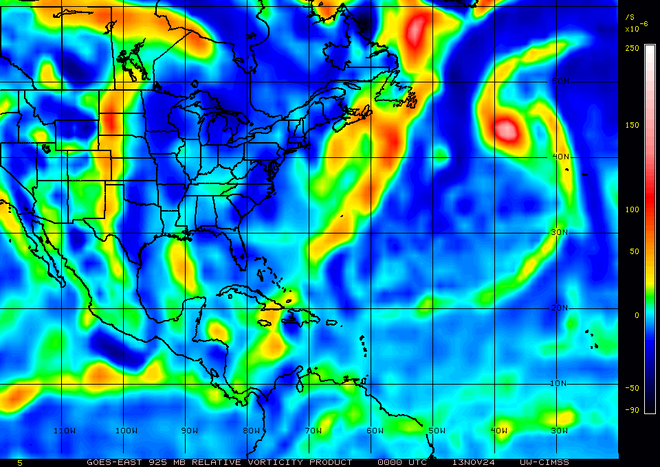
Looks like it's really ramped up the low level vorticity just in the last few hours, right as it's about to enter the warmest part of the Gulf. If this system can get 36+ hours over water like all of the models are predicting, it looks like the only things standing in the way of development into Danielle are a bit of wind shear and, most importantly, time. I'd say at this point there's a 50% chance this turns into a decent TS and a 50% chance this is a repeat of 98L, where if the system could have just stayed over the Gulf for a few more hours we'd finally have gotten another named storm. The models seem to have a good grasp on where this thing is headed, but because it's approaching land at such a sharp angle, any small deviation from its projected path could end up making all the difference here.
850mb vorticity
925mb vorticity
Looks like it's really ramped up the low level vorticity just in the last few hours, right as it's about to enter the warmest part of the Gulf. If this system can get 36+ hours over water like all of the models are predicting, it looks like the only things standing in the way of development into Danielle are a bit of wind shear and, most importantly, time. I'd say at this point there's a 50% chance this turns into a decent TS and a 50% chance this is a repeat of 98L, where if the system could have just stayed over the Gulf for a few more hours we'd finally have gotten another named storm. The models seem to have a good grasp on where this thing is headed, but because it's approaching land at such a sharp angle, any small deviation from its projected path could end up making all the difference here.
3 likes

Re: ATL: INVEST 99L - Discussion
Convection in the BOC this morning may mark the center of the lowest surface pressure.
Front already digging south of Houston into the gulf this morning apparently not forecast to linger.
Upper air flow over the TD will remain from the south or southwest until that front moves east.
Front already digging south of Houston into the gulf this morning apparently not forecast to linger.
Upper air flow over the TD will remain from the south or southwest until that front moves east.
0 likes
-
cycloneye
- Admin
- Posts: 148836
- Age: 69
- Joined: Thu Oct 10, 2002 10:54 am
- Location: San Juan, Puerto Rico
Re: ATL: INVEST 99L - Discussion
Tropical Weather Outlook
NWS National Hurricane Center Miami FL
800 AM EDT Fri Aug 19 2022
For the North Atlantic...Caribbean Sea and the Gulf of Mexico:
1. Southwestern Gulf of Mexico:
A broad area of low pressure located over the southwestern Gulf of
Mexico and the Bay of Campeche is producing poorly organized shower
activity. Environmental conditions appear favorable for slow
development, and a tropical depression could form late today or on
Saturday while the system moves northwestward across the
southwestern Gulf of Mexico. However, by Saturday night, the system
is expected to move inland over northeastern Mexico, which will end
its chances of development. An Air Force Reserve Hurricane Hunter
aircraft is scheduled to investigate the system later today, if
necessary.
* Formation chance through 48 hours...medium...40 percent.
* Formation chance through 5 days...medium...40 percent.
Forecaster Beven
0 likes
Visit the Caribbean-Central America Weather Thread where you can find at first post web cams,radars
and observations from Caribbean basin members Click Here
and observations from Caribbean basin members Click Here
-
cycloneye
- Admin
- Posts: 148836
- Age: 69
- Joined: Thu Oct 10, 2002 10:54 am
- Location: San Juan, Puerto Rico
Re: ATL: INVEST 99L - Discussion
AL, 99, 2022081912, , BEST, 0, 196N, 928W, 20, 1009, DB
0 likes
Visit the Caribbean-Central America Weather Thread where you can find at first post web cams,radars
and observations from Caribbean basin members Click Here
and observations from Caribbean basin members Click Here
-
InfernoFlameCat

- Category 5
- Posts: 2127
- Age: 22
- Joined: Mon Dec 14, 2020 10:52 am
- Location: Buford, GA
Re: ATL: INVEST 99L - Discussion
Convection still seems aligned as a wave axis. However, the system looks promising. Now is when the wave will make or break.
0 likes
I am by no means a professional. DO NOT look at my forecasts for official information or make decisions based on what I post.
Goal: to become a registered expert over tropical and subtropical cyclones.
Goal: to become a registered expert over tropical and subtropical cyclones.
-
skyline385

- Category 5
- Posts: 2728
- Age: 35
- Joined: Wed Aug 26, 2020 11:15 pm
- Location: Houston TX
Re: ATL: INVEST 99L - Discussion
Looking pretty decent right now

Sent from my iPhone using Tapatalk
Sent from my iPhone using Tapatalk
0 likes
Re: ATL: INVEST 99L - Discussion
Odds of a PTC advisory with this one, or will it depend on Recon, although if they wait for recon it could just start out as a TD? Looking at satellite, I'd venture to say the recon mission will happen.
Last edited by BobHarlem on Fri Aug 19, 2022 9:12 am, edited 1 time in total.
0 likes

Re: ATL: INVEST 99L - Discussion
When’s recon set to go out?
0 likes
Irene '11 Sandy '12 Hermine '16 5/15/2018 Derecho Fay '20 Isaias '20 Elsa '21 Henri '21 Ida '21
I am only a meteorology enthusiast who knows a decent amount about tropical cyclones. Look to the professional mets, the NHC, or your local weather office for the best information.
I am only a meteorology enthusiast who knows a decent amount about tropical cyclones. Look to the professional mets, the NHC, or your local weather office for the best information.
-
Aric Dunn
- Category 5
- Posts: 21238
- Age: 43
- Joined: Sun Sep 19, 2004 9:58 pm
- Location: Ready for the Chase.
- Contact:
Re: ATL: INVEST 99L - Discussion
Recon should find our new TD.

3 likes
Note: If I make a post that is brief. Please refer back to previous posts for the analysis or reasoning. I do not re-write/qoute what my initial post said each time.
If there is nothing before... then just ask
Space & Atmospheric Physicist, Embry-Riddle Aeronautical University,
I believe the sky is falling...
If there is nothing before... then just ask
Space & Atmospheric Physicist, Embry-Riddle Aeronautical University,
I believe the sky is falling...
-
Sciencerocks
- Category 5
- Posts: 10180
- Age: 39
- Joined: Thu Jul 06, 2017 1:51 am

-
MississippiWx

- S2K Supporter

- Posts: 1715
- Joined: Sat Aug 14, 2010 1:44 pm
- Location: Hattiesburg, Mississippi
Re: ATL: INVEST 99L - Discussion
The Bay of Campeche is doing its thing. Looks like a small tropical cyclone in the making.
0 likes
This post is not an official forecast and should not be used as such. It is just the opinion of MississippiWx and may or may not be backed by sound meteorological data. It is not endorsed by any professional institution including storm2k.org. For Official Information please refer to the NHC and NWS products.
Re: ATL: INVEST 99L - Discussion
aspen wrote:When’s recon set to go out?
Scheduled for 18z fix. So around 15:15z (11:15am edt) its scheduled to leave, and should be near the system around 2pm EDT or least in time for a potential 5pm advisory. 99l recon thread will have the details.
Last edited by BobHarlem on Fri Aug 19, 2022 9:51 am, edited 2 times in total.
0 likes
-
skyline385
- Category 5
- Posts: 2728
- Age: 35
- Joined: Wed Aug 26, 2020 11:15 pm
- Location: Houston TX
Re: ATL: INVEST 99L - Discussion
Models have been just so bad this year in the NATL, 99L going to just enforce that.
Sent from my iPhone using Tapatalk
Sent from my iPhone using Tapatalk
3 likes
-
Category5Kaiju

- Category 5
- Posts: 4317
- Joined: Thu Dec 24, 2020 12:45 pm
- Location: Seattle and Phoenix
Re: ATL: INVEST 99L - Discussion
skyline385 wrote:Models have been just so bad this year in the NATL, 99L going to just enforce that.
Sent from my iPhone using Tapatalk
Only this time, it seems to not be a ghost storm
0 likes
Unless explicitly stated, all info in my posts is based on my own opinions and observations. Tropical storms and hurricanes can be extremely dangerous. Refer to an accredited weather research agency or meteorologist if you need to make serious decisions regarding an approaching storm.
-
skyline385
- Category 5
- Posts: 2728
- Age: 35
- Joined: Wed Aug 26, 2020 11:15 pm
- Location: Houston TX
Re: ATL: INVEST 99L - Discussion
Category5Kaiju wrote:skyline385 wrote:Models have been just so bad this year in the NATL, 99L going to just enforce that.
Sent from my iPhone using Tapatalk
Only this time, it seems to not be a ghost storm
Yea the GFS in particular kept flinging majors into the Caribbean and Gulf and then completely busts on 99L. Still let’s wait for the recon to confirm.
Sent from my iPhone using Tapatalk
0 likes
Who is online
Users browsing this forum: No registered users and 25 guests