ATL: IAN - Post-Tropical - Discussion

Moderator: S2k Moderators

Message
Author
User avatar
ElectricStorm
Category 5
Category 5
Posts: 5057
Age: 24
Joined: Tue Aug 13, 2019 11:23 pm
Location: Skiatook, OK / Norman, OK

Re: ATL: IAN - Hurricane - Discussion

#4121 Postby ElectricStorm » Tue Sep 27, 2022 10:40 pm

Landy wrote:Most of my family is in the Cape Coral / Fort Myers area. Praying for a miracle right now. :(

Praying for them, hopefully they stay safe
6 likes   
B.S Meteorology, University of Oklahoma '25

Please refer to the NHC, NWS, or SPC for official information.

wx98
Category 5
Category 5
Posts: 1383
Joined: Sat Aug 25, 2018 9:24 pm

Re: ATL: IAN - Hurricane - Discussion

#4122 Postby wx98 » Tue Sep 27, 2022 10:40 pm

CronkPSU wrote:
jdjaguar wrote:
IcyTundra wrote:
Really similar to how Charley played out the only difference is that the modeling is lot better now than it was in 2004 so we were able to figure out earlier that it wouldn't be a direct hit for Tampa.

earlier as in last night at 11:00?
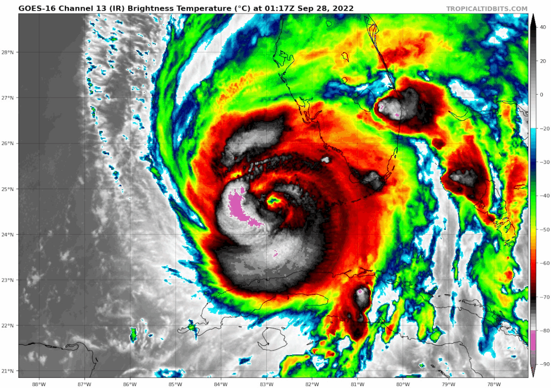
models struggled with this storm.

I find little solace


going along with this, here is the tweet I just posted talking about how the trend has not been my friend and how far off the NHC was a few days ago (yeah yeah i know, 100 miles off is well within the cone and I was ALWAYS in the cone and they were much closer than many models but let me gripe a little lol...)

https://twitter.com/richschellhase/status/1574965316115124224?s=20&t=4GsCdNrZESXQ60VWswTWiA


I went back and looked at the first forecast discussion on Friday. The 120-hour point was: 28/0600Z 26.0N 82.3W.

As we sit here right now, Ian is at 28/0300Z 24.9N 82.9W.

I know they shifted north and west and then back south and east, but you really can't get any better than that for the first advisory on a blob of thunderstorms.
8 likes   

Hurricane Mike
Category 2
Category 2
Posts: 644
Joined: Tue Apr 10, 2018 7:44 am

Re: ATL: IAN - Hurricane - Discussion

#4123 Postby Hurricane Mike » Tue Sep 27, 2022 10:41 pm

1 likes   

Fancy1001
Category 1
Category 1
Posts: 452
Joined: Thu Jul 16, 2020 10:16 pm

Re: ATL: IAN - Hurricane - Discussion

#4124 Postby Fancy1001 » Tue Sep 27, 2022 10:42 pm

Did they drop a dropsonde into the eye or not?
1 likes   

User avatar
ElectricStorm
Category 5
Category 5
Posts: 5057
Age: 24
Joined: Tue Aug 13, 2019 11:23 pm
Location: Skiatook, OK / Norman, OK

Re: ATL: IAN - Hurricane - Discussion

#4125 Postby ElectricStorm » Tue Sep 27, 2022 10:43 pm

Fancy1001 wrote:Did they drop a dropsonde into the eye or not?

Very likely yes it just takes a bit to update
1 likes   
B.S Meteorology, University of Oklahoma '25

Please refer to the NHC, NWS, or SPC for official information.

User avatar
ConvergenceZone
Category 5
Category 5
Posts: 5194
Joined: Fri Jul 29, 2005 1:40 am
Location: Northern California

Re: ATL: IAN - Hurricane - Discussion

#4126 Postby ConvergenceZone » Tue Sep 27, 2022 10:43 pm

CronkPSU wrote:
ConvergenceZone wrote:One bit of positive news is that I noticed in the forecast that Ian is already forecasted to have moved offshore and up into the east coast by Friday. That is far far faster than what was anticipated previously when it was thought that Ian would still be on the Florida coast or slightly inland dumping rain on Friday. So at least the days and days of rain doesn't seem much of a threat compared to before...Got to take any bit of good news we can get.


NHC says it is slower than their forecast earlier...from the 11PM discussion

The dynamical model consensus, TVCN, prediction has again
shifted a little to the east, and is just slightly slower on
this cycle. Therefore the official track forecast has, again, been
shifted a few degrees to the east of the previous one.


I'm surprised they would say slower, because if you look at the NHC forecast and time-line track it shows it moving inland late tomorrow afternoon where previously it didn't suppose to move inland until either late tomorrow night or Thursday Morning...
4 likes   

derpbynature
Tropical Low
Tropical Low
Posts: 18
Joined: Wed Aug 08, 2012 6:58 am
Location: Ocala, Florida

Re: ATL: IAN - Hurricane - Discussion

#4127 Postby derpbynature » Tue Sep 27, 2022 10:43 pm

Absolutely horrifying scenario for Key West and SWFL, and potentially once it gets inland, Orlando/Kissimmee.

I'm further north and west in southwest Ocala, so hopefully here it's just a rain-and-TS-strength wind event. Looking at the rain totals on the GFS, though, it's crazy how much variation there might be just within a few miles in Marion County. 20 inches in one corner, barely 4 in the other. Seems like the situation here will be VERY sensitive to any "wobbles" or movement back toward due north.

Image

Euro is a little less colorful. I thought for a second it was predicting no rain for half the county until I looked at the scale. Need a more threatening color than off-white for 12-15 inches of rain I think.
Image
6 likes   

User avatar
Texas Snowman
Storm2k Moderator
Storm2k Moderator
Posts: 6179
Joined: Fri Jan 25, 2008 11:29 am
Location: Denison, Texas

Re: ATL: IAN - Hurricane - Discussion

#4128 Postby Texas Snowman » Tue Sep 27, 2022 10:46 pm

12 likes   
The above post and any post by Texas Snowman is NOT an official forecast and should not be used as such. It is just the opinion of the poster and may or may not be backed by sound meteorological data. It is NOT endorsed by any professional institution including storm2k.org. For official information, please refer to NWS products.

User avatar
cheezyWXguy
Category 5
Category 5
Posts: 6108
Joined: Mon Feb 13, 2006 12:29 am
Location: Dallas, TX

Re: ATL: IAN - Hurricane - Discussion

#4129 Postby cheezyWXguy » Tue Sep 27, 2022 10:47 pm

Wow, that burst on the western side...I don't even know what to say
6 likes   

sikkar
Category 1
Category 1
Posts: 326
Joined: Sun Aug 26, 2012 1:44 am
Location: Florida

Re: ATL: IAN - Hurricane - Discussion

#4130 Postby sikkar » Tue Sep 27, 2022 10:48 pm

cheezyWXguy wrote:Wow, that burst on the western side...I don't even know what to say

Maxing out on all floaters.
4 likes   
Personal Forecast Disclaimer:
The posts in this forum are NOT official forecast and should not be used as such. They are just the opinion of the poster and may or may not be backed by sound meteorological data. For official information, please refer to the NHC and NWS products.

User avatar
Stormgodess
Category 1
Category 1
Posts: 301
Joined: Mon Sep 14, 2020 1:31 am

Re: ATL: IAN - Hurricane - Discussion

#4131 Postby Stormgodess » Tue Sep 27, 2022 10:49 pm

Ooooh Interesting! I hope this goes well.


 https://twitter.com/TheAstroNick/status/1574866213292875792


10 likes   

jcera
Tropical Wave
Tropical Wave
Posts: 7
Joined: Fri Jul 24, 2020 8:01 pm

Re: ATL: IAN - Hurricane - Discussion

#4132 Postby jcera » Tue Sep 27, 2022 10:50 pm

Dropsonde measured 357 kt at 850 mb lol :lol:
1 likes   

User avatar
Teban54
Category 5
Category 5
Posts: 3208
Joined: Sat May 19, 2018 1:19 pm

Re: ATL: IAN - Hurricane - Discussion

#4133 Postby Teban54 » Tue Sep 27, 2022 10:50 pm

For a system that just came out of an EWRC and is supposed to be dealing with shear and dry air, seeing this kind of convection is just surreal.
Image
7 likes   

User avatar
CronkPSU
S2K Supporter
S2K Supporter
Posts: 2014
Joined: Sun Aug 07, 2005 10:44 pm
Location: Avalon Park, FL

Re: ATL: IAN - Hurricane - Discussion

#4134 Postby CronkPSU » Tue Sep 27, 2022 10:51 pm

cheezyWXguy wrote:Wow, that burst on the western side...I don't even know what to say


 https://twitter.com/Jack_RPease/status/1574969542995890176


3 likes   
Just like Jon Snow..."I know nothing" except what I know, and most of what I know is gathered by the fine people of the NHC

User avatar
eastcoastFL
Category 5
Category 5
Posts: 3901
Age: 43
Joined: Thu Apr 12, 2007 12:29 pm
Location: Palm City, FL

Re: ATL: IAN - Hurricane - Discussion

#4135 Postby eastcoastFL » Tue Sep 27, 2022 10:51 pm

That last line of storms that came through with the tornado warning knocked out my power here in Palm city.
4 likes   
Personal Forecast Disclaimer:
The posts in this forum are NOT official forecast and should not be used as such. They are just the opinion of the poster and may or may not be backed by sound meteorological data. They are NOT endorsed by any professional institution or storm2k.org. For official information, please refer to the NHC and NWS products.

User avatar
ElectricStorm
Category 5
Category 5
Posts: 5057
Age: 24
Joined: Tue Aug 13, 2019 11:23 pm
Location: Skiatook, OK / Norman, OK

Re: ATL: IAN - Hurricane - Discussion

#4136 Postby ElectricStorm » Tue Sep 27, 2022 10:52 pm

According to the eye drop looks like the pressure actually rose a couple mb
1 likes   
B.S Meteorology, University of Oklahoma '25

Please refer to the NHC, NWS, or SPC for official information.

User avatar
cheezyWXguy
Category 5
Category 5
Posts: 6108
Joined: Mon Feb 13, 2006 12:29 am
Location: Dallas, TX

Re: ATL: IAN - Hurricane - Discussion

#4137 Postby cheezyWXguy » Tue Sep 27, 2022 10:53 pm

Outbound radar velocities are maxing out (140.9mph) in the northern part of the storm on every frame, and periodically maxing out inbound (142mph) in the southern part. Ian is ramping up
3 likes   

User avatar
Jr0d
S2K Supporter
S2K Supporter
Posts: 1409
Joined: Tue Aug 27, 2019 10:52 am
Location: Cayo Hueso

Re: ATL: IAN - Hurricane - Discussion

#4138 Postby Jr0d » Tue Sep 27, 2022 10:54 pm

gailwarning wrote:
Hope it eases up for you soon. This is what frustrates me: just because people aren't in the direct path does NOT mean they won't get significant effects. I know the mets try to convey that, but it seems to fall on deaf ears.


I was one of the few taking this seriously. Even yesterday most were convinced this would be well off to our west. Today work asked me if I was coming in at 6pm, this is when I called this morning to ask why things weren't storm ready.

I am surprised we never were issued a hurricane warning nor issued evacuation orders for non residents (tourists), hell i think it is irresponsible for the planners.

That said, looks like we will get one nore big push before it starts to ease up, that can take hours though. The current satellite shows an intense south half of Ian.
9 likes   

User avatar
jdray
Category 3
Category 3
Posts: 853
Joined: Tue Aug 31, 2004 10:07 pm
Location: NE Florida

Re: ATL: IAN - Hurricane - Discussion

#4139 Postby jdray » Tue Sep 27, 2022 10:55 pm

derpbynature wrote:Absolutely horrifying scenario for Key West and SWFL, and potentially once it gets inland, Orlando/Kissimmee.

I'm further north and west in southwest Ocala, so hopefully here it's just a rain-and-TS-strength wind event. Looking at the rain totals on the GFS, though, it's crazy how much variation there might be just within a few miles in Marion County. 20 inches in one corner, barely 4 in the other. Seems like the situation here will be VERY sensitive to any "wobbles" or movement back toward due north.

https://i.imgur.com/h5oQdmw.png

Euro is a little less colorful. I thought for a second it was predicting no rain for half the county until I looked at the scale. Need a more threatening color than off-white for 12-15 inches of rain I think.
https://i.imgur.com/3cIxWeT.png


The majority of the rainfall will be from the bands that roll through pre and post. Its always a challenge to predict which areas get the heaviest rain. Florida is bad enough with pop up showers, I truly feel for the Mets trying to forecast what the rainfall will be.
1 likes   

User avatar
eastcoastFL
Category 5
Category 5
Posts: 3901
Age: 43
Joined: Thu Apr 12, 2007 12:29 pm
Location: Palm City, FL

Re: ATL: IAN - Hurricane - Discussion

#4140 Postby eastcoastFL » Tue Sep 27, 2022 10:55 pm

ConvergenceZone wrote:
CronkPSU wrote:
ConvergenceZone wrote:One bit of positive news is that I noticed in the forecast that Ian is already forecasted to have moved offshore and up into the east coast by Friday. That is far far faster than what was anticipated previously when it was thought that Ian would still be on the Florida coast or slightly inland dumping rain on Friday. So at least the days and days of rain doesn't seem much of a threat compared to before...Got to take any bit of good news we can get.


NHC says it is slower than their forecast earlier...from the 11PM discussion

The dynamical model consensus, TVCN, prediction has again
shifted a little to the east, and is just slightly slower on
this cycle. Therefore the official track forecast has, again, been
shifted a few degrees to the east of the previous one.


I'm surprised they would say slower, because if you look at the NHC forecast and time-line track it shows it moving inland late tomorrow afternoon where previously it didn't suppose to move inland until either late tomorrow night or Thursday Morning...


I think you're comparing it to when it was supposed to landfall further north.
4 likes   
Personal Forecast Disclaimer:
The posts in this forum are NOT official forecast and should not be used as such. They are just the opinion of the poster and may or may not be backed by sound meteorological data. They are NOT endorsed by any professional institution or storm2k.org. For official information, please refer to the NHC and NWS products.


Return to “2022”

Who is online

Users browsing this forum: No registered users and 123 guests