ATL: IAN - Post-Tropical - Discussion

Moderator: S2k Moderators

Message
Author
Chemmers
Tropical Storm
Tropical Storm
Posts: 220
Joined: Wed Jul 22, 2020 6:16 am

Re: ATL: IAN - Hurricane - Discussion

#4241 Postby Chemmers » Wed Sep 28, 2022 3:32 am

AxaltaRacing24 wrote:
Chemmers wrote:it is now 942mb that is a 12mb drop since last recon :double:

Figured. It has looked really good after the ERC was completed.


definitely, i am hoping it doesn't keep intensifying all the way to land fall, but after the ERC dont know much in it way to stop it now
3 likes   

User avatar
AubreyStorm
Category 1
Category 1
Posts: 337
Age: 44
Joined: Fri Jun 16, 2017 6:21 pm
Location: Texas, USA

Re: ATL: IAN - Hurricane - Discussion

#4242 Postby AubreyStorm » Wed Sep 28, 2022 3:35 am

3 likes   
The posts are NOT an official forecast. Please REFER to the NHC and NWS for official forecasts and products.

User avatar
Iceresistance
Category 5
Category 5
Posts: 9290
Age: 21
Joined: Sat Oct 10, 2020 9:45 am
Location: Tecumseh, OK/Norman, OK

Re: ATL: IAN - Hurricane - Discussion

#4243 Postby Iceresistance » Wed Sep 28, 2022 3:36 am


The NW Quad only supports 105-108 knots, the southern half appears to be the strongest half and they've yet to make the first complete pass through there.
2 likes   
Bill 2015 & Beta 2020

Winter 2020-2021 :cold:

All observations are in Tecumseh, OK unless otherwise noted.

Winter posts are focused mainly for Oklahoma & Texas.

Take any of my forecasts with a grain of salt, refer to the NWS, SPC, and NHC for official information

Never say Never with weather! Because ANYTHING is possible!

User avatar
Owasso
Category 1
Category 1
Posts: 309
Joined: Sat Aug 22, 2020 11:14 pm
Location: Chicago, Illinois

Re: ATL: IAN - Hurricane - Discussion

#4244 Postby Owasso » Wed Sep 28, 2022 3:37 am

141kt FL :double:
9 likes   

User avatar
Iceresistance
Category 5
Category 5
Posts: 9290
Age: 21
Joined: Sat Oct 10, 2020 9:45 am
Location: Tecumseh, OK/Norman, OK

Re: ATL: IAN - Hurricane - Discussion

#4245 Postby Iceresistance » Wed Sep 28, 2022 3:40 am

Owasso wrote:141kt FL :double:


Jeez, that is in the eastern quad of the eyewall, I'm wondering on what the intensity would be on the southern eyewall.
1 likes   
Bill 2015 & Beta 2020

Winter 2020-2021 :cold:

All observations are in Tecumseh, OK unless otherwise noted.

Winter posts are focused mainly for Oklahoma & Texas.

Take any of my forecasts with a grain of salt, refer to the NWS, SPC, and NHC for official information

Never say Never with weather! Because ANYTHING is possible!

User avatar
Extratropical94
Professional-Met
Professional-Met
Posts: 3538
Age: 30
Joined: Wed Oct 20, 2010 6:36 am
Location: Hamburg, Germany
Contact:

Re: ATL: IAN - Hurricane - Discussion

#4246 Postby Extratropical94 » Wed Sep 28, 2022 3:41 am

Iceresistance wrote:
Owasso wrote:141kt FL :double:


Jeez, that is in the eastern quad of the eyewall, I'm wondering on what the intensity would be on the southern eyewall.


I'd guess around 120-130 kt at flight level. Right front quadrant should be the strongest
1 likes   
54° 11' 59'' N, 9° 9' 20'' E
Boomer Sooner!
Go Broncos! Go Cards! Go Niners!
- Daniel

caneman
Category 5
Category 5
Posts: 1447
Joined: Fri Sep 05, 2014 5:44 am
Location: Clearwater Beach, Fl

Re: ATL: IAN - Hurricane - Discussion

#4247 Postby caneman » Wed Sep 28, 2022 3:42 am

Bocadude85 wrote:Ian has been wobbling to the N the last few hours, however that last few radar frames look to be wobbling back to the NNE


Those weren't wobbles, that went on for 4 or 5 hours. Looking more like Sarasota to me
Last edited by caneman on Wed Sep 28, 2022 3:46 am, edited 1 time in total.
1 likes   

caneman
Category 5
Category 5
Posts: 1447
Joined: Fri Sep 05, 2014 5:44 am
Location: Clearwater Beach, Fl

Re: ATL: IAN - Hurricane - Discussion

#4248 Postby caneman » Wed Sep 28, 2022 3:45 am

AxaltaRacing24 wrote:
REDHurricane wrote:Still nearly no discernible right turn in the past few hours...

https://media.giphy.com/media/DfGquH4AURP8QaTB4P/giphy.gif

It’s forecasted to wobble north, even NNW for a short bit before eventually making the turn to the right later this morning.

So what we are seeing currently are the final wobbles before the “final approach.”


Once again those weren't just wobbles, it pretty much went North for 5 hours. The Euro also now has it cutting in much closer to Tampa After landfall.
1 likes   

User avatar
Extratropical94
Professional-Met
Professional-Met
Posts: 3538
Age: 30
Joined: Wed Oct 20, 2010 6:36 am
Location: Hamburg, Germany
Contact:

Re: ATL: IAN - Hurricane - Discussion

#4249 Postby Extratropical94 » Wed Sep 28, 2022 3:45 am

943/15 on the center drop. Supports 941-42
5 likes   
54° 11' 59'' N, 9° 9' 20'' E
Boomer Sooner!
Go Broncos! Go Cards! Go Niners!
- Daniel

User avatar
Iceresistance
Category 5
Category 5
Posts: 9290
Age: 21
Joined: Sat Oct 10, 2020 9:45 am
Location: Tecumseh, OK/Norman, OK

Re: ATL: IAN - Hurricane - Discussion

#4250 Postby Iceresistance » Wed Sep 28, 2022 3:48 am

There is still an insane amount of lightning in the northern eyewall
2 likes   
Bill 2015 & Beta 2020

Winter 2020-2021 :cold:

All observations are in Tecumseh, OK unless otherwise noted.

Winter posts are focused mainly for Oklahoma & Texas.

Take any of my forecasts with a grain of salt, refer to the NWS, SPC, and NHC for official information

Never say Never with weather! Because ANYTHING is possible!

AxaltaRacing24
Category 5
Category 5
Posts: 1753
Age: 25
Joined: Wed Jul 27, 2016 11:14 am
Location: Jupiter, FL

Re: ATL: IAN - Hurricane - Discussion

#4251 Postby AxaltaRacing24 » Wed Sep 28, 2022 3:48 am

caneman wrote:
AxaltaRacing24 wrote:
REDHurricane wrote:Still nearly no discernible right turn in the past few hours...

https://media.giphy.com/media/DfGquH4AURP8QaTB4P/giphy.gif

It’s forecasted to wobble north, even NNW for a short bit before eventually making the turn to the right later this morning.

So what we are seeing currently are the final wobbles before the “final approach.”


Once again those weren't just wobbles, it pretty much went North for 5 hours. The Euro also now has it cutting in much closer to Tampa After landfall.

It went that way for a few hours, but the 00z model suite forecasted that motion tonight, so it was expected. Now we wait for the upcoming turn.
2 likes   

caneman
Category 5
Category 5
Posts: 1447
Joined: Fri Sep 05, 2014 5:44 am
Location: Clearwater Beach, Fl

Re: ATL: IAN - Hurricane - Discussion

#4252 Postby caneman » Wed Sep 28, 2022 3:53 am

AxaltaRacing24 wrote:
caneman wrote:
AxaltaRacing24 wrote:It’s forecasted to wobble north, even NNW for a short bit before eventually making the turn to the right later this morning.

So what we are seeing currently are the final wobbles before the “final approach.”


Once again those weren't just wobbles, it pretty much went North for 5 hours. The Euro also now has it cutting in much closer to Tampa After landfall.

It went that way for a few hours, but the 00z model suite forecasted that motion tonight, so it was expected. Now we wait for the upcoming turn.


Once again, it wasn't expected. It was forecast to move at .15 degrees and it moved at nearly .00. Further, the Euro now has it moving in at a. NNW angle and not NW. I've been watching since midnight and this will likely affect my area even more. BELIEVE what you will , I'm not getting into a wobble watching war.
1 likes   

User avatar
Extratropical94
Professional-Met
Professional-Met
Posts: 3538
Age: 30
Joined: Wed Oct 20, 2010 6:36 am
Location: Hamburg, Germany
Contact:

Re: ATL: IAN - Hurricane - Discussion

#4253 Postby Extratropical94 » Wed Sep 28, 2022 3:56 am

Cat 4 officially.
942/120

...AIR FORCE HURRICANE HUNTERS FIND IAN HAS STRENGTHENED INTO AN
EXTREMELY DANGEROUS CATEGORY 4 HURRICANE...
...EXPECTED TO CAUSE LIFE-THREATENING STORM SURGE, CATASTROPHIC
WINDS AND FLOODING IN THE FLORIDA PENINSULA...


SUMMARY OF 500 AM EDT...0900 UTC...INFORMATION
----------------------------------------------
LOCATION...25.6N 82.9W
ABOUT 75 MI...125 KM WSW OF NAPLES FLORIDA
ABOUT 105 MI...165 KM SSW OF PUNTA GORDA FLORIDA
MAXIMUM SUSTAINED WINDS...140 MPH...220 KM/H
PRESENT MOVEMENT...NNE OR 15 DEGREES AT 10 MPH...17 KM/H
MINIMUM CENTRAL PRESSURE...942 MB...27.82 INCHES
8 likes   
54° 11' 59'' N, 9° 9' 20'' E
Boomer Sooner!
Go Broncos! Go Cards! Go Niners!
- Daniel

User avatar
Iceresistance
Category 5
Category 5
Posts: 9290
Age: 21
Joined: Sat Oct 10, 2020 9:45 am
Location: Tecumseh, OK/Norman, OK

Re: ATL: IAN - Hurricane - Discussion

#4254 Postby Iceresistance » Wed Sep 28, 2022 4:03 am

Extratropical94 wrote:Cat 4 officially.
942/120

...AIR FORCE HURRICANE HUNTERS FIND IAN HAS STRENGTHENED INTO AN
EXTREMELY DANGEROUS CATEGORY 4 HURRICANE...
...EXPECTED TO CAUSE LIFE-THREATENING STORM SURGE, CATASTROPHIC
WINDS AND FLOODING IN THE FLORIDA PENINSULA...


SUMMARY OF 500 AM EDT...0900 UTC...INFORMATION
----------------------------------------------
LOCATION...25.6N 82.9W
ABOUT 75 MI...125 KM WSW OF NAPLES FLORIDA
ABOUT 105 MI...165 KM SSW OF PUNTA GORDA FLORIDA
MAXIMUM SUSTAINED WINDS...140 MPH...220 KM/H
PRESENT MOVEMENT...NNE OR 15 DEGREES AT 10 MPH...17 KM/H
MINIMUM CENTRAL PRESSURE...942 MB...27.82 INCHES


My goodness, Ian has never been this close to becoming Category 5.
2 likes   
Bill 2015 & Beta 2020

Winter 2020-2021 :cold:

All observations are in Tecumseh, OK unless otherwise noted.

Winter posts are focused mainly for Oklahoma & Texas.

Take any of my forecasts with a grain of salt, refer to the NWS, SPC, and NHC for official information

Never say Never with weather! Because ANYTHING is possible!

User avatar
StormingB81
S2K Supporter
S2K Supporter
Posts: 5676
Age: 43
Joined: Thu Aug 27, 2009 1:45 am
Location: Rockledge, Florida

Re: ATL: IAN - Hurricane - Discussion

#4255 Postby StormingB81 » Wed Sep 28, 2022 4:04 am

Seeing what Ian did overnight and the GFS model run for instance, I wonder if they wish they gave the east coast of Florida a Hurricane Watch, which yes I know would be a warning now
1 likes   

User avatar
weeniepatrol
Category 5
Category 5
Posts: 1276
Joined: Sat Aug 22, 2020 5:30 pm
Location: WA State

Re: ATL: IAN - Hurricane - Discussion

#4256 Postby weeniepatrol » Wed Sep 28, 2022 4:05 am

EVERY YEAR. Wave breaking, 2013, cold canary current. I want a refund
8 likes   

User avatar
AubreyStorm
Category 1
Category 1
Posts: 337
Age: 44
Joined: Fri Jun 16, 2017 6:21 pm
Location: Texas, USA

Re: ATL: IAN - Hurricane - Discussion

#4257 Postby AubreyStorm » Wed Sep 28, 2022 4:07 am

Iceresistance wrote:
Extratropical94 wrote:Cat 4 officially.
942/120

...AIR FORCE HURRICANE HUNTERS FIND IAN HAS STRENGTHENED INTO AN
EXTREMELY DANGEROUS CATEGORY 4 HURRICANE...
...EXPECTED TO CAUSE LIFE-THREATENING STORM SURGE, CATASTROPHIC
WINDS AND FLOODING IN THE FLORIDA PENINSULA...


SUMMARY OF 500 AM EDT...0900 UTC...INFORMATION
----------------------------------------------
LOCATION...25.6N 82.9W
ABOUT 75 MI...125 KM WSW OF NAPLES FLORIDA
ABOUT 105 MI...165 KM SSW OF PUNTA GORDA FLORIDA
MAXIMUM SUSTAINED WINDS...140 MPH...220 KM/H
PRESENT MOVEMENT...NNE OR 15 DEGREES AT 10 MPH...17 KM/H
MINIMUM CENTRAL PRESSURE...942 MB...27.82 INCHES


My goodness, Ian has never been this close to becoming Category 5.


An extremely dangerous situation for Florida.
1 likes   
The posts are NOT an official forecast. Please REFER to the NHC and NWS for official forecasts and products.

User avatar
HDGator
S2K Supporter
S2K Supporter
Posts: 242
Joined: Fri Sep 17, 2004 3:03 pm
Location: Lewisville, NC

Re: ATL: IAN - Hurricane - Discussion

#4258 Postby HDGator » Wed Sep 28, 2022 4:07 am

StormingB81 wrote:Seeing what Ian did overnight and the GFS model run for instance, I wonder if they wish they gave the east coast of Florida a Hurricane Watch, which yes I know would be a warning now

Well, they gave Key West a surge warning after they were standing in water.
7 likes   
Personal Forecast Disclaimer:
The posts in this forum are NOT official forecast and should not be used as such. They are just the opinion of the poster and may or may not be backed by sound meteorological data. They are NOT endorsed by any professional institution or storm2k.org. For official information, please refer to the NHC and NWS products.

User avatar
Hammy
Category 5
Category 5
Posts: 5849
Age: 42
Joined: Fri May 25, 2012 5:25 pm
Contact:

Re: ATL: IAN - Hurricane - Discussion

#4259 Postby Hammy » Wed Sep 28, 2022 4:08 am

weeniepatrol wrote:EVERY YEAR. Wave breaking, 2013, cold canary current. I want a refund


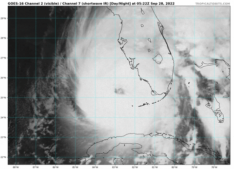
This season almost seems like it's taking vengeance for all the early downplaying--we have the strongest storm of the season, in the Gulf, about to slam into the west coast of Florida, after most people wrote off the Gulf as too hostile/too late in the season just a week or two ago

Good lesson in always being prepared no matter how quiet it looks or how late it is
5 likes   
The above post is not official and should not be used as such. It is the opinion of the poster and may or may not be backed by sound meteorological data. It is not endorsed by any professional institution or storm2k.org. For official information, please refer to the NHC and NWS products.

User avatar
Iceresistance
Category 5
Category 5
Posts: 9290
Age: 21
Joined: Sat Oct 10, 2020 9:45 am
Location: Tecumseh, OK/Norman, OK

Re: ATL: IAN - Hurricane - Discussion

#4260 Postby Iceresistance » Wed Sep 28, 2022 4:08 am

AubreyStorm wrote:
Iceresistance wrote:
Extratropical94 wrote:Cat 4 officially.
942/120

...AIR FORCE HURRICANE HUNTERS FIND IAN HAS STRENGTHENED INTO AN
EXTREMELY DANGEROUS CATEGORY 4 HURRICANE...
...EXPECTED TO CAUSE LIFE-THREATENING STORM SURGE, CATASTROPHIC
WINDS AND FLOODING IN THE FLORIDA PENINSULA...


SUMMARY OF 500 AM EDT...0900 UTC...INFORMATION
----------------------------------------------
LOCATION...25.6N 82.9W
ABOUT 75 MI...125 KM WSW OF NAPLES FLORIDA
ABOUT 105 MI...165 KM SSW OF PUNTA GORDA FLORIDA
MAXIMUM SUSTAINED WINDS...140 MPH...220 KM/H
PRESENT MOVEMENT...NNE OR 15 DEGREES AT 10 MPH...17 KM/H
MINIMUM CENTRAL PRESSURE...942 MB...27.82 INCHES


My goodness, Ian has never been this close to becoming Category 5.


An extremely dangerous situation for Florida.


I know someone that lives in Orlando, I may have stronger justification to get them to evacuate. You don't want to mess around with a Category 4 monster.
4 likes   
Bill 2015 & Beta 2020

Winter 2020-2021 :cold:

All observations are in Tecumseh, OK unless otherwise noted.

Winter posts are focused mainly for Oklahoma & Texas.

Take any of my forecasts with a grain of salt, refer to the NWS, SPC, and NHC for official information

Never say Never with weather! Because ANYTHING is possible!


Return to “2022”

Who is online

Users browsing this forum: No registered users and 5 guests