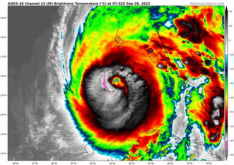
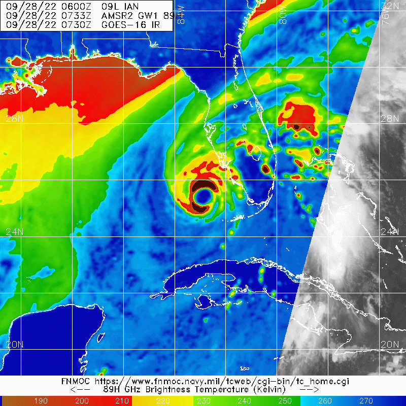
ATL: IAN - Post-Tropical - Discussion

Moderator: S2k Moderators

Message
Author
User avatar
weeniepatrol
Category 5
Category 5
Posts: 1276
Joined: Sat Aug 22, 2020 5:30 pm
Location: WA State

Re: ATL: IAN - Hurricane - Discussion

#4281 Postby weeniepatrol » Wed Sep 28, 2022 4:40 am


If Ian continues to deepen unfortunately could see some of those mixing down to the surface.
1 likes   

User avatar
Iceresistance
Category 5
Category 5
Posts: 9289
Age: 21
Joined: Sat Oct 10, 2020 9:45 am
Location: Tecumseh, OK/Norman, OK

Re: ATL: IAN - Hurricane - Discussion

#4282 Postby Iceresistance » Wed Sep 28, 2022 4:43 am

weeniepatrol wrote:


If Ian continues to deepen unfortunately could see some of those mixing down to the surface.

Yeah, the data on the Northern Eyewall Dropsonde just came in and it's even more terrifying! :eek: :eek:

Image
https://s5.gifyu.com/images/Northern-Eyewall-Dropsonde-on-Ian.png
2 likes   
Bill 2015 & Beta 2020

Winter 2020-2021 :cold:

All observations are in Tecumseh, OK unless otherwise noted.

Winter posts are focused mainly for Oklahoma & Texas.

Take any of my forecasts with a grain of salt, refer to the NWS, SPC, and NHC for official information

Never say Never with weather! Because ANYTHING is possible!

User avatar
HDGator
S2K Supporter
S2K Supporter
Posts: 242
Joined: Fri Sep 17, 2004 3:03 pm
Location: Lewisville, NC

Re: ATL: IAN - Hurricane - Discussion

#4283 Postby HDGator » Wed Sep 28, 2022 4:45 am

Iceresistance wrote:
weeniepatrol wrote:


If Ian continues to deepen unfortunately could see some of those mixing down to the surface.

Yeah, the data on the Northern Eyewall Dropsonde just came in and it's even more terrifying! :eek: :eek:

https://s5.gifyu.com/images/Northern-Eyewall-Dropsonde-on-Ian.png

131 kt at the surface!!!
:double:
0 likes   
Personal Forecast Disclaimer:
The posts in this forum are NOT official forecast and should not be used as such. They are just the opinion of the poster and may or may not be backed by sound meteorological data. They are NOT endorsed by any professional institution or storm2k.org. For official information, please refer to the NHC and NWS products.

User avatar
Extratropical94
Professional-Met
Professional-Met
Posts: 3538
Age: 30
Joined: Wed Oct 20, 2010 6:36 am
Location: Hamburg, Germany
Contact:

Re: ATL: IAN - Hurricane - Discussion

#4284 Postby Extratropical94 » Wed Sep 28, 2022 4:52 am

Iceresistance wrote:
weeniepatrol wrote:


If Ian continues to deepen unfortunately could see some of those mixing down to the surface.

Yeah, the data on the Northern Eyewall Dropsonde just came in and it's even more terrifying! :eek: :eek:

https://s5.gifyu.com/images/Northern-Eyewall-Dropsonde-on-Ian.png


That wind profile is vile. Especially considering that these measurements weren't even recorded in the strongest quadrant.
1 likes   
54° 11' 59'' N, 9° 9' 20'' E
Boomer Sooner!
Go Broncos! Go Cards! Go Niners!
- Daniel

User avatar
Iceresistance
Category 5
Category 5
Posts: 9289
Age: 21
Joined: Sat Oct 10, 2020 9:45 am
Location: Tecumseh, OK/Norman, OK

Re: ATL: IAN - Hurricane - Discussion

#4285 Postby Iceresistance » Wed Sep 28, 2022 4:53 am

Extratropical94 wrote:
Iceresistance wrote:
weeniepatrol wrote:

If Ian continues to deepen unfortunately could see some of those mixing down to the surface.

Yeah, the data on the Northern Eyewall Dropsonde just came in and it's even more terrifying! :eek: :eek:

https://s5.gifyu.com/images/Northern-Eyewall-Dropsonde-on-Ian.png


That wind profile is vile. Especially considering that these measurements weren't even recorded in the strongest quadrant.


Could see an upgrade to 150 mph if we have another dropsonde showing the same thing and/or stronger winds at the surface. Ian should not be taken lightly
2 likes   
Bill 2015 & Beta 2020

Winter 2020-2021 :cold:

All observations are in Tecumseh, OK unless otherwise noted.

Winter posts are focused mainly for Oklahoma & Texas.

Take any of my forecasts with a grain of salt, refer to the NWS, SPC, and NHC for official information

Never say Never with weather! Because ANYTHING is possible!

caneman
Category 5
Category 5
Posts: 1447
Joined: Fri Sep 05, 2014 5:44 am
Location: Clearwater Beach, Fl

Re: ATL: IAN - Hurricane - Discussion

#4286 Postby caneman » Wed Sep 28, 2022 4:56 am

Unless there is a turn now, looks like it's heading for Englewood or Venice possibly Sarasota
0 likes   

User avatar
Hurricane2022
Category 5
Category 5
Posts: 1571
Joined: Tue Aug 23, 2022 11:38 pm
Location: Araçatuba, Brazil

Re: ATL: IAN - Hurricane - Discussion

#4287 Postby Hurricane2022 » Wed Sep 28, 2022 4:56 am

1 likes   
Sorry for the bad English sometimes...!
For reliable and detailed information for any meteorological phenomenon, please consult the National Hurricane Center, Joint Typhoon Warning Center , or your local Meteo Center.

--------

Una cvm Christo, pro Christo, et in Christo. Sit nomen Domini benedictvm.

hurricaneCW
Category 5
Category 5
Posts: 1794
Joined: Wed Mar 03, 2010 6:20 am
Location: Toms River, NJ

Re: ATL: IAN - Hurricane - Discussion

#4288 Postby hurricaneCW » Wed Sep 28, 2022 4:57 am

It seems like we have another case of a strengthening cane til landfall. Landfall just north of Ft. Myers will deliver a catastrophic surge into the region.

Flooding/surge will be 90% of the story.
2 likes   

User avatar
cjrciadt
S2K Supporter
S2K Supporter
Posts: 1616
Joined: Mon Aug 22, 2005 1:11 pm
Location: Kissimmee, FL

Re: ATL: IAN - Hurricane - Discussion

#4289 Postby cjrciadt » Wed Sep 28, 2022 5:01 am

Sail Drone being used as well?
0 likes   

Ken711
Category 5
Category 5
Posts: 1074
Joined: Tue Aug 28, 2012 12:48 pm

Re: ATL: IAN - Hurricane - Discussion

#4290 Postby Ken711 » Wed Sep 28, 2022 5:01 am


From the NHC 5 AM discussion:

Ian has jogged a little to the left this morning, but the longer-term motion remains north-northeastward or 015 degrees at 9 kt. The hurricane should continue moving north-northeastward through Thursday between the western side of a subtropical ridge and a broad trough over the eastern United States.
1 likes   

User avatar
Bocadude85
Category 5
Category 5
Posts: 2991
Age: 38
Joined: Mon Apr 18, 2005 2:20 pm
Location: Honolulu,Hi

Re: ATL: IAN - Hurricane - Discussion

#4291 Postby Bocadude85 » Wed Sep 28, 2022 5:02 am

The surge that is going to funnel into Charlotte Harbor is going to be much worse then what they had during Charley
1 likes   

jconsor
Professional-Met
Professional-Met
Posts: 552
Joined: Mon Jun 30, 2008 9:31 pm
Location: Jerusalem, Israel
Contact:

Re: ATL: IAN - Hurricane - Discussion

#4292 Postby jconsor » Wed Sep 28, 2022 5:02 am

Great point here by Brian. Though Ian's intensity and track leading up to landfall is very similar to Charley, Ian is much larger than Charley! This will lead to a higher storm surge and much larger area impacted by destructive storm surge and winds.

 https://twitter.com/BMcNoldy/status/1575061321837445120


Last edited by jconsor on Wed Sep 28, 2022 5:04 am, edited 1 time in total.
1 likes   

wx98
Category 5
Category 5
Posts: 1383
Joined: Sat Aug 25, 2018 9:24 pm

Re: ATL: IAN - Hurricane - Discussion

#4293 Postby wx98 » Wed Sep 28, 2022 5:04 am

West to east pass coming from the NOAA plane.
0 likes   

User avatar
johngaltfla
Category 5
Category 5
Posts: 2069
Joined: Sun Jul 10, 2005 9:17 pm
Location: Sarasota County, FL
Contact:

Re: ATL: IAN - Hurricane - Discussion

#4294 Postby johngaltfla » Wed Sep 28, 2022 5:04 am

caneman wrote:
johngaltfla wrote:
caneman wrote:
Yep it went due North for 5 hours. Curious to see if hits Englewood. As this point it doesn't matter I suppose, they're about 10 or 15 miles west of Port Charlotte so affects will likely be same other than that route may take it much closer to Tampa once inland.


Since this is my backyard, Boca Grande is what the locals are saying and for all practical purposes is that's Englewood. If it shifts by an few miles north it's Venice, south it's Punta Gorda. Regardless Florida Bros, standby for a week without power. Good luck to my fellow S2Kers.


Let's hope it's just a week. Frances, Jeanne, Irma was 5 or 6 days each. This one may be weeks. Stay safe my Florida peeps.


Irma was 10 days for me. But I've moved since then so easily a week.
1 likes   

User avatar
REDHurricane
Category 1
Category 1
Posts: 398
Age: 27
Joined: Sun Jul 03, 2022 2:36 pm
Location: Northeast Pacific Ocean

Re: ATL: IAN - Hurricane - Discussion

#4295 Postby REDHurricane » Wed Sep 28, 2022 5:05 am

Image

Looks like it's trying to wrap that ridiculous convection all the way around the eye right as it makes landfall :(
3 likes   

St0rmTh0r
Category 1
Category 1
Posts: 369
Joined: Tue Jul 14, 2020 8:04 pm

Re: ATL: IAN - Hurricane - Discussion

#4296 Postby St0rmTh0r » Wed Sep 28, 2022 5:07 am

REDHurricane wrote:https://media.giphy.com/media/2p5KStGYTpBUs7Hm6g/giphy.gif

Looks like it's trying to wrap that ridiculous convection all the way around the eye right as it makes landfall :(

cant believe this is making a run for cat 5
0 likes   

wx98
Category 5
Category 5
Posts: 1383
Joined: Sat Aug 25, 2018 9:24 pm

Re: ATL: IAN - Hurricane - Discussion

#4297 Postby wx98 » Wed Sep 28, 2022 5:08 am

UW - CIMSS
ADVANCED DVORAK TECHNIQUE
ADT-Version 9.0
Tropical Cyclone Intensity Algorithm

----- Current Analysis -----
Date : 28 SEP 2022 Time : 092020 UTC
Lat : 25:38:59 N Lon : 82:53:23 W


CI# /Pressure/ Vmax
6.8 / 925mb / 135kts


Final T# Adj T# Raw T#
6.8 6.9 6.9

Estimated radius of max. wind based on IR : 20 km

Center Temp : -5.9C Cloud Region Temp : -73.3C

Scene Type : EYE

Subtropical Adjustment : OFF

Extratropical Adjustment : OFF

Positioning Method : ARCHER POSITIONING
0 likes   

User avatar
Owasso
Category 1
Category 1
Posts: 309
Joined: Sat Aug 22, 2020 11:14 pm
Location: Chicago, Illinois

Re: ATL: IAN - Hurricane - Discussion

#4298 Postby Owasso » Wed Sep 28, 2022 5:08 am

Image
8 likes   

User avatar
skyline385
Category 5
Category 5
Posts: 2728
Age: 35
Joined: Wed Aug 26, 2020 11:15 pm
Location: Houston TX

Re: ATL: IAN - Hurricane - Discussion

#4299 Postby skyline385 » Wed Sep 28, 2022 5:11 am

Iceresistance wrote:
weeniepatrol wrote:


If Ian continues to deepen unfortunately could see some of those mixing down to the surface.

Yeah, the data on the Northern Eyewall Dropsonde just came in and it's even more terrifying! :eek: :eek:

Image
https://s5.gifyu.com/images/Northern-Eyewall-Dropsonde-on-Ian.png

Just woke up and wow, am now curious why did NHC only use 140 mph for the advisory?


Sent from my iPhone using Tapatalk
0 likes   

User avatar
Iceresistance
Category 5
Category 5
Posts: 9289
Age: 21
Joined: Sat Oct 10, 2020 9:45 am
Location: Tecumseh, OK/Norman, OK

Re: ATL: IAN - Hurricane - Discussion

#4300 Postby Iceresistance » Wed Sep 28, 2022 5:12 am

skyline385 wrote:
Iceresistance wrote:
weeniepatrol wrote:

If Ian continues to deepen unfortunately could see some of those mixing down to the surface.

Yeah, the data on the Northern Eyewall Dropsonde just came in and it's even more terrifying! :eek: :eek:

https://s5.gifyu.com/images/Northern-Eyewall-Dropsonde-on-Ian.png

Just woke up and wow, am now curious why did NHC only use 140 mph for the advisory?


Sent from my iPhone using Tapatalk


Dropsonde data came in after the advisory came out.
4 likes   
Bill 2015 & Beta 2020

Winter 2020-2021 :cold:

All observations are in Tecumseh, OK unless otherwise noted.

Winter posts are focused mainly for Oklahoma & Texas.

Take any of my forecasts with a grain of salt, refer to the NWS, SPC, and NHC for official information

Never say Never with weather! Because ANYTHING is possible!


Return to “2022”

Who is online

Users browsing this forum: No registered users and 4 guests