ATL: IAN - Post-Tropical - Discussion

Moderator: S2k Moderators

Message
Author
Rail Dawg
S2K Supporter
S2K Supporter
Posts: 326
Joined: Mon Aug 27, 2012 5:02 pm
Location: Where the eye makes landfall.

Re: ATL: IAN - Hurricane - Discussion

#4901 Postby Rail Dawg » Wed Sep 28, 2022 11:10 am

gailwarning wrote:
Rail Dawg wrote:Right now I would be in a parking lot garage in Ft Meyers. My truck was my survival. In it was everything I needed to survive two weeks if I couldn’t get out after a storm.

I would be one of those dummies walking around as the eyewall approaches. However I also know there is a very safe place for the truck so there are no worries. You know when it’s time to hightail it to the garage.

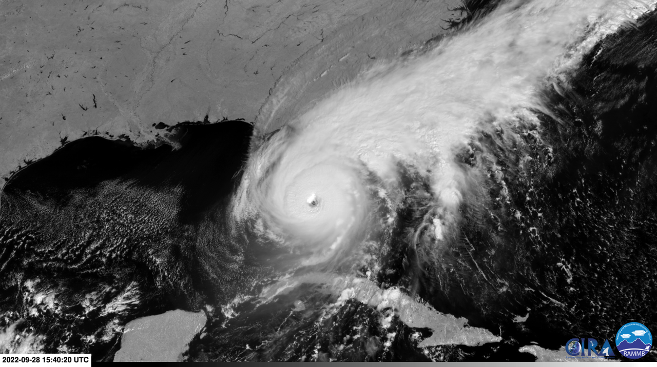
You know there is a monster just 10 hours away. Every moment you feel and see the changes. You still can drive away and not endure the misery of the aftermath but you are committed to a Cat 5 hurricane.

There are going to be many people who think that watching a video of a Cat 5 gives them understanding of the power. It absolutely does not. There is going to be a moment as the water rises and the Fists of God come raining down when they will realize they made a critical error.

I loved going into these. I don’t take pictures or video because of what I said… you have to be there to feel it. I wasn’t there for the clicks. We may lose some hurricane chasers in Ian because it’s downright foolish to chase a Cat 5 without several smaller storms under your belt.

This is a major disaster unfolding. Please keep the info rolling in.

Chuck


Please contact the Mike's Weather Page guy. He thinks he's a storm chaser now and I'm thinking he's gonna get himself in a world of hurt.


It depends on his prior experience of course but you may be right. I don’t know Mike.

It takes years to learn not only the weather element but the human element. The sheer panic ahead of the storm then dealing with the looting and other issues when people have lost everything.

Chasing means being a part of the aftermath. Getting out is incredibly difficult but if you do it right you will meet the first responders coming in. They will be very appreciative of the road-clearing you and the locals have done.

Again it takes years of practice to smartly chase a Cat 5. Most chasers I have seen are woefully unprepared.

Chuck
9 likes   
Although I have been a hurricane forecaster since 1980 that only means I've been wrong lots of times.

User avatar
Hurrilurker
Category 2
Category 2
Posts: 719
Joined: Mon Jun 09, 2003 3:32 pm
Location: San Francisco, CA

Re: ATL: IAN - Hurricane - Discussion

#4902 Postby Hurrilurker » Wed Sep 28, 2022 11:10 am

I definitely didn't expect borderline Cat 5 before landfall, but at the same time I never bought some of the the predictions that it was going to go from Cat 3 (ish) to severely sheared low end Cat 1 in the last 24 hours before landfall either.
6 likes   

User avatar
ConvergenceZone
Category 5
Category 5
Posts: 5194
Joined: Fri Jul 29, 2005 1:40 am
Location: Northern California

Re: ATL: IAN - Hurricane - Discussion

#4903 Postby ConvergenceZone » Wed Sep 28, 2022 11:11 am

Man, I'm so worried about our member "Sanibel" here. They are talking like there may not be nothing left of the island due to the storm surge. I know he said he was leaving, but worried that he may not have a home left :(
11 likes   

User avatar
Kazmit
Category 5
Category 5
Posts: 2124
Age: 22
Joined: Mon Jul 25, 2016 8:49 am
Location: Williamsburg, VA / Bermuda

Re: ATL: IAN - Hurricane - Discussion

#4904 Postby Kazmit » Wed Sep 28, 2022 11:11 am

Image
7 likes   
Igor 2010, Sandy 2012, Fay 2014, Gonzalo 2014, Joaquin 2015, Nicole 2016, Humberto 2019

I am only a tropical weather enthusiast. My predictions are not official and may or may not be backed by sound meteorological data. For official information, please refer to the NHC and NWS products.

User avatar
ConvergenceZone
Category 5
Category 5
Posts: 5194
Joined: Fri Jul 29, 2005 1:40 am
Location: Northern California

Re: ATL: IAN - Hurricane - Discussion

#4905 Postby ConvergenceZone » Wed Sep 28, 2022 11:12 am

Hurrilurker wrote:I definitely didn't expect borderline Cat 5 before landfall, but at the same time I never bought some of the the predictions that it was going to go from Cat 3 (ish) to severely sheared low end Cat 1 in the last 24 hours before landfall either.


I didn't either! I think this is the last time I ever pay attention to model forecasted intensity. I mean, I know they usually aren't that accurate, but even yesterday most models weren't predicting a almost Cat 5 cane....
5 likes   

User avatar
cheezyWXguy
Category 5
Category 5
Posts: 6108
Joined: Mon Feb 13, 2006 12:29 am
Location: Dallas, TX

Re: ATL: IAN - Hurricane - Discussion

#4906 Postby cheezyWXguy » Wed Sep 28, 2022 11:12 am

There are now believable (imo) velocity bins exceeding 200mph on the western side, and they are occurring relatively frequently. Ive looked at every Atlantic hurricane within radar range on velocity since the start of 2017, and these are the most extreme readings I've seen. Yes, including those you're thinking of. Not that it matters beyond academics at this point, but the big question is, will recon corroborate these winds aloft and are these winds efficiently mixing to the surface?
16 likes   

JPmia
S2K Supporter
S2K Supporter
Posts: 1070
Joined: Thu Jun 03, 2004 11:01 pm
Location: Fort Lauderdale, FL

Re: ATL: IAN - Hurricane - Discussion

#4907 Postby JPmia » Wed Sep 28, 2022 11:13 am

ConvergenceZone wrote:Man, I'm so worried about our member "Sanibel" here. They are talking like there may not be nothing left of the island due to the storm surge. I know he said he was leaving, but worried that he may not have a home left :(


He just posted above.. evacuated and posting like all of us. Those Cape Coral Chiquita cams are like watching a raging river .. storm surge coming in powerfully now.
3 likes   

Jelmergraaff
Tropical Storm
Tropical Storm
Posts: 137
Age: 22
Joined: Fri Aug 27, 2021 1:00 pm
Location: The Netherlands

Re: ATL: IAN - Hurricane - Discussion

#4908 Postby Jelmergraaff » Wed Sep 28, 2022 11:14 am

Jelmergraaff wrote:I am actually wondering why the NHC shows either so little strengthening in the GOM or such a strong system when it moves away from Cuba into the Gulf. NHC has it at 115kt/130mph at +24h and 120kt/140mph at +36h. However, if you look at some models like HMON and HWRF, they're indicating an increase in sustained winds over the SE Gulf of respectively and 37kt/41mph and 20kt/23mph. On the other hand, the NHC forecast lies well above the model output of those models around Cuba.

Is there a chance that the NHC is underestimating the intensification in the SE Gulf? Or do they just think it'll peak earlier? I don't exactly know when shear starts to pick up, but until then RI seems still possible to me.


I already had a gut feeling 1 - 2 days ago... :cry:
3 likes   
21-year old meteorologist and student MSc Climate Studies from The Netherlands. Interested in all fields of meteorology and climatology, including tropical systems like hurricanes.

JPmia
S2K Supporter
S2K Supporter
Posts: 1070
Joined: Thu Jun 03, 2004 11:01 pm
Location: Fort Lauderdale, FL

Re: ATL: IAN - Hurricane - Discussion

#4909 Postby JPmia » Wed Sep 28, 2022 11:14 am

Hurricane Watch for Lake Okeechobee?
3 likes   

User avatar
dhweather
S2K Supporter
S2K Supporter
Posts: 6199
Joined: Sat Aug 14, 2004 9:29 pm
Location: Heath, TX
Contact:

Re: ATL: IAN - Hurricane - Discussion

#4910 Postby dhweather » Wed Sep 28, 2022 11:15 am

Sanibel wrote:Ian moving in for the kill now on Sanibel...Hard eyewall hammering my house as I type while safely evacuated...We have a screwed and glued pyramidal tin roof that should give Ian a challenge if he doesn't wear it down with duration...


Best thing I've read today - glad you evacuated!!
9 likes   
The above post and any post by dhweather is NOT an official forecast and should not be used as such. It is just the opinion of the poster and may or may not be backed by sound meteorological data. It is NOT endorsed by any professional institution including storm2k.org. For official information, please refer to NWS products.

User avatar
jasons2k
Storm2k Executive
Storm2k Executive
Posts: 8245
Age: 51
Joined: Wed Jul 06, 2005 12:32 pm
Location: The Woodlands, TX

ATL: IAN - Hurricane - Discussion

#4911 Postby jasons2k » Wed Sep 28, 2022 11:15 am

Sanibel wrote:Ian moving in for the kill now on Sanibel...Hard eyewall hammering my house as I type while safely evacuated...We have a screwed and glued pyramidal tin roof that should give Ian a challenge if he doesn't wear it down with duration...

You are definitely in my thoughts and I am hoping for the best for your place. So thankful you evacuated to safety.
10 likes   

Abdullah
Category 1
Category 1
Posts: 379
Joined: Sat Sep 08, 2018 4:28 pm
Location: Miramar, FL

Re: ATL: IAN - Hurricane - Discussion

#4912 Postby Abdullah » Wed Sep 28, 2022 11:16 am

Large branches on mango tree were just swaying for a gust here - Gotta be a solid 30 - 40 mph
2 likes   

User avatar
cycloneye
Admin
Admin
Posts: 145422
Age: 68
Joined: Thu Oct 10, 2002 10:54 am
Location: San Juan, Puerto Rico

Re: ATL: IAN - Hurricane - Discussion

#4913 Postby cycloneye » Wed Sep 28, 2022 11:16 am

7 likes   
Visit the Caribbean-Central America Weather Thread where you can find at first post web cams,radars
and observations from Caribbean basin members Click Here

User avatar
Category5Kaiju
Category 5
Category 5
Posts: 4102
Joined: Thu Dec 24, 2020 12:45 pm
Location: Seattle

Re: ATL: IAN - Hurricane - Discussion

#4914 Postby Category5Kaiju » Wed Sep 28, 2022 11:17 am

This is such a surreal moment. We're basically seeing the last of a city/population center that will be forever changed within the next several hours. As much as I love tracking hurricanes, it's moments like these that really make me feel very sorrowful, and what's worse is this feels like a "yet another" moment, given we've had so many nasty landfalling hurricanes the past several years.

Matthew
Harvey
Irma
Maria
Florence
Michael
Dorian
Laura
Eta
Iota
Ida
Fiona
Ian
10 likes   
Unless explicitly stated, all info in my posts is based on my own opinions and observations. Tropical storms and hurricanes can be extremely dangerous. Do not think you can beat Mother Nature. Refer to an accredited weather research agency or meteorologist if you need to make serious decisions regarding an approaching storm.

tolakram
Admin
Admin
Posts: 20011
Age: 62
Joined: Sun Aug 27, 2006 8:23 pm
Location: Florence, KY (name is Mark)

Re: ATL: IAN - Hurricane - Discussion

#4915 Postby tolakram » Wed Sep 28, 2022 11:17 am

This was dry just 15 minutes ago. (saved loop, not live)

Image
8 likes   
M a r k
- - - - -
Join us in chat: Storm2K Chatroom Invite. Android and IOS apps also available.

The posts in this forum are NOT official forecasts and should not be used as such. Posts are NOT endorsed by any professional institution or STORM2K.org. For official information and forecasts, please refer to NHC and NWS products.

User avatar
kevin
Category 5
Category 5
Posts: 2587
Age: 26
Joined: Wed Aug 28, 2019 4:35 am

Re: ATL: IAN - Hurricane - Discussion

#4916 Postby kevin » Wed Sep 28, 2022 11:18 am

Recon is really flooring it right now, flying at 340 kt/hr. Should be inside Ian's eye within ~45 minutes.
7 likes   

User avatar
ConvergenceZone
Category 5
Category 5
Posts: 5194
Joined: Fri Jul 29, 2005 1:40 am
Location: Northern California

Re: ATL: IAN - Hurricane - Discussion

#4917 Postby ConvergenceZone » Wed Sep 28, 2022 11:18 am

JPmia wrote:
ConvergenceZone wrote:Man, I'm so worried about our member "Sanibel" here. They are talking like there may not be nothing left of the island due to the storm surge. I know he said he was leaving, but worried that he may not have a home left :(


He just posted above.. evacuated and posting like all of us. Those Cape Coral Chiquita cams are like watching a raging river .. storm surge coming in powerfully now.


Oh I missed. There are so many pages I can't keep up! Glad he's in a safe area though! thanks for the update
6 likes   

bjackrian
S2K Supporter
S2K Supporter
Posts: 156
Joined: Wed Aug 17, 2005 12:41 pm
Location: Denver, CO

Re: ATL: IAN - Hurricane - Discussion

#4918 Postby bjackrian » Wed Sep 28, 2022 11:19 am

Naples tidal gauge currently +5.5 ft over MHHW. Previous high for that gauge was +4.25 ft during Irma. Still rising steeply.

https://tidesandcurrents.noaa.gov/inundationdb/inundation.html?id=8725110&units=standard&bdate=20220927&edate=20220929&timezone=LST/LDT&datum=MHHW&interval=6&action=
3 likes   

Rail Dawg
S2K Supporter
S2K Supporter
Posts: 326
Joined: Mon Aug 27, 2012 5:02 pm
Location: Where the eye makes landfall.

Re: ATL: IAN - Hurricane - Discussion

#4919 Postby Rail Dawg » Wed Sep 28, 2022 11:20 am

Sanibel you have been a huge help over the years.

Especially with Irma and Michael.

Hope your home makes it through this. It appears many of us are rooting for you. Please keep us posted. Glad you’re not there. You were smart to leave.

Chuck
16 likes   
Although I have been a hurricane forecaster since 1980 that only means I've been wrong lots of times.

User avatar
Texas Snowman
Storm2k Moderator
Storm2k Moderator
Posts: 6179
Joined: Fri Jan 25, 2008 11:29 am
Location: Denison, Texas

Re: ATL: IAN - Hurricane - Discussion

#4920 Postby Texas Snowman » Wed Sep 28, 2022 11:20 am

Unfortunately, from my perspective, I would have to say that this is pretty much a worst case scenario for Sanibel Island and Captiva Island. I fear much of these two islands could be destroyed, particularly along the beaches. Just gut wrenching….


 https://twitter.com/jacob_feuer/status/1575145032264327169


3 likes   
The above post and any post by Texas Snowman is NOT an official forecast and should not be used as such. It is just the opinion of the poster and may or may not be backed by sound meteorological data. It is NOT endorsed by any professional institution including storm2k.org. For official information, please refer to NWS products.


Return to “2022”

Who is online

Users browsing this forum: No registered users and 10 guests