ATL: FIONA - Post-Tropical - Discussion
Moderator: S2k Moderators
-
DorkyMcDorkface

- Category 5

- Posts: 1017
- Age: 28
- Joined: Mon Sep 30, 2019 1:32 pm
- Location: Mid-Atlantic
Re: ATL: INVEST 96L - Discussion
Convectively it definitely looks better than what models had at this point in time but we need to see if it maintains into the morning rather than collapse like it did today. Also would be nice to get an ASCAT pass.
1 likes
Please note the thoughts expressed by this account are solely those of the user and are from a hobbyist perspective. For more comprehensive analysis, consult an actual professional meteorologist or meteorological agency.
Floyd 1999 | Isabel 2003 | Hanna 2008 | Irene 2011 | Sandy 2012 | Isaias 2020


Re: ATL: INVEST 96L - Discussion
It says a great deal about how disappointing this season is that we have a convectively active wave in the MDR during peak season and the forum is nearly dead. Regardless, I think 96L has a decent chance of developing into a tropical storm over the next two days, and may surprise some people.
1 likes
-
skyline385

- Category 5
- Posts: 2728
- Age: 35
- Joined: Wed Aug 26, 2020 11:15 pm
- Location: Houston TX
Re: ATL: INVEST 96L - Discussion
tiger_deF wrote:It says a great deal about how disappointing this season is that we have a convectively active wave in the MDR during peak season and the forum is nearly dead. Regardless, I think 96L has a decent chance of developing into a tropical storm over the next two days, and may surprise some people.
Well the wave became convectively active just a couple of hours ago, was pretty much dead throughout the day. Also, there is only so much people can get excited about a tropical wave
3 likes
-
DorkyMcDorkface
- Category 5
- Posts: 1017
- Age: 28
- Joined: Mon Sep 30, 2019 1:32 pm
- Location: Mid-Atlantic
Re: ATL: INVEST 96L - Discussion
DorkyMcDorkface wrote:Convectively it definitely looks better than what models had at this point in time but we need to see if it maintains into the morning rather than collapse like it did today. Also would be nice to get an ASCAT pass.
...annnnnnnnd it missed lol, of course.
I swear it's more inaccurate than a stormtrooper.

4 likes
Please note the thoughts expressed by this account are solely those of the user and are from a hobbyist perspective. For more comprehensive analysis, consult an actual professional meteorologist or meteorological agency.
Floyd 1999 | Isabel 2003 | Hanna 2008 | Irene 2011 | Sandy 2012 | Isaias 2020
Re: ATL: INVEST 96L - Discussion
Convectively, the IR satellite looks more impressive than either GFS or CMC IR simulation maps look. Also, it looks more impressive than 24 hours ago, which itself looked rather impressive, itself. Shear is pretty low and SSTs are warming as it moves westward. This is moving over a climo favored region for development in mid Sept in a non-El Nino season. Several third year cold ENSO analogs have had genesis within 51-57W between 9/13 and 9/20. Thus, I remain confident this will become a TC and it will probably become a TD before 60W. It doesn't matter much to me how the season has gone so far.
4 likes
Personal Forecast Disclaimer:
The posts in this forum are NOT official forecasts and should not be used as such. They are just the opinion of the poster and may or may not be backed by sound meteorological data. They are NOT endorsed by any professional institution or storm2k.org. For official information, please refer to the NHC and NWS products.
The posts in this forum are NOT official forecasts and should not be used as such. They are just the opinion of the poster and may or may not be backed by sound meteorological data. They are NOT endorsed by any professional institution or storm2k.org. For official information, please refer to the NHC and NWS products.

Re: ATL: INVEST 96L - Discussion
Must say it does look like it's getting better organized. Good reminder to not let the 2022 bearishness blind us to what may become a threatening tropical storm down the road. Lets see if the wave keeps its convection and doesn't get sloppy again.
3 likes
Georges '98, Irene '99, Frances '04, Jeanne '04, Katrina '05, Wilma '05, Gustav '08, Isaac '12, Matthew '16, Florence '18, Michael '18, Ian '22
-
Fego

- S2K Supporter

- Posts: 767
- Age: 66
- Joined: Sun Apr 18, 2004 7:58 pm
- Location: San Juan, Puerto Rico
- Contact:
Re: ATL: INVEST 96L - Discussion
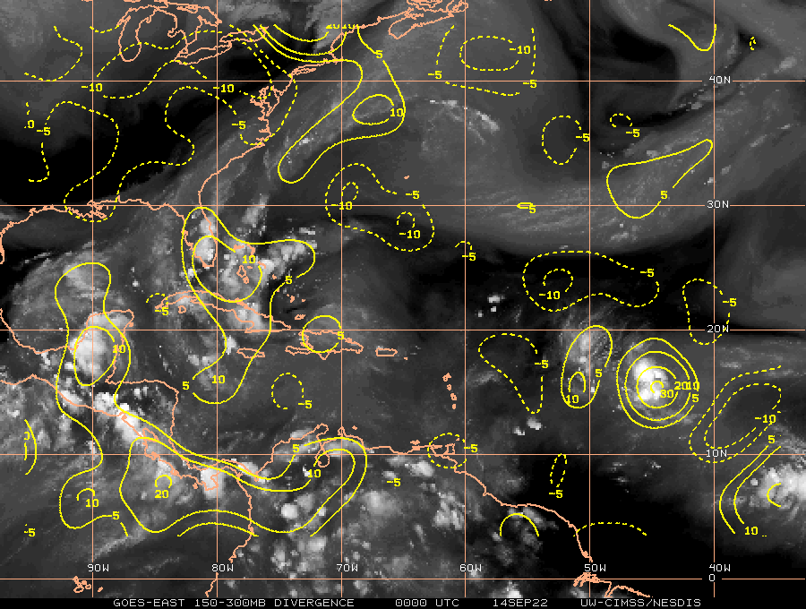

Convergence and divergence getting there.
0 likes
Go Giants! Go Niners! Go Warriors!
-
AutoPenalti
- Category 5
- Posts: 4091
- Age: 29
- Joined: Mon Aug 17, 2015 4:16 pm
- Location: Ft. Lauderdale, Florida
Re: ATL: INVEST 96L - Discussion
Well if the GFS ensembles are any indication, the stronger this becomes, the more OTS this goes.
0 likes
The posts in this forum are NOT official forecasts and should not be used as such. They are just the opinion of the poster and may or may not be backed by sound meteorological data. They are NOT endorsed by any professional institution or STORM2K. For official information, please refer to products from the NHC and NWS.
Model Runs Cheat Sheet:
GFS (5:30 AM/PM, 11:30 AM/PM)
HWRF, GFDL, UKMET, NAVGEM (6:30-8:00 AM/PM, 12:30-2:00 AM/PM)
ECMWF (1:45 AM/PM)
TCVN is a weighted averaged

Re: ATL: INVEST 96L - Discussion
skyline385 wrote:tiger_deF wrote:It says a great deal about how disappointing this season is that we have a convectively active wave in the MDR during peak season and the forum is nearly dead. Regardless, I think 96L has a decent chance of developing into a tropical storm over the next two days, and may surprise some people.
Well the wave became convectively active just a couple of hours ago, was pretty much dead throughout the day. Also, there is only so much people can get excited about a tropical wave
It's been convectively active since Monday night, with the exception of about five hours in the early afternoon when the two lobes of the wave started marging.
0 likes
The above post is not official and should not be used as such. It is the opinion of the poster and may or may not be backed by sound meteorological data. It is not endorsed by any professional institution or storm2k.org. For official information, please refer to the NHC and NWS products.

-
cycloneye

- Admin

- Posts: 149505
- Age: 69
- Joined: Thu Oct 10, 2002 10:54 am
- Location: San Juan, Puerto Rico
Re: ATL: INVEST 96L - Discussion
Tropical Weather Outlook
NWS National Hurricane Center Miami FL
200 AM EDT Wed Sep 14 2022
For the North Atlantic...Caribbean Sea and the Gulf of Mexico:
1. Central Tropical Atlantic:
Showers and thunderstorms have increased a little during the past
several hours in association with a tropical wave located a little
less than 900 miles east of the Lesser Antilles. Although
environmental conditions are only marginally conducive, some
additional development of this system is possible and a tropical
depression could form during the next couple of days. This system
is expected to moves westward to west-northwestward over the
tropical Atlantic and it is expected to be near the Leeward Islands
on Friday. Interests in the Leeward Islands, the Virgin Islands, and
Puerto Rico should monitor the progress of this system.
* Formation chance through 48 hours...medium...40 percent.
* Formation chance through 5 days...medium...50 percent.
Forecaster Cangialosi
0 likes
Visit the Caribbean-Central America Weather Thread where you can find at first post web cams,radars
and observations from Caribbean basin members Click Here
and observations from Caribbean basin members Click Here
-
Sciencerocks
- Category 5
- Posts: 10186
- Age: 40
- Joined: Thu Jul 06, 2017 1:51 am

-
Dean4Storms
- S2K Supporter
- Posts: 6358
- Age: 63
- Joined: Sun Aug 31, 2003 1:01 pm
- Location: Miramar Bch. FL

Re: ATL: INVEST 96L - Discussion
wxman57 wrote:Appears to be mainly a rain threat for the islands of the NE Caribbean Fri-Sun. Won't matter if it's called a TD or a disturbance, the threat is heavy rain. Lots of model divergence beyond the next 2-3 days. GFS indicates it is moving right into the southern edge of a strong TUTT. There's a fine line between good ventilation and wind shear. 300-700mb moisture is strung out to the east of the weak low in both the GFS & Euro this weekend, indicating shear.
The 00Z GEM got insulted by the model divergence comment and tracked into Houston.
Several 00z models including GFS show climo solutions weak and west into the Caribbean.
Looks like the center is slowly organizing and gaining latitude where it will be more likely to feel the ventilation/shear from the forecast TUTT. 00Z HWRF seems to respond positively to the ventilation before it becomes shear.
1 likes

Re: ATL: INVEST 96L - Discussion
Wow, this looks fantastic, like it’s already a TC. Can’t wait for all the convection to collapse again this morning lol
0 likes
Irene '11 Sandy '12 Hermine '16 5/15/2018 Derecho Fay '20 Isaias '20 Elsa '21 Henri '21 Ida '21
I am only a meteorology enthusiast who knows a decent amount about tropical cyclones. Look to the professional mets, the NHC, or your local weather office for the best information.
I am only a meteorology enthusiast who knows a decent amount about tropical cyclones. Look to the professional mets, the NHC, or your local weather office for the best information.
Re: ATL: INVEST 96L - Discussion
aspen wrote:Wow, this looks fantastic, like it’s already a TC. Can’t wait for all the convection to collapse again this morning lol
Looked to me like the center might outrun the convection earlier this morning.
The center is on the western periphery of the tilted CDO at sunrise.
0 likes

Re: ATL: INVEST 96L - Discussion
Dean4Storms wrote:Looks like a TD this morning.
The NHC will not go from orange to TD unless landfall is imminent.
We will likely see the red "tomato" later today. Unless miraculously ASCAT gets the center or the visible satellite is very impressive the NHC will be conservative...updating the chances by 10 to 20% every 6 hours.
TD tomorrow most likely if it continues to improve. Theres an outside chance this gets updated at 5pm or 11pm but I doubt it.
3 likes
-
Iceresistance

- Category 5
- Posts: 9592
- Age: 22
- Joined: Sat Oct 10, 2020 9:45 am
- Location: Tecumseh, OK/Norman, OK
Re: ATL: INVEST 96L - Discussion
DorkyMcDorkface wrote:DorkyMcDorkface wrote:Convectively it definitely looks better than what models had at this point in time but we need to see if it maintains into the morning rather than collapse like it did today. Also would be nice to get an ASCAT pass.
...annnnnnnnd it missed lol, of course.
I swear it's more inaccurate than a stormtrooper.
https://i.ibb.co/YTh2bB3/20220914-0037-mtb-ASCAT-wind-96-L-INVEST-25kts-1010mb-155-N-466-W-25km.jpg
It did, however, pick up the eastern side of the wind field and found some of 25 knot barbs.
0 likes
Bill 2015 & Beta 2020
Winter 2020-2021
All observations are in Tecumseh, OK unless otherwise noted.
Winter posts are focused mainly for Oklahoma & Texas.
Take any of my forecasts with a grain of salt, refer to the NWS, SPC, and NHC for official information
Never say Never with weather! Because ANYTHING is possible!
Winter 2020-2021
All observations are in Tecumseh, OK unless otherwise noted.
Winter posts are focused mainly for Oklahoma & Texas.
Take any of my forecasts with a grain of salt, refer to the NWS, SPC, and NHC for official information
Never say Never with weather! Because ANYTHING is possible!
-
Blown Away

- S2K Supporter
- Posts: 10253
- Joined: Wed May 26, 2004 6:17 am
Re: ATL: INVEST 96L - Discussion


Latest... Definite improvement from yesterday.
2 likes
Hurricane Eye Experience: David 79, Irene 99, Frances 04, Jeanne 04, Wilma 05… Hurricane Brush Experience: Andrew 92, Erin 95, Floyd 99, Matthew 16, Irma 17, Ian 22, Nicole 22…
-
toad strangler

- S2K Supporter
- Posts: 4546
- Joined: Sun Jul 28, 2013 3:09 pm
- Location: Earth
- Contact:
Re: ATL: INVEST 96L - Discussion
96L is surviving and puttering along ...
0 likes
My Weather Station
https://www.wunderground.com/dashboard/pws/KFLPORTS603
https://www.wunderground.com/dashboard/pws/KFLPORTS603
Who is online
Users browsing this forum: No registered users and 32 guests