ATL: IAN - Models

Moderator: S2k Moderators

Message
Author
utweather
Category 1
Category 1
Posts: 252
Joined: Tue Jan 26, 2010 10:51 pm
Location: SE Austin, TX

Re: ATL: INVEST 98L - Models

#661 Postby utweather » Thu Sep 22, 2022 12:45 am

PTrackerLA wrote:
IcyTundra wrote:
Cpv17 wrote:
In late September? Highly doubt it. Not impossible but damn near it.


I agree if this was happening a month earlier or even 2 weeks ago it would be a bigger threat to Texas but with it being late September I don't see it happening. Rita came close to being a rare late September hit and there is a few others I'm forgetting but it is highly unlikely imo.


Hurricane Delta made landfall about 50 miles east of the TX/LA border on 10/10/2020. Also interesting to note, Hurricane Lili made landfall roughly 60 miles west of the 00z landfall point 20 years ago minus 1 day on October 3, 2002.


Definitely keep an eye on this in Texas. The almanac is not foolproof.
4 likes   

LarryWx
S2K Supporter
S2K Supporter
Posts: 6305
Joined: Sun Sep 07, 2003 2:04 pm
Location: GA

Re: ATL: INVEST 98L - Models

#662 Postby LarryWx » Thu Sep 22, 2022 1:23 am

0Z GEFS mean is the furthest west of any recent run.
1 likes   
Personal Forecast Disclaimer:
The posts in this forum are NOT official forecasts and should not be used as such. They are just the opinion of the poster and may or may not be backed by sound meteorological data. They are NOT endorsed by any professional institution or storm2k.org. For official information, please refer to the NHC and NWS products.

User avatar
SoupBone
Category 5
Category 5
Posts: 3111
Joined: Tue Sep 20, 2005 5:24 pm

Re: ATL: INVEST 98L - Models

#663 Postby SoupBone » Thu Sep 22, 2022 1:26 am

LarryWx wrote:0Z GEFS mean is the furthest west of any recent run.


Yeah with quite a few ensemble members meandering around the bay of campeche. I'm not understanding that.
0 likes   
Personal Forecast Disclaimer:
The posts in this forum are NOT official forecast and should not be used as such. They are just the opinion of the poster and may or may not be backed by sound meteorological data. They are NOT endorsed by any professional institution or storm2k.org. For official information, please refer to the NHC and NWS products.

User avatar
Teban54
Category 5
Category 5
Posts: 3204
Joined: Sat May 19, 2018 1:19 pm

Re: ATL: INVEST 98L - Models

#664 Postby Teban54 » Thu Sep 22, 2022 1:26 am

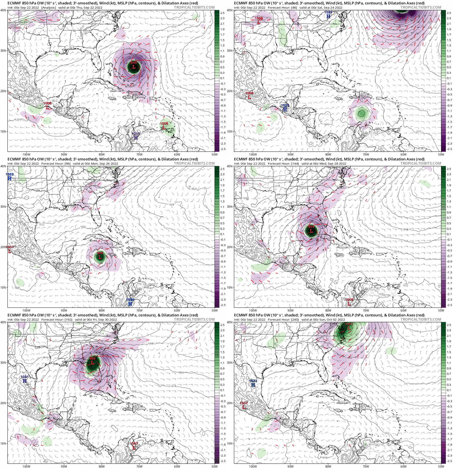
0z Euro is much stronger and faster in the short term. As a result, at 120 hrs (0z 9/27) its location and intensity are virtually the same as 12z run's 12z 9/27. Still the same track so far.
1 likes   

Keldeo1997
Category 2
Category 2
Posts: 637
Joined: Fri Oct 11, 2019 11:35 pm

Re: ATL: INVEST 98L - Models

#665 Postby Keldeo1997 » Thu Sep 22, 2022 1:30 am

Image

Strongest EURO run so far.
0 likes   

LarryWx
S2K Supporter
S2K Supporter
Posts: 6305
Joined: Sun Sep 07, 2003 2:04 pm
Location: GA

Re: ATL: INVEST 98L - Models

#666 Postby LarryWx » Thu Sep 22, 2022 1:35 am

0Z Euro is west of the 12Z and the 0Z of yesterday.
0 likes   
Personal Forecast Disclaimer:
The posts in this forum are NOT official forecasts and should not be used as such. They are just the opinion of the poster and may or may not be backed by sound meteorological data. They are NOT endorsed by any professional institution or storm2k.org. For official information, please refer to the NHC and NWS products.

Keldeo1997
Category 2
Category 2
Posts: 637
Joined: Fri Oct 11, 2019 11:35 pm

Re: ATL: INVEST 98L - Models

#667 Postby Keldeo1997 » Thu Sep 22, 2022 1:37 am

Image

Watch out Big bend :double:
0 likes   

CrazyC83
Professional-Met
Professional-Met
Posts: 34002
Joined: Tue Mar 07, 2006 11:57 pm
Location: Deep South, for the first time!

Re: ATL: INVEST 98L - Models

#668 Postby CrazyC83 » Thu Sep 22, 2022 1:37 am

The 00Z Euro has basically gone back to what it was a couple days ago. A nightmare scenario for Tampa Bay.
2 likes   

User avatar
AtlanticWind
S2K Supporter
S2K Supporter
Posts: 1888
Age: 66
Joined: Sun Aug 08, 2004 9:57 pm
Location: Plantation,Fla

Re: ATL: INVEST 98L - Models

#669 Postby AtlanticWind » Thu Sep 22, 2022 1:40 am

At 7 days euro just off of tampa , Gfs in middle of gulf
Pretty big difference

Gfs kinda the outlier from euro ,ukmet, Canadian. We shall see who ends up right.
0 likes   

shah83
Category 1
Category 1
Posts: 302
Joined: Sun Jul 31, 2016 4:55 pm

Re: ATL: INVEST 98L - Models

#670 Postby shah83 » Thu Sep 22, 2022 1:40 am

One thing I've been concerned about was that with models maybe generally being too far west, we've not really countenanced the post-Fl evolution of future Ian. Setup seems to favor a nasty Mid-Atlantic or NE impact.
0 likes   

caneman
Category 5
Category 5
Posts: 1447
Joined: Fri Sep 05, 2014 5:44 am
Location: Clearwater Beach, Fl

Re: ATL: INVEST 98L - Models

#671 Postby caneman » Thu Sep 22, 2022 1:40 am

CrazyC83 wrote:The 00Z Euro has basically gone back to what it was a couple days ago. A nightmare scenario for Tampa Bay.


Yep that's the angle of approach and just North of us that would cause the most damage other than right up the bay.
Last edited by caneman on Thu Sep 22, 2022 1:40 am, edited 1 time in total.
0 likes   

User avatar
SoupBone
Category 5
Category 5
Posts: 3111
Joined: Tue Sep 20, 2005 5:24 pm

Re: ATL: INVEST 98L - Models

#672 Postby SoupBone » Thu Sep 22, 2022 1:40 am

CrazyC83 wrote:The 00Z Euro has basically gone back to what it was a couple days ago. A nightmare scenario for Tampa Bay.


While the GFS has gone bonkers to the west into SE Louisiana.
0 likes   
Personal Forecast Disclaimer:
The posts in this forum are NOT official forecast and should not be used as such. They are just the opinion of the poster and may or may not be backed by sound meteorological data. They are NOT endorsed by any professional institution or storm2k.org. For official information, please refer to the NHC and NWS products.

User avatar
Blown Away
S2K Supporter
S2K Supporter
Posts: 10145
Joined: Wed May 26, 2004 6:17 am

Re: ATL: INVEST 98L - Models

#673 Postby Blown Away » Thu Sep 22, 2022 1:48 am

00z Euro holds serve, slightly N of 12z FL landfall. At 192 hours the GFS is 600+ miles SW of Euro, crazy!
0 likes   
Hurricane Eye Experience: David 79, Irene 99, Frances 04, Jeanne 04, Wilma 05... EYE COMING MY WAY IN 2024…
Hurricane Brush Experience: Andrew 92, Erin 95, Floyd 99, Matthew 16, Irma 17, Ian 22, Nicole 22…

Jelmergraaff
Tropical Storm
Tropical Storm
Posts: 137
Age: 22
Joined: Fri Aug 27, 2021 1:00 pm
Location: The Netherlands

Re: ATL: INVEST 98L - Models

#674 Postby Jelmergraaff » Thu Sep 22, 2022 1:51 am

HWRF has it intensifying quickly over the NW-Carribean with an increase from 996mb/42kt to 935mb/120kt in just 48 hours. Takes it right in between Cuba and the Yucutan it seems.

0 likes   
21-year old meteorologist and student MSc Climate Studies from The Netherlands. Interested in all fields of meteorology and climatology, including tropical systems like hurricanes.

User avatar
Blown Away
S2K Supporter
S2K Supporter
Posts: 10145
Joined: Wed May 26, 2004 6:17 am

Re: ATL: INVEST 98L - Models

#675 Postby Blown Away » Thu Sep 22, 2022 1:58 am

Image
00z ECMWF… FL landfall just N of Tampa then accelerates NE, no stall like 12z.
0 likes   
Hurricane Eye Experience: David 79, Irene 99, Frances 04, Jeanne 04, Wilma 05... EYE COMING MY WAY IN 2024…
Hurricane Brush Experience: Andrew 92, Erin 95, Floyd 99, Matthew 16, Irma 17, Ian 22, Nicole 22…

User avatar
Blown Away
S2K Supporter
S2K Supporter
Posts: 10145
Joined: Wed May 26, 2004 6:17 am

Re: ATL: INVEST 98L - Models

#676 Postby Blown Away » Thu Sep 22, 2022 2:01 am

Image
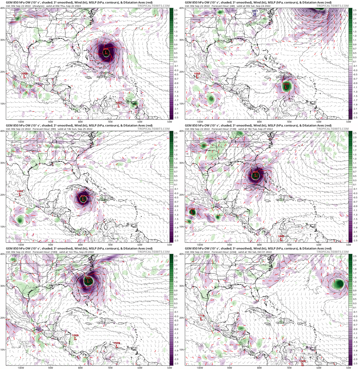
00z CMC… Big shift E with FL landfall near Everglades and accelerates NE.
Last edited by Blown Away on Thu Sep 22, 2022 2:16 am, edited 1 time in total.
0 likes   
Hurricane Eye Experience: David 79, Irene 99, Frances 04, Jeanne 04, Wilma 05... EYE COMING MY WAY IN 2024…
Hurricane Brush Experience: Andrew 92, Erin 95, Floyd 99, Matthew 16, Irma 17, Ian 22, Nicole 22…

hurricaneCW
Category 5
Category 5
Posts: 1794
Joined: Wed Mar 03, 2010 6:20 am
Location: Toms River, NJ

Re: ATL: INVEST 98L - Models

#677 Postby hurricaneCW » Thu Sep 22, 2022 2:06 am

I think something between the CMC & Euro is most likely. GFS is way out there but not impossible if it takes a while to develop.
0 likes   

User avatar
Blown Away
S2K Supporter
S2K Supporter
Posts: 10145
Joined: Wed May 26, 2004 6:17 am

Re: ATL: INVEST 98L - Models

#678 Postby Blown Away » Thu Sep 22, 2022 2:12 am

Image

Image


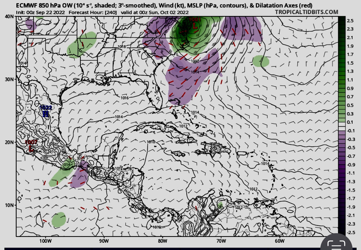
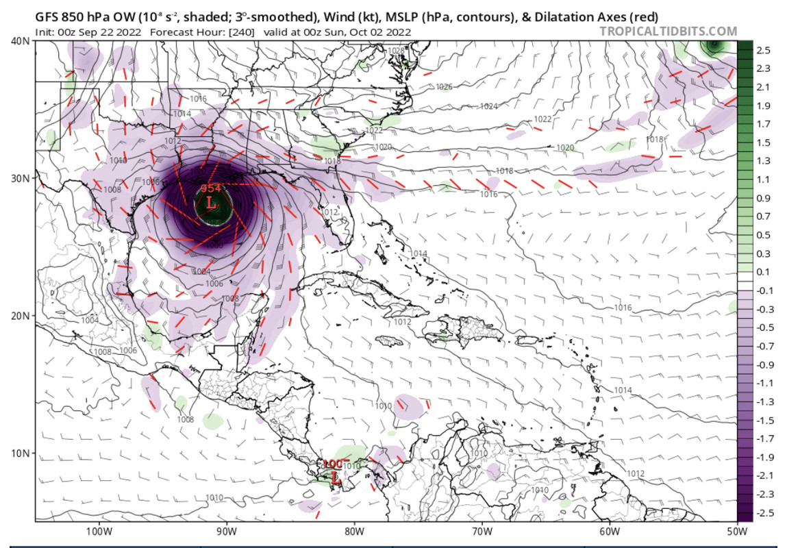
For fun, the 00z GFS/EURO at 240 hours are @1200 miles apart! In addition to this craziness, the EURO is E outlier and GFS is W outlier. Interested to see how this resolves!
3 likes   
Hurricane Eye Experience: David 79, Irene 99, Frances 04, Jeanne 04, Wilma 05... EYE COMING MY WAY IN 2024…
Hurricane Brush Experience: Andrew 92, Erin 95, Floyd 99, Matthew 16, Irma 17, Ian 22, Nicole 22…

LarryWx
S2K Supporter
S2K Supporter
Posts: 6305
Joined: Sun Sep 07, 2003 2:04 pm
Location: GA

Re: ATL: INVEST 98L - Models

#679 Postby LarryWx » Thu Sep 22, 2022 3:06 am

0Z EPS mean seems to be similar to the 12Z. The spread seems a bit tighter (fewer extremes like Yucatan and Bahamas).
0 likes   
Personal Forecast Disclaimer:
The posts in this forum are NOT official forecasts and should not be used as such. They are just the opinion of the poster and may or may not be backed by sound meteorological data. They are NOT endorsed by any professional institution or storm2k.org. For official information, please refer to the NHC and NWS products.

User avatar
Ivanhater
Storm2k Moderator
Storm2k Moderator
Posts: 11161
Age: 38
Joined: Fri Jul 01, 2005 8:25 am
Location: Pensacola

Re: ATL: INVEST 98L - Models

#680 Postby Ivanhater » Thu Sep 22, 2022 3:08 am

Blend has been pretty consistent


Image

Sent from my LM-G900TM using Tapatalk
0 likes   
Michael


Return to “2022”

Who is online

Users browsing this forum: No registered users and 17 guests