936
WTPZ31 KNHC 020850
TCPEP1
BULLETIN
Hurricane Orlene Advisory Number 15
NWS National Hurricane Center Miami FL EP162022
300 AM MDT Sun Oct 02 2022
...ORLENE RAPIDLY STRENGTHENS INTO A CATEGORY 4 HURRICANE...
SUMMARY OF 300 AM MDT...0900 UTC...INFORMATION
----------------------------------------------
LOCATION...19.0N 106.8W
ABOUT 120 MI...195 KM SW OF CABO CORRIENTES MEXICO
ABOUT 175 MI...280 KM S OF LAS ISLAS MARIAS MEXICO
MAXIMUM SUSTAINED WINDS...130 MPH...215 KM/H
PRESENT MOVEMENT...N OR 5 DEGREES AT 7 MPH...11 KM/H
MINIMUM CENTRAL PRESSURE...949 MB...28.03 INCHES
WATCHES AND WARNINGS
--------------------
CHANGES WITH THIS ADVISORY:
None.
SUMMARY OF WATCHES AND WARNINGS IN EFFECT:
A Hurricane Warning is in effect for...
* Las Islas Marias
* The coast of mainland Mexico from San Blas to Mazatlan
A Tropical Storm Warning is in effect for...
* The coast of mainland Mexico from Playa Perula to San Blas
A Hurricane Watch is in effect for...
* The coast of mainland Mexico from Playa Perula to San Blas
* The coast of mainland Mexico from Mazatlan to Bahia Tempehuaya
A Tropical Storm Watch is in effect for...
* The coast of mainland Mexico from Manzanillo to Playa Perula
A Hurricane Warning means that hurricane conditions are expected
somewhere within the warning area. A warning is typically issued
36 hours before the anticipated first occurrence of
tropical-storm-force winds, conditions that make outside
preparations difficult or dangerous. Preparations to protect life
and property should be rushed to completion.
A Tropical Storm Warning means that tropical storm conditions are
expected somewhere within the warning area, generally within 36
hours.
A Hurricane Watch means that hurricane conditions are possible
within the watch area. A watch is typically issued 48 hours
before the anticipated first occurrence of tropical-storm-force
winds, conditions that make outside preparations difficult or
dangerous.
A Tropical Storm Watch means that tropical storm conditions are
possible within the watch area, generally within 48 hours.
Interests elsewhere along the coast of western and northwestern
Mexico should monitor the progress of Orlene. Additional watches or
warnings could be required for portions of these areas on Sunday.
For storm information specific to your area, please monitor
products issued by your national meteorological service.
----
Hurricane Orlene Discussion Number 15
NWS National Hurricane Center Miami FL EP162022
300 AM MDT Sun Oct 02 2022
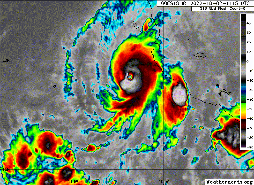
Orlene has continued to strengthen rapidly over the past several
hours. On GOES-17 satellite imagery, the system has a
well-defined eye with a temperature near -4 deg C surrounded by
very cold tops to near -80 deg C, particularly over the western
eyewall. Based on objective T-numbers from UW-CIMSS, the current
intensity estimate is raised to 115 kt. Subjective Dvorak
estimates are somewhat lower, but these are constrained by the rules
of the technique. Over the 15-h period from 1800 UTC yesterday to
the time of this advisory, the intensity of the hurricane has
increased by an estimated 40 kt. Orlene remains a small tropical
cyclone, with its destructive core covering an area some 20 n mi in
diameter. The system continues to exhibit strong upper-level
outflow with an outflow jet noted over the northern part of the
circulation.
In the short term, environmental conditions are expected to be
conducive for further strengthening, with moderate vertical shear
prevailing for the next 12 hours or so. Thereafter, although
thermodynamic factors should remain conducive, the global models
show a substantial increase in southwesterly vertical shear over
the hurricane. This is also suggested by water vapor imagery which
depicts a broad upper-level trough north of 20N and west of the
Baja California peninsula. Since Orlene is a small hurricane, it
should be especially susceptible to the negative effects of the
increasing shear. Therefore a weakening trend is predicted to
begin after 12 hours. Nonetheless, given Orlene's recent
strengthening , the official intensity forecast is above all of
the model guidance. It is anticipated that the system will be at
or near hurricane strength when it reaches the coast of mainland
Mexico. After landfall, the cyclone will quickly weaken over the
mountainous terrain.
Orlene continues moving northward or at about 005/6 kt. During
the next 48 hours or so, the hurricane should be steered by the
flow between the mid/upper-level trough near Baja California and
northwestern Mexico and a subtropical ridge to its east. A slight
bend of the heading toward the north-northeast is likely later
today. The official forecast track is very close to the previous
NHC track, and is a little to the east of the dynamical model
consensus. The GFS model is significantly farther to the right and
faster than the other track guidance.
Key Messages:
1. Hurricane conditions are expected in the Islas Marias tonight,
with tropical storm conditions beginning later today. A Hurricane
Warning is in effect for a portion of west-central mainland Mexico,
where hurricane conditions are expected on Monday with tropical
storm conditions beginning early Monday. Preparations to protect
life and property should be rushed to completion.
2. Heavy rainfall from Orlene is expected to lead to flash flooding,
as well as possible landslides in areas of rugged terrain of
southwestern Mexico into Tuesday.
FORECAST POSITIONS AND MAX WINDS
INIT 02/0900Z 19.0N 106.8W 115 KT 130 MPH
12H 02/1800Z 19.7N 106.6W 125 KT 145 MPH
24H 03/0600Z 20.9N 106.3W 105 KT 120 MPH
36H 03/1800Z 22.0N 106.0W 85 KT 100 MPH
48H 04/0600Z 22.8N 105.7W 65 KT 75 MPH...INLAND
60H 04/1800Z 23.2N 105.4W 40 KT 45 MPH...INLAND
72H 05/0600Z...DISSIPATED
$$
Forecaster Pasch