Nothing here to see for now. Lets keep it that way.
https://twitter.com/TropicalTidbits/status/1576949215712129027
EPAC: JULIA - Remnants - Discussion
Moderator: S2k Moderators
-
SFLcane

- S2K Supporter

- Posts: 9615
- Age: 46
- Joined: Sat Jun 05, 2010 1:44 pm
- Location: Lake Worth Florida
Re: ATL: INVEST 91L - Discussion
1 likes
-
Sciencerocks
- Category 5

- Posts: 7287
- Age: 38
- Joined: Thu Jul 06, 2017 1:51 am
Re: ATL: INVEST 91L - Discussion
Sailingtime wrote:ConvergenceZone wrote:kevin wrote:Another Caribbean cruiser, here we go again. As per tradition with these sort of invests on storm2k, here's my post saying 'this is gonna be a long thread'.
It will only be a long thread if it ends up being a USA threat, otherwise, probably a fairly short thread..........Not to mention when you have such a monster that Ian was, it takes alot out of people, so there's that factor as well.......
I'm in central Florida and came out pretty much OK with Ian. That said, I'm drained from both tracking the storm, preparing for the storm, going through the storm and cleaning up after the storm. Like most on here, I enjoy keeping tabs and tracking the tropics but Ian when it comes knocking on your neighborhood it's an entirely different experience. Mark me down as hoping for a peaceful October and November.
Man, I feel you on that my friend. I'm all for blue skies and a gentle breeze to keep yall cool during the aftermath, it's exhausting and challenging to say the least, 2 of my brothers are on their way to Florida to spend 2 weeks, doing what they can, where they can, to be of help with whatever they can help with. I wanted to go as well, but our youngest sister is at MD Anderson cancer center, not feeling too well, so I'm with her, doing what I need to do to lift her up....anyways, peace to all yall, I wish the best for each and everyone of you, affected by Ian....
10 likes
-
tropicwatch

- Category 5
- Posts: 3205
- Age: 60
- Joined: Sat Jun 02, 2007 10:01 am
- Location: Panama City Florida
- Contact:
Re: ATL: INVEST 91L - Discussion
Looks like AF is moving aircraft towards the Caribbean. Three non-tasked missions heading that way now.
2 likes
Tropicwatch
Agnes 72', Eloise 75, Elena 85', Kate 85', Charley 86', Florence 88', Beryl 94', Dean 95', Erin 95', Opal 95', Earl 98', Georges 98', Ivan 2004', Arlene 2005', Dennis 2005', Ida 2009' Debby 2012' Irma 2017' Michael 2018'
Agnes 72', Eloise 75, Elena 85', Kate 85', Charley 86', Florence 88', Beryl 94', Dean 95', Erin 95', Opal 95', Earl 98', Georges 98', Ivan 2004', Arlene 2005', Dennis 2005', Ida 2009' Debby 2012' Irma 2017' Michael 2018'

-
Category5Kaiju

- Category 5
- Posts: 3379
- Age: 22
- Joined: Thu Dec 24, 2020 12:45 pm
- Location: Seattle
Re: ATL: INVEST 91L - Discussion
Teban54 wrote:And the hype died off real quick...
How much you want to bet that this reduction in convection is only temporary and that it is going to blow up in convection again at some point, making people excited again?
3 likes
Unless explicitly stated, all information covered in my posts is based on my opinions and observations. Please refer to a professional meteorologist or an accredited weather research agency otherwise, especially if serious decisions must be made in the event of a potentially life-threatening tropical storm or hurricane.
-
ElectricStorm

- Category 5
- Posts: 4593
- Age: 23
- Joined: Tue Aug 13, 2019 11:23 pm
- Location: Skiatook, OK / Norman, OK
Re: ATL: INVEST 91L - Discussion
An invest with decent spin entering one of the most prime October development areas in the entire basin...
Yeah I think this develops regardless of what the models are showing at this point. I think the models will probably return to showing development again pretty soon.
There's always a chance it doesn't ever get going of course, but I would be surprised if we don't at least get a TS out of this.
Yeah I think this develops regardless of what the models are showing at this point. I think the models will probably return to showing development again pretty soon.
There's always a chance it doesn't ever get going of course, but I would be surprised if we don't at least get a TS out of this.
3 likes
I am in no way a professional. Take what I say with a grain of salt as I could be totally wrong. Please refer to the NHC, NWS, or SPC for official information.
Boomer Sooner!
Boomer Sooner!

Re: ATL: INVEST 91L - Discussion
I’m leaning towards no development. The wave looks way less organized today than yesterday, and that ULL will start shearing it in just a few days. If there isn’t a TC before the Lesser Antilles, then 91L could be ripped apart like the GFS/Euro show, regardless of what conditions await for it west of 65-70W.
1 likes
Irene '11 Sandy '12 Hermine '16 5/15/2018 Derecho Fay '20 Isaias '20 Elsa '21 Henri '21 Ida '21
I am only a meteorology enthusiast who knows a decent amount about tropical cyclones. Look to the professional mets, the NHC, or your local weather office for the best information.
I am only a meteorology enthusiast who knows a decent amount about tropical cyclones. Look to the professional mets, the NHC, or your local weather office for the best information.
-
weeniepatrol

- Category 3

- Posts: 864
- Joined: Sat Aug 22, 2020 5:30 pm
- Location: WA State
Re: ATL: INVEST 91L - Discussion
aspen wrote:I’m leaning towards no development. The wave looks way less organized today than yesterday, and that ULL will start shearing it in just a few days. If there isn’t a TC before the Lesser Antilles, then 91L could be ripped apart like the GFS/Euro show, regardless of what conditions await for it west of 65-70W.
This post makes me bullish
16 likes
-
ElectricStorm
- Category 5
- Posts: 4593
- Age: 23
- Joined: Tue Aug 13, 2019 11:23 pm
- Location: Skiatook, OK / Norman, OK
Re: ATL: INVEST 91L - Discussion
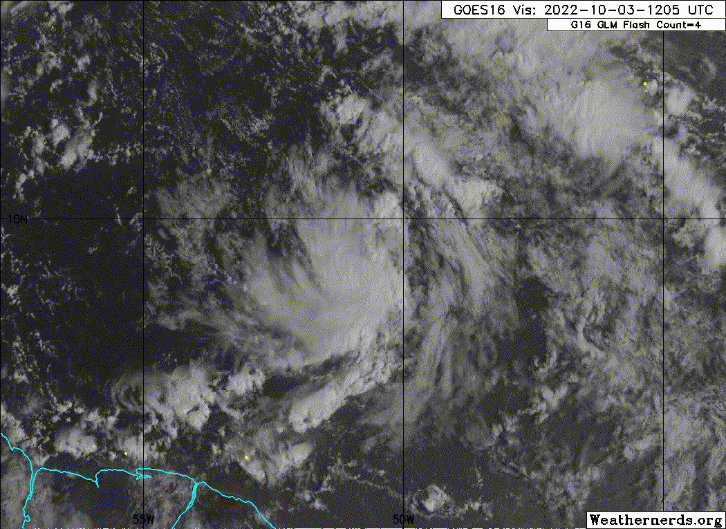
2. East of the Windward Islands:
Showers and thunderstorms associated with a tropical wave located
several hundred miles east of the southern Windward Islands have
changed little in organization during the last several hours. Slow
development is possible during the next several days while the wave
moves generally westward at 15 to 20 mph, reaching the Windward
Islands and the eastern Caribbean Sea by midweek. Interests in the
Windward Islands should monitor the progress of the system.
* Formation chance through 48 hours...low...20 percent.
* Formation chance through 5 days...low...30 percent.
2 likes
I am in no way a professional. Take what I say with a grain of salt as I could be totally wrong. Please refer to the NHC, NWS, or SPC for official information.
Boomer Sooner!
Boomer Sooner!
-
chris_fit

- Category 5
- Posts: 3078
- Joined: Wed Sep 10, 2003 11:58 pm
- Location: Tampa Bay Area, FL
- Contact:
Re: ATL: INVEST 91L - Discussion
Think this thread is going to poof as quickly as 91L did today.
3 likes
-
ElectricStorm
- Category 5
- Posts: 4593
- Age: 23
- Joined: Tue Aug 13, 2019 11:23 pm
- Location: Skiatook, OK / Norman, OK
Re: ATL: INVEST 91L - Discussion
Convection to the south is starting to rapidly expand closer to the center. We'll see if it can sustain better than the last round
2 likes
I am in no way a professional. Take what I say with a grain of salt as I could be totally wrong. Please refer to the NHC, NWS, or SPC for official information.
Boomer Sooner!
Boomer Sooner!
-
Category5Kaiju
- Category 5
- Posts: 3379
- Age: 22
- Joined: Thu Dec 24, 2020 12:45 pm
- Location: Seattle
Re: ATL: INVEST 91L - Discussion
Is it October? Yes
Is the Caribbean warmer than average? Yes
Do we have an Atlantic Nino? No
With how models this year seem to love latching onto development merely days out and with this taking a climatologically very favorable route, I gotta say, I'm not throwing in the towel *just* yet. Who knows if this could develop in the WCAR instead, much like Eta or Iota did? Many questions still remain, and the best thing to do is to track live time and wait.
0 likes
Unless explicitly stated, all information covered in my posts is based on my opinions and observations. Please refer to a professional meteorologist or an accredited weather research agency otherwise, especially if serious decisions must be made in the event of a potentially life-threatening tropical storm or hurricane.
-
CrazyC83
- Professional-Met

- Posts: 33393
- Joined: Tue Mar 07, 2006 11:57 pm
- Location: Deep South, for the first time!
Re: ATL: INVEST 91L - Discussion
I believe the Recon mission ongoing now is a repositioning mission to move planes to St. Croix to cover this storm, since that will be their base initially. I believe once west of 80W in the Caribbean, they would fly out of Biloxi.
3 likes

Re: ATL: INVEST 91L - Discussion
Yeah, I think after Ian I will just watch this feature as it develops (or doesn't) and not even care to look beyond 48 hrs for modeling. Straight to nowcasting 
3 likes
Andrew (1992), Irene (1999), Frances (2004), Katrina (2005), Wilma (2005), Fay (2008), Irma (2017), Eta (2020), Ian (2022)
-
cycloneye

- Admin

- Posts: 139212
- Age: 67
- Joined: Thu Oct 10, 2002 10:54 am
- Location: San Juan, Puerto Rico
Re: ATL: INVEST 91L - Discussion
3 likes
Visit the Caribbean-Central America Weather Thread where you can find at first post web cams,radars
and observations from Caribbean basin members Click Here
and observations from Caribbean basin members Click Here
-
cycloneye
- Admin
- Posts: 139212
- Age: 67
- Joined: Thu Oct 10, 2002 10:54 am
- Location: San Juan, Puerto Rico
Re: ATL: INVEST 91L - Discussion
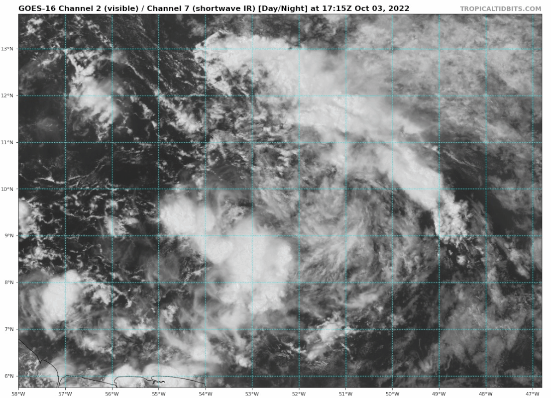
East of the Windward Islands:
A tropical wave located a few hundred miles east of the southern
Windward Islands is producing disorganized showers and
thunderstorms. Slow development is possible during the next several
days while the wave moves generally westward at 15 to 20 mph,
reaching the Windward Islands and the eastern Caribbean Sea by
midweek and the western Caribbean over the weekend. Interests in
the Windward Islands should monitor the progress of this system.
* Formation chance through 48 hours...low...20 percent.
* Formation chance through 5 days...low...30 percent.
0 likes
Visit the Caribbean-Central America Weather Thread where you can find at first post web cams,radars
and observations from Caribbean basin members Click Here
and observations from Caribbean basin members Click Here
-
galaxy401

- Category 5
- Posts: 2299
- Age: 28
- Joined: Sat Aug 25, 2012 9:04 pm
- Location: Casa Grande, Arizona
Re: ATL: INVEST 91L - Discussion
I still feel like the odds should be a little higher despite the low model support at the moment. A rotation is evident, just needs more convection.
1 likes
Got my eyes on moving right into Hurricane Alley: Florida.

Re: ATL: INVEST 91L - Discussion
Looks like it's building some convection and starting to get that look .The waters in this area is pretty warm,looking for 91L to explode .
1 likes
Who is online
Users browsing this forum: No registered users and 24 guests