ATL: KARL - Models
Moderator: S2k Moderators
-
tropicwatch

- Category 5

- Posts: 3427
- Age: 62
- Joined: Sat Jun 02, 2007 10:01 am
- Location: The Villages, Florida
- Contact:
ATL: KARL - Models
0 likes
Tropicwatch
Agnes 72', Eloise 75, Elena 85', Kate 85', Charley 86', Florence 88', Beryl 94', Dean 95', Erin 95', Opal 95', Earl 98', Georges 98', Ivan 2004', Arlene 2005', Dennis 2005', Ida 2009' Debby 2012' Irma 2017' Michael 2018'
Agnes 72', Eloise 75, Elena 85', Kate 85', Charley 86', Florence 88', Beryl 94', Dean 95', Erin 95', Opal 95', Earl 98', Georges 98', Ivan 2004', Arlene 2005', Dennis 2005', Ida 2009' Debby 2012' Irma 2017' Michael 2018'


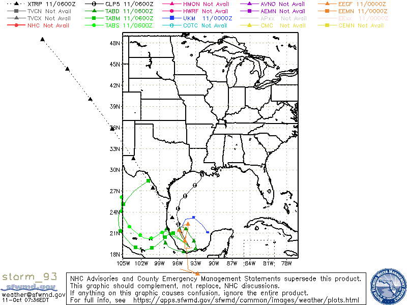
Re: ATL: INVEST 93L - Models
Salute!
Those things there this time of year concern we Panhandle folks.
Remember Opal 1995.
Gums sends...
Those things there this time of year concern we Panhandle folks.
Remember Opal 1995.
Gums sends...
5 likes
-
tropicwatch
- Category 5
- Posts: 3427
- Age: 62
- Joined: Sat Jun 02, 2007 10:01 am
- Location: The Villages, Florida
- Contact:
Re: ATL: INVEST 93L - Models
Gums wrote:Salute!
Those things there this time of year concern we Panhandle folks.
Remember Opal 1995.
Gums sends...
Hurt my back working that one.
0 likes
Tropicwatch
Agnes 72', Eloise 75, Elena 85', Kate 85', Charley 86', Florence 88', Beryl 94', Dean 95', Erin 95', Opal 95', Earl 98', Georges 98', Ivan 2004', Arlene 2005', Dennis 2005', Ida 2009' Debby 2012' Irma 2017' Michael 2018'
Agnes 72', Eloise 75, Elena 85', Kate 85', Charley 86', Florence 88', Beryl 94', Dean 95', Erin 95', Opal 95', Earl 98', Georges 98', Ivan 2004', Arlene 2005', Dennis 2005', Ida 2009' Debby 2012' Irma 2017' Michael 2018'

Re: ATL: INVEST 93L - Models
Forecast to go into Mexico not the panhandle the cold front is supposed to force it southward.
1 likes
-
chris_fit

- Category 5
- Posts: 3261
- Age: 43
- Joined: Wed Sep 10, 2003 11:58 pm
- Location: Tampa Bay Area, FL
Re: ATL: INVEST 93L - Models
boca wrote:Forecast to go into Mexico not the panhandle the cold front is supposed to force it southward.
Can someone explain this one? I always thought fronts/troughs 'picked up' storms not 'pushed' them further south (like a ridge.)
5 likes

Re: ATL: INVEST 93L - Models
12z GFS now gets a brief TS out of this.
0 likes
Irene '11 Sandy '12 Hermine '16 5/15/2018 Derecho Fay '20 Isaias '20 Elsa '21 Henri '21 Ida '21
I am only a meteorology enthusiast who knows a decent amount about tropical cyclones. Look to the professional mets, the NHC, or your local weather office for the best information.
I am only a meteorology enthusiast who knows a decent amount about tropical cyclones. Look to the professional mets, the NHC, or your local weather office for the best information.
Re: ATL: INVEST 93L - Models
The 12Z UKMET does nothing tropically with this, but it does have a well organized surface low that moves very slowly north til Thursday followed by a stall and subsequent drift south into MX. For the record, the 0Z UKMET had TCG at hour 36 and then moved slowly NE followed by a curve SE toward just off the NW tip of the Yucatan where it dissipated:
NEW TROPICAL CYCLONE FORECAST TO DEVELOP AFTER 36 HOURS
FORECAST POSITION AT T+ 36 : 21.9N 95.3W
LEAD CENTRAL MAXIMUM WIND
VERIFYING TIME TIME POSITION PRESSURE (MB) SPEED (KNOTS)
-------------- ---- -------- ------------- -------------
1200UTC 12.10.2022 36 21.9N 95.3W 1009 21
0000UTC 13.10.2022 48 23.0N 94.7W 1008 20
1200UTC 13.10.2022 60 23.2N 93.3W 1009 20
0000UTC 14.10.2022 72 22.2N 91.9W 1007 25
1200UTC 14.10.2022 84 21.1N 91.0W 1008 27
0000UTC 15.10.2022 96 CEASED TRACKING
1 likes
Personal Forecast Disclaimer:
The posts in this forum are NOT official forecasts and should not be used as such. They are just the opinion of the poster and may or may not be backed by sound meteorological data. They are NOT endorsed by any professional institution or storm2k.org. For official information, please refer to the NHC and NWS products.
The posts in this forum are NOT official forecasts and should not be used as such. They are just the opinion of the poster and may or may not be backed by sound meteorological data. They are NOT endorsed by any professional institution or storm2k.org. For official information, please refer to the NHC and NWS products.
Re: ATL: KARL - Models
Salute!
We Panhandle and LA/MS/AL folks have seen this before. It's one of the things that concerns us when the WX folks say the thing will meander about in BoC.
I hope some of the forecasts are correct and Karl will head west or even southwest and hit land.
Gums sends...
We Panhandle and LA/MS/AL folks have seen this before. It's one of the things that concerns us when the WX folks say the thing will meander about in BoC.
I hope some of the forecasts are correct and Karl will head west or even southwest and hit land.
Gums sends...
2 likes
Re: ATL: KARL - Models
UKMET formally had it back as a TC on 0Z run with SE movement til dissipation the last 24 hours:
TROPICAL STORM KARL ANALYSED POSITION : 20.6N 95.7W
ATCF IDENTIFIER : AL142022
LEAD CENTRAL MAXIMUM WIND
VERIFYING TIME TIME POSITION PRESSURE (MB) SPEED (KNOTS)
-------------- ---- -------- ------------- -------------
0000UTC 12.10.2022 0 20.6N 95.7W 1008 33
1200UTC 12.10.2022 12 21.7N 94.9W 1008 28
0000UTC 13.10.2022 24 22.2N 95.1W 1007 27
1200UTC 13.10.2022 36 22.3N 95.2W 1007 25
0000UTC 14.10.2022 48 21.5N 95.1W 1007 24
1200UTC 14.10.2022 60 20.3N 94.3W 1007 26
0000UTC 15.10.2022 72 19.7N 93.9W 1008 27
1200UTC 15.10.2022 84 CEASED TRACKING
0 likes
Personal Forecast Disclaimer:
The posts in this forum are NOT official forecasts and should not be used as such. They are just the opinion of the poster and may or may not be backed by sound meteorological data. They are NOT endorsed by any professional institution or storm2k.org. For official information, please refer to the NHC and NWS products.
The posts in this forum are NOT official forecasts and should not be used as such. They are just the opinion of the poster and may or may not be backed by sound meteorological data. They are NOT endorsed by any professional institution or storm2k.org. For official information, please refer to the NHC and NWS products.
-
wxman57

- Moderator-Pro Met

- Posts: 23175
- Age: 68
- Joined: Sat Jun 21, 2003 8:06 pm
- Location: Houston, TX (southwest)
Re: ATL: KARL - Models
Since there are concerns that Karl may be "picked up by the approaching front", let me explain why that won't happen.
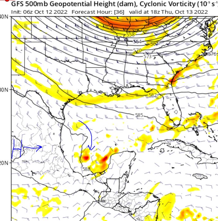
The front is not your typical NE-SW oriented cold front, it's more of an east-west oriented front. The primary steering current for Karl will be the ridge (500mb) that is building eastward across Mexico today. The ridge will steer Karl southward into southern Mexico. You can see the ridge building east on the image below:
http://wxman57.com/images/Karl500mb.JPG
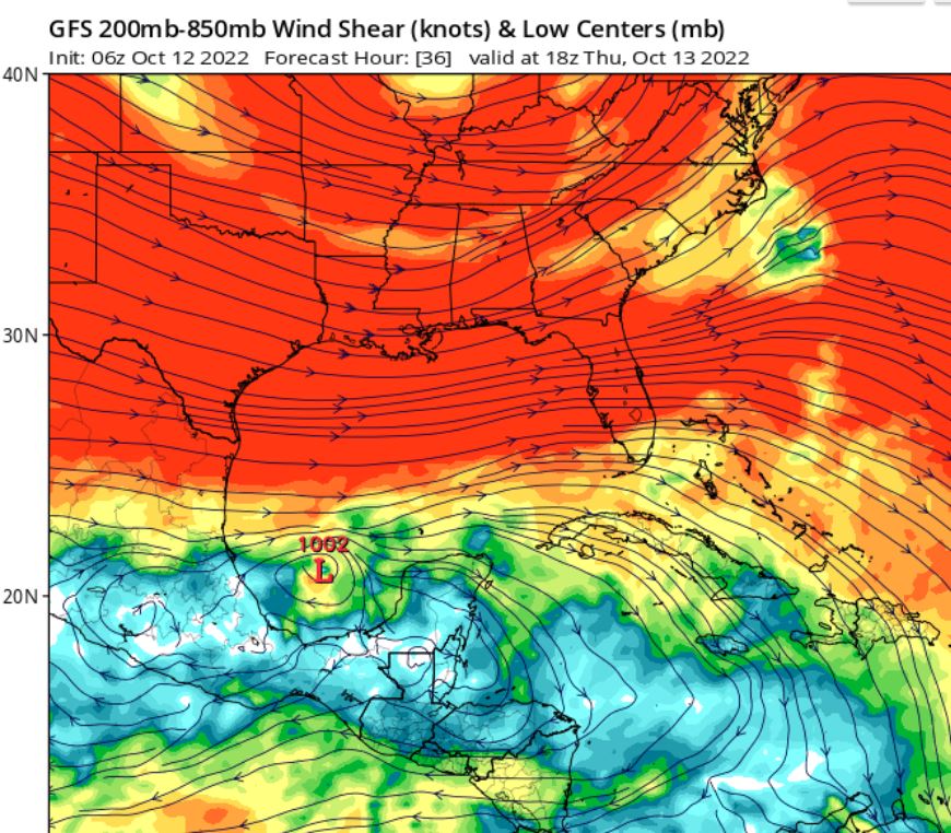
The entire northern Gulf is dominated by very strong westerly wind shear. Those strong west winds aloft are digging southward into the Bay of Campeche. Nothing could survive that shear and make it into the Gulf. Shear will be increasing across the BoC over the next 24-48 hours, causing Karl to weaken.
http://wxman57.com/images/KarlShear.JPG
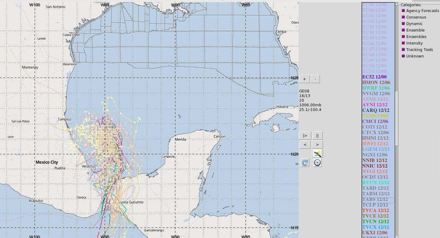
Finally, here's a plot of about 130-140 different models + ensembles. Not one takes Karl north of 24N. They all see the building ride to its north. If you live on the Gulf coast, you'll be fine. This is not a situation similar to Opal in 1995. Even Florida will be fine. No threat there. By the way, Canadian ensembles are yellow, GFS in orange, ECMWF is purple.
http://wxman57.com/images/KarlModels.JPG
The front is not your typical NE-SW oriented cold front, it's more of an east-west oriented front. The primary steering current for Karl will be the ridge (500mb) that is building eastward across Mexico today. The ridge will steer Karl southward into southern Mexico. You can see the ridge building east on the image below:
http://wxman57.com/images/Karl500mb.JPG
The entire northern Gulf is dominated by very strong westerly wind shear. Those strong west winds aloft are digging southward into the Bay of Campeche. Nothing could survive that shear and make it into the Gulf. Shear will be increasing across the BoC over the next 24-48 hours, causing Karl to weaken.
http://wxman57.com/images/KarlShear.JPG
Finally, here's a plot of about 130-140 different models + ensembles. Not one takes Karl north of 24N. They all see the building ride to its north. If you live on the Gulf coast, you'll be fine. This is not a situation similar to Opal in 1995. Even Florida will be fine. No threat there. By the way, Canadian ensembles are yellow, GFS in orange, ECMWF is purple.
http://wxman57.com/images/KarlModels.JPG
3 likes
-
chris_fit
- Category 5
- Posts: 3261
- Age: 43
- Joined: Wed Sep 10, 2003 11:58 pm
- Location: Tampa Bay Area, FL
Re: ATL: KARL - Models
wxman57 wrote:Since there are concerns that Karl may be "picked up by the approaching front", let me explain why that won't happen.
The front is not your typical NE-SW oriented cold front, it's more of an east-west oriented front. The primary steering current for Karl will be the ridge (500mb) that is building eastward across Mexico today. The ridge will steer Karl southward into southern Mexico. You can see the ridge building east on the image below:
http://wxman57.com/images/Karl500mb.JPG
http://wxman57.com/images/Karl500mb.JPG
The entire northern Gulf is dominated by very strong westerly wind shear. Those strong west winds aloft are digging southward into the Bay of Campeche. Nothing could survive that shear and make it into the Gulf. Shear will be increasing across the BoC over the next 24-48 hours, causing Karl to weaken.
http://wxman57.com/images/KarlShear.JPG
http://wxman57.com/images/KarlShear.JPG
Finally, here's a plot of about 130-140 different models + ensembles. Not one takes Karl north of 24N. They all see the building ride to its north. If you live on the Gulf coast, you'll be fine. This is not a situation similar to Opal in 1995. Even Florida will be fine. No threat there. By the way, Canadian ensembles are yellow, GFS in orange, ECMWF is purple.
http://wxman57.com/images/KarlModels.JPG
http://wxman57.com/images/KarlModels.JPG
And this is why I love this place. Thanks for taking the time to educate us 57!
1 likes

Re: ATL: INVEST 93L - Models
chris_fit wrote:boca wrote:Forecast to go into Mexico not the panhandle the cold front is supposed to force it southward.
Can someone explain this one? I always thought fronts/troughs 'picked up' storms not 'pushed' them further south (like a ridge.)
For the most part tropical systems move roughly east to west. When they encounter fronts, those front are usually pushing off the North American continent and they hit the east side of them. If you look at the winds that means they usually are rounding around the western edge of a high pressure system to the east of the front that is itself moving east.
In this case however the center of the high will be be to the northeast of the storm. So as it moves south the storm will get pushed by it, and eventually get pushed west by the winds around the high. Think of a fish storm in the middle of the Atlanic hitting up against the Bermuda high and getting pushed west. But in this case land interaction (and I assume dry air and shear) will kill it.
0 likes
Re: ATL: KARL - Models
Here's today's 12Z UKMET, which is almost spot on vs its current recon based position. This has its current NE drift stop by tomorrow morning followed by a turn to the SSE the subsequent 48 hours:
MET OFFICE TROPICAL CYCLONE GUIDANCE FOR NORTH-EAST PACIFIC AND ATLANTIC
GLOBAL MODEL DATA TIME 1200UTC 12.10.2022
TROPICAL STORM KARL ANALYSED POSITION : 21.6N 95.0W
ATCF IDENTIFIER : AL142022
LEAD CENTRAL MAXIMUM WIND
VERIFYING TIME TIME POSITION PRESSURE (MB) SPEED (KNOTS)
-------------- ---- -------- ------------- -------------
1200UTC 12.10.2022 0 21.6N 95.0W 1008 28
0000UTC 13.10.2022 12 22.0N 94.6W 1007 29
1200UTC 13.10.2022 24 22.1N 94.4W 1007 25
0000UTC 14.10.2022 36 21.4N 94.0W 1006 25
1200UTC 14.10.2022 48 20.6N 93.6W 1007 25
0000UTC 15.10.2022 60 20.2N 93.3W 1006 29
1200UTC 15.10.2022 72 20.0N 93.8W 1008 30
0000UTC 16.10.2022 84 CEASED TRACKING
---------------------------------
*Edit: I'll now add the Oct 13th 0Z UKMET:
TROPICAL STORM KARL ANALYSED POSITION : 22.4N 94.2W
ATCF IDENTIFIER : AL142022
LEAD CENTRAL MAXIMUM WIND
VERIFYING TIME TIME POSITION PRESSURE (MB) SPEED (KNOTS)
-------------- ---- -------- ------------- -------------
0000UTC 13.10.2022 0 22.4N 94.2W 1004 34
1200UTC 13.10.2022 12 22.7N 94.0W 1005 30
0000UTC 14.10.2022 24 21.6N 93.3W 1004 27
1200UTC 14.10.2022 36 21.1N 93.0W 1005 24
0000UTC 15.10.2022 48 20.5N 92.6W 1005 28
1200UTC 15.10.2022 60 20.0N 92.9W 1007 27
0000UTC 16.10.2022 72 19.5N 93.5W 1008 27
1200UTC 16.10.2022 84 CEASED TRACKING
-------------------------
*Edit: Here's the Oct 13th 12Z UKMET for the record:
TROPICAL STORM KARL ANALYSED POSITION : 21.9N 94.2W
ATCF IDENTIFIER : AL142022
LEAD CENTRAL MAXIMUM WIND
VERIFYING TIME TIME POSITION PRESSURE (MB) SPEED (KNOTS)
-------------- ---- -------- ------------- -------------
1200UTC 13.10.2022 0 21.9N 94.2W 1003 29
0000UTC 14.10.2022 12 20.9N 93.3W 1002 31
1200UTC 14.10.2022 24 20.0N 92.8W 1002 31
0000UTC 15.10.2022 36 19.3N 92.8W 1003 28
1200UTC 15.10.2022 48 18.4N 93.9W 1006 33
0000UTC 16.10.2022 60 CEASED TRACKING
0 likes
Personal Forecast Disclaimer:
The posts in this forum are NOT official forecasts and should not be used as such. They are just the opinion of the poster and may or may not be backed by sound meteorological data. They are NOT endorsed by any professional institution or storm2k.org. For official information, please refer to the NHC and NWS products.
The posts in this forum are NOT official forecasts and should not be used as such. They are just the opinion of the poster and may or may not be backed by sound meteorological data. They are NOT endorsed by any professional institution or storm2k.org. For official information, please refer to the NHC and NWS products.
Who is online
Users browsing this forum: No registered users and 44 guests