ATL: INVEST 98L - Models

Moderator: S2k Moderators
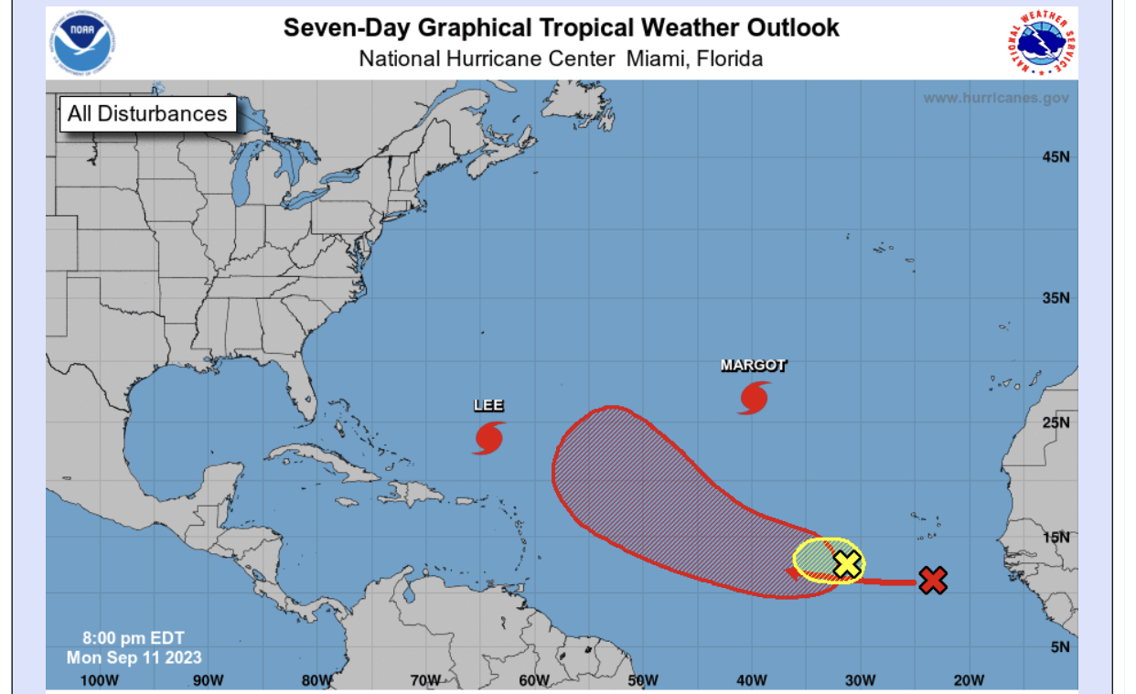
Message
Author
User avatar
Iceresistance
Category 5
Category 5
Posts: 8925
Age: 20
Joined: Sat Oct 10, 2020 9:45 am
Location: Tecumseh, OK/Norman, OK

ATL: INVEST 98L - Models

#1 Postby Iceresistance » Mon Sep 11, 2023 1:03 pm

2 likes   
Bill 2015 & Beta 2020

Winter 2020-2021 :cold:

All observations are in Tecumseh, OK unless otherwise noted.

Winter posts are focused mainly for Oklahoma & Texas.

Take any of my forecasts with a grain of salt, refer to the NWS, SPC, and NHC for official information

Never say Never with weather! Because ANYTHING is possible!

AutoPenalti
Category 5
Category 5
Posts: 3949
Age: 27
Joined: Mon Aug 17, 2015 4:16 pm
Location: Ft. Lauderdale, Florida

Re: ATL: INVEST 98L - Models

#2 Postby AutoPenalti » Mon Sep 11, 2023 1:11 pm

Ensembles for this should be interesting
0 likes   
The posts in this forum are NOT official forecasts and should not be used as such. They are just the opinion of the poster and may or may not be backed by sound meteorological data. They are NOT endorsed by any professional institution or STORM2K. For official information, please refer to products from the NHC and NWS.


Model Runs Cheat Sheet:
GFS (5:30 AM/PM, 11:30 AM/PM)
HWRF, GFDL, UKMET, NAVGEM (6:30-8:00 AM/PM, 12:30-2:00 AM/PM)
ECMWF (1:45 AM/PM)

TCVN
is a weighted averaged

User avatar
ScottNAtlanta
Category 5
Category 5
Posts: 2006
Joined: Sat May 25, 2013 3:11 pm
Location: Atlanta, GA

Re: ATL: INVEST 98L - Models

#3 Postby ScottNAtlanta » Mon Sep 11, 2023 1:14 pm


Just further west
0 likes   
The posts in this forum are NOT official forecast and should not be used as such. They are just the opinion of the poster and may or may not be backed by sound meteorological data. They are NOT endorsed by any professional institution or storm2k.org. For official information, please refer to the NHC and NWS products.

User avatar
SouthFLTropics
Category 5
Category 5
Posts: 4156
Age: 48
Joined: Thu Aug 14, 2003 8:04 am
Location: Port St. Lucie, Florida

Re: ATL: INVEST 98L - Models

#4 Postby SouthFLTropics » Mon Sep 11, 2023 1:20 pm

The GFS absolutely hates the Northeast and Canada this year. Back to back with Lee and now this. That would certainly make a major impact on New England.
1 likes   
Fourth Generation Floridian...With lots of storm knowledge passed down from my elders...

Personal Storm History: David 79, Andrew 92, Erin 95, Floyd 99, Irene 99, Frances 04, Jeanne 04, Wilma 05, Matthew 16, Irma 17

User avatar
Kazmit
Category 5
Category 5
Posts: 1915
Age: 21
Joined: Mon Jul 25, 2016 8:49 am
Location: Williamsburg VA for college, Bermuda otherwise

Re: ATL: INVEST 98L - Models

#5 Postby Kazmit » Mon Sep 11, 2023 1:24 pm


Notice how it doesn't peak until it gets west of Lee's cold wake near the Bahamas.
0 likes   
Igor 2010, Sandy 2012, Fay 2014, Gonzalo 2014, Joaquin 2015, Nicole 2016, Humberto 2019

I am only a tropical weather enthusiast. My predictions are not official and may or may not be backed by sound meteorological data. For official information, please refer to the NHC and NWS products.

Tekken_Guy
Tropical Depression
Tropical Depression
Posts: 97
Joined: Fri Sep 01, 2017 8:08 pm

Re: ATL: INVEST 98L - Models

#6 Postby Tekken_Guy » Mon Sep 11, 2023 2:07 pm

These models also show a 990mb storm off the coast of Portugal later this week that beats 98L to both <1005mb and <1000mb. So unless that other system is just a windstorm, this could be Ophelia.
1 likes   

User avatar
cycloneye
Admin
Admin
Posts: 139327
Age: 67
Joined: Thu Oct 10, 2002 10:54 am
Location: San Juan, Puerto Rico

Re: ATL: INVEST 98L - Models

#7 Postby cycloneye » Mon Sep 11, 2023 8:07 pm

Another major in the pipe for the 2023 season?

Image
4 likes   
Visit the Caribbean-Central America Weather Thread where you can find at first post web cams,radars
and observations from Caribbean basin members Click Here

User avatar
Blown Away
S2K Supporter
S2K Supporter
Posts: 9867
Joined: Wed May 26, 2004 6:17 am

Re: ATL: INVEST 98L - Models

#8 Postby Blown Away » Mon Sep 11, 2023 8:21 pm

Image
Image
Image

NHC cone says forget you GFS, we’re going with King Euro…
1 likes   
Hurricane Eye Experience: David 79, Irene 99, Frances 04, Jeanne 04, Wilma 05... EYE COMING MY WAY IN 2024…
Hurricane Brush Experience: Andrew 92, Erin 95, Floyd 99, Matthew 16, Irma 17, Ian 22, Nicole 22…

User avatar
TheDreamTraveler
Category 2
Category 2
Posts: 633
Joined: Sun Aug 22, 2010 3:10 am
Location: PA

Re: ATL: INVEST 98L - Models

#9 Postby TheDreamTraveler » Tue Sep 12, 2023 1:58 am

I like how the 0Z GFS loops this system around right off the Carolinas while there's yet another hurricane right behind it that would follow along in its weakness lol
0 likes   

mantis83
Tropical Storm
Tropical Storm
Posts: 123
Joined: Fri Dec 05, 2003 4:47 pm

Re: ATL: INVEST 98L - Models

#10 Postby mantis83 » Tue Sep 12, 2023 5:42 am

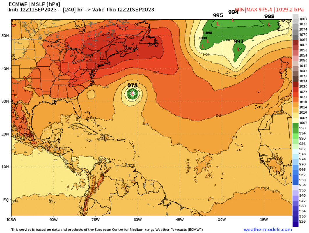
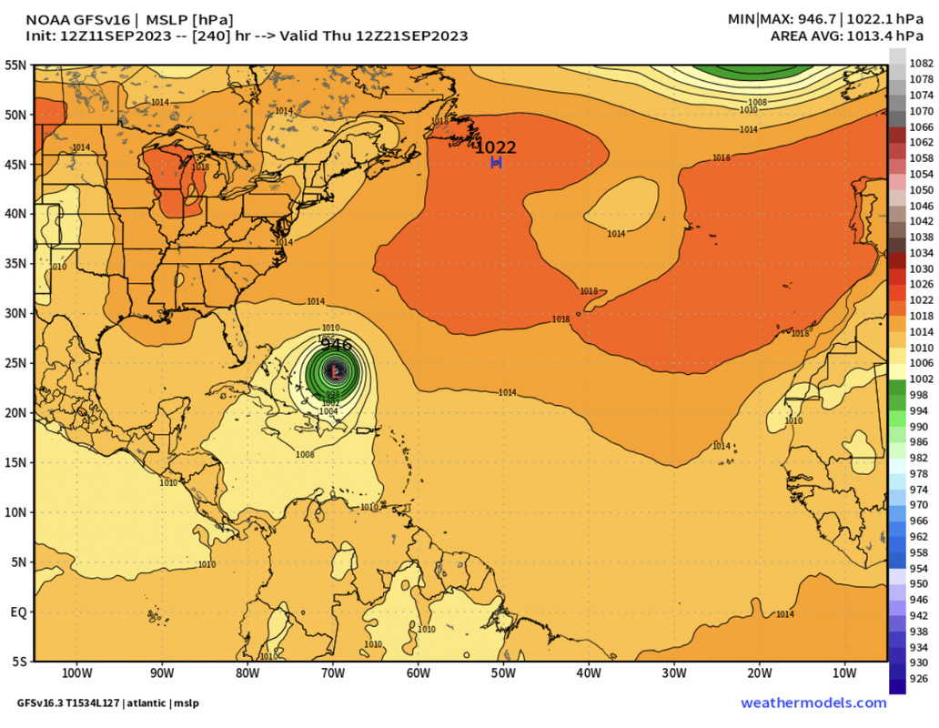
TheDreamTraveler wrote:I like how the 0Z GFS loops this system around right off the Carolinas while there's yet another hurricane right behind it that would follow along in its weakness lol

6z gfs is waaaay further east, similar to the euro, a safe recurve out to sea
0 likes   

User avatar
ThunderForce
Tropical Storm
Tropical Storm
Posts: 158
Age: 25
Joined: Tue Sep 27, 2022 6:20 pm
Location: Florida Panhandle

Re: ATL: INVEST 98L - Models

#11 Postby ThunderForce » Tue Sep 12, 2023 6:25 am

Here's a comparison of both the operational 06z GFS and 06z GEFS ensembles at the 00z Wednesday, September 20th mark. (Forecast hour 186)

06z GFS
Image
06z GEFS
Image
0 likes   
Please refer to the NWS, NHC, SPC or a professional meteorologist for information and decision making during storms.

BobHarlem
Category 5
Category 5
Posts: 1665
Joined: Thu Oct 20, 2005 6:11 pm

Re: ATL: INVEST 98L - Models

#12 Postby BobHarlem » Tue Sep 12, 2023 11:29 pm

0z GFS has this directly on top of Bermuda
Image
0 likes   


Return to “2023”

Who is online

Users browsing this forum: No registered users and 4 guests