ATL: INVEST 95L - Discussion

Moderator: S2k Moderators

Message
Author
User avatar
ouragans
Category 1
Category 1
Posts: 466
Age: 52
Joined: Sun Jun 12, 2011 12:09 pm
Location: Abymes, Guadeloupe F.W.I
Contact:

Re: ATL: INVEST 95L - Discussion- Code Red 70%

#101 Postby ouragans » Sat Jul 22, 2023 1:20 am

Still 50/70. Mention for the LA added

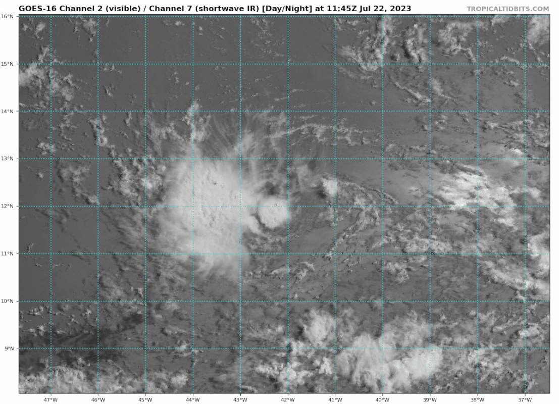
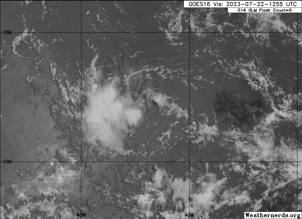
1. Central Tropical Atlantic (AL95):
Shower activity associated with a small area of low pressure located
roughly midway between the Cabo Verde Islands and the Lesser
Antilles is showing signs of organization. Although environmental
conditions are only marginally conducive, slow development is
expected and this system will likely become a tropical depression by
early next week while it moves westward across the tropical
Atlantic. Interests in the Lesser Antilles should monitor the
progress of this system.
* Formation chance through 48 hours...medium...50 percent.
* Formation chance through 7 days...high...70 percent.


Image
1 likes   
Personal forecast disclaimer
This post is a personal point of view, not an information. Please refer to official statements for life-threatening decisions.

David '79, Frederic '79, Hugo '89, Iris, Luis & Marilyn '95, Georges '98, Lenny '99, Dean '07, Irma '17, Maria '17, Fiona '22, Philippe '23, Tammy '23
16°13'33.3,"6N -61°36'39.5"W

User avatar
REDHurricane
Tropical Storm
Tropical Storm
Posts: 207
Age: 26
Joined: Sun Jul 03, 2022 2:36 pm
Location: Northeast Pacific Ocean

Re: ATL: INVEST 95L - Discussion- Code Red 70%

#102 Postby REDHurricane » Sat Jul 22, 2023 1:35 am

chaser1 wrote: I believe that the culprit of greatest influence is a massive easterly surge approaching from the east and northeast.


Yep, looks like it

Image
0 likes   

Sciencerocks
Category 5
Category 5
Posts: 7287
Age: 38
Joined: Thu Jul 06, 2017 1:51 am

Re: ATL: INVEST 95L - Discussion- Code Red 70%

#103 Postby Sciencerocks » Sat Jul 22, 2023 4:01 am

Image
2 likes   

User avatar
cycloneye
Admin
Admin
Posts: 139329
Age: 67
Joined: Thu Oct 10, 2002 10:54 am
Location: San Juan, Puerto Rico

Re: ATL: INVEST 95L - Discussion- Code Red 70%

#104 Postby cycloneye » Sat Jul 22, 2023 6:31 am

8 AM TWO:

Central Tropical Atlantic (AL95):
Shower activity associated with a small area of low pressure located
roughly midway between the Cabo Verde Islands and the Lesser
Antilles continues to show signs of organization. Although
environmental conditions are only marginally conducive, some
additional gradual development is anticipated and this system will
likely become a tropical depression by early next week while it
moves westward across the tropical Atlantic. Interests in the
Lesser Antilles should monitor the progress of this system.
* Formation chance through 48 hours...medium...50 percent.
* Formation chance through 7 days...high...70 percent.
1 likes   
Visit the Caribbean-Central America Weather Thread where you can find at first post web cams,radars
and observations from Caribbean basin members Click Here

User avatar
wxman57
Moderator-Pro Met
Moderator-Pro Met
Posts: 22484
Age: 66
Joined: Sat Jun 21, 2003 8:06 pm
Location: Houston, TX (southwest)

Re: ATL: INVEST 95L - Discussion- Code Red 70%

#105 Postby wxman57 » Sat Jul 22, 2023 7:19 am

Doesn't look impressive at all this morning. Weak swirl east of limited convection. Model support is dwindling. Looking more like it won't make it to TD.
5 likes   

User avatar
cycloneye
Admin
Admin
Posts: 139329
Age: 67
Joined: Thu Oct 10, 2002 10:54 am
Location: San Juan, Puerto Rico

Re: ATL: INVEST 95L - Discussion- Code Red 70%

#106 Postby cycloneye » Sat Jul 22, 2023 7:57 am

Is doing the small dip that the models have. From 12.4N at 06Z to 12.1N at 12z.

AL, 95, 2023072212, , BEST, 0, 121N, 417W, 25, 1012, LO


https://ftp.nhc.noaa.gov/atcf/btk/bal952023.dat
1 likes   
Visit the Caribbean-Central America Weather Thread where you can find at first post web cams,radars
and observations from Caribbean basin members Click Here

underthwx
Category 5
Category 5
Posts: 1929
Joined: Sat Jul 30, 2011 2:14 pm
Location: Brazoria County Texas

Re: ATL: INVEST 95L - Discussion- Code Red 70%

#107 Postby underthwx » Sat Jul 22, 2023 8:07 am

wxman57 wrote:Doesn't look impressive at all this morning. Weak swirl east of limited convection. Model support is dwindling. Looking more like it won't make it to TD.


Sure looks tiny out there over the ocean...is the system being inhibited by dust from the Sahara?
0 likes   

User avatar
REDHurricane
Tropical Storm
Tropical Storm
Posts: 207
Age: 26
Joined: Sun Jul 03, 2022 2:36 pm
Location: Northeast Pacific Ocean

Re: ATL: INVEST 95L - Discussion- Code Red 70%

#108 Postby REDHurricane » Sat Jul 22, 2023 8:17 am

underthwx wrote:
wxman57 wrote:Doesn't look impressive at all this morning. Weak swirl east of limited convection. Model support is dwindling. Looking more like it won't make it to TD.


Sure looks tiny out there over the ocean...is the system being inhibited by dust from the Sahara?


Guessing it's likely some combination of the Saharan air layer and stronger than expected easterly wind shear
1 likes   

User avatar
wxman57
Moderator-Pro Met
Moderator-Pro Met
Posts: 22484
Age: 66
Joined: Sat Jun 21, 2003 8:06 pm
Location: Houston, TX (southwest)

Re: ATL: INVEST 95L - Discussion- Code Red 70%

#109 Postby wxman57 » Sat Jul 22, 2023 8:47 am

underthwx wrote:
wxman57 wrote:Doesn't look impressive at all this morning. Weak swirl east of limited convection. Model support is dwindling. Looking more like it won't make it to TD.


Sure looks tiny out there over the ocean...is the system being inhibited by dust from the Sahara?


The dry air isn't helping. Can't rule out a very small TS but that's looking less likely this morning.
2 likes   

User avatar
abajan
S2K Supporter
S2K Supporter
Posts: 4175
Joined: Sun Sep 07, 2003 5:10 am
Location: Barbados

Re: ATL: INVEST 95L - Discussion- Code Red 70%

#110 Postby abajan » Sat Jul 22, 2023 8:54 am

wxman57 wrote:
underthwx wrote:
wxman57 wrote:Doesn't look impressive at all this morning. Weak swirl east of limited convection. Model support is dwindling. Looking more like it won't make it to TD.


Sure looks tiny out there over the ocean...is the system being inhibited by dust from the Sahara?


The dry air isn't helping. Can't rule out a very small TS but that's looking less likely this morning.


Looks like Mr. Weatherman (Meteorologist Brian Shields) is pretty much on the same wavelength as you. Great minds... 8-)


Link: https://youtu.be/3gh2WTdiN4Q
1 likes   

USTropics
Category 5
Category 5
Posts: 2420
Joined: Sun Aug 12, 2007 3:45 am
Location: Florida State University

Re: ATL: INVEST 95L - Discussion- Code Red 70%

#111 Postby USTropics » Sat Jul 22, 2023 9:11 am

Limited convection is a direct result of the background environment. We can see on the GFS 700-300mb RH analysis the obstacles 95L has to overcome. This causes multiple issues in the convective processes as (1) the system has to expend convective resources to battle against this background environment, (2) it limits convective expansion of the system (via degraded uplift in absent of a moist environment), and (3) it restricts inflow and outflow channels to the north and northwest:
Image

Looking at the GFS sounding for 95L, while there isn't excessive shear, there is a change in steering regime starting at the mid-levels which is likely causing the displacement:
Image

One other thing to note, as far as the SW dip, notice the orientation of the ridging here at the lower-levels (roughly highlighted in blue) and where the strongest steering influences are currently being felt with a weak/disorganized system. Don is making its second traverse over the top of an expanding subtropical high pressure area (track highlighted in pink), and this will again influence the orientation of the ridge:
Image

The models haven't exactly handled the strength of Don particularly well, and you can see even at 24 hours Don has just enough of an influence on the SW periphery of the ridge to force 95L to dip southwest (where a center relocation would also be more expected given convective parameters):
Image

With that said, the environment up until the Caribbean is marginally conducive for development. Once the system enters the eastern Caribbean, and with Don now out of the picture, high pressure begins to dominate the subtropical Atlantic:
Image

This causes increased easterly flow in the Caribbean:
Image

One last side note, there have been mentions on Twitter that this shear is related to El Nino; we would expect westerly wind shear (not easterly) if this was a result of El Nino (which typically occurs when the subtropical jet becomes amplified, which we haven't seen). This is your typical Caribbean/increased trades shear during July/early August.
16 likes   

User avatar
gatorcane
S2K Supporter
S2K Supporter
Posts: 23499
Age: 46
Joined: Sun Mar 13, 2005 3:54 pm
Location: Boca Raton, FL

Re: ATL: INVEST 95L - Discussion- Code Red 70%

#112 Postby gatorcane » Sat Jul 22, 2023 9:22 am

USTropics wrote:Limited convection is a direct result of the background environment. We can see on the GFS 700-300mb RH analysis the obstacles 95L has to overcome. This causes multiple issues in the convective processes as (1) the system has to expend convective resources to battle against this background environment, (2) it limits convective expansion of the system (via degraded uplift in absent of a moist environment), and (3) it restricts inflow and outflow channels to the north and northwest:
https://i.imgur.com/VhKLfez.png

Looking at the GFS sounding for 95L, while there isn't excessive shear, there is a change in steering regime starting at the mid-levels which is likely causing the displacement:
https://i.imgur.com/ZAa65e2.png

One other thing to note, as far as the SW dip, notice the orientation of the ridging here at the lower-levels (roughly highlighted in blue) and where the strongest steering influences are currently being felt with a weak/disorganized system. Don is making its second traverse over the top of an expanding subtropical high pressure area (track highlighted in pink), and this will again influence the orientation of the ridge:
https://i.imgur.com/g1UX0Hs.png

The models haven't exactly handled the strength of Don particularly well, and you can see even at 24 hours Don has just enough of an influence on the SW periphery of the ridge to force 95L to dip southwest (where a center relocation would also be more expected given convective parameters):
https://i.imgur.com/DBqB7py.png

With that said, the environment up until the Caribbean is marginally conducive for development. Once the system enters the eastern Caribbean, and with Don now out of the picture, high pressure begins to dominate the subtropical Atlantic:
https://i.imgur.com/7JueMxz.png

This causes increased easterly flow in the Caribbean:
https://i.imgur.com/mDmfnXe.png

One last side note, there have been mentions on Twitter that this shear is related to El Nino; we would expect westerly wind shear (not easterly) if this was a result of El Nino (which typically occurs when the subtropical jet becomes amplified, which we haven't seen). This is your typical Caribbean/increased trades shear during July/early August.


Thanks I really enjoy your posts and detailed analysis.

95l is really struggling this morning as posters have noted. It is not just dry air but some shear as well:

Image
0 likes   

User avatar
Teban54
Category 5
Category 5
Posts: 1974
Joined: Sat May 19, 2018 1:19 pm

Re: ATL: INVEST 95L - Discussion- Code Red 70%

#113 Postby Teban54 » Sat Jul 22, 2023 9:31 am

gatorcane wrote:
USTropics wrote:Limited convection is a direct result of the background environment. We can see on the GFS 700-300mb RH analysis the obstacles 95L has to overcome. This causes multiple issues in the convective processes as (1) the system has to expend convective resources to battle against this background environment, (2) it limits convective expansion of the system (via degraded uplift in absent of a moist environment), and (3) it restricts inflow and outflow channels to the north and northwest:
https://i.imgur.com/VhKLfez.png

Looking at the GFS sounding for 95L, while there isn't excessive shear, there is a change in steering regime starting at the mid-levels which is likely causing the displacement:
https://i.imgur.com/ZAa65e2.png

One other thing to note, as far as the SW dip, notice the orientation of the ridging here at the lower-levels (roughly highlighted in blue) and where the strongest steering influences are currently being felt with a weak/disorganized system. Don is making its second traverse over the top of an expanding subtropical high pressure area (track highlighted in pink), and this will again influence the orientation of the ridge:
https://i.imgur.com/g1UX0Hs.png

The models haven't exactly handled the strength of Don particularly well, and you can see even at 24 hours Don has just enough of an influence on the SW periphery of the ridge to force 95L to dip southwest (where a center relocation would also be more expected given convective parameters):
https://i.imgur.com/DBqB7py.png

With that said, the environment up until the Caribbean is marginally conducive for development. Once the system enters the eastern Caribbean, and with Don now out of the picture, high pressure begins to dominate the subtropical Atlantic:
https://i.imgur.com/7JueMxz.png

This causes increased easterly flow in the Caribbean:
https://i.imgur.com/mDmfnXe.png

One last side note, there have been mentions on Twitter that this shear is related to El Nino; we would expect westerly wind shear (not easterly) if this was a result of El Nino (which typically occurs when the subtropical jet becomes amplified, which we haven't seen). This is your typical Caribbean/increased trades shear during July/early August.


Thanks I really enjoy your posts and detailed analysis.

95l is really struggling this morning as posters have noted. It is not just dry air but some shear as well:

https://i.postimg.cc/dVXX1b5V/goes16-vis-swir-95-L-202307221145.gif

Looks like the LLC is being pulled towards the convection.
0 likes   

Sciencerocks
Category 5
Category 5
Posts: 7287
Age: 38
Joined: Thu Jul 06, 2017 1:51 am

Re: ATL: INVEST 95L - Discussion- Code Red 70%

#114 Postby Sciencerocks » Sat Jul 22, 2023 11:28 am

Image
1 likes   

underthwx
Category 5
Category 5
Posts: 1929
Joined: Sat Jul 30, 2011 2:14 pm
Location: Brazoria County Texas

Re: ATL: INVEST 95L - Discussion- Code Red 70%

#115 Postby underthwx » Sat Jul 22, 2023 11:41 am

abajan wrote:
wxman57 wrote:
underthwx wrote:
Sure looks tiny out there over the ocean...is the system being inhibited by dust from the Sahara?


The dry air isn't helping. Can't rule out a very small TS but that's looking less likely this morning.


Looks like Mr. Weatherman (Meteorologist Brian Shields) is pretty much on the same wavelength as you. Great minds... 8-)

https://youtu.be/3gh2WTdiN4Q


I haven't read about 95L, my apologies if my question had an obvious answer already posted here Abajan
0 likes   

User avatar
abajan
S2K Supporter
S2K Supporter
Posts: 4175
Joined: Sun Sep 07, 2003 5:10 am
Location: Barbados

Re: ATL: INVEST 95L - Discussion- Code Red 70%

#116 Postby abajan » Sat Jul 22, 2023 12:12 pm

underthwx wrote:
abajan wrote:
wxman57 wrote:
The dry air isn't helping. Can't rule out a very small TS but that's looking less likely this morning.


Looks like Mr. Weatherman (Meteorologist Brian Shields) is pretty much on the same wavelength as you. Great minds... 8-)

https://youtu.be/3gh2WTdiN4Q


I haven't read about 95L, my apologies if my question had an obvious answer already posted here Abajan

No need to apologize, as my comment wasn't really referring to what you posted but to wxman57's (not that I had intentionally ignored what you stated).
1 likes   

User avatar
Teban54
Category 5
Category 5
Posts: 1974
Joined: Sat May 19, 2018 1:19 pm

Re: ATL: INVEST 95L - Discussion- Code Red 70%

#117 Postby Teban54 » Sat Jul 22, 2023 12:15 pm

0 likes   

User avatar
Blown Away
S2K Supporter
S2K Supporter
Posts: 9867
Joined: Wed May 26, 2004 6:17 am

Re: ATL: INVEST 95L - Discussion- Code Red 70%

#118 Postby Blown Away » Sat Jul 22, 2023 12:24 pm

If model support continues to drop, thinking NHC going to lower odds soon.
1 likes   
Hurricane Eye Experience: David 79, Irene 99, Frances 04, Jeanne 04, Wilma 05... EYE COMING MY WAY IN 2024…
Hurricane Brush Experience: Andrew 92, Erin 95, Floyd 99, Matthew 16, Irma 17, Ian 22, Nicole 22…

User avatar
abajan
S2K Supporter
S2K Supporter
Posts: 4175
Joined: Sun Sep 07, 2003 5:10 am
Location: Barbados

Re: ATL: INVEST 95L - Discussion- Code Red 70%

#119 Postby abajan » Sat Jul 22, 2023 12:25 pm

0 likes   

User avatar
cycloneye
Admin
Admin
Posts: 139329
Age: 67
Joined: Thu Oct 10, 2002 10:54 am
Location: San Juan, Puerto Rico

Re: ATL: INVEST 95L - Discussion- Code Red 70%

#120 Postby cycloneye » Sat Jul 22, 2023 12:27 pm

Blown Away wrote:If model support continues to drop, thinking NHC going to lower odds soon.


Bingo.

Central Tropical Atlantic (AL95):
Shower activity associated with a small area of low pressure located
roughly midway between the Cabo Verde Islands and the Lesser
Antilles has become a little less organized since yesterday.
Environmental conditions are forecast to remain marginally conducive
for some gradual development, and this system could become a
tropical depression early next week while it moves westward across
the tropical Atlantic. Interests in the Lesser Antilles should
monitor the progress of this system.
* Formation chance through 48 hours...medium...40 percent.
* Formation chance through 7 days...medium...60 percent.
2 likes   
Visit the Caribbean-Central America Weather Thread where you can find at first post web cams,radars
and observations from Caribbean basin members Click Here


Return to “2023”

Who is online

Users browsing this forum: No registered users and 16 guests