https://twitter.com/doomhaMwx/status/1696557650354245632
WPAC: SAOLA - Post-Tropical
Moderator: S2k Moderators
-
Sciencerocks
- Category 5

- Posts: 10181
- Age: 40
- Joined: Thu Jul 06, 2017 1:51 am
Re: WPAC: SAOLA - Typhoon
0 likes
-
cycloneye

- Admin

- Posts: 149275
- Age: 69
- Joined: Thu Oct 10, 2002 10:54 am
- Location: San Juan, Puerto Rico
Re: WPAC: SAOLA - Typhoon
Not weakening for now.
09W SAOLA 230829 1800 19.9N 121.9E WPAC 135 922
0 likes
Visit the Caribbean-Central America Weather Thread where you can find at first post web cams,radars
and observations from Caribbean basin members Click Here
and observations from Caribbean basin members Click Here
-
cycloneye
- Admin
- Posts: 149275
- Age: 69
- Joined: Thu Oct 10, 2002 10:54 am
- Location: San Juan, Puerto Rico
Re: WPAC: SAOLA - Typhoon
0 likes
Visit the Caribbean-Central America Weather Thread where you can find at first post web cams,radars
and observations from Caribbean basin members Click Here
and observations from Caribbean basin members Click Here


-
mrbagyo

- Category 5
- Posts: 3963
- Age: 33
- Joined: Thu Apr 12, 2012 9:18 am
- Location: 14.13N 120.98E
- Contact:
Re: WPAC: SAOLA - Typhoon
CMA now has Saola at 62 mps (223.2 kph) intensity / 915 hPa
0 likes
The posts in this forum are NOT official forecast and should not be used as such. They are just the opinion of the poster and may or may not be backed by sound meteorological data. They are NOT endorsed by any professional institution or storm2k.org. For official information, please refer to RSMC, NHC and NWS products.
-
doomhaMwx

- Category 5
- Posts: 2487
- Age: 27
- Joined: Tue Apr 18, 2017 4:01 am
- Location: Baguio/Benguet, Philippines
- Contact:
Re: WPAC: SAOLA - Typhoon
55-60 dBZ reflectivity values and at quite a distance too (since this is from Taiwan radar) just really show how intense Saola's eyewall is.

0 likes
-
MarioProtVI
- Category 5
- Posts: 1034
- Age: 24
- Joined: Sun Sep 29, 2019 7:33 pm
- Location: New Jersey
-
cycloneye
- Admin
- Posts: 149275
- Age: 69
- Joined: Thu Oct 10, 2002 10:54 am
- Location: San Juan, Puerto Rico
Re: WPAC: SAOLA - Typhoon
09W SAOLA 230830 0000 20.1N 121.1E WPAC 135 922
0 likes
Visit the Caribbean-Central America Weather Thread where you can find at first post web cams,radars
and observations from Caribbean basin members Click Here
and observations from Caribbean basin members Click Here

Re: WPAC: SAOLA - Typhoon
cycloneye wrote:09W SAOLA 230830 0000 20.1N 121.1E WPAC 135 922
sus
0 likes
-
doomhaMwx
- Category 5
- Posts: 2487
- Age: 27
- Joined: Tue Apr 18, 2017 4:01 am
- Location: Baguio/Benguet, Philippines
- Contact:
Re: WPAC: SAOLA - Typhoon
09W SAOLA 230830 0600 20.4N 120.3E WPAC 135 922
T2309(Saola)
Issued at 2023/08/30 07:05 UTC
Analysis at 08/30 06 UTC
Grade TY
Scale -
Intensity Violent
Center position N20°25′ (20.4°)
E120°20′ (120.3°)
Direction and speed of movement WNW 15 km/h (7 kt)
Central pressure 920 hPa
Maximum sustained wind speed near center 55 m/s (105 kt)
Maximum wind gust speed 75 m/s (150 kt)
Radius of 50-kt wind area 95 km (50 NM)
Radius of 30-kt wind area NW280 km (150 NM)
SE220 km (120 NM)
ZCZC
WTPQ20 BABJ 300600
SUBJECTIVE FORECAST
SuperTY SAOLA 2309 (2309) INITIAL TIME 300600 UTC
00HR 20.4N 120.4E 915HPA 62M/S
30KTS WINDS 250KM NORTHEAST
250KM SOUTHEAST
220KM SOUTHWEST
220KM NORTHWEST
50KTS WINDS 130KM NORTHEAST
130KM SOUTHEAST
130KM SOUTHWEST
130KM NORTHWEST
64KTS WINDS 70KM NORTHEAST
70KM SOUTHEAST
70KM SOUTHWEST
70KM NORTHWEST
MOVE WNW 10KM/H=
NNNN
0 likes

Re: WPAC: SAOLA - Typhoon
00Z

0 likes
ヤンデレ女が寝取られるているのを見たい!!!
ECMWF ensemble NWPAC plots: https://ecmwfensnwpac.imgbb.com/
Multimodel NWPAC plots: https://multimodelnwpac.imgbb.com/
GFS Ensemble NWPAC plots (16 & 35 day forecast): https://gefsnwpac.imgbb.com/
Plots updated automatically
ECMWF ensemble NWPAC plots: https://ecmwfensnwpac.imgbb.com/
Multimodel NWPAC plots: https://multimodelnwpac.imgbb.com/
GFS Ensemble NWPAC plots (16 & 35 day forecast): https://gefsnwpac.imgbb.com/
Plots updated automatically
-
doomhaMwx
- Category 5
- Posts: 2487
- Age: 27
- Joined: Tue Apr 18, 2017 4:01 am
- Location: Baguio/Benguet, Philippines
- Contact:
Re: WPAC: SAOLA - Typhoon
Aqua MODIS pass at 05:45Z today.
Band 31 eye temp: 19.72°C
Band 27 (WV) eye temp: -15.97°C
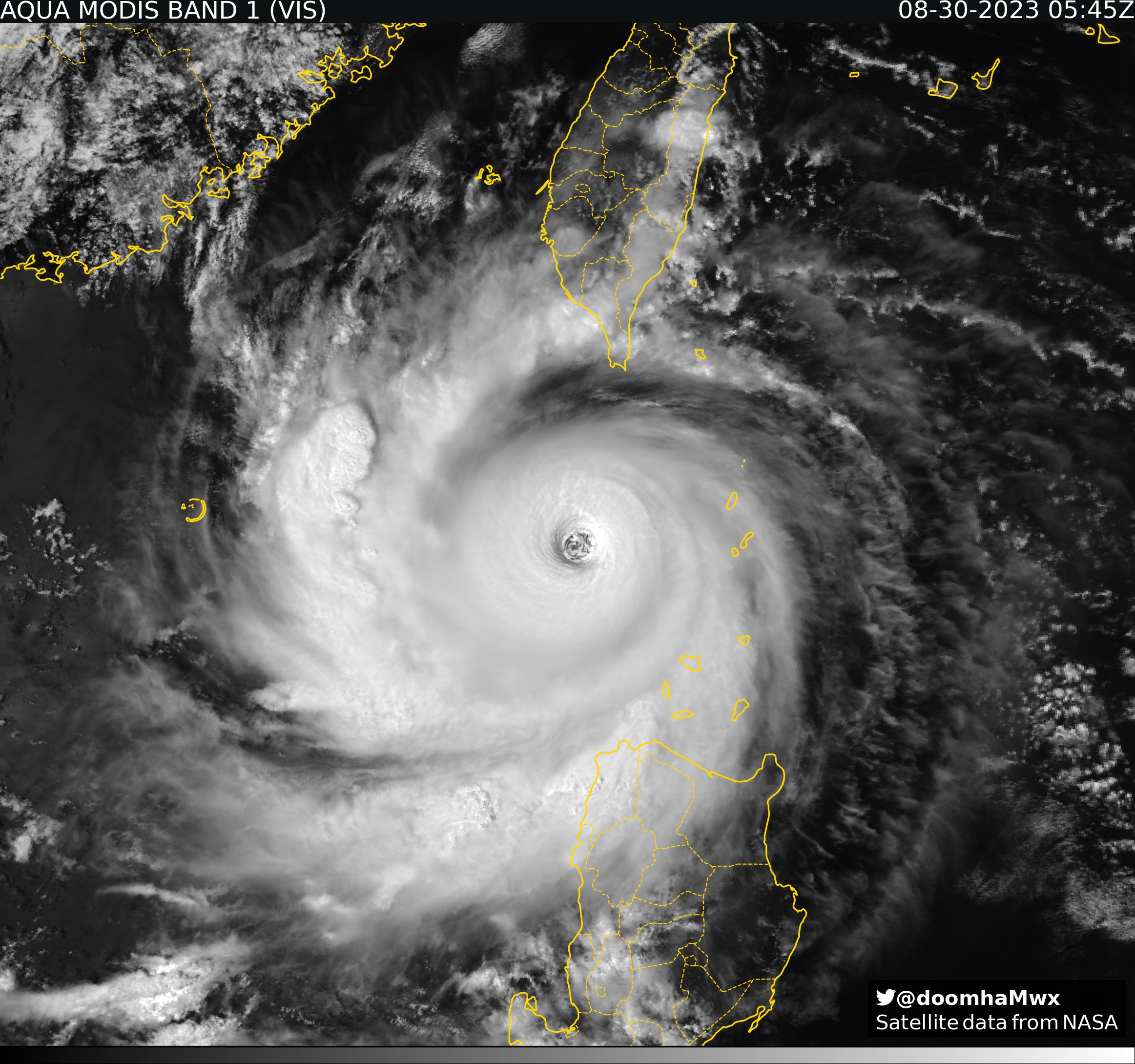
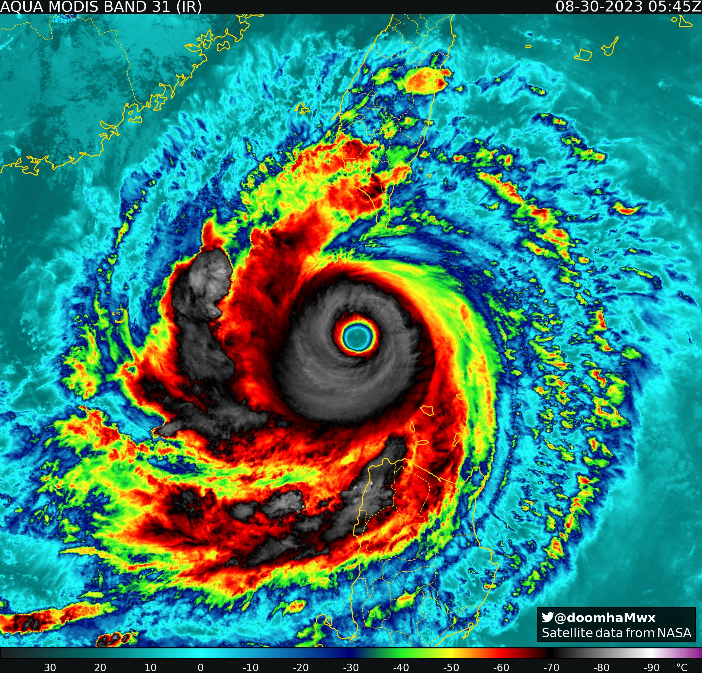
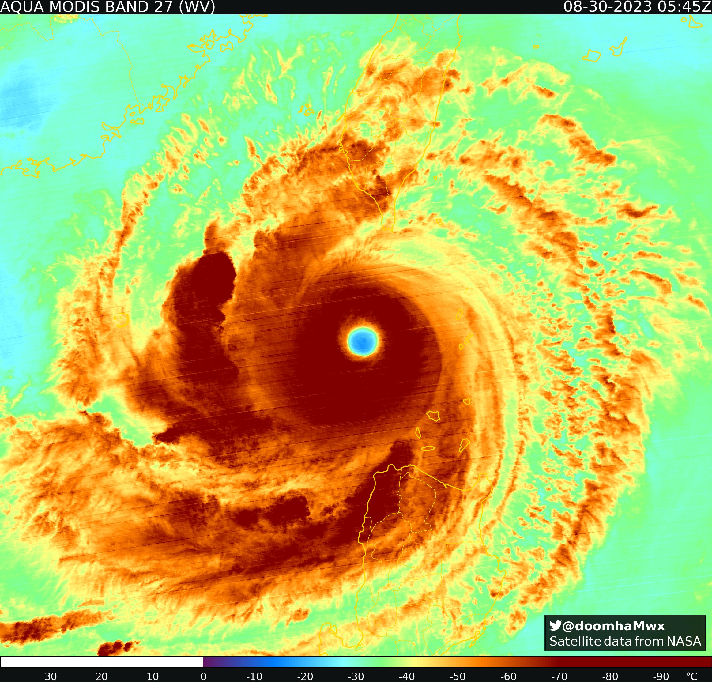
Band 31 eye temp: 19.72°C
Band 27 (WV) eye temp: -15.97°C
2 likes
Re: WPAC: SAOLA - Typhoon
DMINT reporting 140kts

While DPRINT 135kts

While DPRINT 135kts
0 likes
ヤンデレ女が寝取られるているのを見たい!!!
ECMWF ensemble NWPAC plots: https://ecmwfensnwpac.imgbb.com/
Multimodel NWPAC plots: https://multimodelnwpac.imgbb.com/
GFS Ensemble NWPAC plots (16 & 35 day forecast): https://gefsnwpac.imgbb.com/
Plots updated automatically
ECMWF ensemble NWPAC plots: https://ecmwfensnwpac.imgbb.com/
Multimodel NWPAC plots: https://multimodelnwpac.imgbb.com/
GFS Ensemble NWPAC plots (16 & 35 day forecast): https://gefsnwpac.imgbb.com/
Plots updated automatically
-
doomhaMwx
- Category 5
- Posts: 2487
- Age: 27
- Joined: Tue Apr 18, 2017 4:01 am
- Location: Baguio/Benguet, Philippines
- Contact:
Re: WPAC: SAOLA - Typhoon
Although satellite presentation remains impressive, Saola has likely peaked as the latest SSMIS pass already shows a degradation of the internal structure with tell-tale signs of an impending EWRC.


0 likes
-
Kingarabian

- S2K Supporter

- Posts: 16348
- Joined: Sat Aug 08, 2009 3:06 am
- Location: Honolulu, Hawaii
-
cycloneye
- Admin
- Posts: 149275
- Age: 69
- Joined: Thu Oct 10, 2002 10:54 am
- Location: San Juan, Puerto Rico
Re: WPAC: SAOLA - Typhoon
09W SAOLA 230830 1200 20.7N 119.7E WPAC 130 926
0 likes
Visit the Caribbean-Central America Weather Thread where you can find at first post web cams,radars
and observations from Caribbean basin members Click Here
and observations from Caribbean basin members Click Here
-
xtyphooncyclonex

- Category 5
- Posts: 3891
- Age: 24
- Joined: Sat Dec 08, 2012 9:07 am
- Location: Cebu City
- Contact:
Re: WPAC: SAOLA - Typhoon
Quite a powerful looking 130-knot category 4 typhoon for sure. 

CMG definitely makes the downgrade more sensible.

CMG definitely makes the downgrade more sensible.
Last edited by xtyphooncyclonex on Wed Aug 30, 2023 8:19 am, edited 3 times in total.
0 likes
REMINDER: My opinions that I, or any other NON Pro-Met in this forum, are unofficial. Please do not take my opinions as an official forecast and warning. I am NOT a meteorologist. Following my forecasts blindly may lead to false alarm, danger and risk if official forecasts from agencies are ignored.
-
Kingarabian
- S2K Supporter
- Posts: 16348
- Joined: Sat Aug 08, 2009 3:06 am
- Location: Honolulu, Hawaii
Re: WPAC: SAOLA - Typhoon
Basically reached 7.0 yesterday and stuck there for a couple of hours.
0 likes
RIP Kobe Bryant
-
xtyphooncyclonex
- Category 5
- Posts: 3891
- Age: 24
- Joined: Sat Dec 08, 2012 9:07 am
- Location: Cebu City
- Contact:
Re: WPAC: SAOLA - Typhoon
Kingarabian wrote:Basically reached 7.0 yesterday and stuck there for a couple of hours.
Quite a number of agencies stuck with T7.0, including the JTWC themselves. Yet there was no upgrade.
TPPN11 PGTW 301203
A. SUPER TYPHOON 09W (SAOLA)
B. 30/1130Z
C. 20.66N
D. 119.75E
E. ONE/HMWRI9
F. T7.0/7.0/S0.0/24HRS STT: S0.0/03HRS
G. IR/EIR
H. REMARKS: 01A/PBO EYE/ANMTN. WMG EYE SURROUNDED BY W YIELDS AN
E# OF 6.0. ADDED 1.0 EYE ADJUSTMENT FOR CMG, TO YIELD A DT OF 7.0.
MET YIELDS 7.5 AND PT YIELDS 7.0. DBO DT.
I. ADDITIONAL POSITIONS:
30/0716Z 20.45N 120.08E SSMS
GOYETTE
0 likes
REMINDER: My opinions that I, or any other NON Pro-Met in this forum, are unofficial. Please do not take my opinions as an official forecast and warning. I am NOT a meteorologist. Following my forecasts blindly may lead to false alarm, danger and risk if official forecasts from agencies are ignored.
Re: WPAC: SAOLA - Typhoon
SMAP pass from 0948Z 126kts
WP, 09, 202308300948, 30, SMAP, IR, , 2070N, 11970E, , 1, 118, 1, , , , 34, NEQ, 0, 0, 79, 55, , , , , 1, 0, , W, NASA, RSS, , , , , , , , , , , , , , , , , , , , , , , , , , , , 1, max. wind is 10 minute sustained
WP, 09, 202308300948, 30, SMAP, IR, , 2070N, 11970E, , 1, 118, 1, , , , 50, NEQ, 0, 58, 45, 39, , , , , 1, 0, , W, NASA, RSS, , , , , , , , , , , , , , , , , , , , , , , , , , , , 1, max. wind is 10 minute sustained
WP, 09, 202308300948, 30, SMAP, IR, , 2070N, 11970E, , 1, 118, 1, , , , 64, NEQ, 43, 47, 31, 27, , , , , 1, 0, , W, NASA, RSS, , , , , , , , , , , , , , , , , , , , , , , , , , , , 1, max. wind is 10 minute sustained
0 likes
ヤンデレ女が寝取られるているのを見たい!!!
ECMWF ensemble NWPAC plots: https://ecmwfensnwpac.imgbb.com/
Multimodel NWPAC plots: https://multimodelnwpac.imgbb.com/
GFS Ensemble NWPAC plots (16 & 35 day forecast): https://gefsnwpac.imgbb.com/
Plots updated automatically
ECMWF ensemble NWPAC plots: https://ecmwfensnwpac.imgbb.com/
Multimodel NWPAC plots: https://multimodelnwpac.imgbb.com/
GFS Ensemble NWPAC plots (16 & 35 day forecast): https://gefsnwpac.imgbb.com/
Plots updated automatically
Who is online
Users browsing this forum: No registered users and 149 guests