ATL: LEE - Post-Tropical - Discussion
Moderator: S2k Moderators
-
SouthDadeFish

- Professional-Met

- Posts: 2836
- Joined: Thu Sep 23, 2010 2:54 pm
- Location: Miami, FL
- Contact:
Re: ATL: INVEST 95L - Discussion
This system has a very high ceiling. If the stall north of the Antilles verifies, we could be looking at a top-10 ACE Atlantic TC. Hoping this stays north of the islands, but it's uncomfortably close at the moment.
8 likes
-
cycloneye

- Admin

- Posts: 149721
- Age: 69
- Joined: Thu Oct 10, 2002 10:54 am
- Location: San Juan, Puerto Rico
Re: ATL: INVEST 95L - Discussion
1 likes
Visit the Caribbean-Central America Weather Thread where you can find at first post web cams,radars
and observations from Caribbean basin members Click Here
and observations from Caribbean basin members Click Here
-
weeniepatrol

- Category 5

- Posts: 1345
- Joined: Sat Aug 22, 2020 5:30 pm
- Location: WA State
Re: ATL: INVEST 95L - Discussion
Don't see this specific messaging on a TWO too often:
Additional strengthening is likely late this week while the system
moves westward to west-northwestward at 15 to 20 mph over the
central and western portions of the tropical Atlantic.
moves westward to west-northwestward at 15 to 20 mph over the
central and western portions of the tropical Atlantic.
5 likes

Re: ATL: INVEST 95L - Discussion
cycloneye wrote:Blown Away wrote:cycloneye wrote:Central Tropical Atlantic (AL95):
A tropical wave located several hundred miles southwest of the Cabo
Verde Islands is producing a large area of shower and thunderstorm
activity. This system has become better organized since yesterday,
and environmental conditions appear conducive for further
development this week. A tropical depression is likely to form
around midweek while the system moves westward to west-northwestward
at 15 to 20 mph over the central and western portions of the
tropical Atlantic.
* Formation chance through 48 hours...medium...40 percent.
* Formation chance through 7 days...high...80 percent.
Seems the NHC bent their cone back more W at 8am compared to NW turn at 2am??
Yes. More closer to PR.
https://i.imgur.com/I3HZA6Q.png
Yes, and closer to st Maarten too, Luis.
We are going to have a close call on this one.
3 likes
Too many hurricanes to remember
-
cycloneye
- Admin
- Posts: 149721
- Age: 69
- Joined: Thu Oct 10, 2002 10:54 am
- Location: San Juan, Puerto Rico
Re: ATL: INVEST 95L - Discussion
msbee wrote:cycloneye wrote:Blown Away wrote:
Seems the NHC bent their cone back more W at 8am compared to NW turn at 2am??
Yes. More closer to PR.
https://i.imgur.com/I3HZA6Q.png
Yes, and closer to st Maarten too, Luis.
We are going to have a close call on this one.
You are right Barbara. We will be going thru every update to see how are things going and if we in the NE Caribbean have to prepare.
5 likes
Visit the Caribbean-Central America Weather Thread where you can find at first post web cams,radars
and observations from Caribbean basin members Click Here
and observations from Caribbean basin members Click Here

-
InfernoFlameCat

- Category 5
- Posts: 2127
- Age: 23
- Joined: Mon Dec 14, 2020 10:52 am
- Location: Buford, GA
Re: ATL: INVEST 95L - Discussion
This is all very interesting. Let’s hope Lee is able to recurve and be similar to Sam in nature.
0 likes
I am by no means a professional. DO NOT look at my forecasts for official information or make decisions based on what I post.
Goal: to become a registered expert over tropical and subtropical cyclones.
Goal: to become a registered expert over tropical and subtropical cyclones.
-
Hurrilurker

- Category 2

- Posts: 738
- Joined: Mon Jun 09, 2003 3:32 pm
- Location: San Francisco, CA
Re: ATL: INVEST 95L - Discussion
Just looking at the image posted above showing the trough disappearing...at the same time it doesn't look like a ridge is really building into the area either. The ridge to the south would probably keep it out of the Caribbean Sea (ie. south of Cuba) without anything pushing on it from the north, but does it just continue cruising northwest-ish? Bahamas and US EC beware.
0 likes
-
cycloneye
- Admin
- Posts: 149721
- Age: 69
- Joined: Thu Oct 10, 2002 10:54 am
- Location: San Juan, Puerto Rico
Re: ATL: INVEST 95L - Discussion
8 PM.
Central Tropical Atlantic (AL95):
Showers and thunderstorms are showing signs of organization in
association with a tropical wave located several hundred miles
southwest of the Cabo Verde Islands. Environmental conditions are
forecast to be conducive for further development, and this system is
expected to become a tropical depression in two or three days.
Additional strengthening is likely late this week while the system
moves westward to west-northwestward at 15 to 20 mph over the
central and western portions of the tropical Atlantic.
* Formation chance through 48 hours...medium...60 percent.
* Formation chance through 7 days...high...90 percent.
1 likes
Visit the Caribbean-Central America Weather Thread where you can find at first post web cams,radars
and observations from Caribbean basin members Click Here
and observations from Caribbean basin members Click Here
-
jlauderdal
- S2K Supporter

- Posts: 7240
- Joined: Wed May 19, 2004 5:46 am
- Location: NE Fort Lauderdale
- Contact:
Re: RE: Re: ATL: INVEST 95L - Discussion
We need to keep this thing north of PR. Big potential with this system.cycloneye wrote:8 PM.Central Tropical Atlantic (AL95):
Showers and thunderstorms are showing signs of organization in
association with a tropical wave located several hundred miles
southwest of the Cabo Verde Islands. Environmental conditions are
forecast to be conducive for further development, and this system is
expected to become a tropical depression in two or three days.
Additional strengthening is likely late this week while the system
moves westward to west-northwestward at 15 to 20 mph over the
central and western portions of the tropical Atlantic.
* Formation chance through 48 hours...medium...60 percent.
* Formation chance through 7 days...high...90 percent.
4 likes
Re: ATL: INVEST 95L - Discussion

Low-mid level looks moist. It won't take too long to see convection burst around the center.
0 likes
-
WalterWhite

- Category 1

- Posts: 342
- Joined: Fri Mar 17, 2023 5:53 pm
Re: ATL: INVEST 95L - Discussion
zzzh wrote:https://i.imgur.com/QoCCtCd.gif
Low-mid level looks moist. It won't take too long to see convection burst around the center.
Is there an ASCAT map?
0 likes
ATL: INVEST 95L - Models
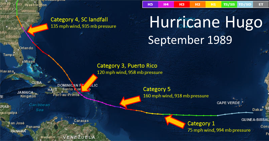
Unfortunately, in my opinion, a 1989 Hurricane Hugo 500mb upper-level pattern can't be ruled out at this juncture. Just 24 to 36 hours ago, I really didn't think such a pattern would ever materialize. But now, I'm not quite so sure. The latest Operational GFS and Euro runs are kind of trending in that direction but in different manners. Nonetheless, most of us have been doing this long enough to know to never take mid to long-range upper patterns verbatim, and calling Fish Storm or CONUS strike based upon these models is premature. With that being said, I have the Hugo upper-level pattern memorized and will be very closely observing how the models resolve the pattern over the forthcoming days.
The U.S. 500mb Geopotential Height Composite Mean between 8/15/1989 and 8/19/1989...
https://psl.noaa.gov/tmp/composites/comphour.cEycrb_WAj.gif
12Z Euro run at 240hrs..
https://www.tropicaltidbits.com/analysis/models/?model=ecmwf®ion=us&pkg=z500_mslp&runtime=2023090312&fh=12
For those of you not familiar with Hurricane Hugo, here's a link for reference...
https://www.weather.gov/ilm/hurricanehugo
7 likes

Re: ATL: INVEST 95L - Discussion
I’m sure some of you have probably been looking at analogs. I really like Bertha 96’ for its origin location along with current projected track of 95L. The intensity will likely be dramatically different down the road which could change things up but the track almost mirrors the model runs out pretty far… especially considering we are starting to see signs that OTS is definitely not a guarantee and the potential west shifts will make it an even better match barring a hard west turn
If that were to verify it’d be a Carolinas issue
If that were to verify it’d be a Carolinas issue
1 likes
-
IsabelaWeather
- Category 1
- Posts: 316
- Age: 36
- Joined: Tue Jul 07, 2020 7:29 am
- Location: Isabela, Puerto Rico
Re: ATL: INVEST 95L - Discussion
zzzh wrote:https://i.imgur.com/QoCCtCd.gif
Low-mid level looks moist. It won't take too long to see convection burst around the center.
DMAX ought to be interesting.
1 likes
-
SFLcane

- S2K Supporter
- Posts: 10281
- Age: 48
- Joined: Sat Jun 05, 2010 1:44 pm
- Location: Lake Worth Florida
Re: ATL: INVEST 95L - Models
Some of us on social media are 0-1 with the predictions this season mention no names lol. Let’s see how this plays out
0 likes
-
dukeblue219
- S2K Supporter
- Posts: 556
- Joined: Fri Sep 30, 2016 3:52 pm
Re: ATL: INVEST 95L - Models
869MB wrote:Unfortunately, in my opinion, a 1989 Hurricane Hugo 500mb upper-level pattern can't be ruled out at this juncture.
I was 3 when Hugo hit SC, and to some degree the damage I saw (and admittedly the excitement as a 3 year old) spurned a lot of my interest in tropical weather to this day. I, too, will be watching the upper levels closely for that rare setup that drives a storm directly into the east coast. Fortunately we are far out and that kind of setup takes everything lined up just right...
Hugo is also infamous as the storm that tried to take down a P-3 with Jeff Masters: https://www.wunderground.com/hurricane/ ... ugo-part-1
1 likes
-
cycloneye
- Admin
- Posts: 149721
- Age: 69
- Joined: Thu Oct 10, 2002 10:54 am
- Location: San Juan, Puerto Rico
Re: ATL: INVEST 95L - Models
869MB wrote:Unfortunately, in my opinion, a 1989 Hurricane Hugo 500mb upper-level pattern can't be ruled out at this juncture. Just 24 to 36 hours ago, I really didn't think such a pattern would ever materialize. But now, I'm not quite so sure. The latest Operational GFS and Euro runs are kind of trending in that direction but in different manners. Nonetheless, most of us have been doing this long enough to know to never take mid to long-range upper patterns verbatim, and calling Fish Storm or CONUS strike based upon these models is premature. With that being said, I have the Hugo upper-level pattern memorized and will be very closely observing how the models resolve the pattern over the forthcoming days.
The U.S. 500mb Geopotential Height Composite Mean between 8/15/1989 and 8/19/1989...
https://psl.noaa.gov/tmp/composites/comphour.cEycrb_WAj.gif
12Z Euro run at 240hrs..
https://www.tropicaltidbits.com/analysis/models/?model=ecmwf®ion=us&pkg=z500_mslp&runtime=2023090312&fh=12
For those of you not familiar with Hurricane Hugo, here's a link for reference...
https://www.weather.gov/ilm/hurricanehugo
https://www.weather.gov/images/ilm/climate/hugo/Hugo_track2.png
Very interesting all of that.
0 likes
Visit the Caribbean-Central America Weather Thread where you can find at first post web cams,radars
and observations from Caribbean basin members Click Here
and observations from Caribbean basin members Click Here
-
ScottNAtlanta

- Category 5
- Posts: 2535
- Joined: Sat May 25, 2013 3:11 pm
- Location: Atlanta, GA
Re: ATL: INVEST 95L - Discussion
The change in the models is due to the correction that Idalia is not hanging around. If it was that would create the weakness. As it is, there is no weakness and high pressure builds in instead which also doesn't let a trough progress as fast as if there was a weakness to begin with.
2 likes
The posts in this forum are NOT official forecast and should not be used as such. They are just the opinion of the poster and may or may not be backed by sound meteorological data. They are NOT endorsed by any professional institution or storm2k.org. For official information, please refer to the NHC and NWS products.
-
cycloneye
- Admin
- Posts: 149721
- Age: 69
- Joined: Thu Oct 10, 2002 10:54 am
- Location: San Juan, Puerto Rico
Re: ATL: INVEST 95L - Discussion
00zz Best Track:

AL, 95, 2023090400, , BEST, 0, 107N, 299W, 30, 1010, DB
0 likes
Visit the Caribbean-Central America Weather Thread where you can find at first post web cams,radars
and observations from Caribbean basin members Click Here
and observations from Caribbean basin members Click Here
Who is online
Users browsing this forum: No registered users and 62 guests