ATL: FRANKLIN - Post-Tropical - Discussion
Moderator: S2k Moderators
-
IsabelaWeather
- Category 1

- Posts: 316
- Age: 36
- Joined: Tue Jul 07, 2020 7:29 am
- Location: Isabela, Puerto Rico
-
cycloneye

- Admin

- Posts: 149727
- Age: 69
- Joined: Thu Oct 10, 2002 10:54 am
- Location: San Juan, Puerto Rico
Re: ATL: FRANKLIN - Tropical Storm - Discussion
IsabelaWeather wrote:When is recon scheduled?
Thia afternoon at 12:30 PM.
3 likes
Visit the Caribbean-Central America Weather Thread where you can find at first post web cams,radars
and observations from Caribbean basin members Click Here
and observations from Caribbean basin members Click Here

Re: ATL: FRANKLIN - Tropical Storm - Discussion
Franklin is looking way better than expected, I wonder if the models have underestimated it.

1 likes
-
Blown Away

- S2K Supporter

- Posts: 10253
- Joined: Wed May 26, 2004 6:17 am
Re: ATL: FRANKLIN - Tropical Storm - Discussion
I think Franklin’s COC is about to pop out to the W. GFS shows COC reform to NE while Euro seems to keep this weak COC and reform N of Hispaniola.
0 likes
Hurricane Eye Experience: David 79, Irene 99, Frances 04, Jeanne 04, Wilma 05… Hurricane Brush Experience: Andrew 92, Erin 95, Floyd 99, Matthew 16, Irma 17, Ian 22, Nicole 22…

Re: ATL: FRANKLIN - Tropical Storm - Discussion
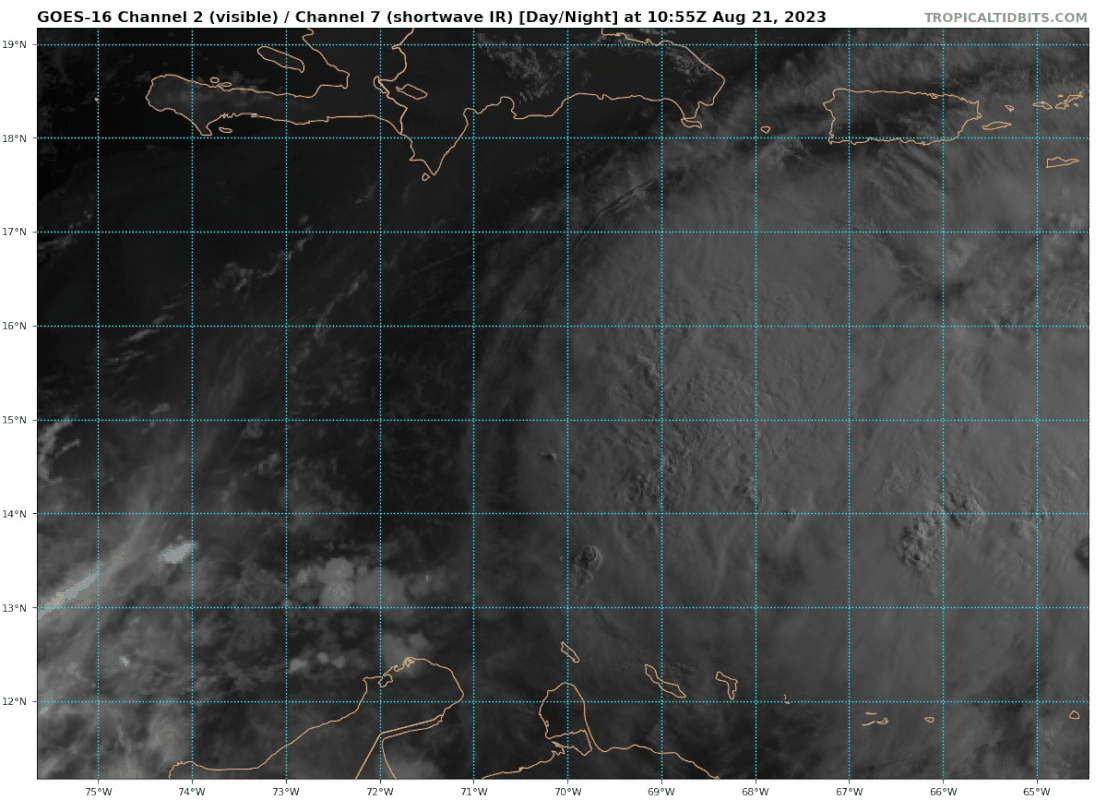
I think Franklin is severely being underestimated right now. ADT has steadily been increasing during the day. Cloud temperature is at almost -80C and raw T# is at 4.4 (981 mb, 75 kt). I don't know how stable Franklin's current structure is, but if it continues to develop like this I think recon might even find hurricane winds.
Current Intensity Analysis
UW - CIMSS
ADVANCED DVORAK TECHNIQUE
ADT-Version 9.1
Tropical Cyclone Intensity Algorithm
----- Current Analysis -----
Date : 21 AUG 2023 Time : 131020 UTC
Lat : 14:59:41 N Lon : 69:49:20 W
CI# /Pressure/ Vmax
4.0 / 983.1mb/ 65.0kt
Final T# Adj T# Raw T#
4.0 4.2 4.4
Center Temp : -77.0C Cloud Region Temp : -79.1C
1 likes
-
ScottNAtlanta

- Category 5

- Posts: 2535
- Joined: Sat May 25, 2013 3:11 pm
- Location: Atlanta, GA
Re: ATL: FRANKLIN - Tropical Storm - Discussion
Looks like the center is on the SW edge of the convection. The center is not under the main convection. It's not stacked. Also, the ULL that is supposed to steer this to the north is situated more in an east/west orientation.
Last edited by ScottNAtlanta on Mon Aug 21, 2023 8:44 am, edited 1 time in total.
0 likes
The posts in this forum are NOT official forecast and should not be used as such. They are just the opinion of the poster and may or may not be backed by sound meteorological data. They are NOT endorsed by any professional institution or storm2k.org. For official information, please refer to the NHC and NWS products.
-
Blown Away
- S2K Supporter
- Posts: 10253
- Joined: Wed May 26, 2004 6:17 am
Re: ATL: FRANKLIN - Tropical Storm - Discussion
ScottNAtlanta wrote:Looks like the center is on the SW edge of the convection. The center is not under the main convection. It's not stacked.
Agree, does it reform to the NE per GFS or continue farther W than track, per a few Icon & Euro runs??
1 likes
Hurricane Eye Experience: David 79, Irene 99, Frances 04, Jeanne 04, Wilma 05… Hurricane Brush Experience: Andrew 92, Erin 95, Floyd 99, Matthew 16, Irma 17, Ian 22, Nicole 22…
-
ScottNAtlanta
- Category 5
- Posts: 2535
- Joined: Sat May 25, 2013 3:11 pm
- Location: Atlanta, GA
Re: ATL: FRANKLIN - Tropical Storm - Discussion
Blown Away wrote:ScottNAtlanta wrote:Looks like the center is on the SW edge of the convection. The center is not under the main convection. It's not stacked.
Agree, does it reform to the NE per GFS or continue farther W than track, per a few Icon & Euro runs??
The ULL that is supposed to be pulling this N is orientated E/W rather than N/S. That might be changing, but right now it is not in a physical orientation to pull it north.
1 likes
The posts in this forum are NOT official forecast and should not be used as such. They are just the opinion of the poster and may or may not be backed by sound meteorological data. They are NOT endorsed by any professional institution or storm2k.org. For official information, please refer to the NHC and NWS products.
-
Iceresistance

- Category 5
- Posts: 9608
- Age: 22
- Joined: Sat Oct 10, 2020 9:45 am
- Location: Tecumseh, OK/Norman, OK
Re: ATL: FRANKLIN - Tropical Storm - Discussion
I wasn't expecting that look from Franklin at all, it's literally destroying Gert with strong wind shear to the NE.
0 likes
Bill 2015 & Beta 2020
Winter 2020-2021
All observations are in Tecumseh, OK unless otherwise noted.
Winter posts are focused mainly for Oklahoma & Texas.
Take any of my forecasts with a grain of salt, refer to the NWS, SPC, and NHC for official information
Never say Never with weather! Because ANYTHING is possible!
Winter 2020-2021
All observations are in Tecumseh, OK unless otherwise noted.
Winter posts are focused mainly for Oklahoma & Texas.
Take any of my forecasts with a grain of salt, refer to the NWS, SPC, and NHC for official information
Never say Never with weather! Because ANYTHING is possible!
-
Blown Away
- S2K Supporter
- Posts: 10253
- Joined: Wed May 26, 2004 6:17 am
Re: ATL: FRANKLIN - Tropical Storm - Discussion
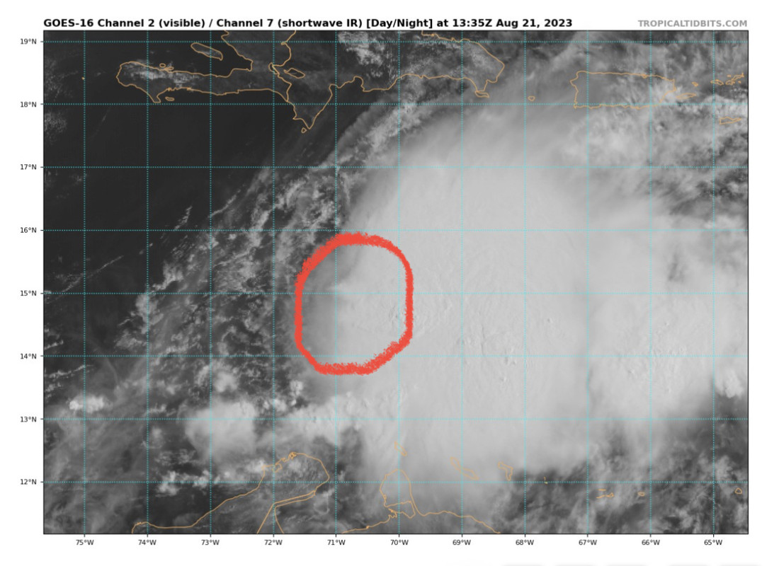
COC is moving faster than convection. NHC says no farther W than 71.2 by tomorrow, but it appears the current COC will blow by that today.
Last edited by Blown Away on Mon Aug 21, 2023 8:54 am, edited 1 time in total.
0 likes
Hurricane Eye Experience: David 79, Irene 99, Frances 04, Jeanne 04, Wilma 05… Hurricane Brush Experience: Andrew 92, Erin 95, Floyd 99, Matthew 16, Irma 17, Ian 22, Nicole 22…
-
WeatherBoy2000
- Category 1
- Posts: 463
- Joined: Mon Apr 10, 2023 9:29 am
Re: ATL: FRANKLIN - Tropical Storm - Discussion
kevin wrote:I think Franklin is severely being underestimated right now. ADT has steadily been increasing during the day. Cloud temperature is at almost -80C and raw T# is at 4.4 (981 mb, 75 kt). I don't know how stable Franklin's current structure is, but if it continues to develop like this I think recon might even find hurricane winds.Current Intensity Analysis
UW - CIMSS
ADVANCED DVORAK TECHNIQUE
ADT-Version 9.1
Tropical Cyclone Intensity Algorithm
----- Current Analysis -----
Date : 21 AUG 2023 Time : 131020 UTC
Lat : 14:59:41 N Lon : 69:49:20 W
CI# /Pressure/ Vmax
4.0 / 983.1mb/ 65.0kt
Final T# Adj T# Raw T#
4.0 4.2 4.4
Center Temp : -77.0C Cloud Region Temp : -79.1C
Caribbean systems have a history of showy convection with little under hood. I highly suspect that this is the case here, recon will reveal its true nature soon enough.
3 likes
-
Hypercane_Kyle

- Category 5
- Posts: 3465
- Joined: Sat Mar 07, 2015 7:58 pm
- Location: Cape Canaveral, FL
Re: ATL: FRANKLIN - Tropical Storm - Discussion
I am expecting the LLC to redevelop somewhere under the deep convection tomorrow, in line with the GFS and typical of sheered systems undergoing massive convective bursts.
0 likes
My posts are my own personal opinion, defer to the National Hurricane Center (NHC) and other NOAA products for decision making during hurricane season.
-
dexterlabio
- Category 5
- Posts: 3517
- Joined: Sat Oct 24, 2009 11:50 pm
Re: ATL: FRANKLIN - Tropical Storm - Discussion
You all know why a CoC pattern forms, right?
0 likes
Personal Forecast Disclaimer:
The posts in this forum are NOT official forecast and should not be used as such. They are just the opinion of the poster and may or may not be backed by sound meteorological data. They are NOT endorsed by any professional institution or storm2k.org. For official information, please refer to the NHC and NWS products.
The posts in this forum are NOT official forecast and should not be used as such. They are just the opinion of the poster and may or may not be backed by sound meteorological data. They are NOT endorsed by any professional institution or storm2k.org. For official information, please refer to the NHC and NWS products.
-
Sciencerocks
- Category 5
- Posts: 10193
- Age: 40
- Joined: Thu Jul 06, 2017 1:51 am


Re: ATL: FRANKLIN - Tropical Storm - Discussion
cycloneye wrote:IsabelaWeather wrote:When is recon scheduled?
Thia afternoon at 12:30 PM.
Need a good look at this thing its pumping outflow like mad.
Hope it doesn't fill that trough or shear off and run naked toward the gulf.
0 likes
-
Blown Away
- S2K Supporter
- Posts: 10253
- Joined: Wed May 26, 2004 6:17 am
Re: ATL: FRANKLIN - Tropical Storm - Discussion
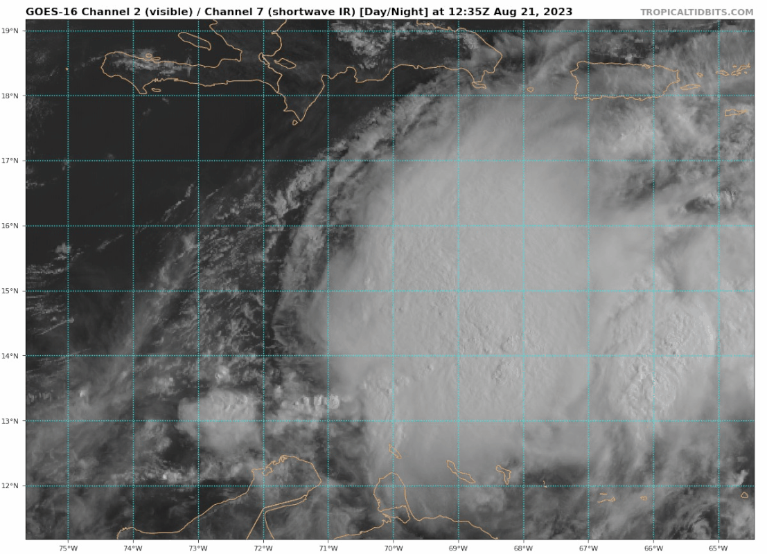
NHC says no farther W than 71.0, clearly see the low level clouds on the W half of COC moving W at a good pace. That COC is going to pop out soon and based on 11am Disco the NHC, even w/ high uncertainty, is predicting NE reform per the GFS.
0 likes
Hurricane Eye Experience: David 79, Irene 99, Frances 04, Jeanne 04, Wilma 05… Hurricane Brush Experience: Andrew 92, Erin 95, Floyd 99, Matthew 16, Irma 17, Ian 22, Nicole 22…
-
Sciencerocks
- Category 5
- Posts: 10193
- Age: 40
- Joined: Thu Jul 06, 2017 1:51 am

Re: ATL: FRANKLIN - Tropical Storm - Discussion
Nimbus wrote:cycloneye wrote:IsabelaWeather wrote:When is recon scheduled?
Thia afternoon at 12:30 PM.
Need a good look at this thing its pumping outflow like mad.
Hope it doesn't fill that trough or shear off and run naked toward the gulf.
Models starting to look Jeanneish with Franklin. If it stayed weak maybe a track like charley?
0 likes

Re: ATL: FRANKLIN - Tropical Storm - Discussion
So far it seems like recon is having trouble finding the LLC. I guess there’s some center reformation shenanigans going on in there. The HWRF was also showing a pretty disorganized system for today in prior runs. If the models are to be believed, we should see the vortex tighten up early tomorrow ahead of landfall in Hispaniola. The broad circulation should help Franklin survive the crossover.
1 likes
Irene '11 Sandy '12 Hermine '16 5/15/2018 Derecho Fay '20 Isaias '20 Elsa '21 Henri '21 Ida '21
I am only a meteorology enthusiast who knows a decent amount about tropical cyclones. Look to the professional mets, the NHC, or your local weather office for the best information.
I am only a meteorology enthusiast who knows a decent amount about tropical cyclones. Look to the professional mets, the NHC, or your local weather office for the best information.
Who is online
Users browsing this forum: No registered users and 34 guests