ATL: IDALIA - Models
Moderator: S2k Moderators
-
toad strangler

- S2K Supporter

- Posts: 4546
- Joined: Sun Jul 28, 2013 3:09 pm
- Location: Earth
- Contact:
Re: ATL: INVEST 93L - Models
Almost all guidance the past 24 hours, even with the swings, has been within the NHC cherry zone. Nothing seemingly amiss yet. That S to N approach is very sensitive in regards to the shape of the eastern GOM coast.
4 likes
My Weather Station
https://www.wunderground.com/dashboard/pws/KFLPORTS603
https://www.wunderground.com/dashboard/pws/KFLPORTS603
-
jlauderdal
- S2K Supporter
- Posts: 7240
- Joined: Wed May 19, 2004 5:46 am
- Location: NE Fort Lauderdale
- Contact:
Re: ATL: INVEST 93L - Models
toad strangler wrote:Almost all guidance the past 24 hours, even with the swings, has been within the NHC cherry zone. Nothing seemingly amiss yet. That S to N approach is very sensitive in regards to the shape of the eastern GOM coast.
Toad makes a good point, very small deviations now make a big difference over time as to who gets the "core"...2 hours of motion "off-track" and you have to do a new track.
3 likes
-
Blown Away

- S2K Supporter
- Posts: 10253
- Joined: Wed May 26, 2004 6:17 am
Re: ATL: INVEST 93L - Models
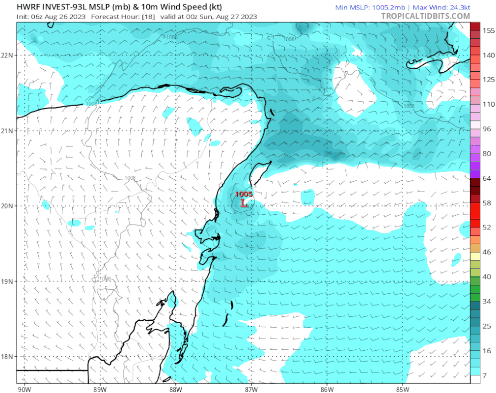
06z HWRF… Way E into Ft Myers and across the peninsula.
1 likes
Hurricane Eye Experience: David 79, Irene 99, Frances 04, Jeanne 04, Wilma 05… Hurricane Brush Experience: Andrew 92, Erin 95, Floyd 99, Matthew 16, Irma 17, Ian 22, Nicole 22…
Re: ATL: INVEST 93L - Models
Blown Away wrote:[url]https://i.postimg.cc/pXzhqdFh/hwrf-mslp-wind-93-L-fh18-99.gif [/url]
06z HWRF… Way E into Ft Myers and across the peninsula.
That looks like an absolute out to lunch run. I see nothing in the synoptics that would cause this to take off due NE. Further, based on buoy pressure drops, their center seems way West
1 likes
-
tolakram
- Admin

- Posts: 20179
- Age: 62
- Joined: Sun Aug 27, 2006 8:23 pm
- Location: Florence, KY (name is Mark)
Re: ATL: INVEST 93L - Models
Hurricane model landfalls.


Globals


Globals
1 likes
M a r k
- - - - -
Join us in chat: Storm2K Chatroom Invite. Android and IOS apps also available.
The posts in this forum are NOT official forecasts and should not be used as such. Posts are NOT endorsed by any professional institution or STORM2K.org. For official information and forecasts, please refer to NHC and NWS products.

-
lsuhurricane
- Category 1

- Posts: 270
- Joined: Tue Aug 15, 2017 2:53 pm
Re: ATL: INVEST 93L - Models
06z Euro is about 50 miles west of the 0z run at the same time stamp (90 vs 96 hours)
0 likes

Re: ATL: INVEST 93L - Models
Lol all we know is that it's probably a Florida landfall. But besides that it's still a big question mark.
0 likes
-
jlauderdal
- S2K Supporter
- Posts: 7240
- Joined: Wed May 19, 2004 5:46 am
- Location: NE Fort Lauderdale
- Contact:
-
skillz305
- Category 1
- Posts: 312
- Joined: Sat Sep 08, 2018 11:10 am
- Location: Miami, Florida --> Vero Beach, Florida
Re: ATL: INVEST 93L - Models
I’d say the HWRF is an extreme outlier but honestly nobody can pinpoint this down right now. We just don’t know. Everyone should be Hurricane prepped already regardless of location in Florida.
2 likes
 Hurricanes: Andrew 1992 - Irene 1999 - Frances 2004 - Jeanne 2004 - Katrina 2005 - Wilma 2005 - Matthew 2016 - Irma 2017 - Ian 2022 - Nicole 2022 - Milton 2024
-
SFLcane

- S2K Supporter
- Posts: 10281
- Age: 48
- Joined: Sat Jun 05, 2010 1:44 pm
- Location: Lake Worth Florida
Re: ATL: INVEST 93L - Models
Hwrf isn’t the only model moving over Cuba.
https://twitter.com/ericburriswesh/status/1695389267583783097
https://twitter.com/ericburriswesh/status/1695389267583783097
1 likes
Re: ATL: INVEST 93L - Models
SFLcane wrote:Hwrf isn’t the only model moving over Cuba.
https://twitter.com/ericburriswesh/status/1695389267583783097?s=46&t=sStb56JhzYdUjITqDzKFmQ
And stronger too!! Looks like it likes the mlc better! That lath would probably be towards tampa down to sarasota.
0 likes
-
cycloneye

- Admin
- Posts: 149275
- Age: 69
- Joined: Thu Oct 10, 2002 10:54 am
- Location: San Juan, Puerto Rico
Re: ATL: INVEST 93L - Models
The hurricane models more to the right at 12z.

0 likes
Visit the Caribbean-Central America Weather Thread where you can find at first post web cams,radars
and observations from Caribbean basin members Click Here
and observations from Caribbean basin members Click Here


-
Spacecoast

- Category 2

- Posts: 773
- Joined: Thu Aug 31, 2017 2:03 pm


Re: ATL: INVEST 93L - Models
Ukmet likes Appalachicola. It was spot on with Ian and Irma
Last edited by robbielyn on Sat Aug 26, 2023 10:51 am, edited 2 times in total.
1 likes
Robbielyn McCrary
I know just about enough to sound like I know what I'm talking about sometimes. But for your safety please follow the nhc for truly professional forecasting.
I know just about enough to sound like I know what I'm talking about sometimes. But for your safety please follow the nhc for truly professional forecasting.

-
jlauderdal
- S2K Supporter
- Posts: 7240
- Joined: Wed May 19, 2004 5:46 am
- Location: NE Fort Lauderdale
- Contact:
Re: RE: Re: ATL: INVEST 93L - Models
The UKMet was good toorobbielyn wrote:
Unmet likes Panama City. It was spot on with Ian and Irma
2 likes

Re: ATL: INVEST 93L - Models
Blown Away wrote:[url]https://i.postimg.cc/pXzhqdFh/hwrf-mslp-wind-93-L-fh18-99.gif [/url]
06z HWRF… Way E into Ft Myers and across the peninsula.
Out to lunch for sure. This would mean the landfall in the Keys as a strengthening hurricane.
While highly unlikely, this could get left behind off the SE CONUS and then pushed SW back into Florida as high pressure builds in...so 3 potential landfalls in Florida. I think it was the Euro showing it being left off the SE CONUS as high pressure starts to build to its northeast.
0 likes
-
chris_fit

- Category 5

- Posts: 3261
- Age: 43
- Joined: Wed Sep 10, 2003 11:58 pm
- Location: Tampa Bay Area, FL
Re: ATL: INVEST 93L - Models
12Z GFS running. No drastic changes through 54 hours... keeps it in the same spot, roughly where it is now.
0 likes
Who is online
Users browsing this forum: No registered users and 28 guests