WPAC: MAWAR - Post-Tropical

Moderator: S2k Moderators

Message
Author
User avatar
Blown Away
S2K Supporter
S2K Supporter
Posts: 10145
Joined: Wed May 26, 2004 6:17 am

Re: WPAC: MAWAR - Typhoon

#161 Postby Blown Away » Mon May 22, 2023 10:39 pm

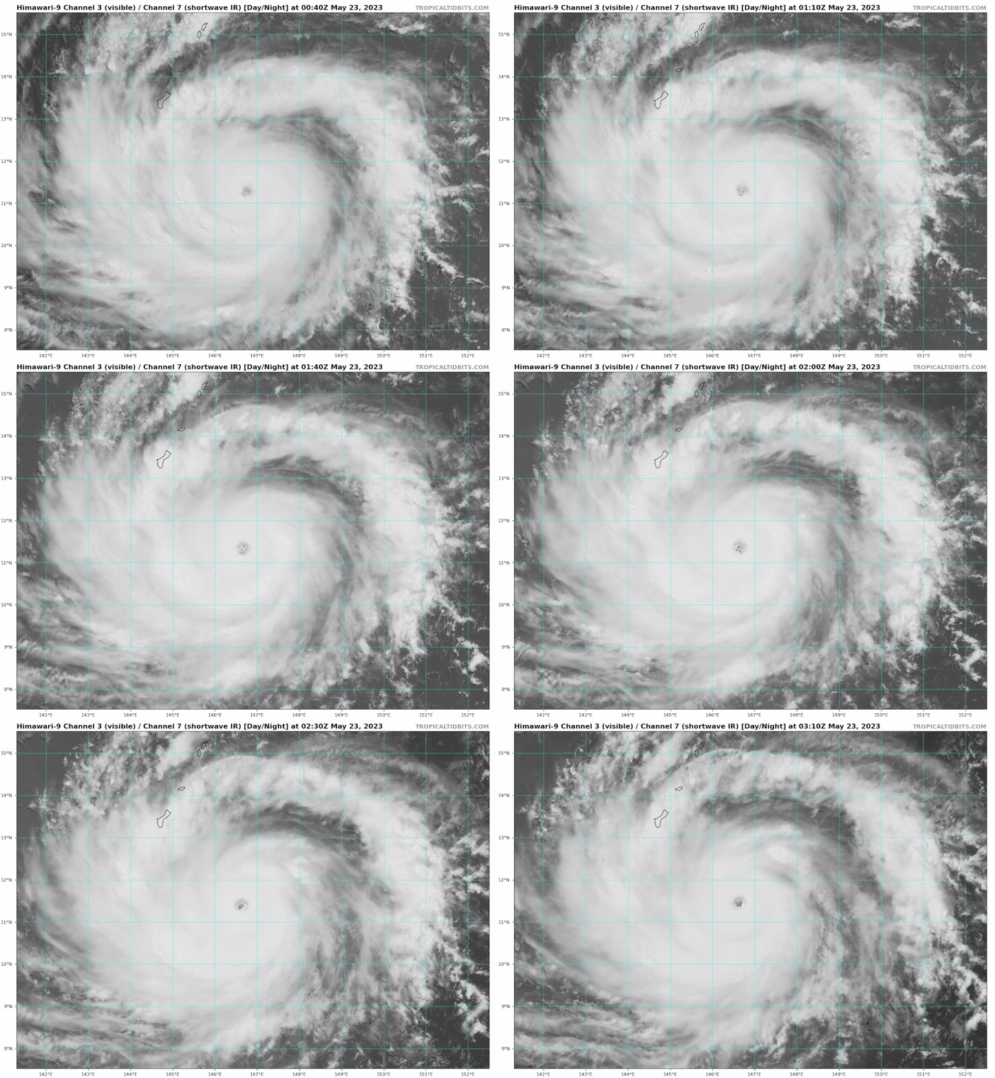
Image

Eye clearing out, wobbling N, looks like direct hit on Guam increasing…
5 likes   
Hurricane Eye Experience: David 79, Irene 99, Frances 04, Jeanne 04, Wilma 05... EYE COMING MY WAY IN 2024…
Hurricane Brush Experience: Andrew 92, Erin 95, Floyd 99, Matthew 16, Irma 17, Ian 22, Nicole 22…

User avatar
Yellow Evan
Professional-Met
Professional-Met
Posts: 16143
Age: 27
Joined: Fri Jul 15, 2011 12:48 pm
Location: Henderson, Nevada/Honolulu, HI
Contact:

Re: WPAC: MAWAR - Typhoon

#162 Postby Yellow Evan » Mon May 22, 2023 10:49 pm

Eye temperature 20C now. Given the eye is circular and uniformly warm, this is an easy Category 5 atp.
3 likes   

User avatar
mrbagyo
Category 5
Category 5
Posts: 3715
Age: 33
Joined: Thu Apr 12, 2012 9:18 am
Location: 14.13N 120.98E
Contact:

Re: WPAC: MAWAR - Typhoon

#163 Postby mrbagyo » Mon May 22, 2023 10:52 pm

Rapid Scan
Image
5 likes   
The posts in this forum are NOT official forecast and should not be used as such. They are just the opinion of the poster and may or may not be backed by sound meteorological data. They are NOT endorsed by any professional institution or storm2k.org. For official information, please refer to RSMC, NHC and NWS products.

Guamphoon
Tropical Low
Tropical Low
Posts: 32
Joined: Wed Jul 04, 2018 11:57 am
Location: Tamuning, Guam

Re: WPAC: MAWAR - Typhoon

#164 Postby Guamphoon » Mon May 22, 2023 11:04 pm

mrbagyo wrote:Rapid Scan
https://i.imgur.com/duJCubp.gif


Wow, that eye is like a washing machine. That is impressive and a bit concerning.

It is completely calm outside now. Not even the palms are swaying. That is gonna change fast I am sure.

Seems like NWS and JTWC underestimated a storm again, I now think a strong CAT4 landfall is likely and CAT5 is certainly not impossible at this point.
3 likes   

MarioProtVI
Category 4
Category 4
Posts: 935
Age: 24
Joined: Sun Sep 29, 2019 7:33 pm
Location: New Jersey

Re: WPAC: MAWAR - Typhoon

#165 Postby MarioProtVI » Tue May 23, 2023 12:41 am

This blew up fast, last time I checked it was still having a bursting CCC pattern. Seemed that resolved quickly. Looks like another Yutu ‘18 is on board but possibly worse…cat 5 likely at 06z methinks
0 likes   

User avatar
InfernoFlameCat
Category 5
Category 5
Posts: 2102
Age: 22
Joined: Mon Dec 14, 2020 10:52 am
Location: Buford, GA

Re: WPAC: MAWAR - Typhoon

#166 Postby InfernoFlameCat » Tue May 23, 2023 12:48 am

they have it at 120 knots now with 942mb.
a bit low imho.
0 likes   
I am by no means a professional. DO NOT look at my forecasts for official information or make decisions based on what I post.

Goal: to become a registered expert over tropical and subtropical cyclones.

Sciencerocks
Category 5
Category 5
Posts: 9155
Age: 39
Joined: Thu Jul 06, 2017 1:51 am

Re: WPAC: MAWAR - Typhoon

#167 Postby Sciencerocks » Tue May 23, 2023 1:19 am

0 likes   

User avatar
TyphoonNara
Category 1
Category 1
Posts: 369
Age: 25
Joined: Tue Dec 04, 2018 9:41 am
Location: Hong Kong

Re: WPAC: MAWAR - Typhoon

#168 Postby TyphoonNara » Tue May 23, 2023 1:39 am

02W MAWAR 230523 0600 11.8N 146.5E WPAC 135 926

135kt is about right for this update, given that wind speeds tend to lag behind satellite presentation. Though I would be disappointed if JTWC doesn't assess the storm to be 150kt+ for the next update given the storm's impressive WMG+CMG presentation.
3 likes   

User avatar
xtyphooncyclonex
Category 5
Category 5
Posts: 3861
Age: 23
Joined: Sat Dec 08, 2012 9:07 am
Location: Cebu City
Contact:

Re: WPAC: MAWAR - Typhoon

#169 Postby xtyphooncyclonex » Tue May 23, 2023 1:57 am

Already up to 100 kt/935 on the JMA. Violent typhoon is expected with the eye in the southern half and the right front quadrant over the rest of the island. Stronger than Pongsona already and it's not done yet. My goodness.

Code: Select all

T2302(Mawar)
Issued at 2023/05/23 06:45 UTC
Analysis at 05/23 06 UTC
Grade   TY
Scale   -
Intensity   Very Strong
Center position   N11°50′ (11.8°)
E146°30′ (146.5°)
Direction and speed of movement   N 15 km/h (7 kt)
Central pressure   935 hPa
Maximum sustained wind speed near center   50 m/s (100 kt)
Maximum wind gust speed   70 m/s (140 kt)
Radius of 50-kt wind area   130 km (70 NM)
Radius of 30-kt wind area   390 km (210 NM)

Forecast for 05/24 06 UTC
Grade   TY
Intensity   Violent
Center position of probability circle   N13°30′ (13.5°)
E144°35′ (144.6°)
Direction and speed of movement   NW 10 km/h (6 kt)
Central pressure   910 hPa
Maximum sustained wind speed near center   [55 m/s (110 kt)
Maximum wind gust speed   80 m/s (155 kt)
Radius of probability circle   65 km (35 NM)
Radius of storm warning area   230 km (125 NM)
1 likes   
REMINDER: My opinions that I, or any other NON Pro-Met in this forum, are unofficial. Please do not take my opinions as an official forecast and warning. I am NOT a meteorologist. Following my forecasts blindly may lead to false alarm, danger and risk if official forecasts from agencies are ignored.

Sciencerocks
Category 5
Category 5
Posts: 9155
Age: 39
Joined: Thu Jul 06, 2017 1:51 am

Re: WPAC: MAWAR - Typhoon

#170 Postby Sciencerocks » Tue May 23, 2023 2:03 am

0 likes   

User avatar
ElectricStorm
Category 5
Category 5
Posts: 5044
Age: 24
Joined: Tue Aug 13, 2019 11:23 pm
Location: Skiatook, OK / Norman, OK

Re: WPAC: MAWAR - Typhoon

#171 Postby ElectricStorm » Tue May 23, 2023 3:07 am

New JTWC forecast with a double Cat 5 peak
Image
0 likes   
B.S Meteorology, University of Oklahoma '25

Please refer to the NHC, NWS, or SPC for official information.

User avatar
doomhaMwx
Category 5
Category 5
Posts: 2454
Age: 26
Joined: Tue Apr 18, 2017 4:01 am
Location: Baguio/Benguet, Philippines
Contact:

Re: WPAC: MAWAR - Typhoon

#172 Postby doomhaMwx » Tue May 23, 2023 3:29 am

Looks like intensification has already come to a halt due to EWRC (latest IR imagery shows convection in the eyewall warming up). Even so, this is still looking to become the worst storm to impact Guam in decades!

Image

 https://twitter.com/wxjerdman/status/1660963785014755329


Last edited by doomhaMwx on Tue May 23, 2023 7:12 am, edited 1 time in total.
3 likes   

Guamphoon
Tropical Low
Tropical Low
Posts: 32
Joined: Wed Jul 04, 2018 11:57 am
Location: Tamuning, Guam

Re: WPAC: MAWAR - Typhoon

#173 Postby Guamphoon » Tue May 23, 2023 3:42 am

Sun has just set. Getting a little bit breezier than a few hours ago, but nothing remarkable. No rain. Just overcast. Clouds seem in a hurry though. What happens with Mawar tonight is gonna affect the whole island.

EWRC is a break we needed. But hopefully it didn't come too early.
2 likes   

User avatar
Hayabusa
Category 5
Category 5
Posts: 4349
Joined: Sun Sep 16, 2018 1:05 pm

Re: WPAC: MAWAR - Typhoon

#174 Postby Hayabusa » Tue May 23, 2023 4:35 am

JMA is forecasting this to be near Surigae strength only 5 knots/5 mb difference
Forecast for 05/27 06 UTC
Grade TY
Intensity Violent
Center position of probability circle N16°35′ (16.6°)
E131°30′ (131.5°)
Direction and speed of movement W 25 km/h (13 kt)
Central pressure 900 hPa
Maximum sustained wind speed near center 60 m/s (115 kt)
Maximum wind gust speed 85 m/s (165 kt)
Radius of probability circle 260 km (140 NM)
Radius of storm warning area 520 km (280 NM)
0 likes   
ヤンデレ女が寝取られるているのを見たい!!!
ECMWF ensemble NWPAC plots: https://ecmwfensnwpac.imgbb.com/
Multimodel NWPAC plots: https://multimodelnwpac.imgbb.com/
GFS Ensemble NWPAC plots (16 & 35 day forecast): https://gefsnwpac.imgbb.com/
Plots updated automatically

User avatar
Hayabusa
Category 5
Category 5
Posts: 4349
Joined: Sun Sep 16, 2018 1:05 pm

Re: WPAC: MAWAR - Typhoon

#175 Postby Hayabusa » Tue May 23, 2023 4:36 am

00Z
Image
0 likes   
ヤンデレ女が寝取られるているのを見たい!!!
ECMWF ensemble NWPAC plots: https://ecmwfensnwpac.imgbb.com/
Multimodel NWPAC plots: https://multimodelnwpac.imgbb.com/
GFS Ensemble NWPAC plots (16 & 35 day forecast): https://gefsnwpac.imgbb.com/
Plots updated automatically

User avatar
cycloneye
Admin
Admin
Posts: 145285
Age: 68
Joined: Thu Oct 10, 2002 10:54 am
Location: San Juan, Puerto Rico

Re: WPAC: MAWAR - Typhoon

#176 Postby cycloneye » Tue May 23, 2023 4:55 am

WDPN31 PGTW 230900
MSGID/GENADMIN/JOINT TYPHOON WRNCEN PEARL HARBOR HI//
SUBJ/PROGNOSTIC REASONING FOR SUPER TYPHOON 02W (MAWAR) WARNING NR
014//
RMKS/
1. FOR METEOROLOGISTS.
2. 6 HOUR SUMMARY AND ANALYSIS.

SUMMARY:
INITIAL POSITION: 11.8N 146.5E
INITIAL INTENSITY: 135 KTS
GEOGRAPHIC REFERENCE: 148 NM SOUTHEAST OF ANDERSEN AFB
MOVEMENT PAST 6 HOURS: NORTH-NORTHWESTWARD AT 07 KTS
SIGNIFICANT WAVE HEIGHT: 45 FEET

SATELLITE ANALYSIS, INITIAL POSITION AND INTENSITY DISCUSSION:
ANIMATED MULTISPECTRAL SATELLITE IMAGERY (MSI) DEPICTS THE CLASSIC,
SYMMETRIC CLOUD PATTERN TYPICAL OF A SUPER TYPHOON, WITH AN OUTER
BAND ALONG THE NORTHERN AND WESTERN PERIPHERIES CURRENTLY
APPROACHING GUAM AND THE NORTHERN MARIANA ISLANDS. THE INITIAL
POSITION IS PLACED WITH HIGH CONFIDENCE BASED ON AN APPROXIMATELY
15-20 NM DIAMETER EYE EVIDENT IN BOTH RADAR AND GEOSTATIONARY
SATELLITE IMAGERY. THE INITIAL INTENSITY OF 135 KNOTS IS ASSESSED
WITH HIGH CONFIDENCE BASED ON SUBJECTIVE DVORAK ESTIMATES,
OBJECTIVE DVORAK AND SATELLITE CONSENSUS BASED INTENSITIES, AND
RADAR VELOCITY DATA. WHILE AN EARLIER EYEWALL REPLACEMENT CYCLE
(ERC) APPEARS TO HAVE COMPLETED, RECENT RADAR IMAGERY INDICATES
FORMATION OF A NEW INNER BAND THAT COULD BE THE PRECURSOR OF
ANOTHER ERC IN THE HOURS AHEAD.

INITIAL WIND RADII BASIS: OBJECTIVE BEST TRACK AND RADAR VELOCITY
DATA

CURRENT STEERING MECHANISM: SUBTROPICAL RIDGING (STR) TO THE NORTH
AND EAST

AGENCY DVORAK AND AUTOMATED FIXES:
PGTW: T7.0 - 140 KTS
RJTD: T6.5 - 127 KTS
KNES: T7.0 - 140 KTS
CIMSS SATCON: 129 KTS AT 230319Z
CIMSS ADT: 134 KTS AT 230530Z

FORECASTER ASSESSMENT OF CURRENT ENVIRONMENT: HIGHLY FAVORABLE
VWS: 10-15 KTS
SST: 29-30 CELSIUS
OUTFLOW: STRONG POLEWARD AND EQUATORWARD

ANALYSIS CONFIDENCE:
INITIAL POSITION: HIGH
INITIAL INTENSITY: HIGH
INITIAL WIND RADII: MEDIUM

3. FORECAST REASONING.

SIGNIFICANT FORECAST CHANGES: ANALYZED WIND RADII HAVE EXPANDED
RELATIVE TO THE PREVIOUS WARNING. HOWEVER, THERE ARE NO SIGNIFICANT
CHANGES TO THE FORECAST FROM THE PREVIOUS WARNING.

FORECAST DISCUSSION: STY MAWAR CONTINUES TO UNDERGO RAPID
INTENSIFICATION, SUPPORTED BY VERY FAVORABLE UPPER LEVEL CONDITIONS
AND A WARM SEA SURFACE. THE PRIMARY INHIBITOR TO ADDITIONAL
NEAR-TERM INTENSIFICATION IS THE IMPACT OF INNER-CORE DYNAMICS
INCLUDING THE POSSIBILITY OF AN EYEWALL REPLACEMENT CYCLE. THE
CURRENT FORECAST CALLS FOR MARGINAL INTENSIFICATION TO 140 KNOTS
OVER THE NEXT 12 HOURS, AND IT IS ALL BUT CERTAIN THAT THE SYSTEM
WILL REMAIN AT OR NEAR SUPER TYPHOON INTENSITY PRIOR TO PASSAGE OF
THE EYE OVER OR NEAR GUAM. THE SYSTEM WILL TURN INCREASINGLY TOWARD
A WEST-NORTHWESTWARD TRACK OVER THE NEXT 24 HOURS AS SUBTROPICAL
RIDGING BUILDS ON THE POLEWARD SIDE OF THE SYSTEM. THE SYSTEM WILL
FOLLOW SOLIDLY ENTRENCHED FLOW ASSOCIATED WITH THE STR THROUGHOUT
THE FORECAST PERIOD, APPROACHING THE RIDGE AXIS AROUND TAU 120.
ENVIRONMENTAL CONDITIONS WILL REMAIN FAVORABLE ALONG THE STORM
TRACK FOR THE NEXT FIVE DAYS, ENABLING THE SYSTEM TO REMAIN A
FORMIDABLE TYPHOON.

MODEL DISCUSSION: NUMERICAL MODEL TRACK FORECAST GUIDANCE IS IN
VERY GOOD AGREEMENT THROUGH TAU 24, LEAVING LITTLE DOUBT THAT GUAM
IS IN FOR A DIRECT OR NEARLY-DIRECT HIT FROM SUPER TYPHOON MAWAR.
MODEL GUIDANCE IS ALSO IN AGREEMENT REGARDING THE ANTICIPATED
INTENSIFY AT OR NEAR SUPER TYPHOON STATUS. BEYOND TAU 24, THE
GENERAL TREND IN BOTH THE TRACK AND INTENSITY FORECASTS ARE SIMILAR
AMONG THE PRIMARY MODELS. MOST OF THE UNCERTAINTY IN THE TRACK
FORECAST LIES IN THE CROSS-TRACK DIRECTION - ALONG TRACK SPEEDS
AMONG THE SOLUTIONS ARE VERY CLOSE. NEAR-TERM TRACK FORECAST
CONFIDENCE IS HIGH BASED ON TIGHT PACKING OF THE MODEL SOLUTIONS
THROUGH TAU 72. CROSS-TRACK SPREAD OF THE GUIDANCE ENVELOPE
INCREASES TO A MODEST 190 NM BY TAU 120, AND THE FORECAST LIES NEAR
THE MULTI-MODEL CONSENSUS IN THE EXTENDED RANGE WITH MEDIUM
CONFIDENCE. INTENSITY FORECAST GUIDANCE, INCLUDING THE HWRF AND
COAMPS-TC MODELS, SUPPORT MAINTENANCE OF STRONG TYPHOON TO SUPER
TYPHOON INTENSITY THROUGHOUT THE FORECAST PERIOD. GIVEN THE ONGOING
POTENTIAL FOR INNER-CORE STRUCTURAL CHANGES AND SOME SPREAD IN
MODEL FORECAST GUIDANCE, CONFIDENCE IN INTENSITY FORECAST IS
MEDIUM.

FORECAST CONFIDENCE:
TRACK 0 - 72 HR: HIGH
TRACK 72-120 HR: MEDIUM
INTENSITY 0 - 72 HR: MEDIUM
INTENSITY 72-120 HR: MEDIUM//
NNNN
0 likes   
Visit the Caribbean-Central America Weather Thread where you can find at first post web cams,radars
and observations from Caribbean basin members Click Here

User avatar
doomhaMwx
Category 5
Category 5
Posts: 2454
Age: 26
Joined: Tue Apr 18, 2017 4:01 am
Location: Baguio/Benguet, Philippines
Contact:

Re: WPAC: MAWAR - Typhoon

#177 Postby doomhaMwx » Tue May 23, 2023 5:09 am

Himawari-9 RGB satellite animation from 05-22 20:00Z to 05-23 08:30Z.

Image
4 likes   

User avatar
doomhaMwx
Category 5
Category 5
Posts: 2454
Age: 26
Joined: Tue Apr 18, 2017 4:01 am
Location: Baguio/Benguet, Philippines
Contact:

Re: WPAC: MAWAR - Typhoon

#178 Postby doomhaMwx » Tue May 23, 2023 6:06 am

Impressive, Guam radar is capturing echo top heights reaching ~17km in the eyewall of Mawar.

Image
5 likes   

User avatar
cycloneye
Admin
Admin
Posts: 145285
Age: 68
Joined: Thu Oct 10, 2002 10:54 am
Location: San Juan, Puerto Rico

Re: WPAC: MAWAR - Typhoon

#179 Postby cycloneye » Tue May 23, 2023 7:31 am

02W MAWAR 230523 1200 12.2N 146.1E WPAC 135 923
0 likes   
Visit the Caribbean-Central America Weather Thread where you can find at first post web cams,radars
and observations from Caribbean basin members Click Here

User avatar
TyphoonNara
Category 1
Category 1
Posts: 369
Age: 25
Joined: Tue Dec 04, 2018 9:41 am
Location: Hong Kong

Re: WPAC: MAWAR - Typhoon

#180 Postby TyphoonNara » Tue May 23, 2023 7:53 am

2 likes   


Return to “2023”

Who is online

Users browsing this forum: Google Adsense [Bot], kevin and 5 guests