ATL: IDALIA - Post-Tropical - Discussion
Moderator: S2k Moderators


Re: ATL: INVEST 93L - Discussion
Cancun and Cozumel now reporting NW winds, pressure still slightly higher than what the buoy reports.
I don't think the NHC expected 93L to be this organized this morning, otherwise they would had scheduled a recon for this at least this afternoon instead of for tomorrow afternoon. I guess the models' forecast of the vorticity moving inland this morning made them make this call.

I don't think the NHC expected 93L to be this organized this morning, otherwise they would had scheduled a recon for this at least this afternoon instead of for tomorrow afternoon. I guess the models' forecast of the vorticity moving inland this morning made them make this call.
1 likes

Re: ATL: INVEST 93L - Discussion
NDG wrote:Cancun and Cozumel now reporting NW winds, pressure still slightly higher than what the buoy reports.
I don't think the NHC expected 93L to be this organized this morning, otherwise they would had scheduled a recon for this at least this afternoon instead of for tomorrow afternoon. I guess the models' forecast of the vorticity moving inland this morning made them make this call.
https://i.imgur.com/fnzZcQ1.jpg
Very compact storm this is going to be!
0 likes
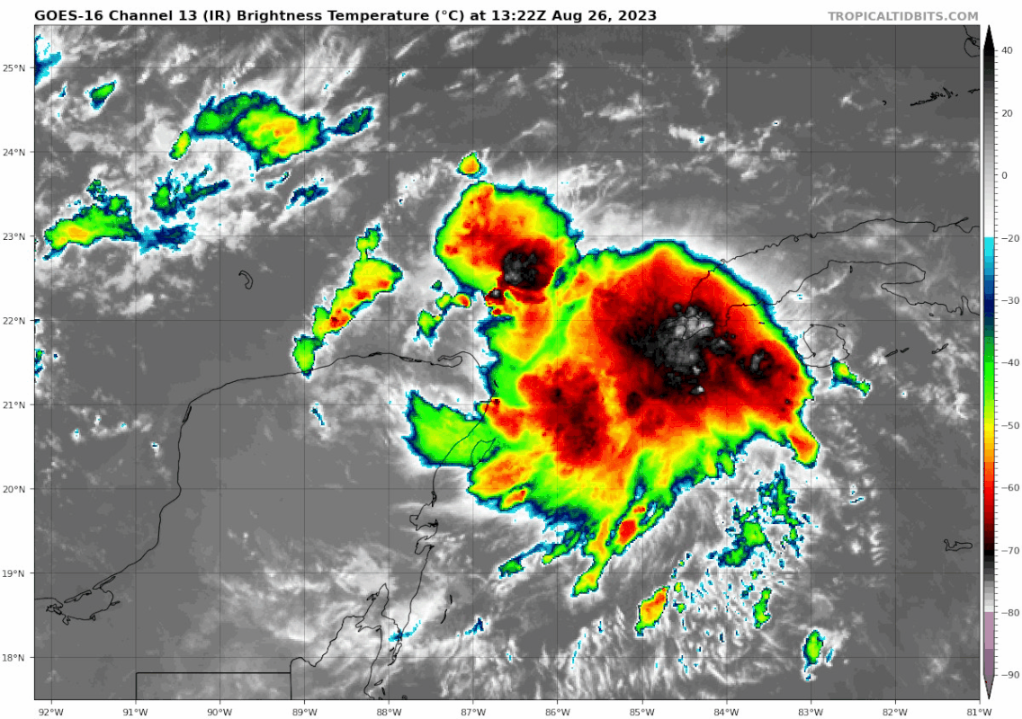
Re: ATL: INVEST 93L - Discussion
21.8N 84.5
IR showing high helicity with increasing colder cloud tops and a possible warm-core signature.
IR showing high helicity with increasing colder cloud tops and a possible warm-core signature.
0 likes
-
wxman57

- Moderator-Pro Met

- Posts: 23175
- Age: 68
- Joined: Sat Jun 21, 2003 8:06 pm
- Location: Houston, TX (southwest)
Re: ATL: INVEST 93L - Discussion
Models have a deepening trof over the NW Gulf by Tuesday and the ridge centered east of the Bahamas. Perfect avenue to track NNE to the FL Peninsula. One thing to watch for is that early forecasts are almost always too far west in these situations. Could move inland south of Tampa on Tuesday vs. Wednesday. Fine with me. It's going to be a sheared system with most squalls east of the center.
8 likes
Re: ATL: INVEST 93L - Discussion
Very interesting 12z sounding from Cancun this morning. You can tell that the H85 vorticity was or is to the south while the ML circulation to the east. You can also see surface winds from the north indicating rightly that the developing LLC is to the east much closer to the MLC.

3 likes
-
SFLcane

- S2K Supporter

- Posts: 10281
- Age: 48
- Joined: Sat Jun 05, 2010 1:44 pm
- Location: Lake Worth Florida
Re: ATL: INVEST 93L - Discussion
wxman57 wrote:Models have a deepening trof over the NW Gulf by Tuesday and the ridge centered east of the Bahamas. Perfect avenue to track NNE to the FL Peninsula. One thing to watch for is that early forecasts are almost always too far west in these situations. Could move inland south of Tampa on Tuesday vs. Wednesday. Fine with me. It's going to be a sheared system with most squalls east of the center.
1 likes
-
SFLcane
- S2K Supporter
- Posts: 10281
- Age: 48
- Joined: Sat Jun 05, 2010 1:44 pm
- Location: Lake Worth Florida
Re: ATL: INVEST 93L - Discussion
wxman57 wrote:Models have a deepening trof over the NW Gulf by Tuesday and the ridge centered east of the Bahamas. Perfect avenue to track NNE to the FL Peninsula. One thing to watch for is that early forecasts are almost always too far west in these situations. Could move inland south of Tampa on Tuesday vs. Wednesday. Fine with me. It's going to be a sheared system with most squalls east of the center.
You always say follow the convention well I find it interesting most of it is drifting towards Cuba. Just an observation
Last edited by SFLcane on Sat Aug 26, 2023 9:41 am, edited 2 times in total.
0 likes

Re: ATL: INVEST 93L - Discussion
SFLcane wrote:wxman57 wrote:Models have a deepening trof over the NW Gulf by Tuesday and the ridge centered east of the Bahamas. Perfect avenue to track NNE to the FL Peninsula. One thing to watch for is that early forecasts are almost always too far west in these situations. Could move inland south of Tampa on Tuesday vs. Wednesday. Fine with me. It's going to be a sheared system with most squalls east of the center.
Most of the models have a Florida panhandle or big bend hit is that trough going to be that strong to force 93 L south of Tampa?
0 likes
-
otowntiger
- Category 5

- Posts: 1932
- Joined: Tue Aug 31, 2004 7:06 pm
Re: ATL: INVEST 93L - Discussion
wxman57 wrote:Models have a deepening trof over the NW Gulf by Tuesday and the ridge centered east of the Bahamas. Perfect avenue to track NNE to the FL Peninsula. One thing to watch for is that early forecasts are almost always too far west in these situations. Could move inland south of Tampa on Tuesday vs. Wednesday. Fine with me. It's going to be a sheared system with most squalls east of the center.
And in that scenario (further east and south landfall) would you also surmise weaker, with less time over water?
0 likes

-
ScottNAtlanta

- Category 5
- Posts: 2535
- Joined: Sat May 25, 2013 3:11 pm
- Location: Atlanta, GA
Re: ATL: INVEST 93L - Discussion
This is going to be a nightmare for the FL homeowners insurance market. It was already getting hard to pay for, but even a Cat1 hit would throw that market into turmoil. That's not to say all the people that don't have it now because it is so expensive.
4 likes
The posts in this forum are NOT official forecast and should not be used as such. They are just the opinion of the poster and may or may not be backed by sound meteorological data. They are NOT endorsed by any professional institution or storm2k.org. For official information, please refer to the NHC and NWS products.

Re: ATL: INVEST 93L - Discussion
NDG wrote:Cancun and Cozumel now reporting NW winds, pressure still slightly higher than what the buoy reports.
I don't think the NHC expected 93L to be this organized this morning, otherwise they would had scheduled a recon for this at least this afternoon instead of for tomorrow afternoon. I guess the models' forecast of the vorticity moving inland this morning made them make this call.
https://i.imgur.com/fnzZcQ1.jpg
Storms like to avoid land if at all possible.
0 likes
Robbielyn McCrary
I know just about enough to sound like I know what I'm talking about sometimes. But for your safety please follow the nhc for truly professional forecasting.
I know just about enough to sound like I know what I'm talking about sometimes. But for your safety please follow the nhc for truly professional forecasting.
Re: ATL: INVEST 93L - Discussion
I'm sounding the "all clear" for tampa bay because it's always clear here. Look out Punta Gorda or Panama city! ( very slight sarcasm flag...and I mean slight). On a slightly more serious note...a peak season "slop storm" can pack a good bit more punch than a June mess. Hermine of '16 could be a good analog. That caused lots of water issues on the west coast and big bend. Definitely watching with interest.
1 likes
Re: ATL: INVEST 93L - Discussion
Good lightning in core and feeder band.
No other MCS around to disrupt its infeed.
VIS show all LL flow over Cancun moving west.
No other MCS around to disrupt its infeed.
VIS show all LL flow over Cancun moving west.
3 likes
Re: ATL: INVEST 93L - Discussion
SFLcane wrote:wxman57 wrote:Models have a deepening trof over the NW Gulf by Tuesday and the ridge centered east of the Bahamas. Perfect avenue to track NNE to the FL Peninsula. One thing to watch for is that early forecasts are almost always too far west in these situations. Could move inland south of Tampa on Tuesday vs. Wednesday. Fine with me. It's going to be a sheared system with most squalls east of the center.
You always say follow the convention well I find it interesting most of it is drifting towards Cuba. Just an observation
https://i.postimg.cc/FsHQ61TG/IMG-7505.gif
I don't see that happening, I don't see a trough digging south and sweeping across the SE US on the EPS & GEFS ensembles as 93L lifts north, that's what usually causes the storms to track more east than forecasted. The short wave trough digs but to the west of the lower MS river Valley and stays in place as a ridge builds just east of FL.
1 likes
Who is online
Users browsing this forum: No registered users and 80 guests