000
WTPZ44 KNHC 180247
TCDEP4
Hurricane Hilary Discussion Number 7
NWS National Hurricane Center Miami FL EP092023
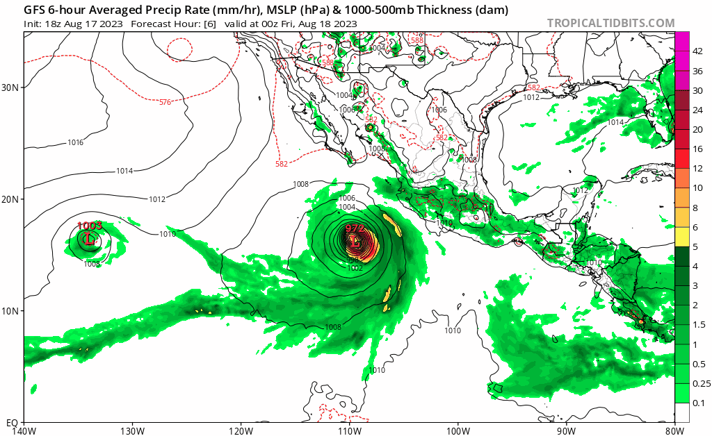
900 PM MDT Thu Aug 17 2023
Hilary continues to rapidly intensify. The presentation on infrared
satellite imagery has become very impressive, and the hurricane now
has a thick ring of -70 to -75 C eyewall cloud tops surrounding the
eye which continues to warm. Earlier AMSR2 and GMI microwave imagery
showed a similarly impressive structure, with a solid eyewall on
both 89-GHz and 37-GHz channels. While the most recent subjective
Dvorak intensity estimates are constrained from increasing as much
as the satellite presentation would suggest, the objective estimates
from UW-CIMSS have been rapidly increasing, with the latest
estimate from ADT at T6.3/122 kt, AiDT at 112 kt, and 107 kt from
D-PRINT. Hilda's initial intensity will be set at 110 kt for this
advisory, favoring the objective estimates.
The hurricane has maintained a west-northwestward motion tonight,
estimated at 300/12 kt. The mid-level ridge currently steering Hilda
is soon forecast to shift eastward as a mid- to upper-level cutoff
low swings in from the west and parks itself near the central
California coast. This pattern should result in Hilary starting to
turn northwestward and the north-northwestward over the next 24-36
hours. A turn more northward should begin by this weekend with some
gradual acceleration as the hurricane is captured downstream of the
cutoff low. The track guidance this cycle remains tightly
clustered, and only slight adjustments to the forecast track were
made this cycle. This track forecast remains in good agreement with
the corrected consensus aid (HCCA). Since the forecast track
continues to be roughly parallel to the coastline north of the
central Baja peninsula to the California border, it very difficult
to know if the center will remain just offshore or move over the
peninsula before reaching the southwestern United States.
The rapid intensification episode of Hilary is expected to continue
for at least another 12 hours, and the latest forecast intensity now
takes the hurricane to 130 kt in that time frame. Afterwards, there
is an interesting difference between the statistical-dynamical
models (SHIPS and LGEM) which show a peak intensity in about 24
hours, and the hurricane-regional models which show a peak a bit
earlier before gradual weakening begins. While there are few signs
of an imminent eyewall replacement cycle based on the last few
microwave passes, it is possible one could occur in another day or
so. The large 34-kt wind field of the hurricane could also start to
upwell some cooler waters out ahead of the inner core in 24-36
hours. Thus, some gradual weakening is now forecast to begin during
this time period with a faster rate of weakening as the hurricane
crosses a sharp temperature gradient to the west of the Baja
Californian peninsula. The official forecast is above the intensity
guidance in the short-term, but falls back to the consensus aids
beyond 36 h. The surface circulation is likely to dissipate as it
pushes far inland in 96 hours, but a point as a remnant low will
still be shown to maintain a forecast track over the southwestern
United States.
KEY MESSAGES:
1. Heavy rainfall associated with Hilary may produce areas of flash
flooding and result in landslides over portions of the Baja
California Peninsula from late Friday into late Sunday. Rainfall
impacts from Hilary within the Southwestern United States are
expected to peak this weekend into Monday. Flash, urban, and arroyo
flooding is possible with the potential for significant impacts.
2. The threat of hurricane-force wind impacts is increasing along
the west-central coast of the Baja California Peninsula, and the
government of Mexico has issued a hurricane watch for a portion of
the west coast of the Baja California peninsula. Tropical storm
conditions are expected to spread across the southern portion of the
Baja California Peninsula by late Friday where a Tropical Storm
Warning is in effect.
3. The threat of significant wind impacts continues to increase for
the northern portions of the Baja California Peninsula and the
Southwestern United States, especially in areas of mountainous
terrain. Although it is too soon to determine the location and
magnitude of these impacts, interests in these areas should monitor
the progress of Hilary and updates to the forecast. Watches could
be issued for portions of this area on Friday.
4. Large swells from Hilary will spread northward along the coast
of southwestern Mexico and the Baja California Peninsula. These
swells will reach the Gulf of California and northern portions of
the Baja California Peninsula later this weekend.
FORECAST POSITIONS AND MAX WINDS
INIT 18/0300Z 16.7N 110.0W 110 KT 125 MPH
12H 18/1200Z 17.7N 111.4W 130 KT 150 MPH
24H 19/0000Z 19.4N 112.6W 125 KT 145 MPH
36H 19/1200Z 21.5N 113.6W 115 KT 130 MPH
48H 20/0000Z 24.0N 114.3W 100 KT 115 MPH
60H 20/1200Z 27.2N 115.0W 70 KT 80 MPH
72H 21/0000Z 30.7N 116.1W 55 KT 65 MPH
96H 22/0000Z 39.0N 118.3W 25 KT 30 MPH...POST-TROP/REMNT LOW
120H 23/0000Z...DISSIPATED
$$
Forecaster Papin