ATL: IDALIA - Post-Tropical - Discussion

Moderator: S2k Moderators

Message
Author
User avatar
aspen
Category 5
Category 5
Posts: 8818
Joined: Sat Oct 12, 2019 7:10 pm
Location: Connecticut, USA

Re: ATL: IDALIA - Hurricane - Discussion

#1901 Postby aspen » Tue Aug 29, 2023 7:59 am

Teban54 wrote:So since the two passes had the same pressure and somewhat similar spread of wind field, what exactly was Idalia doing between the passes? Not that I'm impatient...

I’m guessing sorting out its core. The VDM reported a spiral band eye structure, and the eyewall is a little messy on radar. The hurricane models show this’ll take a few more hours. I’m expecting a faster rate of intensification to pick up early this afternoon.
Last edited by aspen on Tue Aug 29, 2023 8:04 am, edited 1 time in total.
2 likes   
Irene '11 Sandy '12 Hermine '16 5/15/2018 Derecho Fay '20 Isaias '20 Elsa '21 Henri '21 Ida '21

I am only a meteorology enthusiast who knows a decent amount about tropical cyclones. Look to the professional mets, the NHC, or your local weather office for the best information.

User avatar
GCANE
S2K Supporter
S2K Supporter
Posts: 11500
Joined: Mon Oct 22, 2007 8:03 am

Re: ATL: IDALIA - Hurricane - Discussion

#1902 Postby GCANE » Tue Aug 29, 2023 8:02 am

The biggest CAPE gradient is around 25N.
I am thinking it will RI there.
Was thinking that yesterday as well.
Wait and see.
1 likes   

SecondBreakfast
Tropical Storm
Tropical Storm
Posts: 102
Joined: Sun Sep 10, 2017 7:14 am
Location: NYC/LI

Re: ATL: IDALIA - Hurricane - Discussion

#1903 Postby SecondBreakfast » Tue Aug 29, 2023 8:10 am

Extratropical94 wrote:
ScottNAtlanta wrote:MESOCYCLONE INDICATED ON RADAR - 360 / 10NM FROM CTR

What does that mean?


They noticed a rotating supercell 10 nautical miles north of Idalia's center on their radar. A good indicator that Idalia's circulation is capable of spawning tornadoes


This is what I am most worried about for my family in the Orlando area.
0 likes   
Biologist by training, weather enthusiast for life.

User avatar
sponger
S2K Supporter
S2K Supporter
Posts: 1620
Joined: Thu Jul 22, 2004 11:26 am
Location: St Augustine

Re: ATL: IDALIA - Hurricane - Discussion

#1904 Postby sponger » Tue Aug 29, 2023 8:13 am

tolakram wrote:How many gulf landfalling storms have been underestimated in the last 5 years? I read some overnight posts once again thinking this won't be as strong as forecast. :lol: Fortunately I think most people on here are taking this storm very seriously, especially after last year. We can always hope Idalia will end the trend of hurricanes strengthening all the way until landfall, but I would not bet on it.


Nor the trend of hooking right early when they do bomb out!
0 likes   
The following post is NOT an official forecast and should not be used as such. It is just the opinion of the poster and may or may not be backed by sound meteorological data. It is NOT endorsed by any professional institution including storm2k.org For Official Information please refer to the NHC and NWS products.

User avatar
gatorcane
S2K Supporter
S2K Supporter
Posts: 23691
Age: 47
Joined: Sun Mar 13, 2005 3:54 pm
Location: Boca Raton, FL

Re: ATL: IDALIA - Hurricane - Discussion

#1905 Postby gatorcane » Tue Aug 29, 2023 8:13 am

How far east of the track is it, can somebody post a graphic?
0 likes   

User avatar
HurricaneEnzo
Category 2
Category 2
Posts: 739
Joined: Wed Mar 14, 2018 12:18 pm
Location: Newport, NC (Hurricane Alley)

Re: ATL: IDALIA - Hurricane - Discussion

#1906 Postby HurricaneEnzo » Tue Aug 29, 2023 8:16 am

Agreed. The center is going to wobble around as it establishes itself. I'm expecting it to wobble back West again and essentially end up right where the NHC had it aka overall motion. .3 does not a trend make sorry. And I may end up eating crow with more data but already looks like it may be fixing to wobble back west a bit on radar.


SFLcane wrote:
NDG wrote:No way Idalia is moving straight due north this morning. I wouldn't rule out landfall closer to Cedar Key than shown by the models.

https://i.imgur.com/LBxCqTR.gif


It’s right on the nhc track convection can be deceiving.

https://i.postimg.cc/6qkNPGy6/IMG-7531.jpg
Last edited by HurricaneEnzo on Tue Aug 29, 2023 8:17 am, edited 2 times in total.
0 likes   
Bertha 96' - Fran 96' - Bonnie 98' - Dennis 99' - Floyd 99' - Isabel 03' - Alex 04' - Ophelia 05' - Irene 11' - Arthur 14' - Matthew 16' - Florence 18' - Dorian 19' - Isaias 20' (countless other tropical storms and Hurricane swipes)

I am not a Professional Met just an enthusiast. Get your weather forecasts from the Pros!

psyclone
S2K Supporter
S2K Supporter
Posts: 4762
Joined: Wed Aug 24, 2005 9:04 pm
Location: palm harbor fl

Re: ATL: IDALIA - Hurricane - Discussion

#1907 Postby psyclone » Tue Aug 29, 2023 8:16 am

I took a bike ride around upper tampa bay last night and saw no preps or evidence of evacuations taking place. The stores were slammed last evening though.
0 likes   

PavelGaborik10
Category 1
Category 1
Posts: 455
Joined: Tue Sep 04, 2018 3:23 pm

Re: ATL: IDALIA - Hurricane - Discussion

#1908 Postby PavelGaborik10 » Tue Aug 29, 2023 8:16 am

Extratropical94 wrote:00979 23512

979 mb 12 kt center splash, pressure pretty much unchanged from last pass


That's certainly good news.

We're roughly 24 hours away from landfall now, it doesn't have all the time in the world.
0 likes   

User avatar
GCANE
S2K Supporter
S2K Supporter
Posts: 11500
Joined: Mon Oct 22, 2007 8:03 am

Re: ATL: IDALIA - Hurricane - Discussion

#1909 Postby GCANE » Tue Aug 29, 2023 8:19 am

CDO expanding in all directions and vertically layering.
6 likes   

tolakram
Admin
Admin
Posts: 20011
Age: 62
Joined: Sun Aug 27, 2006 8:23 pm
Location: Florence, KY (name is Mark)

Re: ATL: IDALIA - Hurricane - Discussion

#1910 Postby tolakram » Tue Aug 29, 2023 8:20 am

2 likes   
M a r k
- - - - -
Join us in chat: Storm2K Chatroom Invite. Android and IOS apps also available.

The posts in this forum are NOT official forecasts and should not be used as such. Posts are NOT endorsed by any professional institution or STORM2K.org. For official information and forecasts, please refer to NHC and NWS products.

User avatar
NDG
S2K Supporter
S2K Supporter
Posts: 15446
Joined: Sun Jul 09, 2006 10:14 pm
Location: Orlando, FL

Re: ATL: IDALIA - Hurricane - Discussion

#1911 Postby NDG » Tue Aug 29, 2023 8:20 am

Just checked at the 12z soundings across the Peninsula, mid level heights stayed steady during the night and this morning, I expect no sudden NE heading by Idalia during the day today but every wobble counts.
4 likes   

StormPyrate
Category 1
Category 1
Posts: 279
Joined: Sun May 27, 2018 8:41 pm
Location: Clearwater, FL

Re: ATL: IDALIA - Hurricane - Discussion

#1912 Postby StormPyrate » Tue Aug 29, 2023 8:21 am

I really miss the old floaters that you could plot the actual track against the location
0 likes   
St Petersburg Florida

User avatar
sponger
S2K Supporter
S2K Supporter
Posts: 1620
Joined: Thu Jul 22, 2004 11:26 am
Location: St Augustine

Re: ATL: IDALIA - Hurricane - Discussion

#1913 Postby sponger » Tue Aug 29, 2023 8:21 am

On the plus side, at least we have no other tropical systems do deal with, other than the chance of Idalia hooking around for another landfall. I am amazed at the complacency here in Saint Augustine. As if by saying it will be nothing will make it so. I have been preparing for over a week due to the strong probability of an active end to August. St Johns has not opened shelters and is in school today. At least Duval in Jacksonville closed for three days to play it safe. Lets hope we do not see another early hook. Apalachicola Bay is the best place it can land and I will be rooting on it to make it
1 likes   
The following post is NOT an official forecast and should not be used as such. It is just the opinion of the poster and may or may not be backed by sound meteorological data. It is NOT endorsed by any professional institution including storm2k.org For Official Information please refer to the NHC and NWS products.

User avatar
SFLcane
S2K Supporter
S2K Supporter
Posts: 10163
Age: 47
Joined: Sat Jun 05, 2010 1:44 pm
Location: Lake Worth Florida

Re: ATL: IDALIA - Hurricane - Discussion

#1914 Postby SFLcane » Tue Aug 29, 2023 8:22 am

caneman wrote:
SFLcane wrote:
NDG wrote:No way Idalia is moving straight due north this morning. I wouldn't rule out landfall closer to Cedar Key than shown by the models.

https://i.imgur.com/LBxCqTR.gif


It’s right on the nhc track convection can be deceiving.

https://i.postimg.cc/6qkNPGy6/IMG-7531.jpg


It's verified east of track already .3 from the 5 am update


Meh it’s just wobbling still very much on track remember that high in the Bahamas will not allow for much in the way of east movement. Don’t worry She’ll be back to clean up whoever wasn’t affected in Florida. :wink:
9 likes   

Mouton
S2K Supporter
S2K Supporter
Posts: 221
Age: 79
Joined: Sat Jul 30, 2011 8:13 am
Location: Amelia Island Florida

Re: ATL: IDALIA - Hurricane - Discussion

#1915 Postby Mouton » Tue Aug 29, 2023 8:24 am

IMO these gulf storms near west fla coast seem to have a pinwheeling move to the east. Is that correct or is my recollection wrong? If it is correct might this more east side loaded storm veer east as it approaches the coast?
1 likes   

tolakram
Admin
Admin
Posts: 20011
Age: 62
Joined: Sun Aug 27, 2006 8:23 pm
Location: Florence, KY (name is Mark)

Re: ATL: IDALIA - Hurricane - Discussion

#1916 Postby tolakram » Tue Aug 29, 2023 8:28 am

StormPyrate wrote:I really miss the old floaters that you could plot the actual track against the location


CIMSS: http://tropic.ssec.wisc.edu/#

Click on Idalia, or here is the link: http://tropic.ssec.wisc.edu/real-time/storm.php?&basin=atlantic&sname=10L&invest=NO&zoom=4&img=1&vars=11111000000000000000000&loop=0&llval=OFF

Image
4 likes   
M a r k
- - - - -
Join us in chat: Storm2K Chatroom Invite. Android and IOS apps also available.

The posts in this forum are NOT official forecasts and should not be used as such. Posts are NOT endorsed by any professional institution or STORM2K.org. For official information and forecasts, please refer to NHC and NWS products.

User avatar
JaxGator
Category 2
Category 2
Posts: 780
Joined: Sun Jun 12, 2016 3:33 pm
Location: Jacksonville Florida

Re: ATL: IDALIA - Hurricane - Discussion

#1917 Postby JaxGator » Tue Aug 29, 2023 8:29 am

The flow of rain and moisture since yesterday has been due north for the most part. Imo, Idalia being 14 miles or so off the forecast track was a slight east wobble. Have to see if that continues as the inner core builds. Watching closely from Valdosta, Georgia. Forecast atm shows possible Cat 1-2 conditions tomorrow morning while my family in Jacksonville will experience tropical storm conditions (as of the last NWS update). For everyone in the hurricane’s path, stay safe!
2 likes   
The posts or stuff said are NOT an official forecast. Please look to the NHC and NWS for official forecasts and products.

Floyd-1999, Frances-2004, Jeanne-2004, Fay-2008, Beryl-2012, Debby-2012, Colin-2016, Hermine-2016, Julia-2016, Matthew-2016, Irma-2017, Elsa-2021, Idalia-2023, Debby-2024, Helene-2024.


Go Gators! Go Jags!

TallyTracker
Category 2
Category 2
Posts: 734
Joined: Thu Oct 11, 2018 2:46 pm

Re: ATL: IDALIA - Hurricane - Discussion

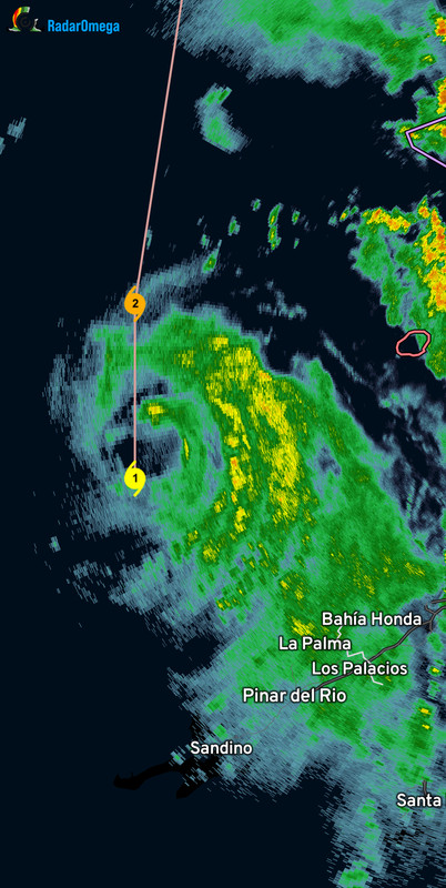
#1918 Postby TallyTracker » Tue Aug 29, 2023 8:29 am

sponger wrote:On the plus side, at least we have no other tropical systems do deal with, other than the chance of Idalia hooking around for another landfall. I am amazed at the complacency here in Saint Augustine. As if by saying it will be nothing will make it so. I have been preparing for over a week due to the strong probability of an active end to August. St Johns has not opened shelters and is in school today. At least Duval in Jacksonville closed for three days to play it safe. Lets hope we do not see another early hook. Apalachicola Bay is the best place it can land and I will be rooting on it to make it


Leon County only closed schools for tomorrow. After school activities are only canceled today after 6 pm. This could be the worst storm in Tallahassee history and people are left with little time to prepare or evacuate. Many people live in trailers in this area due to the rarity of strong storms. The Big Bend region is very unprepared for this caliber of storm. I’m praying that people will take this seriously and take shelter.
2 likes   
Fran '96, Georges '98, Gordon '00, Gabrielle '01, Charley '04, Frances '04, Jeanne '04, Barry '07, Fay '08, Debby '12, Matthew '16, Emily '17, Irma '17, Michael ‘18, Elsa ‘21, Fred ‘21, Mindy ‘21, Nicole ‘22, Idalia ‘23, Debby ‘24, Helene ‘24

User avatar
Iceresistance
Category 5
Category 5
Posts: 9288
Age: 21
Joined: Sat Oct 10, 2020 9:45 am
Location: Tecumseh, OK/Norman, OK

Re: ATL: IDALIA - Hurricane - Discussion

#1919 Postby Iceresistance » Tue Aug 29, 2023 8:32 am

Is it just me or is Idalia turning a little more to the west with the convection?

Image
https://s11.gifyu.com/images/Sg8Hl.gif
0 likes   
Bill 2015 & Beta 2020

Winter 2020-2021 :cold:

All observations are in Tecumseh, OK unless otherwise noted.

Winter posts are focused mainly for Oklahoma & Texas.

Take any of my forecasts with a grain of salt, refer to the NWS, SPC, and NHC for official information

Never say Never with weather! Because ANYTHING is possible!

User avatar
HurricaneEnzo
Category 2
Category 2
Posts: 739
Joined: Wed Mar 14, 2018 12:18 pm
Location: Newport, NC (Hurricane Alley)

Re: ATL: IDALIA - Hurricane - Discussion

#1920 Postby HurricaneEnzo » Tue Aug 29, 2023 8:33 am

Cleary wobbling back west a bit on radar. Overall motion in line with NHC forecast.
2 likes   
Bertha 96' - Fran 96' - Bonnie 98' - Dennis 99' - Floyd 99' - Isabel 03' - Alex 04' - Ophelia 05' - Irene 11' - Arthur 14' - Matthew 16' - Florence 18' - Dorian 19' - Isaias 20' (countless other tropical storms and Hurricane swipes)

I am not a Professional Met just an enthusiast. Get your weather forecasts from the Pros!


Return to “2023”

Who is online

Users browsing this forum: No registered users and 1 guest