 ....
....ATL: FRANKLIN - Post-Tropical - Discussion
Moderator: S2k Moderators
- Spacecoast
- Category 2

- Posts: 773
- Joined: Thu Aug 31, 2017 2:03 pm
Re: ATL: INVEST 90L - Discussion
Spacecoast wrote:06z SHIPS indicates TD is eminent
https://i.ibb.co/dMT5TkB/ef14.jpg ....
SHIPS automatically assumes that invests are TCs at initialization.
2 likes
-
Sciencerocks
- Category 5

- Posts: 10189
- Age: 40
- Joined: Thu Jul 06, 2017 1:51 am
- ElectricStorm
- Category 5

- Posts: 5152
- Age: 25
- Joined: Tue Aug 13, 2019 11:23 pm
- Location: Norman, OK
Re: ATL: INVEST 90L - Discussion
Surprised 7 day odds are still just at 40%. If it doesn't run right into Hispanola this could get a bit interesting
0 likes
B.S Meteorology, University of Oklahoma '25
Please refer to the NHC, NWS, or SPC for official information.
Please refer to the NHC, NWS, or SPC for official information.
Re: ATL: INVEST 90L - Discussion
ElectricStorm wrote:Surprised 7 day odds are still just at 40%. If it doesn't run right into Hispanola this could get a bit interesting
Nhc keeps shifting it west on the two
0 likes
- tropicwatch
- Category 5

- Posts: 3427
- Age: 62
- Joined: Sat Jun 02, 2007 10:01 am
- Location: The Villages, Florida
- Contact:
Re: ATL: INVEST 90L - Discussion
Ianswfl wrote:ElectricStorm wrote:Surprised 7 day odds are still just at 40%. If it doesn't run right into Hispanola this could get a bit interesting
Nhc keeps shifting it west on the two
I imagine they will increase the odds at the next outlook and will probably schedule a Hurricane Hunter for tomorrow if it keeps progressing as well as it has been this morning.
Last edited by tropicwatch on Sat Aug 19, 2023 12:36 pm, edited 1 time in total.
2 likes
Tropicwatch
Agnes 72', Eloise 75, Elena 85', Kate 85', Charley 86', Florence 88', Beryl 94', Dean 95', Erin 95', Opal 95', Earl 98', Georges 98', Ivan 2004', Arlene 2005', Dennis 2005', Ida 2009' Debby 2012' Irma 2017' Michael 2018'
Agnes 72', Eloise 75, Elena 85', Kate 85', Charley 86', Florence 88', Beryl 94', Dean 95', Erin 95', Opal 95', Earl 98', Georges 98', Ivan 2004', Arlene 2005', Dennis 2005', Ida 2009' Debby 2012' Irma 2017' Michael 2018'
- ouragans
- Category 2

- Posts: 501
- Age: 54
- Joined: Sun Jun 12, 2011 12:09 pm
- Location: Abymes, Guadeloupe F.W.I
- Contact:
Re: ATL: INVEST 90L - Discussion
I. ATLANTIC REQUIREMENTS
1. SUSPECT AREA (EASTERN CARIBBEAN - AL90)
FLIGHT ONE - NOAA 43
A. 20/1800Z
B. NOAA3 01BBA INVEST
C. 20/1630Z
D. 13.5N 66.0W
E. 20/1730Z TO 20/2230Z
F. SFC TO 10,000 FT
G. LOW-LEVEL INVEST
2. OUTLOOK FOR SUCCEEDING DAY:
A. ANOTHER POSSIBLE LOW-LEVEL INVEST MISSION INTO THE SUSPECT AREA AL90 NEAR 15.0N 69.0W FOR 21/1800Z.
B. NOAA 49 G-IV TDR MISSION AROUND SUSPECT AREA AL90 FOR 22/0600Z, DEPARTING KLAL AT 22/0300Z.
1 likes
Personal forecast disclaimer
This post is a personal point of view, not an information. Please refer to official statements for life-threatening decisions.
David '79, Frederic '79, Hugo '89, Iris, Luis & Marilyn '95, Georges '98, Lenny '99, Dean '07, Irma '17, Maria '17, Fiona '22, Philippe '23, Tammy '23
16°13'33.3,"6N -61°36'39.5"W
Re: ATL: INVEST 90L - Discussion
2 PM TWO excerpt:
A broad area of low pressure has formed near the Windward Islands,
shower and thunderstorm activity has become better organized since
yesterday. Some additional development of this system is likely and
a tropical depression could form by early next week while this
system moves westward to west-northwestward at 10 to 15 mph, across
the Lesser Antilles and over the eastern and central Caribbean Sea.
Regardless of development, heavy rainfall is possible over portions
of the Windward Islands during the next couple of days. Interests
in the eastern and central Caribbean should monitor the progress of
this system.
* Formation chance through 48 hours...medium...40 percent.
* Formation chance through 7 days...medium...60 percent.
0 likes
-
tolakram
- Admin

- Posts: 20186
- Age: 62
- Joined: Sun Aug 27, 2006 8:23 pm
- Location: Florence, KY (name is Mark)
Re: ATL: INVEST 90L - Discussion
0 likes
M a r k
- - - - -
Join us in chat: Storm2K Chatroom Invite. Android and IOS apps also available.
The posts in this forum are NOT official forecasts and should not be used as such. Posts are NOT endorsed by any professional institution or STORM2K.org. For official information and forecasts, please refer to NHC and NWS products.
-
tolakram
- Admin

- Posts: 20186
- Age: 62
- Joined: Sun Aug 27, 2006 8:23 pm
- Location: Florence, KY (name is Mark)
Re: ATL: INVEST 90L - Discussion

2 likes
M a r k
- - - - -
Join us in chat: Storm2K Chatroom Invite. Android and IOS apps also available.
The posts in this forum are NOT official forecasts and should not be used as such. Posts are NOT endorsed by any professional institution or STORM2K.org. For official information and forecasts, please refer to NHC and NWS products.
- - - - -
Join us in chat: Storm2K Chatroom Invite. Android and IOS apps also available.
The posts in this forum are NOT official forecasts and should not be used as such. Posts are NOT endorsed by any professional institution or STORM2K.org. For official information and forecasts, please refer to NHC and NWS products.
- gatorcane
- S2K Supporter

- Posts: 23708
- Age: 48
- Joined: Sun Mar 13, 2005 3:54 pm
- Location: Boca Raton, FL
Re: ATL: INVEST 90L - Discussion
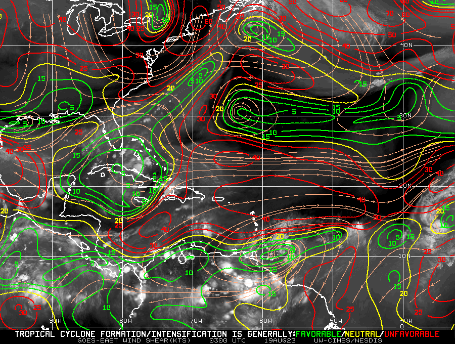
Shear is ripping across the Caribbean Sea. If it were not for that, we could have seen some significant organization prior to interacting with Hispaniola:


0 likes
Re: ATL: INVEST 90L - Discussion
gatorcane wrote:Shear is ripping across the Caribbean Sea. If it were not for that, we could have seen some significant organization prior to interacting with Hispaniola:
https://i.postimg.cc/CxfncTkX/wg8shr-4.gif
There looks to be an anti-cyclone near or over 90L currently. Can help to act as a buffer against that shear over the Caribbean.
0 likes
The posts or stuff said are NOT an official forecast. Please look to the NHC and NWS for official forecasts and products.
Floyd-1999, Frances-2004, Jeanne-2004, Fay-2008, Beryl-2012, Debby-2012, Colin-2016, Hermine-2016, Julia-2016, Matthew-2016, Irma-2017, Elsa-2021, Idalia-2023, Debby-2024, Helene-2024.
Go Gators! Go Jags!
Floyd-1999, Frances-2004, Jeanne-2004, Fay-2008, Beryl-2012, Debby-2012, Colin-2016, Hermine-2016, Julia-2016, Matthew-2016, Irma-2017, Elsa-2021, Idalia-2023, Debby-2024, Helene-2024.
Go Gators! Go Jags!
- cycloneye
- Admin

- Posts: 149686
- Age: 69
- Joined: Thu Oct 10, 2002 10:54 am
- Location: San Juan, Puerto Rico
Re: ATL: INVEST 90L - Discussion
AL, 90, 2023081918, , BEST, 0, 130N, 605W, 25, 1006, LO
0 likes
Visit the Caribbean-Central America Weather Thread where you can find at first post web cams,radars
and observations from Caribbean basin members Click Here
and observations from Caribbean basin members Click Here
- REDHurricane
- Category 1

- Posts: 438
- Age: 28
- Joined: Sun Jul 03, 2022 2:36 pm
- Location: Northeast Pacific Ocean
Re: ATL: INVEST 90L - Discussion
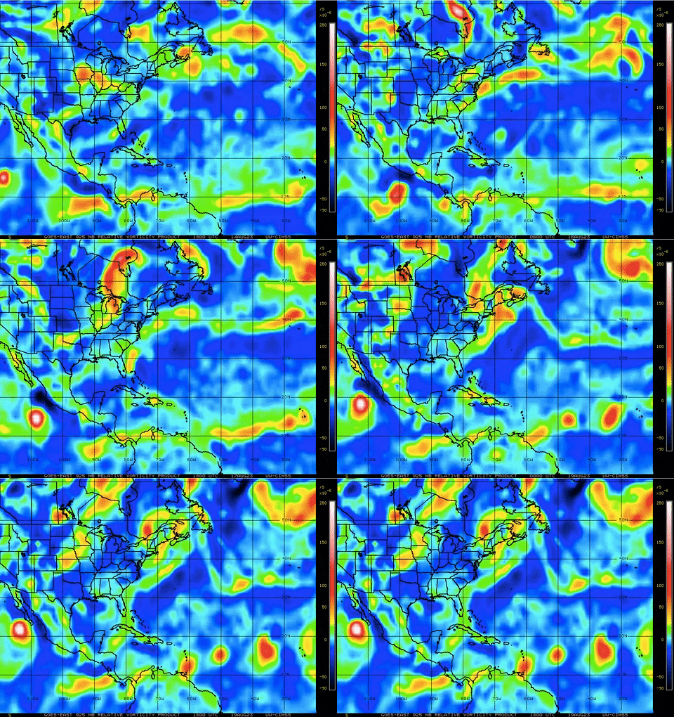
Low level vorticity has really been ramping for up for 90L in the past 6-12 hours, probably won't develop before 99L/TD6 but it'll be up next


1 likes
Re: ATL: INVEST 90L - Discussion
0 likes
-
Sciencerocks
- Category 5

- Posts: 10189
- Age: 40
- Joined: Thu Jul 06, 2017 1:51 am
- cycloneye
- Admin

- Posts: 149686
- Age: 69
- Joined: Thu Oct 10, 2002 10:54 am
- Location: San Juan, Puerto Rico
Re: ATL: INVEST 90L - Discussion
0 likes
Visit the Caribbean-Central America Weather Thread where you can find at first post web cams,radars
and observations from Caribbean basin members Click Here
and observations from Caribbean basin members Click Here
Who is online
Users browsing this forum: No registered users and 121 guests


