CPAC: CALVIN - Post-Tropical - Discussion

Moderator: S2k Moderators

Message
Author
User avatar
cycloneye
Admin
Admin
Posts: 139494
Age: 67
Joined: Thu Oct 10, 2002 10:54 am
Location: San Juan, Puerto Rico

Re: EPAC: CALVIN - Tropical Storm - Discussion

#201 Postby cycloneye » Sun Jul 16, 2023 3:44 pm

Tropical Storm Calvin Discussion Number 21
NWS National Hurricane Center Miami FL EP032023
1100 AM HST Sun Jul 16 2023

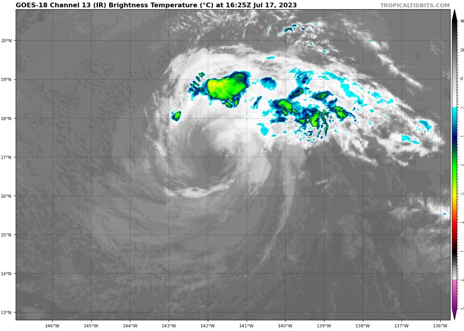
The satellite presentation of Calvin has not changed much since the
last advisory. Satellite images show a partially exposed low-level
circulation with a small area of moderate to deep convection near
the center. Satellite intensity estimates continue to fall, and a
blend of the latest Dvorak final-T and current intensity estimates
from TAFB and SAB support lowering the intensity to 55 kt.

Continued weakening is expected as Calvin moves over 24C SSTs and
into a drier, more stable environment during the next couple of
days. The cyclone could cease producing organized convection during
this time. Although environmental and oceanic conditions remain
marginal on its approach to Hawaii, there is still support in GFS,
ECMWF, and HAFS model-simulated satellite imagery for some new
bursts of convection as Calvin moves closer to the islands. So, the
NHC forecast keeps Calvin a tropical cyclone through 72 h, although
post-tropical status could occur sooner than forecast. Regardless,
the cyclone should still be producing some tropical-storm-force
winds in its northern semicircle upon its closest approach to
Hawaii, especially given the storm's fast forward motion.

There has been no change to the track forecast reasoning. A
mid-level ridge over the eastern Pacific is expected to steer Calvin
generally westward into the central Pacific basin late tonight or
early Monday and toward the Hawaiian Islands on Tuesday. The NHC
forecast shows the center of Calvin passing near or over the Big
Island of Hawaii early Wednesday, then continuing westward and
becoming post-tropical on Thursday before dissipating. The guidance
envelope has trended slightly southward this cycle, but little
change was required to the NHC forecast as it still lies near the
latest HFIP corrected consensus approach (HCCA) aid.

While the exact storm track near Hawaii is still uncertain, there is
potential for portions of the state to experience some heavy
rainfall, dangerous surf and rip current conditions, and minor wind
impacts from Calvin. A Tropical Storm Watch may be required for
portions of the main Hawaiian Islands later today.


KEY MESSAGES:

1. Calvin is forecast to approach the Hawaiian Islands during the
next couple of days or so, bringing the potential for heavy
rainfall and dangerous surf and rip current conditions. A Tropical
Storm Watch could be issued for portions of the main Hawaiian
Islands later today.


FORECAST POSITIONS AND MAX WINDS

INIT 16/2100Z 16.1N 136.3W 55 KT 65 MPH
12H 17/0600Z 16.5N 138.8W 45 KT 50 MPH
24H 17/1800Z 17.1N 142.3W 40 KT 45 MPH
36H 18/0600Z 17.5N 145.9W 40 KT 45 MPH
48H 18/1800Z 18.1N 149.7W 35 KT 40 MPH
60H 19/0600Z 18.7N 153.4W 35 KT 40 MPH
72H 19/1800Z 19.2N 157.0W 35 KT 40 MPH
96H 20/1800Z 20.0N 163.7W 30 KT 35 MPH...POST-TROP/REMNT LOW
120H 21/1800Z...DISSIPATED

$$
Forecaster Reinhart
0 likes   
Visit the Caribbean-Central America Weather Thread where you can find at first post web cams,radars
and observations from Caribbean basin members Click Here

Sciencerocks
Category 5
Category 5
Posts: 7294
Age: 38
Joined: Thu Jul 06, 2017 1:51 am

Re: EPAC: CALVIN - Tropical Storm - Discussion

#202 Postby Sciencerocks » Sun Jul 16, 2023 9:49 pm

Image
0 likes   

User avatar
cycloneye
Admin
Admin
Posts: 139494
Age: 67
Joined: Thu Oct 10, 2002 10:54 am
Location: San Juan, Puerto Rico

Re: EPAC: CALVIN - Tropical Storm - Discussion

#203 Postby cycloneye » Sun Jul 16, 2023 9:51 pm

Tropical Storm Calvin Discussion Number 22
NWS National Hurricane Center Miami FL EP032023
500 PM HST Sun Jul 16 2023

Calvin is slowly weakening, with diminishing deep convection mainly
over the eastern portion of the circulation. Convective banding
features have become ill-defined. The current intensity estimate
is reduced to 50 kt, based on a blend of subjective Dvorak
estimates from SAB and TAFB along with objective SATCON estimates
from UW-CIMSS.

Calvin is traversing SSTs of around 24 deg C, and although water
temperatures should increase slightly while the cyclone approaches
Hawaii, drier mid-level air as well as increasingly strong vertical
shear should cause gradual weakening over the next couple of days.
Nonetheless, the dynamical guidance, such as the HAFS and GFS
models, suggests that Calvin will still be producing winds near
tropical-storm-force, at least over its northern semicircle, when it
nears the Hawaiian Islands. The official intensity forecast is
similar to the previous one and is close to the model consensus.

The official track forecast and its reasoning are basically
unchanged from the previous advisory. A mid-level ridge to the
north of the tropical cyclone should maintain a generally westward
motion for the next few days. On this track, Calvin should
enter the central Pacific basin soon, and move near or over the
Big Island of Hawaii early Wednesday. It should then continue
westward, becoming post-tropical on Thursday before dissipating.
The official forecast remains close to the latest NOAA corrected
consensus guidance.

While the exact storm track near Hawaii is still uncertain, there is
potential for portions of the state to experience some heavy
rainfall, dangerous surf and rip current conditions, along with
minor wind impacts from Calvin. A Tropical Storm Watch may be
required for portions of the main Hawaiian Islands tonight.


KEY MESSAGES:

1. Calvin is forecast to approach the Hawaiian Islands during the
next couple of days or so, bringing the potential for heavy
rainfall and dangerous surf and rip current conditions. A Tropical
Storm Watch could be issued for portions of the main Hawaiian
Islands tonight.


FORECAST POSITIONS AND MAX WINDS

INIT 17/0300Z 16.4N 137.9W 50 KT 60 MPH
12H 17/1200Z 16.8N 140.4W 45 KT 50 MPH
24H 18/0000Z 17.3N 144.0W 40 KT 45 MPH
36H 18/1200Z 17.7N 147.7W 40 KT 45 MPH
48H 19/0000Z 18.3N 151.5W 35 KT 40 MPH
60H 19/1200Z 18.8N 155.0W 35 KT 40 MPH
72H 20/0000Z 19.4N 158.6W 30 KT 35 MPH
96H 21/0000Z 20.0N 165.0W 25 KT 30 MPH...POST-TROP/REMNT LOW
120H 22/0000Z...DISSIPATED

$$
Forecaster Pasch
0 likes   
Visit the Caribbean-Central America Weather Thread where you can find at first post web cams,radars
and observations from Caribbean basin members Click Here

User avatar
cycloneye
Admin
Admin
Posts: 139494
Age: 67
Joined: Thu Oct 10, 2002 10:54 am
Location: San Juan, Puerto Rico

Re: EPAC: CALVIN - Tropical Storm - Discussion

#204 Postby cycloneye » Mon Jul 17, 2023 3:37 am

Tropical Storm Calvin Discussion Number 23
NWS National Hurricane Center Miami FL EP032023
1100 PM HST Sun Jul 16 2023


Calvin continues to slowly weaken this evening, with warming cloud
tops and an asymmetric convective pattern, mainly on the eastern
portion of the system. Satellite imagery depicts that banding
features have also become less defined. Based on a blend of
subjective Dvorak estimates from SAB and TAFB, as well as ADT and
AiDT values from CIMMS, the intensity is lowered to 45 kt for this
advisory.

Calvin is currently moving over cool SSTs of around 24 degrees C,
and in a dry and stable environment. In about 24 hours, the ocean
temperatures will slightly increase as the system approaches Hawaii,
and many models suggest that Calvin will still be producing winds
near tropical-storm-force when it nears the Hawaiian Islands. As the
cyclone reaches the Hawaiian Islands, southerly vertical wind shear
will increase and GFS and ECMWF simulated satellite images show most
of the convection displaced on the northern side of the semi-circle.
The increased vertical wind shear and drier air will cause Calvin to
weaken after it passes the island chain and to dissipate by 96
hours. The intensity forecast lies near the model consensus and is
similar to the previous official NHC forecast.

A mid-level ridge to the north of Calvin should maintain a generally
westward motion for the next few days. On this track, Calvin will
be entering the central Pacific basin early tomorrow morning, and
move near or over the Big Island of Hawaii early Wednesday. It
should then continue westward until it dissipates. The official
forecast is near the previous NHC forecast and lies close to the
model consensus guidance.

This is the last forecast/advisory issued by the National Hurricane
Center on Calvin. Future information on this system can be found
in the forecast/advisories issued by the Central Pacific Hurricane
Center beginning at 1500 UTC.

KEY MESSAGES:

1. Calvin is forecast to approach the Hawaiian Islands during the
next couple of days, bringing the potential for heavy rainfall and
dangerous surf and rip currents. A Tropical Storm Watch could be
issued for portions of the main Hawaiian Islands on Monday.


FORECAST POSITIONS AND MAX WINDS

INIT 17/0900Z 16.7N 139.7W 45 KT 50 MPH
12H 17/1800Z 17.1N 142.3W 40 KT 45 MPH
24H 18/0600Z 17.4N 145.9W 40 KT 45 MPH
36H 18/1800Z 17.7N 149.6W 40 KT 45 MPH
48H 19/0600Z 18.2N 153.4W 35 KT 40 MPH
60H 19/1800Z 18.8N 156.9W 30 KT 35 MPH
72H 20/0600Z 19.5N 160.3W 25 KT 30 MPH
96H 21/0600Z...DISSIPATED

$$
Forecaster Kelly/Cangialosi
0 likes   
Visit the Caribbean-Central America Weather Thread where you can find at first post web cams,radars
and observations from Caribbean basin members Click Here

User avatar
cycloneye
Admin
Admin
Posts: 139494
Age: 67
Joined: Thu Oct 10, 2002 10:54 am
Location: San Juan, Puerto Rico

Re: CPAC: CALVIN - Tropical Storm - Discussion

#205 Postby cycloneye » Mon Jul 17, 2023 9:34 am

...TROPICAL STORM CALVIN ENTERS THE CENTRAL PACIFIC...
...TROPICAL STORM WATCH ISSUED FOR HAWAII COUNTY...


SUMMARY OF 500 AM HST...1500 UTC...INFORMATION
----------------------------------------------
LOCATION...16.8N 141.4W
ABOUT 920 MI...1480 KM E OF HILO HAWAII
ABOUT 1120 MI...1805 KM ESE OF HONOLULU HAWAII
MAXIMUM SUSTAINED WINDS...50 MPH...85 KM/H
PRESENT MOVEMENT...W OR 280 DEGREES AT 18 MPH...30 KM/H
MINIMUM CENTRAL PRESSURE...1000 MB...29.53 INCHES


Tropical Storm Calvin Discussion Number 24
NWS Central Pacific Hurricane Center Honolulu HI EP032023
500 AM HST Mon Jul 17 2023

Conventional infrared satellite imagery shows that Tropical
Storm Calvin's low-level circulation center (LLCC) appears to be
partially exposed early this morning. Therefore, the system has
crossed longitude 140W into the Central Pacific Hurricane Center
(CPHC's) area of responsibility. Scatterometer passes from last
evening showed a large swath of winds of 40-45 kt north of the
LLCC. The subjective Dvorak satellite classification from PHFO is
55 kt, SAB and JTWC are 35 kt, and TAFB's final fix is 45 kt. Based
on these observations, we are maintaining the current intensity at
45 kt for this advisory.

Calvin continues to move over cool SSTs of around 24 degrees C, and
in a dry and stable environment. In the next 18-24 hours, the SSTs
are expected to start gradually increasing as the cyclone begins to
move closer to the main Hawaiian Islands. Southerly vertical wind
shear will likely increase as Calvin nears the Big Island of
Hawaii. This shear combined with entertainment of drier air into
the system is expected to cause Calvin to weaken. This scenario
would likely result in most of the deep convection (assuming it
redevelops in the next day or two) being displaced to the north of
the LLCC. The intensity forecast lies near the model consensus,
and is similar to the previous official forecast we inherited from
the National Hurricane Center (NHC) in Miami, Florida. Note that
based on the recent scatterometer passes, we have expanded the
wind radii in the northern semicircle.

The mid-level ridge to the north of Calvin will likely maintain a
relatively rapid westward motion during the next few days. On this
track, Calvin will likely move near or over the Big Island of
Hawaii Tuesday night and Wednesday. It should then continue moving
westward until it dissipates. The official forecast is near the
previous NHC forecast, and lies close to the model consensus
guidance.

KEY MESSAGES:

1. Calvin is forecast to pass very close to the Big Island Tuesday
night and Wednesday, bringing a period of heavy rain, high surf and
locally strong winds. Calvin is expected to weaken as it moves
westward to the south of the other Hawaiian Islands Wednesday and
Wednesday night, bringing the potential for some peripheral impacts.


FORECAST POSITIONS AND MAX WINDS

INIT 17/1500Z 16.8N 141.4W 45 KT 50 MPH
12H 18/0000Z 17.1N 144.1W 40 KT 45 MPH
24H 18/1200Z 17.4N 147.7W 40 KT 45 MPH
36H 19/0000Z 17.8N 151.4W 40 KT 45 MPH
48H 19/1200Z 18.4N 155.1W 35 KT 40 MPH
60H 20/0000Z 19.0N 158.5W 30 KT 35 MPH
72H 20/1200Z 19.7N 162.0W 25 KT 30 MPH...POST-TROP/REMNT LOW
96H 21/1200Z...DISSIPATED

$$
Forecaster Houston
0 likes   
Visit the Caribbean-Central America Weather Thread where you can find at first post web cams,radars
and observations from Caribbean basin members Click Here

Sciencerocks
Category 5
Category 5
Posts: 7294
Age: 38
Joined: Thu Jul 06, 2017 1:51 am

Re: CPAC: CALVIN - Tropical Storm - Discussion

#206 Postby Sciencerocks » Mon Jul 17, 2023 10:28 am

Image
0 likes   

User avatar
Kingarabian
S2K Supporter
S2K Supporter
Posts: 15454
Joined: Sat Aug 08, 2009 3:06 am
Location: Honolulu, Hawaii

Re: CPAC: CALVIN - Tropical Storm - Discussion

#207 Postby Kingarabian » Mon Jul 17, 2023 10:29 am

Still a good a chance of intense rainfall from Calvin for all of the islands.
1 likes   
RIP Kobe Bryant

User avatar
wxman57
Moderator-Pro Met
Moderator-Pro Met
Posts: 22491
Age: 66
Joined: Sat Jun 21, 2003 8:06 pm
Location: Houston, TX (southwest)

Re: CPAC: CALVIN - Tropical Storm - Discussion

#208 Postby wxman57 » Mon Jul 17, 2023 11:43 am

I'm wondering what CPHC's definition of "partially exposed" means, referring to Calvin's center. Looks 100% exposed, to me. All squalls have just about dissipated. Impacts across the islands should be quite minimal. If it can hang onto a small area of showers/squalls, then it could produce a couple inches of rain in Hilo. No significant wind, though. It may well be a naked swirl with no convection as it passes the islands.

Image
5 likes   

Sciencerocks
Category 5
Category 5
Posts: 7294
Age: 38
Joined: Thu Jul 06, 2017 1:51 am

Re: CPAC: CALVIN - Tropical Storm - Discussion

#209 Postby Sciencerocks » Mon Jul 17, 2023 3:12 pm

Image
0 likes   

User avatar
cycloneye
Admin
Admin
Posts: 139494
Age: 67
Joined: Thu Oct 10, 2002 10:54 am
Location: San Juan, Puerto Rico

Re: CPAC: CALVIN - Tropical Storm - Discussion

#210 Postby cycloneye » Mon Jul 17, 2023 4:00 pm

Tropical Storm Calvin Discussion Number 25
NWS Central Pacific Hurricane Center Honolulu HI EP032023
1100 AM HST Mon Jul 17 2023

Satellite data showed an exposed low-level circulation center with
sparse deep convection only in the outer rainband well north
of the center. A US Air Force Reserve WC-130J flew its initial
mission into Calvin this morning. Based on a combination of
the flight level winds and dropsonde data, maximum winds appear
to be around 45 kt in the NE quad and will be used as the initial
intensity for this advisory. The SFMR data appeared to be too low.

There is little change in the steering environment. Calvin
continues to move westward to the south of a subtropical ridge. The
latest dynamical aids indicated that this steering will continue
over the next several days. There is still some spread in the
guidance for the track near the main Hawaiian Islands with HAFS-A
on the north end and CMC to the south. The track forecast is close
to the previous advisory, but with a slight increase in forward
speed. The forecast is also very close to HCCA. This puts the center
of Calvin near or over the Big Island on Wednesday, with tropical
storm force winds arriving Tuesday night.

The surrounding environment around Calvin has been dry and stable
with SSTs around 24-25C. As Calvin moves westward, the SSTs will
gradually increase, with values of 26-27C around the main Hawaiian
Islands. As a result, deep convection may become better developed,
which is suggested by model-simulated satellite imagery from some
of the dynamical models. This is expected to keep Calvin at
tropical storm intensity by the time it reaches the Big Island.
Calvin will also be affected by an upper tropospheric trough in
about 24-48 hrs. The trough will increase the vertical shear over
the tropical cyclone and result in its ultimate demise.


KEY MESSAGES:

1. Calvin is forecast to pass very close to the Big Island Tuesday
night and Wednesday, bringing a period of heavy rain, high surf and
locally strong winds. Calvin is expected to weaken as it moves
westward to the south of the other Hawaiian Islands Wednesday and
Wednesday night, bringing the potential for some peripheral impacts.

2. It is important to not focus on the exact forecast track and
intensity when preparing for Calvin. Persons in Hawaii County
should prepare for impacts today and Tuesday prior to the onset of
tropical storm force winds. These impacts could include flash
flooding, damaging winds, and large and dangerous surf.


FORECAST POSITIONS AND MAX WINDS

INIT 17/2100Z 17.3N 143.3W 45 KT 50 MPH
12H 18/0600Z 17.4N 146.2W 40 KT 45 MPH
24H 18/1800Z 17.9N 149.9W 40 KT 45 MPH
36H 19/0600Z 18.3N 153.7W 40 KT 45 MPH
48H 19/1800Z 19.0N 157.5W 35 KT 40 MPH
60H 20/0600Z 19.5N 161.2W 30 KT 35 MPH
72H 20/1800Z 20.0N 165.0W 25 KT 30 MPH...POST-TROP/REMNT LOW
96H 21/1800Z...DISSIPATED

$$
Forecaster Kodama
0 likes   
Visit the Caribbean-Central America Weather Thread where you can find at first post web cams,radars
and observations from Caribbean basin members Click Here

User avatar
Kingarabian
S2K Supporter
S2K Supporter
Posts: 15454
Joined: Sat Aug 08, 2009 3:06 am
Location: Honolulu, Hawaii

Re: CPAC: CALVIN - Tropical Storm - Discussion

#211 Postby Kingarabian » Mon Jul 17, 2023 4:35 pm

Surprised recon is out there.
0 likes   
RIP Kobe Bryant

Sciencerocks
Category 5
Category 5
Posts: 7294
Age: 38
Joined: Thu Jul 06, 2017 1:51 am

Re: CPAC: CALVIN - Tropical Storm - Discussion

#212 Postby Sciencerocks » Mon Jul 17, 2023 9:22 pm

Image
1 likes   

User avatar
cycloneye
Admin
Admin
Posts: 139494
Age: 67
Joined: Thu Oct 10, 2002 10:54 am
Location: San Juan, Puerto Rico

Re: CPAC: CALVIN - Tropical Storm - Discussion

#213 Postby cycloneye » Mon Jul 17, 2023 9:51 pm

Tropical Storm Calvin Discussion Number 26
NWS Central Pacific Hurricane Center Honolulu HI EP032023
500 PM HST Mon Jul 17 2023

Satellite data showed an exposed low-level circulation all day.
Although most of the deep convection today remained in the outer
circulation in the northern semicircle, recent images showed
some deep convection developing closer to the center. A US Air Force
Reserve WC-130J completed its recon mission this morning. The next
mission will be flown to support tonight's forecast packages.
Subjective Dvorak intensity estimates came in at 35 kt for PHFO and
JTWC. The latest CIMSS SATCON showed 43 kt. The initial intensity
for this advisory is 40 kt based on a blend of these estimates.

The initial motion for this advisory is 275/19 kt as Calvin moves
quickly westward to the south of a subtropical ridge. This speed is
a slight increase from the previous package. This steering is
expected to continue over the next several days. The dynamical
guidance indicates that the center of Calvin will pass over or just
south of the Big Island on Tuesday night. The track forecast is
close to the previous forecast, but is a bit faster. It is also
close to the HCCA guidance.

The surrounding environment around Calvin continues to be dry and
stable with SSTs around 24-25C. As Calvin moves westward, the SSTs
will gradually increase, with values of 26-27C around the main
Hawaiian Islands. The higher SSTs may result in deep convection
becoming better developed, which is suggested by model-simulated
satellite imagery from some of the dynamical models. This is should
keep Calvin at tropical storm intensity by the time it reaches the
Big Island. As a result, Hawaii County has been put in a Tropical
Storm Warning starting with this advisory. Calvin will also be
affected by an upper tropospheric trough in about 36-48 hrs. The
trough will increase the vertical shear over the tropical cyclone
and result post-tropical/remnant low status Wednesday night or more
likely Thursday.


KEY MESSAGES:

1. Calvin is forecast to pass over or very close to Hawaii County
Tuesday night, bringing a period of heavy rain, high surf and
locally strong winds. Calvin is expected to weaken as it moves
westward to the south of the other Hawaiian Islands Wednesday
and Wednesday night, bringing the potential for some peripheral
impacts.

2. It is important to not focus on the exact forecast track and
intensity when preparing for Calvin. Persons in Hawaii County
should prepare now through Tuesday for impacts prior to the onset of
tropical storm force winds. These impacts could include flash
flooding, damaging winds, and large and dangerous surf.


FORECAST POSITIONS AND MAX WINDS

INIT 18/0300Z 17.4N 145.4W 40 KT 45 MPH
12H 18/1200Z 17.7N 148.4W 40 KT 45 MPH
24H 19/0000Z 18.3N 152.3W 40 KT 45 MPH
36H 19/1200Z 18.9N 156.0W 35 KT 40 MPH
48H 20/0000Z 19.5N 159.8W 30 KT 35 MPH
60H 20/1200Z 19.9N 163.5W 25 KT 30 MPH
72H 21/0000Z 20.0N 167.0W 25 KT 30 MPH...POST-TROP/REMNT LOW
96H 22/0000Z...DISSIPATED

$$
Forecaster Kodama
0 likes   
Visit the Caribbean-Central America Weather Thread where you can find at first post web cams,radars
and observations from Caribbean basin members Click Here

User avatar
cycloneye
Admin
Admin
Posts: 139494
Age: 67
Joined: Thu Oct 10, 2002 10:54 am
Location: San Juan, Puerto Rico

Re: CPAC: CALVIN - Tropical Storm - Discussion

#214 Postby cycloneye » Tue Jul 18, 2023 4:52 am

Tropical Storm Calvin Discussion Number 27
NWS Central Pacific Hurricane Center Honolulu HI EP032023
1100 PM HST Mon Jul 17 2023

The most recent conventional infrared satellite imagery continues
to show the partially exposed low-level circulation center (LLCC)
of Tropical Storm Calvin. Deep convection has been developing
north of the LLCC during the past several hours. An aircraft
from the 53rd Weather Reconnaissance Squadron "Hurricane Hunters"
is currently sampling Tropical Storm Calvin as it continues to
move rapidly toward the Big Island of Hawaii late this evening.
Their flight-level data support tropical storm force winds with
this system. Recent satellite-based scatterometer passes also show
winds of at least 35 kt over a broad swath north and northeast of
the center. The most recent subjective Dvorak satellite intensity
estimates were 35 kt from PHFO and JTWC. The current CIMSS SATCON
estimate shows 41 kt. The initial intensity for this advisory is
maintained at 40 kt based on a blend of these estimates.

Calvin's initial motion for this advisory is 275/19 kt as the
cyclone continues to be steered rapidly westward south of a large
subtropical ridge. This steering is expected to continue over the
next 3 to 4 days. The dynamical guidance indicates that the center
of Calvin will pass over, or just south of the Big Island Tuesday
night. The latest track forecast is close to the previous
forecast, which continues to closely follow the HCCA guidance.

The surrounding environment around Calvin continues to be
relatively dry and stable. The SSTs are gradually increasing to
around 25C, and we expect additional warming of the SSTs to 26-27C
as it moves closer to the main Hawaiian Islands. The higher SSTs
may support additional deep convection spreading around the
northern semicircle of Calvin during the next day or two. This is
expected to keep the cyclone at tropical storm intensity by the
time it reaches the Big Island. As a result, a Tropical Storm
Warning remains in effect for Hawaii County. After it passes
southwest of the main Hawaiian Islands, we expect it to move near
an upper tropospheric trough in about 36-48 hrs. This feature aloft
will likely increase the vertical wind shear over the system, and
will eventually result in it becoming a post-tropical/remnant low
by Wednesday night or Thursday.


KEY MESSAGES:

1. Calvin is forecast to pass over or very close to Hawaii County
Tuesday night, bringing a period of heavy rain, high surf and
locally strong winds. Calvin is expected to weaken as it moves
westward to the south of the other Hawaiian Islands Wednesday
and Wednesday night, bringing the potential for some peripheral
impacts.

2. It is important to not focus on the exact forecast track and
intensity when preparing for Calvin. Persons in Hawaii County
should prepare from now through Tuesday afternoon for impacts
prior to the onset of tropical storm conditions. These impacts
could include flash flooding, damaging winds, and large and
dangerous surf.


FORECAST POSITIONS AND MAX WINDS

INIT 18/0900Z 17.4N 147.5W 40 KT 45 MPH
12H 18/1800Z 17.8N 150.4W 40 KT 45 MPH
24H 19/0600Z 18.5N 154.2W 35 KT 40 MPH
36H 19/1800Z 19.1N 158.0W 35 KT 40 MPH
48H 20/0600Z 19.6N 161.7W 30 KT 35 MPH
60H 20/1800Z 19.8N 165.3W 25 KT 30 MPH
72H 21/0600Z 20.1N 169.0W 20 KT 25 MPH...POST-TROP/REMNT LOW
96H 22/0600Z...DISSIPATED

$$
Forecaster Houston
0 likes   
Visit the Caribbean-Central America Weather Thread where you can find at first post web cams,radars
and observations from Caribbean basin members Click Here

User avatar
wxman57
Moderator-Pro Met
Moderator-Pro Met
Posts: 22491
Age: 66
Joined: Sat Jun 21, 2003 8:06 pm
Location: Houston, TX (southwest)

Re: CPAC: CALVIN - Tropical Storm - Discussion

#215 Postby wxman57 » Tue Jul 18, 2023 6:47 am

Looks like the plane did not find any TS wind in Calvin. Regardless, it won't be downgraded as it approaches the Big Island.
0 likes   

User avatar
NDG
S2K Supporter
S2K Supporter
Posts: 14934
Joined: Sun Jul 09, 2006 10:14 pm
Location: Orlando, FL

Re: CPAC: CALVIN - Tropical Storm - Discussion

#216 Postby NDG » Tue Jul 18, 2023 6:49 am

Hawaii has to thank the cooler than average waters to their east as this time the usual king TUTT is currently not present, otherwise Calvin would had Ben threatening them as a Hurricane.
0 likes   

User avatar
wxman57
Moderator-Pro Met
Moderator-Pro Met
Posts: 22491
Age: 66
Joined: Sat Jun 21, 2003 8:06 pm
Location: Houston, TX (southwest)

Re: CPAC: CALVIN - Tropical Storm - Discussion

#217 Postby wxman57 » Tue Jul 18, 2023 8:03 am

NDG wrote:Hawaii has to thank the cooler than average waters to their east as this time the usual king TUTT is currently not present, otherwise Calvin would had Ben threatening them as a Hurricane.


It is very hard for a hurricane to strike Hawaii from the east. Quite rare. Generally, hurricanes strike from the south where the environment is more favorable. Who is Ben? ;-)
2 likes   

Sciencerocks
Category 5
Category 5
Posts: 7294
Age: 38
Joined: Thu Jul 06, 2017 1:51 am

Re: CPAC: CALVIN - Tropical Storm - Discussion

#218 Postby Sciencerocks » Tue Jul 18, 2023 10:07 am

Image
1 likes   

User avatar
Yellow Evan
Professional-Met
Professional-Met
Posts: 15959
Age: 25
Joined: Fri Jul 15, 2011 12:48 pm
Location: Henderson, Nevada/Honolulu, HI
Contact:

Re: CPAC: CALVIN - Tropical Storm - Discussion

#219 Postby Yellow Evan » Tue Jul 18, 2023 10:41 am

After flirting with post-tropical status, convection has refired due to a favorable interaction with a TUTT improving upper level divergence and slightly better thermodynamic environment. Until this interacts with the high terrain of the island, which could greatly alter its trajectory in unexpected ways, I’d expect little change in strength.
1 likes   

User avatar
cycloneye
Admin
Admin
Posts: 139494
Age: 67
Joined: Thu Oct 10, 2002 10:54 am
Location: San Juan, Puerto Rico

Re: CPAC: CALVIN - Tropical Storm - Discussion

#220 Postby cycloneye » Tue Jul 18, 2023 11:07 am

Tropical Storm Calvin Discussion Number 28
NWS Central Pacific Hurricane Center Honolulu HI EP032023
500 AM HST Tue Jul 18 2023

A large area of thunderstorms continues to expand in coverage
near the partially exposed low-level circulation center (LLCC) of
Tropical Storm Calvin. An aircraft from the 53rd Weather
Reconnaissance Squadron "Hurricane Hunters" completed sampling
Calvin a few hours ago. They found winds at flight-level and from
dropwindsondes that suggested the peak surface wind speeds were
close to 40 kt. The most recent subjective Dvorak satellite
intensity estimates were 35 kt from PHFO and JTWC. The latest CIMSS
SATCON intensity estimate indicates 45 kt. The initial intensity
for this advisory is maintained at 40 kt based on a blend of these
estimates.

Calvin's initial motion for this advisory remains 275/19 kt as the
cyclone continues to be steered rapidly westward south of a large
subtropical ridge. This steering is expected to continue over the
next 3 to 4 days. The latest model guidance, including the HCCA,
indicates that the center of Calvin will pass over, or just south
of the Big Island tonight. The latest track forecast is close to
the previous forecast.

The surrounding environment around Calvin continues to be somewhat
dry and stable. The SSTs are gradually increasing to around 25C,
and we expect additional warming of the SSTs to 26-27C as it moves
closer to the main Hawaiian Islands. The higher SSTs will likely
support additional deep convection spreading around the northern
semicircle of Calvin at least into Wednesday. This is expected to
keep the cyclone at tropical storm intensity during the next 36
hours or so. As a result, a Tropical Storm Warning remains in
effect for Hawaii County. After it passes southwest of the main
Hawaiian Islands, we expect Calvin to move near an upper
tropospheric trough by day 2. This feature aloft will likely
increase the vertical wind shear over the system, and will
eventually result in it becoming a post-tropical/remnant low by
late Thursday. Finally, another "Hurricane Hunter" aircraft is
scheduled to fly a sampling mission into Calvin a few hours after
daybreak this morning. They will monitor any significant changes
in intensity and size as the system moves toward the Big Island.


KEY MESSAGES:

1. Calvin is forecast to pass over, or very close to Hawaii County
tonight, bringing a period of heavy rain, high surf and locally
strong winds. Calvin is expected to weaken as it moves westward to
the south of the other Hawaiian Islands Wednesday and Wednesday
night, bringing the potential for some peripheral impacts.

2. It is important to not focus on the exact forecast track and
intensity when preparing for Calvin. Persons in Hawaii County
should prepare during daylight hours for impacts prior to the
onset of tropical storm conditions, which are expected to start
this evening. These impacts could include flash flooding, damaging
winds, and large and dangerous surf.


FORECAST POSITIONS AND MAX WINDS

INIT 18/1500Z 17.5N 149.5W 40 KT 45 MPH
12H 19/0000Z 17.9N 152.4W 40 KT 45 MPH
24H 19/1200Z 18.6N 156.1W 35 KT 40 MPH
36H 20/0000Z 19.1N 159.9W 35 KT 40 MPH
48H 20/1200Z 19.5N 163.6W 30 KT 35 MPH
60H 21/0000Z 19.6N 167.4W 25 KT 30 MPH
72H 21/1200Z 20.0N 171.0W 20 KT 25 MPH...POST-TROP/REMNT LOW
96H 22/1200Z...DISSIPATED

$$
Forecaster Houston
0 likes   
Visit the Caribbean-Central America Weather Thread where you can find at first post web cams,radars
and observations from Caribbean basin members Click Here


Return to “2023”

Who is online

Users browsing this forum: No registered users and 7 guests