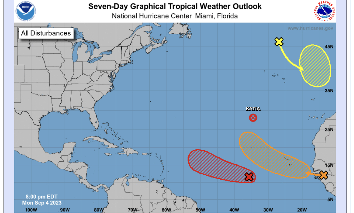
ATL: LEE - Post-Tropical - Discussion

Moderator: S2k Moderators

Message
Author
User avatar
aspen
Category 5
Category 5
Posts: 8812
Joined: Sat Oct 12, 2019 7:10 pm
Location: Connecticut, USA

Re: ATL: INVEST 95L - Discussion

#201 Postby aspen » Mon Sep 04, 2023 6:47 pm

cycloneye wrote:
Central Tropical Atlantic (AL95):
Showers and thunderstorms associated with an area of low pressure
located over the central tropical Atlantic about 800 miles
west-southwest of the Cabo Verde Islands have changed little in
organization through the day. However, environmental conditions
are conducive for further development, and a tropical depression or
tropical storm is expected to form over the next day or so while the
low moves toward the west-northwest at 15 to 20 mph across the
central tropical Atlantic. Additional strengthening, possibly to a
hurricane, is likely later this week while the system moves over
western portions of the tropical Atlantic, near or to the northeast
of the northern Leeward Islands. For additional information on
this system, including gale warnings, see High Seas Forecasts issued
by the National Weather Service.
* Formation chance through 48 hours...high...90 percent.
* Formation chance through 7 days...high...near 100 percent.

I’ve never seen them specify intensification into a hurricane in any TWO before.
6 likes   
Irene '11 Sandy '12 Hermine '16 5/15/2018 Derecho Fay '20 Isaias '20 Elsa '21 Henri '21 Ida '21

I am only a meteorology enthusiast who knows a decent amount about tropical cyclones. Look to the professional mets, the NHC, or your local weather office for the best information.

CrazyC83
Professional-Met
Professional-Met
Posts: 34001
Joined: Tue Mar 07, 2006 11:57 pm
Location: Deep South, for the first time!

Re: ATL: INVEST 95L - Discussion

#202 Postby CrazyC83 » Mon Sep 04, 2023 6:51 pm

I agree that there could be an M on the first cone, and maybe higher than 100 kt, although I suspect the NHC will be somewhat conservative at least initially. I think the EPAC has had some predicted to go to cat 4 on the first advisory though.

The best conditions look to be once it passes 50W. At that point, I see nothing to prevent it from becoming a cat 4 or 5. That will be in time for the first Recon flight too on Thursday evening.
5 likes   

User avatar
AnnularCane
S2K Supporter
S2K Supporter
Posts: 2836
Joined: Thu Jun 08, 2006 9:18 am
Location: Wytheville, VA

Re: ATL: INVEST 95L - Discussion

#203 Postby AnnularCane » Mon Sep 04, 2023 6:52 pm

Wow....have they EVER mentioned a hurricane in the TWO before? :eek:
0 likes   
"But it never rained rain. It never snowed snow. And it never blew just wind. It rained things like soup and juice. It snowed mashed potatoes and green peas. And sometimes the wind blew in storms of hamburgers." -- Judi Barrett, Cloudy with a Chance of Meatballs

User avatar
Blown Away
S2K Supporter
S2K Supporter
Posts: 10140
Joined: Wed May 26, 2004 6:17 am

Re: ATL: INVEST 95L - Discussion

#204 Postby Blown Away » Mon Sep 04, 2023 6:52 pm

Image

Luis, why did the NHC shrink the cone??
0 likes   
Hurricane Eye Experience: David 79, Irene 99, Frances 04, Jeanne 04, Wilma 05... EYE COMING MY WAY IN 2024…
Hurricane Brush Experience: Andrew 92, Erin 95, Floyd 99, Matthew 16, Irma 17, Ian 22, Nicole 22…

CrazyC83
Professional-Met
Professional-Met
Posts: 34001
Joined: Tue Mar 07, 2006 11:57 pm
Location: Deep South, for the first time!

Re: ATL: INVEST 95L - Discussion

#205 Postby CrazyC83 » Mon Sep 04, 2023 6:55 pm

AnnularCane wrote:Wow....have they EVER mentioned a hurricane in the TWO before? :eek:


I think the only times have been for storms with imminent landfall potential, such as Harvey and Ida.
4 likes   

User avatar
abajan
S2K Supporter
S2K Supporter
Posts: 4229
Joined: Sun Sep 07, 2003 5:10 am
Location: Barbados

Re: ATL: INVEST 95L - Discussion

#206 Postby abajan » Mon Sep 04, 2023 6:56 pm

Blown Away wrote:[url]https://i.postimg.cc/jjXjZK2h/273729-FB-7514-4-BA8-B581-C5-CE107808-AB.jpg [/url]

Luis, why did the NHC shrink the cone??

Because it's expected to develop into a tropical cyclone earlier than previously expected.
5 likes   

SconnieCane
Category 4
Category 4
Posts: 997
Joined: Thu Aug 02, 2018 5:29 pm
Location: Madison, WI

Re: ATL: INVEST 95L - Discussion

#207 Postby SconnieCane » Mon Sep 04, 2023 6:57 pm

Blown Away wrote:[url]https://i.postimg.cc/jjXjZK2h/273729-FB-7514-4-BA8-B581-C5-CE107808-AB.jpg [/url]

Luis, why did the NHC shrink the cone??


I think the shaded areas on the TWO are not really track cones (even though their shape and orientation does imply a general direction of motion for the area of interest)...just areas where genesis could occur. I think they shortened it because they're more confident that genesis will occur sooner, rather than close to or just NE of the Leeward Islands.

Edit: What he said. :uarrow:
Last edited by SconnieCane on Mon Sep 04, 2023 6:57 pm, edited 1 time in total.
5 likes   

User avatar
AnnularCane
S2K Supporter
S2K Supporter
Posts: 2836
Joined: Thu Jun 08, 2006 9:18 am
Location: Wytheville, VA

Re: ATL: INVEST 95L - Discussion

#208 Postby AnnularCane » Mon Sep 04, 2023 6:57 pm

Blown Away wrote:[url]https://i.postimg.cc/jjXjZK2h/273729-FB-7514-4-BA8-B581-C5-CE107808-AB.jpg [/url]

Luis, why did the NHC shrink the cone??


I don't think that's really a cone, just the area where development might take place.
3 likes   
"But it never rained rain. It never snowed snow. And it never blew just wind. It rained things like soup and juice. It snowed mashed potatoes and green peas. And sometimes the wind blew in storms of hamburgers." -- Judi Barrett, Cloudy with a Chance of Meatballs

User avatar
abajan
S2K Supporter
S2K Supporter
Posts: 4229
Joined: Sun Sep 07, 2003 5:10 am
Location: Barbados

Re: ATL: INVEST 95L - Discussion

#209 Postby abajan » Mon Sep 04, 2023 6:58 pm

AnnularCane wrote:Wow....have they EVER mentioned a hurricane in the TWO before? :eek:

Perhaps but not to the best of my recollection.
0 likes   

User avatar
cycloneye
Admin
Admin
Posts: 143871
Age: 68
Joined: Thu Oct 10, 2002 10:54 am
Location: San Juan, Puerto Rico

Re: ATL: INVEST 95L - Discussion

#210 Postby cycloneye » Mon Sep 04, 2023 7:00 pm

Blown Away wrote:[url]https://i.postimg.cc/jjXjZK2h/273729-FB-7514-4-BA8-B581-C5-CE107808-AB.jpg [/url]

Luis, why did the NHC shrink the cone??


That is because it will develop in the next 12-24 hours and that is why they trimmed it.
2 likes   
Visit the Caribbean-Central America Weather Thread where you can find at first post web cams,radars
and observations from Caribbean basin members Click Here

User avatar
Blown Away
S2K Supporter
S2K Supporter
Posts: 10140
Joined: Wed May 26, 2004 6:17 am

Re: ATL: INVEST 95L - Discussion

#211 Postby Blown Away » Mon Sep 04, 2023 7:03 pm

cycloneye wrote:
Blown Away wrote:[url]https://i.postimg.cc/jjXjZK2h/273729-FB-7514-4-BA8-B581-C5-CE107808-AB.jpg [/url]

Luis, why did the NHC shrink the cone??


That is because it will develop in the next 12-24 hours and that is why they trimmed it.


Ok, that makes sense cutting it from 7 to 5 days…
1 likes   
Hurricane Eye Experience: David 79, Irene 99, Frances 04, Jeanne 04, Wilma 05... EYE COMING MY WAY IN 2024…
Hurricane Brush Experience: Andrew 92, Erin 95, Floyd 99, Matthew 16, Irma 17, Ian 22, Nicole 22…

hipshot
Category 2
Category 2
Posts: 591
Joined: Tue Jul 06, 2010 9:18 pm
Location: Dallas, Texas

Re: ATL: INVEST 95L - Discussion

#212 Postby hipshot » Mon Sep 04, 2023 7:21 pm

abajan wrote:
Blown Away wrote:[url]https://i.postimg.cc/jjXjZK2h/273729-FB-7514-4-BA8-B581-C5-CE107808-AB.jpg [/url]

Luis, why did the NHC shrink the cone??

Because it's expected to develop into a tropical cyclone earlier than previously expected.

Thanks, I was going to ask the same question.
0 likes   

User avatar
msbee
S2K Supporter
S2K Supporter
Posts: 3027
Joined: Wed Jun 11, 2003 10:11 am
Location: St. Maarten

Re: ATL: INVEST 95L - Discussion

#213 Postby msbee » Mon Sep 04, 2023 7:33 pm

cycloneye wrote:
USVI-Kimmie-2 wrote:
cycloneye wrote:Believe me, I am watching from PR closely every motion 95L is doing as it will be important down the road. I am sure our friends in the Leewards and Virgin Islands are also watching.

Yeah, lots of us are... Too close for comfort :eek:


Tropical weather always are a changing thing and things change on a dime and we can't take for granted or as a stone a forecast or the models. My always all clear from a direct hit for the NE Caribbean islands is when a storm moves past the 20N latitude line.


You taught me about 20N years ago. I always use it now as an all clear too.
2 likes   
Too many hurricanes to remember

User avatar
TheDreamTraveler
Category 2
Category 2
Posts: 641
Joined: Sun Aug 22, 2010 3:10 am
Location: PA

Re: ATL: INVEST 95L - Models

#214 Postby TheDreamTraveler » Mon Sep 04, 2023 7:46 pm

I was going to write a comment about this earlier but it's been so long since we've had a scenario like this I doubted if it was even a feasible thing to take into account. Basically if 95L is forecast to be a monster powerful hurricane it's possible the hurricane itself can influence certain steering currents. Remember when a hurricane gets extremely deep it can potentially pump up the ridge which is something we've seen with previous intense hurricanes that went further west than model guidance suggested

 https://twitter.com/crownweather/status/1698821596620697809


Last edited by TheDreamTraveler on Mon Sep 04, 2023 7:48 pm, edited 2 times in total.
6 likes   

zzzh
Category 3
Category 3
Posts: 833
Joined: Thu Sep 02, 2021 1:13 pm

Re: ATL: INVEST 95L - Models

#215 Postby zzzh » Mon Sep 04, 2023 7:47 pm

Image
King ASCAT direct hit again, that's 6 in a row :lol: :lol: :lol:
Back to the topic, low level circulation is still broad, needs to tighten up.
7 likes   

User avatar
AtlanticWind
S2K Supporter
S2K Supporter
Posts: 1885
Age: 66
Joined: Sun Aug 08, 2004 9:57 pm
Location: Plantation,Fla

Re: ATL: INVEST 95L - Models

#216 Postby AtlanticWind » Mon Sep 04, 2023 8:01 pm

TheDreamTraveler wrote:I was going to write a comment about this earlier but it's been so long since we've had a scenario like this I doubted if it was even a feasible thing to take into account. Basically if 95L is forecast to be a monster powerful hurricane it's possible the hurricane itself can influence certain steering currents. Remember when a hurricane gets extremely deep it can potentially pump up the ridge which is something we've seen with previous intense hurricanes that went further west than model guidance suggested

https://twitter.com/crownweather/status/1698821596620697809


The infamous pump up the ridge talk begins.
I have heard this before and believe it is mostly
a falsehood that modeling doesn’t reflect the
influence of a powerful hurricane.

But I am not an expert so I can’t really say for sure.
3 likes   

User avatar
cycloneye
Admin
Admin
Posts: 143871
Age: 68
Joined: Thu Oct 10, 2002 10:54 am
Location: San Juan, Puerto Rico

Re: ATL: INVEST 95L - Discussion

#217 Postby cycloneye » Mon Sep 04, 2023 8:08 pm

AL, 95, 2023090500, , BEST, 0, 112N, 362W, 25, 1011, DB


Continues west.

Image
0 likes   
Visit the Caribbean-Central America Weather Thread where you can find at first post web cams,radars
and observations from Caribbean basin members Click Here

User avatar
cycloneye
Admin
Admin
Posts: 143871
Age: 68
Joined: Thu Oct 10, 2002 10:54 am
Location: San Juan, Puerto Rico

Re: ATL: INVEST 95L - Discussion

#218 Postby cycloneye » Mon Sep 04, 2023 8:11 pm

msbee wrote:
cycloneye wrote:
USVI-Kimmie-2 wrote:Yeah, lots of us are... Too close for comfort :eek:


Tropical weather always are a changing thing and things change on a dime and we can't take for granted or as a stone a forecast or the models. My always all clear from a direct hit for the NE Caribbean islands is when a storm moves past the 20N latitude line.


You taught me about 20N years ago. I always use it now as an all clear too.


Thanks Barbara. We are caribbean folks that like to help others in the islands in terms of the weather and especially, on hurricane season.
2 likes   
Visit the Caribbean-Central America Weather Thread where you can find at first post web cams,radars
and observations from Caribbean basin members Click Here

User avatar
weeniepatrol
Category 5
Category 5
Posts: 1252
Joined: Sat Aug 22, 2020 5:30 pm
Location: WA State

Re: ATL: INVEST 95L - Models

#219 Postby weeniepatrol » Mon Sep 04, 2023 8:12 pm

zzzh wrote:
King ASCAT direct hit again, that's 6 in a row :lol: :lol: :lol:


Must be a record
6 likes   

zzzh
Category 3
Category 3
Posts: 833
Joined: Thu Sep 02, 2021 1:13 pm

Re: ATL: INVEST 95L - Models

#220 Postby zzzh » Mon Sep 04, 2023 8:17 pm

zzzh wrote:https://i.imgur.com/g3qsrCu.jpg
King ASCAT direct hit again, that's 6 in a row :lol: :lol: :lol:
Back to the topic, low level circulation is still broad, needs to tighten up.

Wrong thread, can anyone move this post to discussion thread?
1 likes   


Return to “2023”

Who is online

Users browsing this forum: No registered users and 39 guests