ATL: IDALIA - Post-Tropical - Discussion
Moderator: S2k Moderators

Re: ATL: IDALIA - Hurricane - Discussion
I thought recon was supposed to head out at 2:30pm EST? It’s already almost 3:00pm EST.
0 likes
Irene '11 Sandy '12 Hermine '16 5/15/2018 Derecho Fay '20 Isaias '20 Elsa '21 Henri '21 Ida '21
I am only a meteorology enthusiast who knows a decent amount about tropical cyclones. Look to the professional mets, the NHC, or your local weather office for the best information.
I am only a meteorology enthusiast who knows a decent amount about tropical cyclones. Look to the professional mets, the NHC, or your local weather office for the best information.
-
MississippiWx

- S2K Supporter

- Posts: 1720
- Joined: Sat Aug 14, 2010 1:44 pm
- Location: Hattiesburg, Mississippi
Re: ATL: IDALIA - Hurricane - Discussion
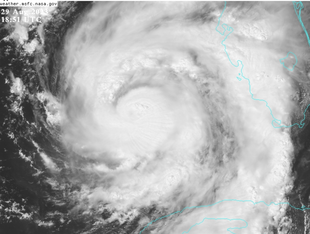
The striations forming in the CDO are beautiful. I believe there has been research in the past that shows this is a sign of significant strengthening.
Last edited by MississippiWx on Tue Aug 29, 2023 2:06 pm, edited 1 time in total.
3 likes
This post is not an official forecast and should not be used as such. It is just the opinion of MississippiWx and may or may not be backed by sound meteorological data. It is not endorsed by any professional institution including storm2k.org. For Official Information please refer to the NHC and NWS products.
-
Iceresistance

- Category 5

- Posts: 9565
- Age: 22
- Joined: Sat Oct 10, 2020 9:45 am
- Location: Tecumseh, OK/Norman, OK
Re: ATL: IDALIA - Hurricane - Discussion
aspen wrote:I thought recon was supposed to head out at 2:30pm EST? It’s already almost 3:00pm EST.
Saw a discord post about TEAL73

https://s11.gifyu.com/images/SgRTP.png
0 likes
Bill 2015 & Beta 2020
Winter 2020-2021
All observations are in Tecumseh, OK unless otherwise noted.
Winter posts are focused mainly for Oklahoma & Texas.
Take any of my forecasts with a grain of salt, refer to the NWS, SPC, and NHC for official information
Never say Never with weather! Because ANYTHING is possible!
Winter 2020-2021
All observations are in Tecumseh, OK unless otherwise noted.
Winter posts are focused mainly for Oklahoma & Texas.
Take any of my forecasts with a grain of salt, refer to the NWS, SPC, and NHC for official information
Never say Never with weather! Because ANYTHING is possible!
-
Hypercane_Kyle

- Category 5
- Posts: 3465
- Joined: Sat Mar 07, 2015 7:58 pm
- Location: Cape Canaveral, FL
Re: ATL: IDALIA - Hurricane - Discussion
Looks primed to go to me. I am going with 115 knots at landfall just north of Cedar Key.

4 likes
My posts are my own personal opinion, defer to the National Hurricane Center (NHC) and other NOAA products for decision making during hurricane season.
-
Poonwalker
- Category 1

- Posts: 270
- Joined: Tue Sep 20, 2022 11:12 am
Re: ATL: IDALIA - Hurricane - Discussion
psyclone wrote:Just enjoyed my first rainband in a pavilion at the top of tampa bay in Oldsmar. It was great. Water in the bay is high and coming up fast. Good luck to everyone up north
In the path of this beast
I have a townhouse in oldsmar right near McMullen booth and curlew. Looks like we are dodging another bullet.
1 likes


Re: ATL: IDALIA - Hurricane - Discussion
Camille was forecast repeatedly to change trajectory about 10 degrees to the right for two days before landfall. Never did. Of course, back then only one prog--the AVN. Euro, GFS, and HWRF all now take Idalia over TLH, best I can see on maps.
1 likes
List of 79 tropical cyclones intercepted by Richard Horodner:
http://www.canebeard.com/page/page/572246.htm
former storm2k screenname Beoumont 2009+
http://www.canebeard.com/page/page/572246.htm
former storm2k screenname Beoumont 2009+
-
TallyTracker
- Category 2

- Posts: 787
- Joined: Thu Oct 11, 2018 2:46 pm
Re: ATL: IDALIA - Hurricane - Discussion
Water levels are already 0.6 feet above normal at St. Marks.
https://water.weather.gov/ahps2/hydrograph.php?gage=mrkf1&wfo=tae
https://water.weather.gov/ahps2/hydrograph.php?gage=mrkf1&wfo=tae
1 likes
Fran '96, Georges '98, Gordon '00, Gabrielle '01, Charley '04, Frances '04, Jeanne '04, Barry '07, Fay '08, Debby '12, Matthew '16, Emily '17, Irma '17, Michael ‘18, Elsa ‘21, Fred ‘21, Mindy ‘21, Nicole ‘22, Idalia ‘23, Debby ‘24, Helene ‘24
-
jasons2k

- Storm2k Executive

- Posts: 8290
- Age: 52
- Joined: Wed Jul 06, 2005 12:32 pm
- Location: The Woodlands, TX
ATL: IDALIA - Hurricane - Discussion
This is shaping up to be a massive surge event. The story of Idalia will be about the surge when it’s over.
7 likes
-
Sciencerocks
- Category 5
- Posts: 10181
- Age: 40
- Joined: Thu Jul 06, 2017 1:51 am

-
ScottNAtlanta

- Category 5
- Posts: 2535
- Joined: Sat May 25, 2013 3:11 pm
- Location: Atlanta, GA
Re: ATL: IDALIA - Hurricane - Discussion
Iceresistance wrote:aspen wrote:I thought recon was supposed to head out at 2:30pm EST? It’s already almost 3:00pm EST.
Saw a discord post about TEAL73
https://s11.gifyu.com/images/SgRTP.png
https://s11.gifyu.com/images/SgRTP.png
Nothing is showing up on Google Earth currently
0 likes
The posts in this forum are NOT official forecast and should not be used as such. They are just the opinion of the poster and may or may not be backed by sound meteorological data. They are NOT endorsed by any professional institution or storm2k.org. For official information, please refer to the NHC and NWS products.
Re: ATL: IDALIA - Hurricane - Discussion
TallyTracker wrote:This is shaping up to be a devastating hit for my area. The power outages are going to be horrid due to trees. I fear the building codes are not up to this.
As far as I'm concerned, ALL of Florida should have the strict hurricane codes of S. FL.
These storms seem to be coming north just as strong as anything the south ever gets.
Maybe after this there will be changes to building codes in rural areas in the north.
In fact, maybe some areas did. Can anyone near Mexico Beach tell me? Did they update your building codes due to Michael's devastation?
3 likes
Cleo - 1964, Betsy - 1965, David - 1979, Andrew - 1992, Charlie (Francis, Ivan, Jeanne) - 2004, Irma - 2017, Ian - 2022, Milton - 2024
-
cheezyWXguy

- Category 5
- Posts: 6280
- Joined: Mon Feb 13, 2006 12:29 am
- Location: Dallas, TX
Re: ATL: IDALIA - Hurricane - Discussion
With the way Idalia is coming together it’s hard for me to believe this will be any less than a cat4. Comparing its current appearance to even 12 hours ago is dramatic.
3 likes
-
MississippiWx
- S2K Supporter
- Posts: 1720
- Joined: Sat Aug 14, 2010 1:44 pm
- Location: Hattiesburg, Mississippi
Re: ATL: IDALIA - Hurricane - Discussion
The eye is beginning to show itself in visible imagery. Hot towers are rotating quickly around it. Won't be long until she opens up.
1 likes
This post is not an official forecast and should not be used as such. It is just the opinion of MississippiWx and may or may not be backed by sound meteorological data. It is not endorsed by any professional institution including storm2k.org. For Official Information please refer to the NHC and NWS products.
-
cycloneye

- Admin
- Posts: 149137
- Age: 69
- Joined: Thu Oct 10, 2002 10:54 am
- Location: San Juan, Puerto Rico
Re: ATL: IDALIA - Hurricane - Discussion
1 likes
Visit the Caribbean-Central America Weather Thread where you can find at first post web cams,radars
and observations from Caribbean basin members Click Here
and observations from Caribbean basin members Click Here
-
Bostonriff

- Tropical Low

- Posts: 33
- Joined: Tue Sep 05, 2017 9:23 pm
Re: ATL: IDALIA - Hurricane - Discussion
What site is that imagery from? TIA.tolakram wrote:Tampa saved loop. Remember at this distance the radar is looking near the top of the eye. https://i.imgur.com/bnsvCI1.gif
0 likes
Do not bet the ranch based on any non-official forecasts that may appear in the post above no matter how strongly argued they may be, because the fates are capricious and have Murphy's Law on speed-dial.
-
Hypercane_Kyle
- Category 5
- Posts: 3465
- Joined: Sat Mar 07, 2015 7:58 pm
- Location: Cape Canaveral, FL
Re: ATL: IDALIA - Hurricane - Discussion

2 likes
My posts are my own personal opinion, defer to the National Hurricane Center (NHC) and other NOAA products for decision making during hurricane season.
Re: ATL: IDALIA - Hurricane - Discussion
Was just playing cards with the "girls."
They think it'll call be cleared out by tomorrow and they're going out to lunch!
I tried to tell them we're due to get all the "training" clouds coming in behind the storm through the middle of the state, some of them capable of producing tornadoes. They acted like *I'm* the one who doesn't know where the storm is.
4 likes
Cleo - 1964, Betsy - 1965, David - 1979, Andrew - 1992, Charlie (Francis, Ivan, Jeanne) - 2004, Irma - 2017, Ian - 2022, Milton - 2024
-
ElectricStorm

- Category 5
- Posts: 5125
- Age: 25
- Joined: Tue Aug 13, 2019 11:23 pm
- Location: Norman, OK
Re: ATL: IDALIA - Hurricane - Discussion
AF304 shows up on TT now about to take off
1 likes
B.S Meteorology, University of Oklahoma '25
Please refer to the NHC, NWS, or SPC for official information.
Please refer to the NHC, NWS, or SPC for official information.
-
USTropics
- Professional-Met

- Posts: 2736
- Joined: Sun Aug 12, 2007 3:45 am
- Location: Florida State University
Re: ATL: IDALIA - Hurricane - Discussion
MississippiWx wrote:The striations forming in the CDO are beautiful. I believe there has been research in the past that shows this is a sign of significant strengthening.
https://i.postimg.cc/26NB6VYH/Screenshot-2023-08-29-at-1-54-46-PM.png
Indeed, it's related to the intense convection and strong updrafts that have occurred over the past several hours. When there is a sudden rush of warm, moist air in the core of the system, it can create vertical perturbations that propagate upwards as gravity waves. This causes those striation patterns in the CDO.
2 likes
-
cycloneye
- Admin
- Posts: 149137
- Age: 69
- Joined: Thu Oct 10, 2002 10:54 am
- Location: San Juan, Puerto Rico
Re: ATL: IDALIA - Hurricane - Discussion
Here we go!!. Air Force plane is taxing to then depart.

4 likes
Visit the Caribbean-Central America Weather Thread where you can find at first post web cams,radars
and observations from Caribbean basin members Click Here
and observations from Caribbean basin members Click Here
Who is online
Users browsing this forum: No registered users and 10 guests