https://twitter.com/DerekOrtt/status/1681365986904264704
CPAC: CALVIN - Post-Tropical - Discussion
Moderator: S2k Moderators
-
cycloneye

- Admin

- Posts: 149710
- Age: 69
- Joined: Thu Oct 10, 2002 10:54 am
- Location: San Juan, Puerto Rico
Re: CPAC: CALVIN - Tropical Storm - Discussion
2 likes
Visit the Caribbean-Central America Weather Thread where you can find at first post web cams,radars
and observations from Caribbean basin members Click Here
and observations from Caribbean basin members Click Here
-
cycloneye
- Admin
- Posts: 149710
- Age: 69
- Joined: Thu Oct 10, 2002 10:54 am
- Location: San Juan, Puerto Rico
Re: CPAC: CALVIN - Tropical Storm - Discussion
Kingarabian Up to 45kt.
EP, 03, 2023071818, , BEST, 0, 176N, 1505W, 45, 1002, TS
0 likes
Visit the Caribbean-Central America Weather Thread where you can find at first post web cams,radars
and observations from Caribbean basin members Click Here
and observations from Caribbean basin members Click Here
-
Sciencerocks
- Category 5

- Posts: 10193
- Age: 40
- Joined: Thu Jul 06, 2017 1:51 am

-
Kingarabian

- S2K Supporter

- Posts: 16379
- Joined: Sat Aug 08, 2009 3:06 am
- Location: Honolulu, Hawaii
Re: CPAC: CALVIN - Tropical Storm - Discussion
cycloneye wrote: Kingarabian Up to 45kt.EP, 03, 2023071818, , BEST, 0, 176N, 1505W, 45, 1002, TS
Could get a little higher before it reaches shore. Looks like Puna side will get affected more than thought if those winds actually reach the surface.
2 likes
-
arizona_sooner
- Tropical Depression

- Posts: 64
- Joined: Sat Jan 09, 2010 10:09 am
- Location: Peoria, AZ
Re: CPAC: CALVIN - Tropical Storm - Discussion
Well I am on the west side of the big island now. It is sunny and quite windy this morning. I anticipate conditions will stay windy throughout today but I am skeptical of any heavy rain here since the wind direction will be downslope pretty much all day.
1 likes
-
HurricaneEnzo

- Category 2

- Posts: 744
- Joined: Wed Mar 14, 2018 12:18 pm
- Location: Newport, NC (Hurricane Alley)
Re: CPAC: CALVIN - Tropical Storm - Discussion
Calvin is definitely no looker but still rare to see a tropical system getting even a little better organized as it approaches Hawaii from the East. Usually, they are fading on approach.
1 likes
Bertha 96' - Fran 96' - Bonnie 98' - Dennis 99' - Floyd 99' - Isabel 03' - Alex 04' - Ophelia 05' - Irene 11' - Arthur 14' - Matthew 16' - Florence 18' - Dorian 19' - Isaias 20' (countless other tropical storms and Hurricane swipes)
I am not a Professional Met just an enthusiast. Get your weather forecasts from the Pros!
I am not a Professional Met just an enthusiast. Get your weather forecasts from the Pros!
-
Yellow Evan

- Professional-Met

- Posts: 16257
- Age: 27
- Joined: Fri Jul 15, 2011 12:48 pm
- Location: Henderson, Nevada/Honolulu, HI
- Contact:
Re: CPAC: CALVIN - Tropical Storm - Discussion

Divergent UL environment likely aiding in the persistence of convection.
2 likes
-
cycloneye
- Admin
- Posts: 149710
- Age: 69
- Joined: Thu Oct 10, 2002 10:54 am
- Location: San Juan, Puerto Rico
Re: CPAC: CALVIN - Tropical Storm - Discussion
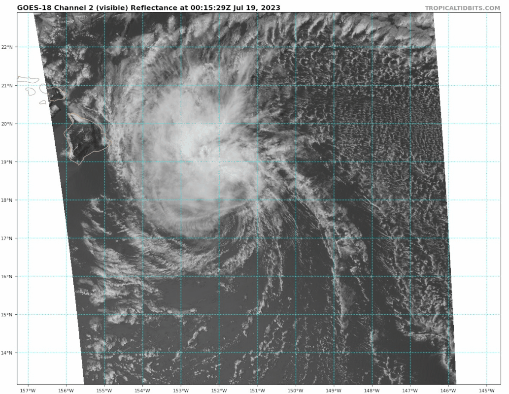
Tropical Storm Calvin Discussion Number 29
NWS Central Pacific Hurricane Center Honolulu HI EP032023
1100 AM HST Tue Jul 18 2023
A large area of deep convection developed overnight in the northern
semicircle of Calvin's circulation. This convection has persisted
through this morning and has obscured the low level circulation
center that was so clearly visible yesterday. Fortunately, the US
Air Force Reserve has a WC-130J flying a mission into the system
today that has helped better identify the system's center and
surrounding wind field. SFMR data indicated 46 kt in the NE
quadrant and a large area of winds at or above 34 kt. As a result,
the initial intensity for this advisory has been increased slightly
to 45 kt. The 34 kt radius in the NE quadrant has also been
increased as well.
The initial motion for this advisory is 280/19 kt as Calvin
continues to move south of a subtropical ridge. No significant
changes in this steering is expected over the next several days.
The main objective aids have the center of Calvin passing south of
the Big Island tonight. The track forecast is essentially the same
as the previous advisory and is on the northern side of the
guidance envelope, but still south of the Big Island.
The overall environment around Calvin remains dry and stable. Calvin
is currently passing over SSTs of 25-26C. Along the forecast track,
SSTs will be gradually increasing and will be 26-27C as Calvin
passes the Big Island. Vertical shear affecting the tropical cyclone
is expected to be moderate through tonight. The lack of strong
vertical shear, and the warmer SSTs should allow Calvin to maintain
winds at tropical storm intensities through Wednesday. Shear levels
should significantly increase Wednesday night onward, and should
result in a weakening to post-tropical/remnant low status on
Thursday.
KEY MESSAGES:
1. Calvin is forecast to pass very close to Hawaii County tonight,
bringing a period of heavy rain, high surf and locally strong winds.
Calvin is expected to weaken as it moves westward to the south of
the other Hawaiian Islands Wednesday and Wednesday night, bringing
the potential for some peripheral impacts.
2. It is important to not focus on the exact forecast track and
intensity when preparing for Calvin. Persons in Hawaii County
should prepare during daylight hours for impacts prior to the
onset of tropical storm conditions, which are expected to start
this evening. These impacts could include flash flooding, damaging
winds, and large and dangerous surf.
FORECAST POSITIONS AND MAX WINDS
INIT 18/2100Z 17.8N 151.9W 45 KT 50 MPH
12H 19/0600Z 18.2N 154.3W 45 KT 50 MPH
24H 19/1800Z 18.8N 158.1W 40 KT 45 MPH
36H 20/0600Z 19.2N 161.8W 35 KT 40 MPH
48H 20/1800Z 19.5N 165.6W 30 KT 35 MPH
60H 21/0600Z 19.8N 169.3W 25 KT 30 MPH...POST-TROP/REMNT LOW
72H 21/1800Z...DISSIPATED
$$
Forecaster Kodama
0 likes
Visit the Caribbean-Central America Weather Thread where you can find at first post web cams,radars
and observations from Caribbean basin members Click Here
and observations from Caribbean basin members Click Here
-
Kingarabian
- S2K Supporter
- Posts: 16379
- Joined: Sat Aug 08, 2009 3:06 am
- Location: Honolulu, Hawaii
Re: CPAC: CALVIN - Tropical Storm - Discussion
Convection covering most of the LLC now.
0 likes
RIP Kobe Bryant

-
wxman57

- Moderator-Pro Met

- Posts: 23175
- Age: 68
- Joined: Sat Jun 21, 2003 8:06 pm
- Location: Houston, TX (southwest)
Re: CPAC: CALVIN - Tropical Storm - Discussion
What a difference a few hours can make. After flaring up with winds getting in the 45-50 kt range 4-5 hours ago, convection has nearly dissipated in the last 2 hrs. Just "poof"! I can see what looks like a mid-level circulation near 19.1N/152.2W and an LLC down near 17.8N/152.1W. Could Calvin have completely decoupled?

2 likes

Re: CPAC: CALVIN - Tropical Storm - Discussion
wxman57 wrote:What a difference a few hours can make. After flaring up with winds getting in the 45-50 kt range 4-5 hours ago, convection has nearly dissipated in the last 2 hrs. Just "poof"! I can see what looks like a mid-level circulation near 19.1N/152.2W and an LLC down near 17.8N/152.1W. Could Calvin have completely decoupled?
http://wxman57.com/images/Calvin2.JPG
Calvin's MSWs have actually continued to increase and, according to the latest advisory, are now 60 mph.
0 likes
-
USTropics
- Professional-Met
- Posts: 2739
- Joined: Sun Aug 12, 2007 3:45 am
- Location: Florida State University
Re: CPAC: CALVIN - Tropical Storm - Discussion
Was a fun system to track. Definitely looks like the circulation collapsed, clear signs of an outflow boundary with the arch-shaped cloud structures rushing away from the center in the meso loops:
HMON forecast looking pretty good, with the LLC shooting westward south of the big island and the MLC racing NW before dissipating:

HMON forecast looking pretty good, with the LLC shooting westward south of the big island and the MLC racing NW before dissipating:
3 likes
-
wxman57
- Moderator-Pro Met
- Posts: 23175
- Age: 68
- Joined: Sat Jun 21, 2003 8:06 pm
- Location: Houston, TX (southwest)
Re: CPAC: CALVIN - Tropical Storm - Discussion
abajan wrote:wxman57 wrote:What a difference a few hours can make. After flaring up with winds getting in the 45-50 kt range 4-5 hours ago, convection has nearly dissipated in the last 2 hrs. Just "poof"! I can see what looks like a mid-level circulation near 19.1N/152.2W and an LLC down near 17.8N/152.1W. Could Calvin have completely decoupled?
http://wxman57.com/images/Calvin2.JPG
Calvin's MSWs have actually continued to increase and, according to the latest advisory, are now 60 mph.
That advisory was written prior to the collapse of the convection.
1 likes
-
cycloneye
- Admin
- Posts: 149710
- Age: 69
- Joined: Thu Oct 10, 2002 10:54 am
- Location: San Juan, Puerto Rico
Re: CPAC: CALVIN - Tropical Storm - Discussion
BULLETIN
Tropical Storm Calvin Advisory Number 30
NWS Central Pacific Hurricane Center Honolulu HI EP032023
500 PM HST Tue Jul 18 2023
...TROPICAL STORM CALVIN APPROACHING THE BIG ISLAND...
...IMPACTS IN HAWAII COUNTY STARTING THIS EVENING...
SUMMARY OF 500 PM HST...0300 UTC...INFORMATION
----------------------------------------------
LOCATION...17.8N 153.3W
ABOUT 175 MI...285 KM SE OF HILO HAWAII
ABOUT 385 MI...620 KM SE OF HONOLULU HAWAII
MAXIMUM SUSTAINED WINDS...60 MPH...95 KM/H
PRESENT MOVEMENT...W OR 275 DEGREES AT 21 MPH...33 KM/H
MINIMUM CENTRAL PRESSURE...1003 MB...29.62 INCHES
Tropical Storm Calvin Discussion Number 30
NWS Central Pacific Hurricane Center Honolulu HI EP032023
500 PM HST Tue Jul 18 2023
A burst of deep convection north of the center today strengthened
Calvin, and a couple of passes through the circulation by
the US Air Force Reserve's Hurricane Hunters showed an increase in
the winds. SFMR showed some peaks at around 55 kt, though these may
have had some rain contamination. The on-board weather officer
indicated 48-50 kt may be more reasonable. Reduction of flight level
winds showed 45-50 kt in portions of the northern semicircle. Based
on these data, the initial intensity for this advisory has been
increased to 50 kt. The aircraft data also resulted in an increase
in the 34 kt wind radii. The recent strengthening may have been a
short term trend as the deep convection has eased since this morning
with cloud top temperatures warming through the afternoon.
The initial motion for this advisory is 275/18 kt as Calvin
continues to move south of a large subtropical ridge. No significant
changes in this steering is expected over the next several days.
The main objective aids have the center of Calvin passing south of
the Big Island tonight. The forecast for this advisory is
essentially on the previous forecast track but slightly slower as a
reflection of the slower initial motion. The forecast track also
remains on the northern side of the guidance envelope. Although the
center of Calvin is expected to pass south of the Big Island, most
of the island is well within the 34 kt radius, and impacts from
strong winds, heavy rainfall, and high surf are expected.
Although Calvin strengthened today, the dynamical models suggest
that this was a short term change and the forecast still calls for
Calvin to pass south of the Big Island as a weakening tropical
storm. Vertical shear affecting the tropical cyclone is expected to
be moderate through tonight and into Wednesday, then will quickly
become strong by Wednesday night. The strong shear should result in
a weakening to post-tropical/remnant low status on Thursday.
KEY MESSAGES:
1. Calvin is forecast to pass south of Hawaii County tonight,
bringing a period of flash flooding, dangerous surf and damaging
winds. Calvin is expected to weaken as it moves westward to the
south of the other Hawaiian Islands Wednesday and Wednesday night,
bringing the potential for some peripheral impacts.
FORECAST POSITIONS AND MAX WINDS
INIT 19/0300Z 17.8N 153.3W 50 KT 60 MPH
12H 19/1200Z 18.4N 156.0W 45 KT 50 MPH
24H 20/0000Z 18.9N 159.8W 40 KT 45 MPH
36H 20/1200Z 19.4N 163.6W 35 KT 40 MPH
48H 21/0000Z 19.7N 167.5W 30 KT 35 MPH
60H 21/1200Z 19.9N 171.2W 30 KT 35 MPH...POST-TROP/REMNT LOW
72H 22/0000Z...DISSIPATED
$$
Forecaster Kodama
0 likes
Visit the Caribbean-Central America Weather Thread where you can find at first post web cams,radars
and observations from Caribbean basin members Click Here
and observations from Caribbean basin members Click Here
-
Sciencerocks
- Category 5
- Posts: 10193
- Age: 40
- Joined: Thu Jul 06, 2017 1:51 am

-
arizona_sooner
- Tropical Depression
- Posts: 64
- Joined: Sat Jan 09, 2010 10:09 am
- Location: Peoria, AZ
Re: CPAC: CALVIN - Tropical Storm - Discussion
Well on the west side of the big island, we had a mostly sunny warm day. The wind laid down after being quite strong this morning.
But currently, the wind is picking back up a little and clouds are moving in. Mauna Kea, visible this morning, is back to being completely obscured.
But currently, the wind is picking back up a little and clouds are moving in. Mauna Kea, visible this morning, is back to being completely obscured.
0 likes
-
somethingfunny

- ChatStaff

- Posts: 3926
- Age: 37
- Joined: Thu May 31, 2007 10:30 pm
- Location: McKinney, Texas
Re: CPAC: CALVIN - Tropical Storm - Discussion
0 likes
I am not a meteorologist, and any posts made by me are not official forecasts or to be interpreted as being intelligent. These posts are just my opinions and are probably silly opinions.
-
cycloneye
- Admin
- Posts: 149710
- Age: 69
- Joined: Thu Oct 10, 2002 10:54 am
- Location: San Juan, Puerto Rico
Re: CPAC: CALVIN - Tropical Storm - Discussion
Tropical Storm Calvin Discussion Number 31
NWS Central Pacific Hurricane Center Honolulu HI EP032023
1100 PM HST Tue Jul 18 2023
Deep convection has decreased considerably near the center of
Calvin since late this afternoon, but has begun to increase farther
to the north along windward shores and slopes of the Big Island of
Hawaii. The low level circulation center (LLCC) is rapidly becoming
unveiled again. Instruments aboard the US Air Force Reserve's
Hurricane Hunter aircraft showed maximum flight level winds of 50
kt, reduced to about 45 kt at the surface. Objective Dvorak
satellite analyses from PHFO and JTWC gave current intensity
numbers of 2.5 or 35 kt. Based on these data, the initial intensity
for this advisory has been decreased to 45 kt.
The initial motion for this advisory is 275/17 kt as Calvin
continues to move south of a large subtropical ridge. No significant
change in this steering is expected over the next several days.
After passing south of the Big Island tonight, the forecast is
essentially the same as the previous forecast track but slightly
to the south to account for a small adjustment in initial position,
thanks to the newly revealed LLCC. The forecast track lies within,
but on the southern side, of the guidance envelope due to the
initial point adjustment. Although the center of Calvin is passing
south of the Big Island, most of the island is well within the 34
kt radius, and impacts from strong winds, heavy rainfall, and high
surf are imminent or occurring.
The forecast calls for Calvin to pass south of the Big Island, then
southwest of the rest of the main island chain, as a weakening
tropical storm. Vertical shear affecting the tropical cyclone is
expected to be moderate through tonight and into Wednesday, then
strong by Wednesday night. The strong shear should result in a
weakening to post-tropical/remnant low status on Friday.
KEY MESSAGES:
1. Calvin has begun to pass south of Hawaii County. Expect periods
of flash flooding, dangerous surf and damaging winds. Calvin will
weaken as it moves westward to the south of the other Hawaiian
Islands Wednesday and Wednesday night, bringing the potential for
some peripheral impacts.
FORECAST POSITIONS AND MAX WINDS
INIT 19/0900Z 17.7N 155.2W 45 KT 50 MPH
12H 19/1800Z 17.8N 158.1W 45 KT 50 MPH
24H 20/0600Z 18.1N 161.9W 40 KT 45 MPH
36H 20/1800Z 18.3N 165.8W 35 KT 40 MPH
48H 21/0600Z 18.3N 169.7W 30 KT 35 MPH
60H 21/1800Z 18.0N 173.4W 30 KT 35 MPH...POST-TROP/REMNT LOW
72H 22/0600Z...DISSIPATED
$$
Forecaster Powell
0 likes
Visit the Caribbean-Central America Weather Thread where you can find at first post web cams,radars
and observations from Caribbean basin members Click Here
and observations from Caribbean basin members Click Here
-
wxman57
- Moderator-Pro Met
- Posts: 23175
- Age: 68
- Joined: Sat Jun 21, 2003 8:06 pm
- Location: Houston, TX (southwest)
Re: CPAC: CALVIN - Tropical Storm - Discussion
Interesting that CPHC only uses the FL wind from reconnaissance and not SFMR data. They drop the near 50kt FL wind to the surface to get a wind of 45 kts, but SFMR indicates less than 35 kts (peak value 28 kts) and a pressure of 1008mb. It is improper to reduce FL winds down to the surface using standard factors when there is no significant convection and not in the eyewall. Hilo reported a max sustained wind of 14 kts with a peak gust to 20 kts over the past 6 hours.
Correction: Latest recon pass indicates a wave axis. No closed circulation.
Correction: Latest recon pass indicates a wave axis. No closed circulation.
4 likes
Who is online
Users browsing this forum: No registered users and 61 guests