EPAC: HILARY - Post-Tropical - Discussion

Moderator: S2k Moderators

Message
Author
BobHarlem
Category 5
Category 5
Posts: 2102
Joined: Thu Oct 20, 2005 6:11 pm

Re: EPAC: HILARY - Hurricane - Discussion: Plane flying from Keesler base

#221 Postby BobHarlem » Fri Aug 18, 2023 8:34 am

12z early models.

TVCN shows landfall just north of Carlsbad, near Camp Pendleton,


Image
0 likes   

User avatar
aspen
Category 5
Category 5
Posts: 8818
Joined: Sat Oct 12, 2019 7:10 pm
Location: Connecticut, USA

Re: EPAC: HILARY - Hurricane - Discussion: Plane flying from Keesler base

#222 Postby aspen » Fri Aug 18, 2023 8:49 am

I’m thinking recon will find a low-end 4 or a high-end 3 when it finally arrives. There’s very clearly an EWRC (and/or maybe some upwelling) impacting Hilary’s satellite presentation. It has maybe 18 hours maximum before SSTs/MPI start rapidly dropping.
1 likes   
Irene '11 Sandy '12 Hermine '16 5/15/2018 Derecho Fay '20 Isaias '20 Elsa '21 Henri '21 Ida '21

I am only a meteorology enthusiast who knows a decent amount about tropical cyclones. Look to the professional mets, the NHC, or your local weather office for the best information.

User avatar
GCANE
S2K Supporter
S2K Supporter
Posts: 11496
Joined: Mon Oct 22, 2007 8:03 am

Re: EPAC: HILARY - Hurricane - Discussion: Plane on route

#223 Postby GCANE » Fri Aug 18, 2023 9:42 am

Eye has shrunk and a lot more ragged looking than a few hours ago
1 likes   

Sciencerocks
Category 5
Category 5
Posts: 9155
Age: 39
Joined: Thu Jul 06, 2017 1:51 am

Re: EPAC: HILARY - Hurricane - Discussion: Plane on route

#224 Postby Sciencerocks » Fri Aug 18, 2023 9:52 am

Image
0 likes   

User avatar
cycloneye
Admin
Admin
Posts: 145282
Age: 68
Joined: Thu Oct 10, 2002 10:54 am
Location: San Juan, Puerto Rico

Re: EPAC: HILARY - Hurricane - Discussion: Plane on route

#225 Postby cycloneye » Fri Aug 18, 2023 10:00 am

Hurricane Hilary Discussion Number 9
NWS National Hurricane Center Miami FL EP092023
900 AM MDT Fri Aug 18 2023

After an impressive 70-kt increase in winds over the past 24 hours,
Hilary's intensity has leveled off. Satellite data indicate that
Hilary remains an impressive major hurricane with a 15-20 n mi
diameter eye and symmetric convective cloud pattern surrounding that
feature. A blend of the latest satellite intensity estimates
support holding the initial intensity steady at 125 kt. Microwave
data is showing some signs of a double eyewall structure, which is
quite common in strong hurricanes like Hilary. Hilary is quite
large with its tropical-storm-force winds extending up to 250 n mi
from the center. The Air Force Hurricane Hunters are scheduled to
investigate the hurricane later today, and the data they collect
will provide a better assessment of the system's strength and
structure.

Hilary has turned to the northwest with the initial motion estimated
to be 305/9 kt. A general north-northwest to north motion with a
steady increase in forward speed is expected later today and through
the weekend as the system is steered by the flow between a strong
subtropical ridge over the south-central U.S. and a mid- to
upper-level low off the central California coast. This pattern
should take the core of Hilary near the central Baja California
Peninsula coast Saturday night and then inland over southern
California Sunday night. The models are in fairly good agreement,
and little change was made to the previous track forecast. It
should be noted that strong winds and heavy rains will occur well
ahead of the center.

Fluctuations in the hurricane's strength are expected today, but
Hilary is expected to begin weakening late tonight as it moves over
progressively cooler SSTs and into an environment of increasing
shear and drier air. The NHC intensity forecast follows the HCCA
and IVCN models and is largely an update of the previous one.

Based on the forecast, a Tropical Storm Watch has been issued for
portions of southern California. This is the first time NHC has
issued a watch for that region. Supplemental soundings (weather
balloons) are being launched by much of the National Weather Service
offices across the western U.S. This effort is highly appreciated
as the data should help provide a better assessment of the
environment and steering pattern ahead of Hilary.


KEY MESSAGES:

1. Heavy rainfall associated with Hilary could produce areas of
flash flooding and result in landslides over portions of the Baja
California Peninsula late tonight through late Sunday. Rainfall
impacts from Hilary within the Southwestern United States are
expected to peak this weekend into Monday. Flash, urban, and arroyo
flooding is expected, with the potential for rare and dangerous
impacts.

2. Hurricane conditions are expected within portions of the
hurricane warning area along the west-central coast of the Baja
California Peninsula on Sunday and are possible in the Hurricane
Watch area.

3. Tropical storm conditions are possible on Sunday in portions of
southern California where a Tropical Storm Watch has been issued.

4. Large swells from Hilary will spread northward along the coast of
southwestern Mexico and the Baja California Peninsula. These swells
will reach the Gulf of California and northern portions of the Baja
California Peninsula later this weekend.


FORECAST POSITIONS AND MAX WINDS

INIT 18/1500Z 17.9N 111.4W 125 KT 145 MPH
12H 19/0000Z 19.2N 112.5W 130 KT 150 MPH
24H 19/1200Z 21.3N 113.6W 115 KT 130 MPH
36H 20/0000Z 23.7N 114.4W 100 KT 115 MPH
48H 20/1200Z 26.8N 115.2W 85 KT 100 MPH
60H 21/0000Z 30.4N 116.4W 65 KT 75 MPH
72H 21/1200Z 35.2N 117.4W 45 KT 50 MPH...INLAND
96H 22/1200Z...DISSIPATED

$$
Forecaster Cangialosi


Image
1 likes   
Visit the Caribbean-Central America Weather Thread where you can find at first post web cams,radars
and observations from Caribbean basin members Click Here

User avatar
aspen
Category 5
Category 5
Posts: 8818
Joined: Sat Oct 12, 2019 7:10 pm
Location: Connecticut, USA

Re: EPAC: HILARY - Hurricane - Discussion: Plane on route

#226 Postby aspen » Fri Aug 18, 2023 10:00 am

SoCal is now under a Tropical Storm Watch. I never thought I’d see that.
1 likes   
Irene '11 Sandy '12 Hermine '16 5/15/2018 Derecho Fay '20 Isaias '20 Elsa '21 Henri '21 Ida '21

I am only a meteorology enthusiast who knows a decent amount about tropical cyclones. Look to the professional mets, the NHC, or your local weather office for the best information.

User avatar
ScottNAtlanta
Category 5
Category 5
Posts: 2367
Joined: Sat May 25, 2013 3:11 pm
Location: Atlanta, GA

Re: EPAC: HILARY - Hurricane - Discussion: Plane on route

#227 Postby ScottNAtlanta » Fri Aug 18, 2023 10:02 am

aspen wrote:SoCal is now under a Tropical Storm Watch. I never thought I’d see that.

According to the NHC discussion, it's the first time this has ever happened.
2 likes   
The posts in this forum are NOT official forecast and should not be used as such. They are just the opinion of the poster and may or may not be backed by sound meteorological data. They are NOT endorsed by any professional institution or storm2k.org. For official information, please refer to the NHC and NWS products.

User avatar
GCANE
S2K Supporter
S2K Supporter
Posts: 11496
Joined: Mon Oct 22, 2007 8:03 am

Re: EPAC: HILARY - Hurricane - Discussion: Plane on route / TS Watch for Southern California

#228 Postby GCANE » Fri Aug 18, 2023 10:10 am

Very prominent moat on water vapor now

https://www.tropicaltidbits.com/sat/sat ... uct=wv_mid
0 likes   

User avatar
aspen
Category 5
Category 5
Posts: 8818
Joined: Sat Oct 12, 2019 7:10 pm
Location: Connecticut, USA

Re: EPAC: HILARY - Hurricane - Discussion: Plane on route / TS Watch for Southern California

#229 Postby aspen » Fri Aug 18, 2023 10:17 am

GCANE wrote:Very prominent moat on water vapor now

https://www.tropicaltidbits.com/sat/sat ... uct=wv_mid

Really deep into an EWRC now. I wonder if there’s enough time left for the new eye to take over before Hilary starts running into lowering SSTs and dry air.

There’s a huge band to the south with a gap that looks like it could draw dry air into the circulation, but that area seems nice and moist on that WV filter.
0 likes   
Irene '11 Sandy '12 Hermine '16 5/15/2018 Derecho Fay '20 Isaias '20 Elsa '21 Henri '21 Ida '21

I am only a meteorology enthusiast who knows a decent amount about tropical cyclones. Look to the professional mets, the NHC, or your local weather office for the best information.

User avatar
Landy
Category 1
Category 1
Posts: 338
Joined: Wed Aug 11, 2021 7:43 pm
Location: Port Orange, FL

Re: EPAC: HILARY - Hurricane - Discussion: Plane on route / TS Watch for Southern California

#230 Postby Landy » Fri Aug 18, 2023 10:39 am

Didn't expect the system update back in February for administering watches in this area to be used so soon but here we are. :P
URGENT - IMMEDIATE BROADCAST REQUESTED
Hilary Local Watch/Warning Statement/Advisory Number 9
National Weather Service San Diego CA EP092023
829 AM PDT Fri Aug 18 2023

CAZ043-182330-
/O.NEW.KSGX.TR.A.2009.230818T1529Z-000000T0000Z/
San Diego County Coastal Areas-
829 AM PDT Fri Aug 18 2023

...TROPICAL STORM WATCH IN EFFECT...

A Tropical Storm Watch means tropical storm-force winds are possible
somewhere within this area within the next 48 hours

* LOCATIONS AFFECTED
- Oceanside
- Carlsbad
- Chula Vista
- San Diego
2 likes   

User avatar
GCANE
S2K Supporter
S2K Supporter
Posts: 11496
Joined: Mon Oct 22, 2007 8:03 am

Re: EPAC: HILARY - Hurricane - Discussion: Plane on route / TS Watch for Southern California

#231 Postby GCANE » Fri Aug 18, 2023 10:40 am

aspen wrote:
GCANE wrote:Very prominent moat on water vapor now

https://www.tropicaltidbits.com/sat/sat ... uct=wv_mid

Really deep into an EWRC now. I wonder if there’s enough time left for the new eye to take over before Hilary starts running into lowering SSTs and dry air.

There’s a huge band to the south with a gap that looks like it could draw dry air into the circulation, but that area seems nice and moist on that WV filter.


I checked CAPE in the Gulf of California and I didn't realize it was that high.
Looks to be 7000.
Its hard to tell on the SPC Mesoscale Analysis since the gradients are so tight.
From what on saw on GFS, Hiliary will just about ingest all of that as she runs up the Baja Coast.
Will be interesting to see how much of that influences intensity.
0 likes   

User avatar
Iceresistance
Category 5
Category 5
Posts: 9288
Age: 21
Joined: Sat Oct 10, 2020 9:45 am
Location: Tecumseh, OK/Norman, OK

Re: EPAC: HILARY - Hurricane - Discussion: Plane on route / TS Watch for Southern California

#232 Postby Iceresistance » Fri Aug 18, 2023 10:52 am

This is possibly a once-in-a-generation threat for California, the only other storm that made landfall in California as a tropical cyclone was the Long Beach tropical storm in 1939.

Rainfall potential is insane, Weather Prediction Center has over 7 inches in some spots in Southern California
2 likes   
Bill 2015 & Beta 2020

Winter 2020-2021 :cold:

All observations are in Tecumseh, OK unless otherwise noted.

Winter posts are focused mainly for Oklahoma & Texas.

Take any of my forecasts with a grain of salt, refer to the NWS, SPC, and NHC for official information

Never say Never with weather! Because ANYTHING is possible!

User avatar
ElectricStorm
Category 5
Category 5
Posts: 5044
Age: 24
Joined: Tue Aug 13, 2019 11:23 pm
Location: Skiatook, OK / Norman, OK

Re: EPAC: HILARY - Hurricane - Discussion: Plane on route / TS Watch for Southern California

#233 Postby ElectricStorm » Fri Aug 18, 2023 11:27 am

I'm guessing the plane finds around 105-110kts and 950mb. Looked great earlier but really ragged now
0 likes   
B.S Meteorology, University of Oklahoma '25

Please refer to the NHC, NWS, or SPC for official information.

User avatar
Kingarabian
S2K Supporter
S2K Supporter
Posts: 15979
Joined: Sat Aug 08, 2009 3:06 am
Location: Honolulu, Hawaii

Re: EPAC: HILARY - Hurricane - Discussion: Plane on route / TS Watch for Southern California

#234 Postby Kingarabian » Fri Aug 18, 2023 11:33 am

Next 24 hours are crucial if this actually/technically reaches SoCal as a TC or not.
Regardless, impacts will be the same.
1 likes   
RIP Kobe Bryant

User avatar
Kingarabian
S2K Supporter
S2K Supporter
Posts: 15979
Joined: Sat Aug 08, 2009 3:06 am
Location: Honolulu, Hawaii

Re: EPAC: HILARY - Hurricane - Discussion: Plane on route / TS Watch for Southern California

#235 Postby Kingarabian » Fri Aug 18, 2023 11:50 am

Meld in progress. Dry but very impressive core. Could see a larger eye soon.

Image
0 likes   
RIP Kobe Bryant

User avatar
Jr0d
S2K Supporter
S2K Supporter
Posts: 1409
Joined: Tue Aug 27, 2019 10:52 am
Location: Cayo Hueso

Re: EPAC: HILARY - Hurricane - Discussion: Plane on route

#236 Postby Jr0d » Fri Aug 18, 2023 11:56 am

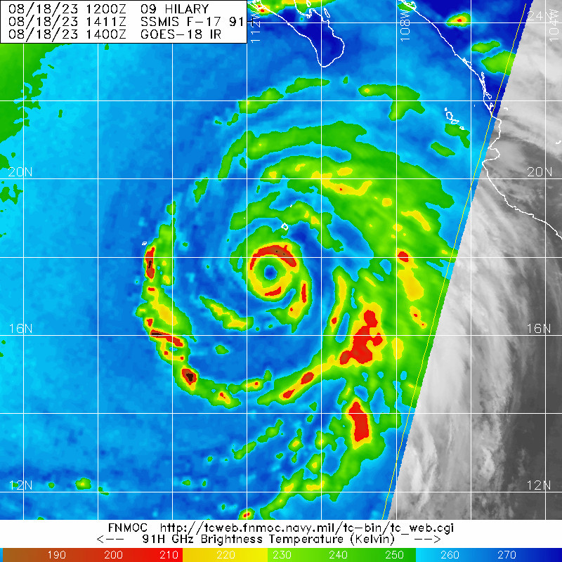
GCANE wrote:Eye has shrunk and a lot more ragged looking than a few hours ago


Unfortunately recon missed the max intensity by about 6 to 12 hours.
0 likes   

User avatar
Yellow Evan
Professional-Met
Professional-Met
Posts: 16143
Age: 27
Joined: Fri Jul 15, 2011 12:48 pm
Location: Henderson, Nevada/Honolulu, HI
Contact:

Re: EPAC: HILARY - Hurricane - Discussion: Plane on route / TS Watch for Southern California

#237 Postby Yellow Evan » Fri Aug 18, 2023 11:58 am

There’s an 18-24 window to reintensify unless another ERC starts but I think the ERC took a heavy toll on the system as usual. I don’t think Hilary is still a major hurricane.
0 likes   

SconnieCane
Category 4
Category 4
Posts: 998
Joined: Thu Aug 02, 2018 5:29 pm
Location: Madison, WI

Re: EPAC: HILARY - Hurricane - Discussion: Plane on route / TS Watch for Southern California

#238 Postby SconnieCane » Fri Aug 18, 2023 11:59 am

ElectricStorm wrote:I'm guessing the plane finds around 105-110kts and 950mb. Looked great earlier but really ragged now


Seems recon can never intercept the peak on these things. I used to think pinning down tropical cyclone intensity was a much more exact science than tornado ratings. It still is, but there's a lot more estimation and educated guesswork involved despite having the benefit of in-situ measurements (assuming that option is actually used, which in the Pacific it usually isn't).
0 likes   

Socalhurcnegirl227
Category 1
Category 1
Posts: 267
Age: 36
Joined: Mon Jun 06, 2016 6:39 pm
Location: Santa Barbara, CA

Re: EPAC: HILARY - Hurricane - Discussion: Plane on route

#239 Postby Socalhurcnegirl227 » Fri Aug 18, 2023 12:08 pm

aspen wrote:SoCal is now under a Tropical Storm Watch. I never thought I’d see that.

What a time to be alive
1 likes   
"I'm a wandress, i'm a one night stand,
dont belong to no city, dont belong to no man
i'm the violence in the pouring rain,
I'm a hurricane"

User avatar
GCANE
S2K Supporter
S2K Supporter
Posts: 11496
Joined: Mon Oct 22, 2007 8:03 am

Re: EPAC: HILARY - Hurricane - Discussion: TS Watch for Southern California

#240 Postby GCANE » Fri Aug 18, 2023 12:24 pm

Looks like recon is starting to descend
0 likes   


Return to “2023”

Who is online

Users browsing this forum: Google Adsense [Bot], Hurricane2022 and 2 guests