EPAC: JOVA - Post-Tropical - Discussion
Moderator: S2k Moderators
-
Kingarabian

- S2K Supporter

- Posts: 16348
- Joined: Sat Aug 08, 2009 3:06 am
- Location: Honolulu, Hawaii
Re: EPAC: JOVA - Hurricane - Discussion
It is winding down but should give us some fantastic visible's. Fortunately it RI'd all the way to its peak. Phenomenal system.
1 likes
RIP Kobe Bryant
-
cycloneye

- Admin

- Posts: 149275
- Age: 69
- Joined: Thu Oct 10, 2002 10:54 am
- Location: San Juan, Puerto Rico
Re: EPAC: JOVA - Hurricane - Discussion
Is over as cat 5.
EP, 11, 2023090712, , BEST, 0, 168N, 1150W, 135, 932, HU
0 likes
Visit the Caribbean-Central America Weather Thread where you can find at first post web cams,radars
and observations from Caribbean basin members Click Here
and observations from Caribbean basin members Click Here

Re: EPAC: JOVA - Hurricane - Discussion: Upgraded to Category 5
Foxfires wrote:Cyclenall wrote:Well it looks like we got some excitement tonight - I was hoping for the bump to 160 mph so kudos. I also want to know if its the fastest from TD to CAT 5, I don't know how folks search for metadata like that aside from getting some stat somewhere else and comparing.
Worldwide? JTWC has Ambali 2019 do TD -> C5 in 1.5 days, which is faster than Jova (~2 days).
EPac? Idk, but it's not Patricia somehow.
I forgot to check your excellent TC stat list you posted in the Spring, you should've got more credit for that.
0 likes

Re: EPAC: JOVA - Hurricane - Discussion
Jova is weakening fast, I don't think it'll have a chance to regain cat 5. Raw T# ADT (6.0) now 'only' supports 115 kt, 948 mb. Assuming its actual peak was 150 - 155 kt that's a weakening of of 35 - 40 kt over the last 6 hours. Still Jova will be remembered for one of the most impressive RI phases ever seen in the EPAC. I wish we could've had recon at its peak (or at all).
2 likes

Re: EPAC: JOVA - Hurricane - Discussion: Upgraded to Category 5
Cyclenall wrote:Foxfires wrote:Cyclenall wrote:Well it looks like we got some excitement tonight - I was hoping for the bump to 160 mph so kudos. I also want to know if its the fastest from TD to CAT 5, I don't know how folks search for metadata like that aside from getting some stat somewhere else and comparing.
Worldwide? JTWC has Ambali 2019 do TD -> C5 in 1.5 days, which is faster than Jova (~2 days).
EPac? Idk, but it's not Patricia somehow.
I forgot to check your excellent TC stat list you posted in the Spring, you should've got more credit for that.
Thank you very much, but that's not on the list actually. I only listed 24h wind speed (and pressure) intensifications, regardless of category, since I thought it would be too much text to include both. I don't know, maybe I should add the NAtl Wikipedia kind of intensification records.
I actually found Ambali's thing by just going through the data of storms with really high intensification.
0 likes
-
Sciencerocks
- Category 5

- Posts: 10181
- Age: 40
- Joined: Thu Jul 06, 2017 1:51 am

-
Hurricane2022

- Category 5
- Posts: 2016
- Joined: Tue Aug 23, 2022 11:38 pm
- Location: Araçatuba, Brazil
Re: EPAC: JOVA - Hurricane - Discussion
Sciencerocks wrote:https://imagizer.imageshack.com/img923/9073/Ms4wPx.gif
Intensified like Patricia, collapsed like Patricia.
1 likes
Sorry for the bad English sometimes...!
For reliable and detailed information for any meteorological phenomenon, please consult the National Hurricane Center, Joint Typhoon Warning Center , or your local Meteo Center.
--------
ECCE OMNIA NOVA FACIAM (Ap 21,5).
For reliable and detailed information for any meteorological phenomenon, please consult the National Hurricane Center, Joint Typhoon Warning Center , or your local Meteo Center.
--------
ECCE OMNIA NOVA FACIAM (Ap 21,5).
-
cycloneye
- Admin
- Posts: 149275
- Age: 69
- Joined: Thu Oct 10, 2002 10:54 am
- Location: San Juan, Puerto Rico
Re: EPAC: JOVA - Hurricane - Discussion
Hurricane Jova Discussion Number 12
NWS National Hurricane Center Miami FL EP112023
800 AM PDT Thu Sep 07 2023
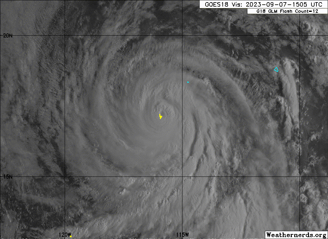
Infrared satellite imagery shows that cloud tops have warmed in the
eyewall of Jova. An earlier SSMIS microwave passed depicts that Jova
is starting to undergo an eyewall replacement cycle, with an outer
concentric ring developing, and the inner core starting to collapse.
In the past hour or so, hi-res GOES-18 1-minute imagery shows that
the eye has become cloud filled, further confirming the microwave
pass from earlier that Jova is undergoing an eyewall replacement
cycle. The subjective and objective Dvorak estimates have decreased
slightly with this advisory between 130-140 kt. Given the current
eyewall replacement cycle and warming cloud tops, the initial
intensity for this advisory is 135 kt.
With the beginning stages of an eyewall replacement cycle, Jova
may experience some short-term intensity fluctuations. The NHC
forecast predicts slow weakening while Jova undergoes these changes.
By the time the eyewall replacement is complete, Jova will
start to cross a sharp sea surface temperature gradient into
cooler waters, and into a drier, more stable airmass. By the end of
the forecast period, simulated satellite imagery from the GFS model
suggests the cyclone will be devoid of convection, and the official
forecast shows Jova to be a post-tropical remnant low by day 5.
The hurricane continues to move west-northwestward at 14 kt around
the edge of a mid-level ridge centered over northern Mexico. The
ridge is expected to be the dominate steering feature during the
next few days and Jova should maintain the same general motion until
the end of the forecast period. At that point the weakening,
shallow vortex should turn westward in the low-level flow. The NHC
track forecast has been shifted slightly to the north between the
HCCA and TVCN consensus aids.
FORECAST POSITIONS AND MAX WINDS
INIT 07/1500Z 17.1N 115.7W 135 KT 155 MPH
12H 08/0000Z 18.0N 117.7W 125 KT 145 MPH
24H 08/1200Z 19.3N 120.4W 110 KT 125 MPH
36H 09/0000Z 20.5N 123.0W 90 KT 105 MPH
48H 09/1200Z 21.8N 125.2W 75 KT 85 MPH
60H 10/0000Z 23.1N 127.0W 60 KT 70 MPH
72H 10/1200Z 24.2N 128.3W 45 KT 50 MPH
96H 11/1200Z 25.4N 130.7W 30 KT 35 MPH
120H 12/1200Z 25.3N 133.6W 25 KT 30 MPH...POST-TROP/REMNT LOW
$$
Forecaster Kelly/Camposano
NWS National Hurricane Center Miami FL EP112023
800 AM PDT Thu Sep 07 2023
Infrared satellite imagery shows that cloud tops have warmed in the
eyewall of Jova. An earlier SSMIS microwave passed depicts that Jova
is starting to undergo an eyewall replacement cycle, with an outer
concentric ring developing, and the inner core starting to collapse.
In the past hour or so, hi-res GOES-18 1-minute imagery shows that
the eye has become cloud filled, further confirming the microwave
pass from earlier that Jova is undergoing an eyewall replacement
cycle. The subjective and objective Dvorak estimates have decreased
slightly with this advisory between 130-140 kt. Given the current
eyewall replacement cycle and warming cloud tops, the initial
intensity for this advisory is 135 kt.
With the beginning stages of an eyewall replacement cycle, Jova
may experience some short-term intensity fluctuations. The NHC
forecast predicts slow weakening while Jova undergoes these changes.
By the time the eyewall replacement is complete, Jova will
start to cross a sharp sea surface temperature gradient into
cooler waters, and into a drier, more stable airmass. By the end of
the forecast period, simulated satellite imagery from the GFS model
suggests the cyclone will be devoid of convection, and the official
forecast shows Jova to be a post-tropical remnant low by day 5.
The hurricane continues to move west-northwestward at 14 kt around
the edge of a mid-level ridge centered over northern Mexico. The
ridge is expected to be the dominate steering feature during the
next few days and Jova should maintain the same general motion until
the end of the forecast period. At that point the weakening,
shallow vortex should turn westward in the low-level flow. The NHC
track forecast has been shifted slightly to the north between the
HCCA and TVCN consensus aids.
FORECAST POSITIONS AND MAX WINDS
INIT 07/1500Z 17.1N 115.7W 135 KT 155 MPH
12H 08/0000Z 18.0N 117.7W 125 KT 145 MPH
24H 08/1200Z 19.3N 120.4W 110 KT 125 MPH
36H 09/0000Z 20.5N 123.0W 90 KT 105 MPH
48H 09/1200Z 21.8N 125.2W 75 KT 85 MPH
60H 10/0000Z 23.1N 127.0W 60 KT 70 MPH
72H 10/1200Z 24.2N 128.3W 45 KT 50 MPH
96H 11/1200Z 25.4N 130.7W 30 KT 35 MPH
120H 12/1200Z 25.3N 133.6W 25 KT 30 MPH...POST-TROP/REMNT LOW
$$
Forecaster Kelly/Camposano
0 likes
Visit the Caribbean-Central America Weather Thread where you can find at first post web cams,radars
and observations from Caribbean basin members Click Here
and observations from Caribbean basin members Click Here
-
galaxy401

- Category 5
- Posts: 2446
- Age: 30
- Joined: Sat Aug 25, 2012 9:04 pm
- Location: Casa Grande, Arizona
Re: EPAC: JOVA - Hurricane - Discussion
Discussion for this storm vanished after Jova weakened. Looks like it's nearly completed the EWRC. Bigger eye emerging.
1 likes
Got my eyes on moving right into Hurricane Alley: Florida.
-
cycloneye
- Admin
- Posts: 149275
- Age: 69
- Joined: Thu Oct 10, 2002 10:54 am
- Location: San Juan, Puerto Rico
Re: EPAC: JOVA - Hurricane - Discussion

1 likes
Visit the Caribbean-Central America Weather Thread where you can find at first post web cams,radars
and observations from Caribbean basin members Click Here
and observations from Caribbean basin members Click Here
-
Sciencerocks
- Category 5
- Posts: 10181
- Age: 40
- Joined: Thu Jul 06, 2017 1:51 am
-
Hurricane2022
- Category 5
- Posts: 2016
- Joined: Tue Aug 23, 2022 11:38 pm
- Location: Araçatuba, Brazil
Re: EPAC: JOVA - Hurricane - Discussion

Last edited by Hurricane2022 on Thu Sep 07, 2023 3:22 pm, edited 1 time in total.
1 likes
Sorry for the bad English sometimes...!
For reliable and detailed information for any meteorological phenomenon, please consult the National Hurricane Center, Joint Typhoon Warning Center , or your local Meteo Center.
--------
ECCE OMNIA NOVA FACIAM (Ap 21,5).
For reliable and detailed information for any meteorological phenomenon, please consult the National Hurricane Center, Joint Typhoon Warning Center , or your local Meteo Center.
--------
ECCE OMNIA NOVA FACIAM (Ap 21,5).
-
bob rulz
- Category 5
- Posts: 1711
- Age: 35
- Joined: Sat Jan 28, 2006 7:30 pm
- Location: Salt Lake City, Utah
Re: EPAC: JOVA - Hurricane - Discussion
I would be surprised if the NHC didn't up the peak intensity to 150 or 155kts in the TCR. Gonna have to wait a few months though, sadly. I think that was definitely the most perfect-looking storm in the EPAC since Patricia though.
2 likes
-
cycloneye
- Admin
- Posts: 149275
- Age: 69
- Joined: Thu Oct 10, 2002 10:54 am
- Location: San Juan, Puerto Rico
Re: EPAC: JOVA - Hurricane - Discussion
EP, 11, 2023090718, , BEST, 0, 174N, 1166W, 125, 941, HU
0 likes
Visit the Caribbean-Central America Weather Thread where you can find at first post web cams,radars
and observations from Caribbean basin members Click Here
and observations from Caribbean basin members Click Here
-
Hurricane2022
- Category 5
- Posts: 2016
- Joined: Tue Aug 23, 2022 11:38 pm
- Location: Araçatuba, Brazil
Re: EPAC: JOVA - Hurricane - Discussion
https://twitter.com/zeb199818/status/1699854547177599468
https://twitter.com/zeb199818/status/1699852416194343055
https://twitter.com/zeb199818/status/1699852416194343055
1 likes
Sorry for the bad English sometimes...!
For reliable and detailed information for any meteorological phenomenon, please consult the National Hurricane Center, Joint Typhoon Warning Center , or your local Meteo Center.
--------
ECCE OMNIA NOVA FACIAM (Ap 21,5).
For reliable and detailed information for any meteorological phenomenon, please consult the National Hurricane Center, Joint Typhoon Warning Center , or your local Meteo Center.
--------
ECCE OMNIA NOVA FACIAM (Ap 21,5).
-
Sciencerocks
- Category 5
- Posts: 10181
- Age: 40
- Joined: Thu Jul 06, 2017 1:51 am
-
ElectricStorm

- Category 5
- Posts: 5139
- Age: 25
- Joined: Tue Aug 13, 2019 11:23 pm
- Location: Norman, OK
Re: EPAC: JOVA - Hurricane - Discussion
BULLETIN
Hurricane Jova Advisory Number 13
NWS National Hurricane Center Miami FL EP112023
200 PM PDT Thu Sep 07 2023
...MAJOR HURRICANE JOVA MOVING WEST-NORTHWESTWARD...
SUMMARY OF 200 PM PDT...2100 UTC...INFORMATION
----------------------------------------------
LOCATION...17.7N 117.3W
ABOUT 600 MI...965 KM SW OF THE SOUTHERN TIP OF BAJA CALIFORNIA
MAXIMUM SUSTAINED WINDS...145 MPH...230 KM/H
PRESENT MOVEMENT...WNW OR 295 DEGREES AT 17 MPH...28 KM/H
MINIMUM CENTRAL PRESSURE...941 MB...27.79 INCHES
0 likes
B.S Meteorology, University of Oklahoma '25
Please refer to the NHC, NWS, or SPC for official information.
Please refer to the NHC, NWS, or SPC for official information.
-
cycloneye
- Admin
- Posts: 149275
- Age: 69
- Joined: Thu Oct 10, 2002 10:54 am
- Location: San Juan, Puerto Rico
Re: EPAC: JOVA - Hurricane - Discussion
Hurricane Jova Discussion Number 13
NWS National Hurricane Center Miami FL EP112023
200 PM PDT Thu Sep 07 2023
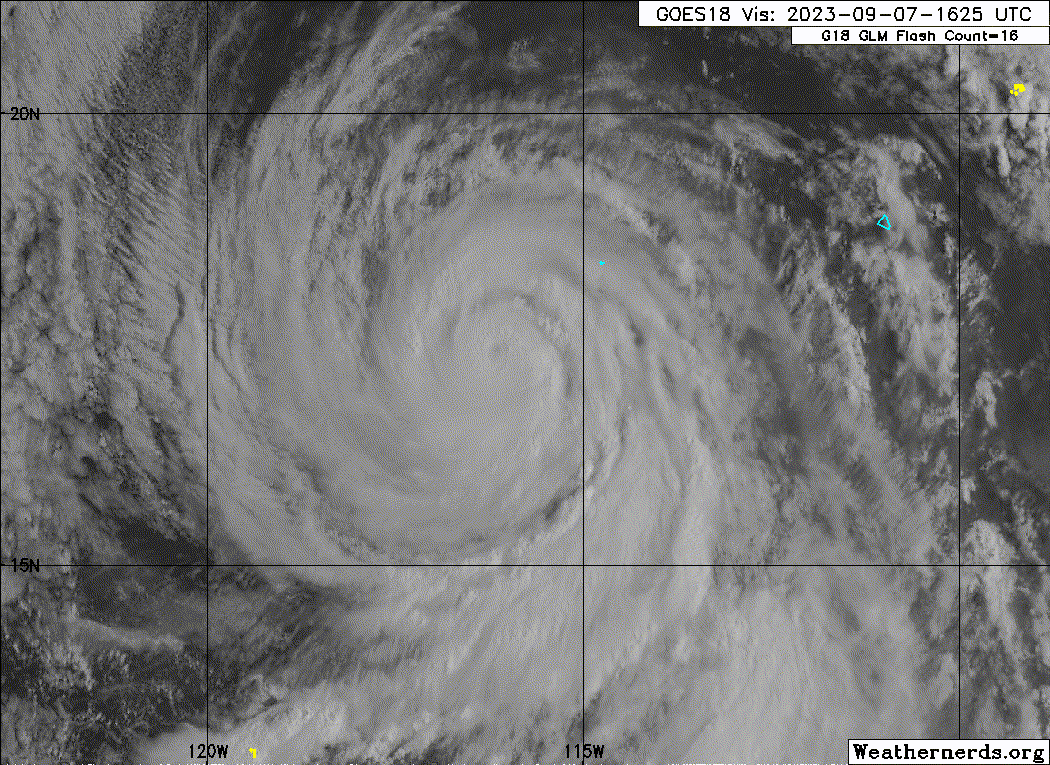
Visible satellite imagery this afternoon shows Jova is gradually
weakening. The eye has been cloud-filled for much of the day, with
dry air trying to wrap into the southern and eastern side of the
system. SSMIS microwave imagery depicts the earlier thick concentric
eyewall is starting to thin, with the inner core becoming less
pronounced. Infrared imagery shows this as well with the infrared
cloud tops warming throughout the day as well. Subjective satellite
estimates were lower this advisory, with Dvorak final-T numbers of
6.0 and CI numbers of 7.0 from both TAFB and SAB. Given the
structural changes depicted in microwave and visible imagery, the
initial intensity for this advisory is lowered to 125 kt, which
falls between the latest Dvorak estimates.
Jova may continue to experience some short-term intensity
fluctuations as it undergoes structural changes and moves into a
less favorable environment. In about 24 h, Jova will cross a sharp
sea surface temperature gradient into cooler waters, while it moves
into a drier, more stable airmass. This will induce a steady
weakening trend over the next few days. By the end of the forecast
period, simulated satellite imagery from the GFS and ECMWF models
suggests the cyclone will be devoid of convection, and the official
forecast shows Jova becoming a post-tropical remnant low by 96 h.
The hurricane continues to move west-northwestward at 15 kt around a
mid-level ridge centered over northern Mexico. Jova should generally
follow this motion for the next several days. As the system weakens
and becomes a shallow vortex, a turn toward the west and southwest
within the low-level flow is anticipated. The guidance envelope
remains in good agreement, and the track forecast is similar to the
previous advisory.
FORECAST POSITIONS AND MAX WINDS
INIT 07/2100Z 17.7N 117.3W 125 KT 145 MPH
12H 08/0600Z 18.6N 119.4W 110 KT 125 MPH
24H 08/1800Z 19.8N 122.0W 95 KT 110 MPH
36H 09/0600Z 21.0N 124.4W 80 KT 90 MPH
48H 09/1800Z 22.4N 126.4W 60 KT 70 MPH
60H 10/0600Z 23.6N 127.8W 50 KT 60 MPH
72H 10/1800Z 24.5N 129.1W 40 KT 45 MPH
96H 11/1800Z 25.0N 131.1W 30 KT 35 MPH...POST-TROP/REMNT LOW
120H 12/1800Z 24.2N 133.2W 25 KT 30 MPH...POST-TROP/REMNT LOW
$$
Forecaster Kelly
NWS National Hurricane Center Miami FL EP112023
200 PM PDT Thu Sep 07 2023
Visible satellite imagery this afternoon shows Jova is gradually
weakening. The eye has been cloud-filled for much of the day, with
dry air trying to wrap into the southern and eastern side of the
system. SSMIS microwave imagery depicts the earlier thick concentric
eyewall is starting to thin, with the inner core becoming less
pronounced. Infrared imagery shows this as well with the infrared
cloud tops warming throughout the day as well. Subjective satellite
estimates were lower this advisory, with Dvorak final-T numbers of
6.0 and CI numbers of 7.0 from both TAFB and SAB. Given the
structural changes depicted in microwave and visible imagery, the
initial intensity for this advisory is lowered to 125 kt, which
falls between the latest Dvorak estimates.
Jova may continue to experience some short-term intensity
fluctuations as it undergoes structural changes and moves into a
less favorable environment. In about 24 h, Jova will cross a sharp
sea surface temperature gradient into cooler waters, while it moves
into a drier, more stable airmass. This will induce a steady
weakening trend over the next few days. By the end of the forecast
period, simulated satellite imagery from the GFS and ECMWF models
suggests the cyclone will be devoid of convection, and the official
forecast shows Jova becoming a post-tropical remnant low by 96 h.
The hurricane continues to move west-northwestward at 15 kt around a
mid-level ridge centered over northern Mexico. Jova should generally
follow this motion for the next several days. As the system weakens
and becomes a shallow vortex, a turn toward the west and southwest
within the low-level flow is anticipated. The guidance envelope
remains in good agreement, and the track forecast is similar to the
previous advisory.
FORECAST POSITIONS AND MAX WINDS
INIT 07/2100Z 17.7N 117.3W 125 KT 145 MPH
12H 08/0600Z 18.6N 119.4W 110 KT 125 MPH
24H 08/1800Z 19.8N 122.0W 95 KT 110 MPH
36H 09/0600Z 21.0N 124.4W 80 KT 90 MPH
48H 09/1800Z 22.4N 126.4W 60 KT 70 MPH
60H 10/0600Z 23.6N 127.8W 50 KT 60 MPH
72H 10/1800Z 24.5N 129.1W 40 KT 45 MPH
96H 11/1800Z 25.0N 131.1W 30 KT 35 MPH...POST-TROP/REMNT LOW
120H 12/1800Z 24.2N 133.2W 25 KT 30 MPH...POST-TROP/REMNT LOW
$$
Forecaster Kelly
0 likes
Visit the Caribbean-Central America Weather Thread where you can find at first post web cams,radars
and observations from Caribbean basin members Click Here
and observations from Caribbean basin members Click Here
-
Sciencerocks
- Category 5
- Posts: 10181
- Age: 40
- Joined: Thu Jul 06, 2017 1:51 am
-
cycloneye
- Admin
- Posts: 149275
- Age: 69
- Joined: Thu Oct 10, 2002 10:54 am
- Location: San Juan, Puerto Rico
Re: EPAC: JOVA - Hurricane - Discussion
Hurricane Jova Discussion Number 14
NWS National Hurricane Center Miami FL EP112023
800 PM PDT Thu Sep 07 2023
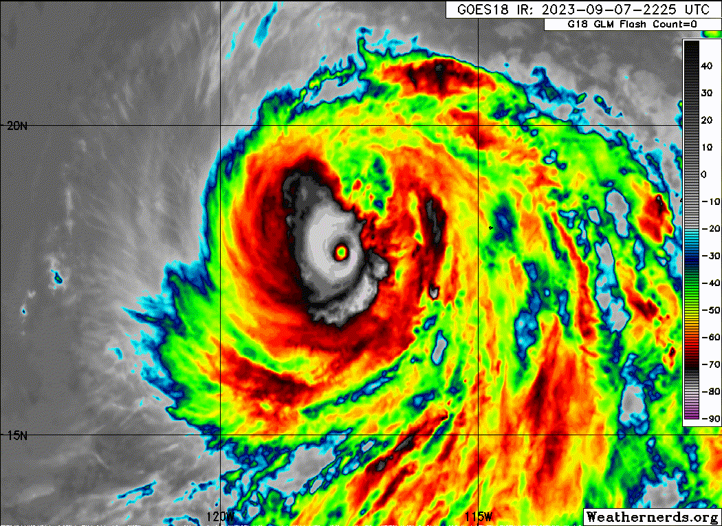
The satellite presentation of Jova has changed drastically since
yesterday evening. Earlier 21 UTC AMSR2 microwave data showed a
large moat surrounding the very small inner core of the hurricane,
with a ragged secondary outer eyewall and fragmented curved bands of
convection well to the east and southeast of the center. The eye of
the hurricane has become cloud filled, and a convective asymmetry
has developed that is likely a product of some northeasterly shear
affecting Jova. All indications are that Jova is weakening, which is
consistent with the latest satellite intensity estimates. Based on a
blend of the latest data-T and current intensity Dvorak estimates
from TAFB and SAB, the initial intensity is lowered to 110 kt,
which also agrees well with recent UW-CIMSS ADT estimates.
Continued weakening is expected over the next several days. Jova
will cross a significant SST gradient and move over progressively
cooler waters during the next several days while the hurricane gains
latitude. This track will also bring Jova into a drier and more
stable environment, making it increasingly difficult for the cyclone
to maintain its convective structure. This forecast update shows a
faster rate of weakening that is supported by the latest intensity
guidance. The global models agree that Jova is likely to be devoid
of organized convection by early next week, and the NHC forecast
shows post-tropical status in 96 h.
The eye of Jova has wobbled some during the past several hours, but
the longer-term motion remains west-northwestward (295/15 kt). The
hurricane is forecast to continue in this general direction for the
next couple of days while moving around the southwestern periphery
of a mid-level ridge centered over the southwestern United States. A
brief turn to the northwest is shown between 48-72 h as the ridge
becomes reoriented to the east of Jova. By days 4 and 5, the shallow
cyclone should slowly turn westward within the low-level flow. The
latest NHC track forecast is slower than the previous one at 72 h
and beyond, bringing it into better agreement with the HCCA and TVCN
aids. Otherwise, no notable changes were made with this advisory.
FORECAST POSITIONS AND MAX WINDS
INIT 08/0300Z 18.3N 118.6W 110 KT 125 MPH
12H 08/1200Z 19.1N 120.6W 95 KT 110 MPH
24H 09/0000Z 20.3N 123.1W 80 KT 90 MPH
36H 09/1200Z 21.6N 125.2W 65 KT 75 MPH
48H 10/0000Z 23.0N 126.8W 55 KT 65 MPH
60H 10/1200Z 24.0N 127.9W 45 KT 50 MPH
72H 11/0000Z 24.6N 128.8W 40 KT 45 MPH
96H 12/0000Z 24.8N 130.5W 35 KT 40 MPH...POST-TROPICAL
120H 13/0000Z 24.5N 133.0W 25 KT 30 MPH...POST-TROP/REMNT LOW
$$
Forecaster Reinhart
NWS National Hurricane Center Miami FL EP112023
800 PM PDT Thu Sep 07 2023
The satellite presentation of Jova has changed drastically since
yesterday evening. Earlier 21 UTC AMSR2 microwave data showed a
large moat surrounding the very small inner core of the hurricane,
with a ragged secondary outer eyewall and fragmented curved bands of
convection well to the east and southeast of the center. The eye of
the hurricane has become cloud filled, and a convective asymmetry
has developed that is likely a product of some northeasterly shear
affecting Jova. All indications are that Jova is weakening, which is
consistent with the latest satellite intensity estimates. Based on a
blend of the latest data-T and current intensity Dvorak estimates
from TAFB and SAB, the initial intensity is lowered to 110 kt,
which also agrees well with recent UW-CIMSS ADT estimates.
Continued weakening is expected over the next several days. Jova
will cross a significant SST gradient and move over progressively
cooler waters during the next several days while the hurricane gains
latitude. This track will also bring Jova into a drier and more
stable environment, making it increasingly difficult for the cyclone
to maintain its convective structure. This forecast update shows a
faster rate of weakening that is supported by the latest intensity
guidance. The global models agree that Jova is likely to be devoid
of organized convection by early next week, and the NHC forecast
shows post-tropical status in 96 h.
The eye of Jova has wobbled some during the past several hours, but
the longer-term motion remains west-northwestward (295/15 kt). The
hurricane is forecast to continue in this general direction for the
next couple of days while moving around the southwestern periphery
of a mid-level ridge centered over the southwestern United States. A
brief turn to the northwest is shown between 48-72 h as the ridge
becomes reoriented to the east of Jova. By days 4 and 5, the shallow
cyclone should slowly turn westward within the low-level flow. The
latest NHC track forecast is slower than the previous one at 72 h
and beyond, bringing it into better agreement with the HCCA and TVCN
aids. Otherwise, no notable changes were made with this advisory.
FORECAST POSITIONS AND MAX WINDS
INIT 08/0300Z 18.3N 118.6W 110 KT 125 MPH
12H 08/1200Z 19.1N 120.6W 95 KT 110 MPH
24H 09/0000Z 20.3N 123.1W 80 KT 90 MPH
36H 09/1200Z 21.6N 125.2W 65 KT 75 MPH
48H 10/0000Z 23.0N 126.8W 55 KT 65 MPH
60H 10/1200Z 24.0N 127.9W 45 KT 50 MPH
72H 11/0000Z 24.6N 128.8W 40 KT 45 MPH
96H 12/0000Z 24.8N 130.5W 35 KT 40 MPH...POST-TROPICAL
120H 13/0000Z 24.5N 133.0W 25 KT 30 MPH...POST-TROP/REMNT LOW
$$
Forecaster Reinhart
0 likes
Visit the Caribbean-Central America Weather Thread where you can find at first post web cams,radars
and observations from Caribbean basin members Click Here
and observations from Caribbean basin members Click Here
Who is online
Users browsing this forum: No registered users and 142 guests