ATL: IDALIA - Models

Moderator: S2k Moderators

Message
Author
BobHarlem
Category 5
Category 5
Posts: 2034
Joined: Thu Oct 20, 2005 6:11 pm

Re: ATL: TEN - Models

#321 Postby BobHarlem » Sun Aug 27, 2023 12:31 am

Ianswfl wrote:
BobHarlem wrote:0z HAFS-B Borderline Cat 4/5 into St. Marks
https://i.imgur.com/H2vL6C1.png

0z HAFS-A Cat 4 Just East of St Marks, closer to Perry.
https://i.imgur.com/RIWhx3E.png


Top one is 850mb level not surface winds.

Fixed, too many links flying around. Still getting close to cat 5 there. Recon usually does wonders for these types of models so tomorrow will be something to watch.
Last edited by BobHarlem on Sun Aug 27, 2023 12:33 am, edited 2 times in total.
0 likes   

PavelGaborik10
Category 1
Category 1
Posts: 454
Joined: Tue Sep 04, 2018 3:23 pm

Re: ATL: TEN - Models

#322 Postby PavelGaborik10 » Sun Aug 27, 2023 12:31 am

Substantial shift W tonight. Too soon to say, but there are going to be a lot of people eating crow if the GFS gets the last laugh in regards to landfall here.

Recon data will be extremely important tomorrow
1 likes   

LarryWx
Category 5
Category 5
Posts: 6247
Joined: Sun Sep 07, 2003 2:04 pm
Location: GA

Re: ATL: TEN - Models

#323 Postby LarryWx » Sun Aug 27, 2023 12:31 am

sarcean wrote:I do not know the in and outs of every single model but how many of them really take into account the super warm Gulf that is near 100 degrees in places (record temps). When it does landfall the storm should still be intensifying over those jet fuel like waters.


There are no portions of the Gulf that are currently near 100F. In July, Manatee Bay buoy hit 100 one day and 101 the next. But those were recorded in a very shallow, protected area just offshore S FL with a sunlight absorbing dark bottom that could be seen from above. Also, these water temps were hit only late in afternoon for a short period followed by cooling to near 90 each night. And now the hottest afternoon water temps are "only" near 90.
3 likes   
Personal Forecast Disclaimer:
The posts in this forum are NOT official forecasts and should not be used as such. They are just the opinion of the poster and may or may not be backed by sound meteorological data. They are NOT endorsed by any professional institution or storm2k.org. For official information, please refer to the NHC and NWS products.

BobHarlem
Category 5
Category 5
Posts: 2034
Joined: Thu Oct 20, 2005 6:11 pm

Re: ATL: TEN - Models

#324 Postby BobHarlem » Sun Aug 27, 2023 12:37 am

0z HMON around Port St. Joe
Image
0 likes   

User avatar
Blown Away
S2K Supporter
S2K Supporter
Posts: 10140
Joined: Wed May 26, 2004 6:17 am

Re: ATL: TEN - Models

#325 Postby Blown Away » Sun Aug 27, 2023 12:37 am

If the HAFS are correct with a MH landfall in Big Bend, that is very rare. GFS is rarely correct when it’s the west outlier. There is always a first I guess.
1 likes   
Hurricane Eye Experience: David 79, Irene 99, Frances 04, Jeanne 04, Wilma 05... EYE COMING MY WAY IN 2024…
Hurricane Brush Experience: Andrew 92, Erin 95, Floyd 99, Matthew 16, Irma 17, Ian 22, Nicole 22…

User avatar
stormhunter7
Category 2
Category 2
Posts: 761
Joined: Mon May 26, 2008 3:13 pm
Location: Panama City Beach, Florida
Contact:

Re: ATL: TEN - Models

#326 Postby stormhunter7 » Sun Aug 27, 2023 1:28 am

Looks like slight west shift in 00z Euro and little stronger?
0 likes   
The following post is NOT an official forecast and should not be used as such. It is just the opinion of the poster and may or may not be backed by sound meteorological data. It is NOT endorsed by any professional institution including storm2k.org For Official Information please refer to the NHC and NWS products. http://www.nhc.noaa.gov

LarryWx
Category 5
Category 5
Posts: 6247
Joined: Sun Sep 07, 2003 2:04 pm
Location: GA

Re: ATL: TEN - Models

#327 Postby LarryWx » Sun Aug 27, 2023 1:34 am

stormhunter7 wrote:Looks like slight west shift in 00z Euro and little stronger?


Yes, slight NW shift. 987 mb landfall at NW Big Bend 2PM on Wednesday (8/30). Very close to 0Z UKMET landfall point. Strongest Euro run so far. Earlier landfalls were with SLP in low 990s. A big mess for the Big Bend.
0 likes   
Personal Forecast Disclaimer:
The posts in this forum are NOT official forecasts and should not be used as such. They are just the opinion of the poster and may or may not be backed by sound meteorological data. They are NOT endorsed by any professional institution or storm2k.org. For official information, please refer to the NHC and NWS products.

User avatar
cycloneye
Admin
Admin
Posts: 143897
Age: 68
Joined: Thu Oct 10, 2002 10:54 am
Location: San Juan, Puerto Rico

Re: ATL: TEN - Models

#328 Postby cycloneye » Sun Aug 27, 2023 5:31 am

Strongest GFS run yet at 06z and a little right, 964 mbs to big bend.

Image
0 likes   
Visit the Caribbean-Central America Weather Thread where you can find at first post web cams,radars
and observations from Caribbean basin members Click Here

User avatar
N2FSU
S2K Supporter
S2K Supporter
Posts: 1062
Joined: Thu Sep 04, 2003 2:04 pm
Location: Tallahassee, FL

Re: ATL: TEN - Models

#329 Postby N2FSU » Sun Aug 27, 2023 5:50 am

0z HAFS-B would be catastrophic for those of us in Tallahassee and this areaImage


Sent from my iPhone using Tapatalk
1 likes   

otowntiger
Category 5
Category 5
Posts: 1921
Joined: Tue Aug 31, 2004 7:06 pm

Re: ATL: TEN - Models

#330 Postby otowntiger » Sun Aug 27, 2023 6:14 am

N2FSU wrote:0z HAFS-B would be catastrophic for those of us in Tallahassee and this areahttps://uploads.tapatalk-cdn.com/20230827/cf055b4dad3d0f54c49b1c0e50d763c9.jpg


Sent from my iPhone using Tapatalk
yep- that would be a worst case scenario for metro Tallahassee- cat 4 coming in just to your southwest- I know you are safe from storm surge being 30+ miles inland, but Michael proved if the storm was strong enough, moving at the a good clip and comes in at the right angle, inland wind damage even as far inland as you are can be very significant. Just look at Marianna during Michael- 50 miles inland but they were absolutely devastated.
1 likes   

User avatar
Blown Away
S2K Supporter
S2K Supporter
Posts: 10140
Joined: Wed May 26, 2004 6:17 am

Re: ATL: TEN - Models

#331 Postby Blown Away » Sun Aug 27, 2023 6:19 am

Image

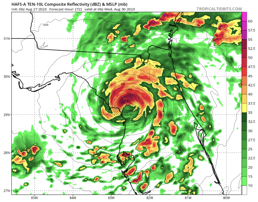
06z HAFS models >1 degree SE of 00z with landfall just N of Tampa near Crystal River. So it appears the longer TD10 takes to move out of the Caribbean that delay may result in E adjustments. Note, not as strong on the 06z compared to 00z.
1 likes   
Hurricane Eye Experience: David 79, Irene 99, Frances 04, Jeanne 04, Wilma 05... EYE COMING MY WAY IN 2024…
Hurricane Brush Experience: Andrew 92, Erin 95, Floyd 99, Matthew 16, Irma 17, Ian 22, Nicole 22…

User avatar
chris_fit
Category 5
Category 5
Posts: 3222
Age: 42
Joined: Wed Sep 10, 2003 11:58 pm
Location: Tampa Bay Area, FL

Re: ATL: TEN - Models

#332 Postby chris_fit » Sun Aug 27, 2023 6:21 am

06z GFS is slightly E of the 00z run.
1 likes   

TallyTracker
Category 2
Category 2
Posts: 720
Joined: Thu Oct 11, 2018 2:46 pm

Re: ATL: TEN - Models

#333 Postby TallyTracker » Sun Aug 27, 2023 6:24 am

BobHarlem wrote:0z HAFS-B Borderline Cat 4/5 into St. Marks
https://i.imgur.com/TMmQjA3.png

0z HAFS-A Cat 4 Just East of St Marks, closer to Perry.
https://i.imgur.com/RIWhx3E.png

We need the recon.


That would likely result in the highest recorded storm surge ever. The peak of Apalachee Bay is the most surge prone location in the entire Atlantic basin.
1 likes   
Fran '96, Georges '98, Gordon '00, Gabrielle '01, Charley '04, Frances '04, Jeanne '04, Barry '07, Fay '08, Debby '12, Matthew '16, Emily '17, Irma '17, Michael ‘18, Elsa ‘21, Fred ‘21, Mindy ‘21, Nicole ‘22, Idalia ‘23, Debby ‘24, Helene ‘24

User avatar
Blown Away
S2K Supporter
S2K Supporter
Posts: 10140
Joined: Wed May 26, 2004 6:17 am

Re: ATL: TEN - Models

#334 Postby Blown Away » Sun Aug 27, 2023 6:29 am

TallyTracker wrote:
BobHarlem wrote:0z HAFS-B Borderline Cat 4/5 into St. Marks
https://i.imgur.com/TMmQjA3.png

0z HAFS-A Cat 4 Just East of St Marks, closer to Perry.
https://i.imgur.com/RIWhx3E.png

We need the recon.


That would likely result in the highest recorded storm surge ever. The peak of Apalachee Bay is the most surge prone location in the entire Atlantic basin.


Yes it would, I’m think of my little fishing hole in Steinhatchee. Yikes!
0 likes   
Hurricane Eye Experience: David 79, Irene 99, Frances 04, Jeanne 04, Wilma 05... EYE COMING MY WAY IN 2024…
Hurricane Brush Experience: Andrew 92, Erin 95, Floyd 99, Matthew 16, Irma 17, Ian 22, Nicole 22…

User avatar
Blown Away
S2K Supporter
S2K Supporter
Posts: 10140
Joined: Wed May 26, 2004 6:17 am

Re: ATL: TEN - Models

#335 Postby Blown Away » Sun Aug 27, 2023 6:30 am

Image

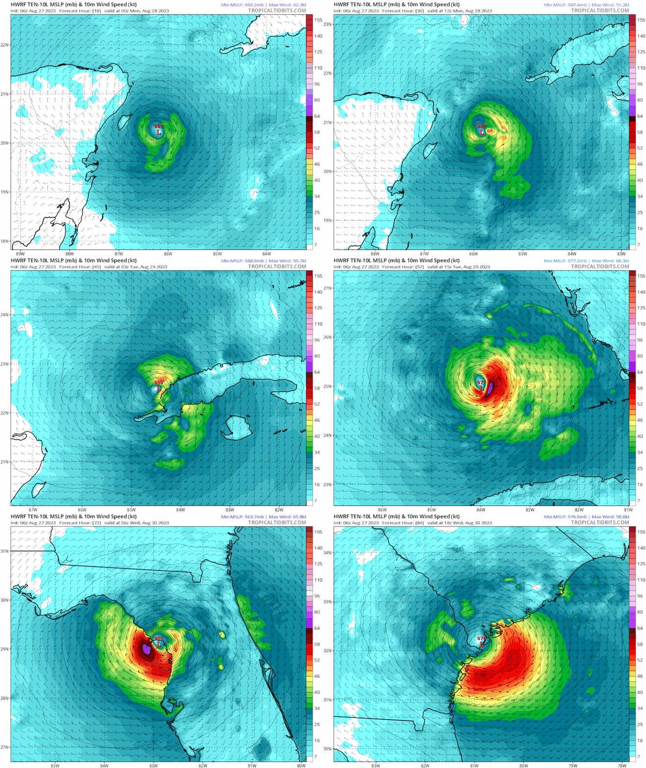
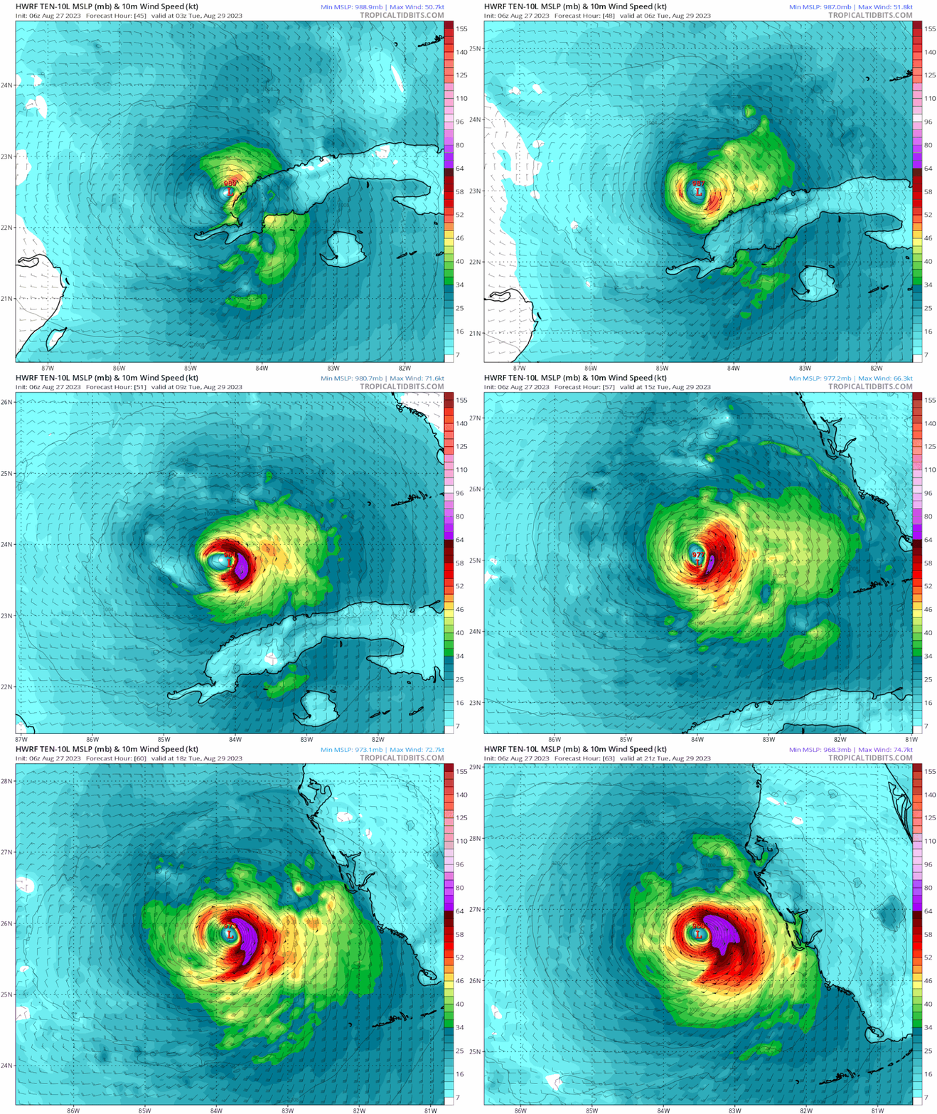
06z HWRF… Full degree SE of 00z.
Last edited by Blown Away on Sun Aug 27, 2023 7:02 am, edited 1 time in total.
0 likes   
Hurricane Eye Experience: David 79, Irene 99, Frances 04, Jeanne 04, Wilma 05... EYE COMING MY WAY IN 2024…
Hurricane Brush Experience: Andrew 92, Erin 95, Floyd 99, Matthew 16, Irma 17, Ian 22, Nicole 22…

Ianswfl
Category 1
Category 1
Posts: 482
Joined: Thu Mar 23, 2023 11:11 pm

Re: ATL: TEN - Models

#336 Postby Ianswfl » Sun Aug 27, 2023 6:56 am

Hwrf running. Trying to pull a charley. Sharp turn, maybe sarasota this run
0 likes   

User avatar
gatorcane
S2K Supporter
S2K Supporter
Posts: 23689
Age: 47
Joined: Sun Mar 13, 2005 3:54 pm
Location: Boca Raton, FL

Re: ATL: TEN - Models

#337 Postby gatorcane » Sun Aug 27, 2023 6:58 am

06Z HWRF way east:

Image
0 likes   

User avatar
chris_fit
Category 5
Category 5
Posts: 3222
Age: 42
Joined: Wed Sep 10, 2003 11:58 pm
Location: Tampa Bay Area, FL

Re: ATL: TEN - Models

#338 Postby chris_fit » Sun Aug 27, 2023 7:00 am

06z Euro running. Almost identical through 36hrs VS the 00z run.
0 likes   

User avatar
johngaltfla
Category 5
Category 5
Posts: 2065
Joined: Sun Jul 10, 2005 9:17 pm
Location: Sarasota County, FL
Contact:

Re: ATL: TEN - Models

#339 Postby johngaltfla » Sun Aug 27, 2023 7:04 am

I wonder if the 18Z models will reinitialize further east and change the 48 hour path much based on what the plane finds this morning.
0 likes   

User avatar
chris_fit
Category 5
Category 5
Posts: 3222
Age: 42
Joined: Wed Sep 10, 2003 11:58 pm
Location: Tampa Bay Area, FL

Re: ATL: TEN - Models

#340 Postby chris_fit » Sun Aug 27, 2023 7:04 am

Looking a little weaker on the 06z Euro through 48hrs... Might be more E later in the track if weaker.
0 likes   


Return to “2023”

Who is online

Users browsing this forum: No registered users and 40 guests