ATL: BRET - Remnants - Discussion
Moderator: S2k Moderators
-
NotSparta

- Professional-Met

- Posts: 1677
- Age: 24
- Joined: Fri Aug 18, 2017 8:24 am
- Location: Naples, FL
- Contact:
Re: ATL: INVEST 92L - Discussion
92L's large size? Have we forgotten about some of the gigantic waves we've seen lumber through the MDR in the past few years? In comparison 92L is tiny so it'll have an easier time forming
3 likes
This post was probably an opinion of mine, and in no way is official. Please refer to http://www.hurricanes.gov for official tropical analysis and advisories.
My website, with lots of tropical wx graphics, including satellite and recon: http://cyclonicwx.com
My website, with lots of tropical wx graphics, including satellite and recon: http://cyclonicwx.com

Re: ATL: INVEST 92L - Discussion
NotSparta wrote:92L's large size? Have we forgotten about some of the gigantic waves we've seen lumber through the MDR in the past few years? In comparison 92L is tiny so it'll have an easier time forming
Like isaias
2 likes
-
cycloneye

- Admin

- Posts: 149719
- Age: 69
- Joined: Thu Oct 10, 2002 10:54 am
- Location: San Juan, Puerto Rico
Re: ATL: INVEST 92L - Discussion
0 likes
Visit the Caribbean-Central America Weather Thread where you can find at first post web cams,radars
and observations from Caribbean basin members Click Here
and observations from Caribbean basin members Click Here
-
Sciencerocks
- Category 5

- Posts: 10193
- Age: 40
- Joined: Thu Jul 06, 2017 1:51 am
-
OuterBanker
- S2K Supporter

- Posts: 1761
- Joined: Wed Feb 26, 2003 10:53 am
- Location: Nags Head, NC
- Contact:
Re: ATL: INVEST 92L - Discussion
92L is definitely starting to wrap up. CCKW is really helping. MLC appears to be lining up with LLC. Sw component now evident in llc. To look this good this far east this time of year is beyond ridiculous
4 likes
-
cycloneye
- Admin
- Posts: 149719
- Age: 69
- Joined: Thu Oct 10, 2002 10:54 am
- Location: San Juan, Puerto Rico
Re: ATL: INVEST 92L - Discussion
18z Best Track has one millibar drop:
AL, 92, 2023061718, , BEST, 0, 100N, 274W, 20, 1011, WV
2 likes
Visit the Caribbean-Central America Weather Thread where you can find at first post web cams,radars
and observations from Caribbean basin members Click Here
and observations from Caribbean basin members Click Here
-
cycloneye
- Admin
- Posts: 149719
- Age: 69
- Joined: Thu Oct 10, 2002 10:54 am
- Location: San Juan, Puerto Rico
Re: ATL: INVEST 92L - Discussion
Agree 100% with Levi. Slowly but surely, is organizing.
https://twitter.com/TropicalTidbits/status/1670150449843011584
https://twitter.com/TropicalTidbits/status/1670150449843011584
0 likes
Visit the Caribbean-Central America Weather Thread where you can find at first post web cams,radars
and observations from Caribbean basin members Click Here
and observations from Caribbean basin members Click Here
-
AtlanticWind

- S2K Supporter
- Posts: 1898
- Age: 67
- Joined: Sun Aug 08, 2004 9:57 pm
- Location: Plantation,Fla
Re: ATL: INVEST 92L - Discussion
I expect we will see it continue to become better defined tonight, could be a depression by late sunday or monday
I believe.
I believe.
2 likes
-
Sciencerocks
- Category 5
- Posts: 10193
- Age: 40
- Joined: Thu Jul 06, 2017 1:51 am
Re: ATL: INVEST 92L - Discussion
Probably forming a LLC and probably within 24 hours of being deserving of an upgrade.

3 likes
-
JetFuel_SE

- Category 1

- Posts: 288
- Age: 26
- Joined: Thu Apr 30, 2020 3:57 pm
Re: ATL: INVEST 92L - Discussion
Sciencerocks wrote:Probably forming a LLC and probably within 24 hours of being deserving of an upgrade.
https://imagizer.imageshack.com/img922/8051/nSVWn2.gif
DMAX will be key.
1 likes
-
USTropics
- Professional-Met
- Posts: 2740
- Joined: Sun Aug 12, 2007 3:45 am
- Location: Florida State University
Re: ATL: INVEST 92L - Discussion
Tropical Tidbits now has RGB WV imagery just in time to track 92L:
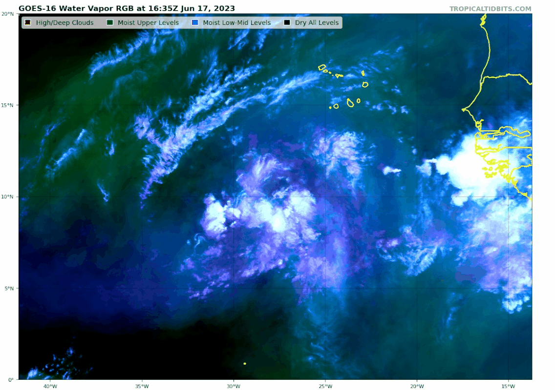
https://twitter.com/TropicalTidbits/status/1670155325461381120
A good breakdown of the spectrum bands used (similar to how the true color imagery is created) - https://rammb.cira.colostate.edu/training/visit/quick_guides/Simple_Water_Vapor_RGB.pdf
https://twitter.com/TropicalTidbits/status/1670155325461381120
A good breakdown of the spectrum bands used (similar to how the true color imagery is created) - https://rammb.cira.colostate.edu/training/visit/quick_guides/Simple_Water_Vapor_RGB.pdf
7 likes
-
cycloneye
- Admin
- Posts: 149719
- Age: 69
- Joined: Thu Oct 10, 2002 10:54 am
- Location: San Juan, Puerto Rico
Re: ATL: INVEST 92L - Discussion
0 likes
Visit the Caribbean-Central America Weather Thread where you can find at first post web cams,radars
and observations from Caribbean basin members Click Here
and observations from Caribbean basin members Click Here
-
USTropics
- Professional-Met
- Posts: 2740
- Joined: Sun Aug 12, 2007 3:45 am
- Location: Florida State University
Re: ATL: INVEST 92L - Discussion
While still a bit elongated, the low-level vorticity has really consolidated this evening. You can follow the full evolution over the past 2 days in the animation below:
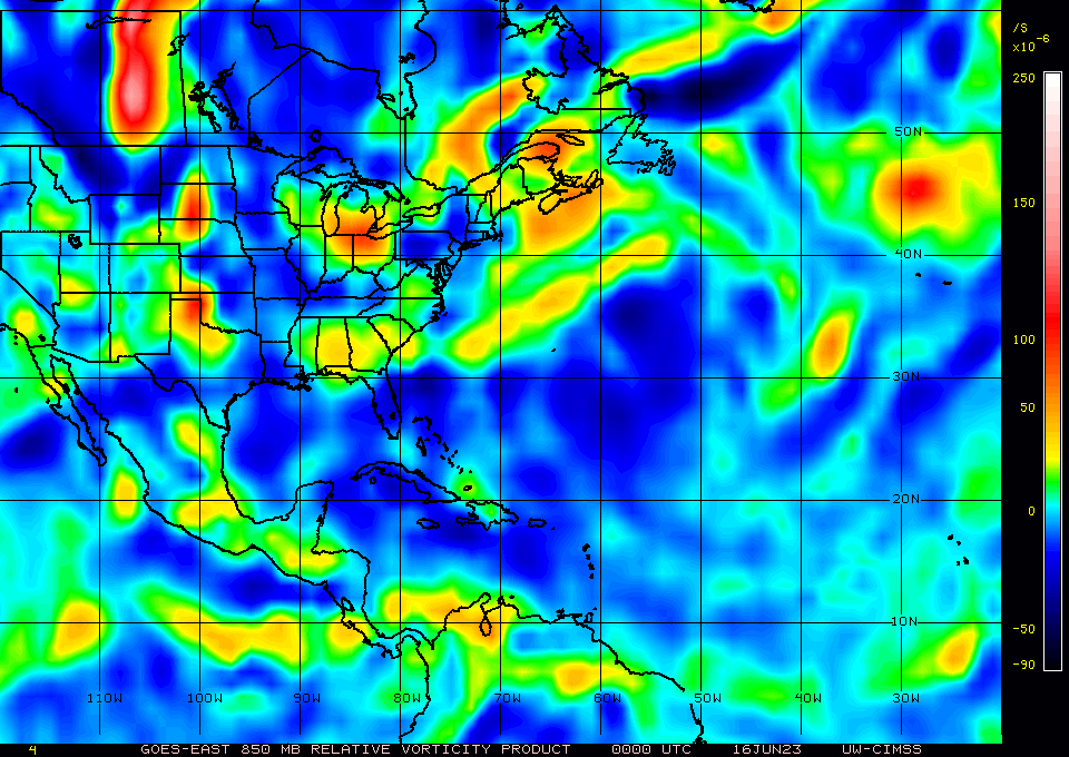
Mid-level vort signature has responded to this as well:

Given improvements in structure, we should see a pulse up in convection as we enter DMAX.
Mid-level vort signature has responded to this as well:
Given improvements in structure, we should see a pulse up in convection as we enter DMAX.
7 likes
-
cycloneye
- Admin
- Posts: 149719
- Age: 69
- Joined: Thu Oct 10, 2002 10:54 am
- Location: San Juan, Puerto Rico
Re: ATL: INVEST 92L - Discussion: 8 PM TWO: 60%/80%
Tropical Weather Outlook
NWS National Hurricane Center Miami FL
800 PM EDT Sat Jun 17 2023
For the North Atlantic...Caribbean Sea and the Gulf of Mexico:
1. Eastern Tropical Atlantic (AL92):
A tropical wave located several hundred miles southwest of the
Cabo Verde Islands is producing a broad area of showers and
thunderstorms. This activity is starting to show some signs of
organization and environmental conditions appear conducive for
additional development. A tropical depression is likely to form by
the early to middle portion of next week while the system moves
westward at 15 to 20 mph across the eastern and central tropical
Atlantic.
* Formation chance through 48 hours...medium...60 percent.
* Formation chance through 7 days...high...80 percent.
Forecaster Papin
0 likes
Visit the Caribbean-Central America Weather Thread where you can find at first post web cams,radars
and observations from Caribbean basin members Click Here
and observations from Caribbean basin members Click Here
-
Sciencerocks
- Category 5
- Posts: 10193
- Age: 40
- Joined: Thu Jul 06, 2017 1:51 am

-
cycloneye
- Admin
- Posts: 149719
- Age: 69
- Joined: Thu Oct 10, 2002 10:54 am
- Location: San Juan, Puerto Rico
Re: ATL: INVEST 92L - Discussion: 8 PM TWO: 60%/80%
The wave looks like it's becoming more convectively active, impressive especially being at DMIN. DMAX may be the trigger.

4 likes
Visit the Caribbean-Central America Weather Thread where you can find at first post web cams,radars
and observations from Caribbean basin members Click Here
and observations from Caribbean basin members Click Here

Re: ATL: INVEST 92L - Discussion
IMHO, chances looking good this gets in the Carib
How far, will depend on a ridge that is forecast to be somewhere over eastern Canada or Great Lakes / New England at that time.
How far, will depend on a ridge that is forecast to be somewhere over eastern Canada or Great Lakes / New England at that time.
1 likes

Re: ATL: INVEST 92L - Discussion
USTropics wrote:While still a bit elongated, the low-level vorticity has really consolidated this evening. You can follow the full evolution over the past 2 days in the animation below:
https://i.postimg.cc/8kRmyMbB/gifmaker-me-10.gif
Mid-level vort signature has responded to this as well:
https://i.imgur.com/X0tS9jJ.png
Given improvements in structure, we should see a pulse up in convection as we enter DMAX.
The consolidation of the 850mb vorticity is pretty much just as the GFS and Euro forecast. I can definitely see genesis by late Monday at the latest now that it’s consolidated.
0 likes
Irene '11 Sandy '12 Hermine '16 5/15/2018 Derecho Fay '20 Isaias '20 Elsa '21 Henri '21 Ida '21
I am only a meteorology enthusiast who knows a decent amount about tropical cyclones. Look to the professional mets, the NHC, or your local weather office for the best information.
I am only a meteorology enthusiast who knows a decent amount about tropical cyclones. Look to the professional mets, the NHC, or your local weather office for the best information.
-
cycloneye
- Admin
- Posts: 149719
- Age: 69
- Joined: Thu Oct 10, 2002 10:54 am
- Location: San Juan, Puerto Rico
Re: ATL: INVEST 92L - Discussion
0 likes
Visit the Caribbean-Central America Weather Thread where you can find at first post web cams,radars
and observations from Caribbean basin members Click Here
and observations from Caribbean basin members Click Here
Who is online
Users browsing this forum: No registered users and 45 guests