EPAC: ADRIAN - Post-Tropical - Discussion
Moderator: S2k Moderators
-
Kingarabian

- S2K Supporter

- Posts: 16379
- Joined: Sat Aug 08, 2009 3:06 am
- Location: Honolulu, Hawaii
-
Astromanía
- Category 2

- Posts: 797
- Age: 27
- Joined: Sat Aug 25, 2018 10:34 pm
- Location: Monterrey, N.L, México
-
ElectricStorm

- Category 5

- Posts: 5155
- Age: 25
- Joined: Tue Aug 13, 2019 11:23 pm
- Location: Norman, OK
Re: EPAC: ADRIAN - Tropical Storm - Discussion
UW - CIMSS
ADVANCED DVORAK TECHNIQUE
ADT-Version 9.1
Tropical Cyclone Intensity Algorithm
----- Current Analysis -----
Date : 27 JUN 2023 Time : 224020 UTC
Lat : 15:18:48 N Lon : 106:15:11 W
CI# /Pressure/ Vmax
2.9 / 999.1mb/ 43.0kt
Final T# Adj T# Raw T#
2.9 3.0 4.2
Center Temp : -62.3C Cloud Region Temp : -63.4C
Scene Type : EMBEDDED CENTER CLOUD REGION
Subtropical Adjustment : OFF
Extratropical Adjustment : OFF
Positioning Method : FORECAST INTERPOLATION
Ocean Basin : EAST PACIFIC
Dvorak CI > MSLP Conversion Used : CKZ Method
Tno/CI Rules : Constraint Limits : 0.2T/hour
Weakening Flag : OFF
Rapid Dissipation Flag : OFF
C/K/Z MSLP Estimate Inputs :
- Average 34 knot radii : 27nmi
- Environmental MSLP : 1008mb
Satellite Name : GOES16
Satellite Viewing Angle : 39.8 degrees
Raw T's shooting up
0 likes
B.S Meteorology, University of Oklahoma '25
Please refer to the NHC, NWS, or SPC for official information.
Please refer to the NHC, NWS, or SPC for official information.

Re: EPAC: ADRIAN - Tropical Storm - Discussion
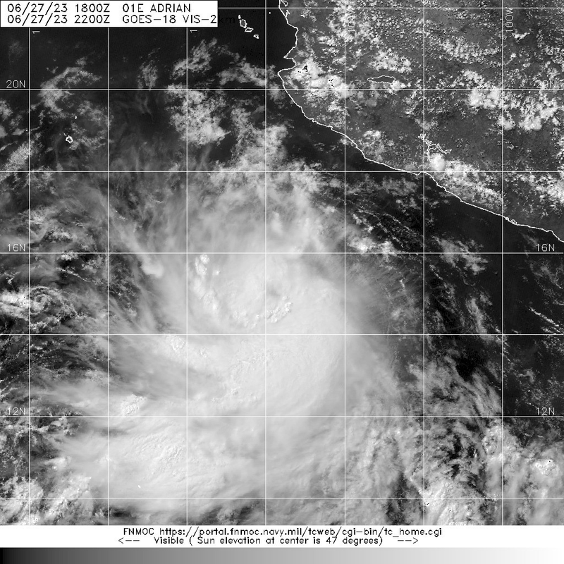
Kingarabian wrote:https://i.postimg.cc/SxzTqLXG/image.png
EPac seems to be trying to make up for lost time. I’m doubtful this will become a major, though.
0 likes
Irene '11 Sandy '12 Hermine '16 5/15/2018 Derecho Fay '20 Isaias '20 Elsa '21 Henri '21 Ida '21
I am only a meteorology enthusiast who knows a decent amount about tropical cyclones. Look to the professional mets, the NHC, or your local weather office for the best information.
I am only a meteorology enthusiast who knows a decent amount about tropical cyclones. Look to the professional mets, the NHC, or your local weather office for the best information.
-
Sciencerocks
- Category 5
- Posts: 10193
- Age: 40
- Joined: Thu Jul 06, 2017 1:51 am

-
wxman57

- Moderator-Pro Met

- Posts: 23175
- Age: 68
- Joined: Sat Jun 21, 2003 8:06 pm
- Location: Houston, TX (southwest)
Re: EPAC: ADRIAN - Tropical Storm - Discussion
Kingarabian wrote:GFS had it becoming a major a few days back but it and the other models have backed off since then. We'll see if it overachieves or not. Looks like it'll be interacting with 92E soon.
Yeah, the GFS is the only model predicting hurricane strength, and you know how it is with overdeveloping all storms. Might make it to hurricane strength, but a major seems unlikely.
1 likes
-
cycloneye

- Admin

- Posts: 149710
- Age: 69
- Joined: Thu Oct 10, 2002 10:54 am
- Location: San Juan, Puerto Rico
Re: EPAC: ADRIAN - Tropical Storm - Discussion
EP, 01, 2023062800, , BEST, 0, 152N, 1064W, 45, 1000, TS
0 likes
Visit the Caribbean-Central America Weather Thread where you can find at first post web cams,radars
and observations from Caribbean basin members Click Here
and observations from Caribbean basin members Click Here
-
Yellow Evan

- Professional-Met

- Posts: 16257
- Age: 27
- Joined: Fri Jul 15, 2011 12:48 pm
- Location: Henderson, Nevada/Honolulu, HI
- Contact:
Re: EPAC: ADRIAN - Tropical Storm - Discussion
TXPZ24 KNES 280023
TCSENP
A. 01E (ADRIAN)
B. 28/0000Z
C. 15.1N
D. 106.2W
E. THREE/GOES-E
F. T3.0/3.0
G. IR/EIR/VIS/AMSR2
H. REMARKS...10/10 BANDING RESULTS IN A DT OF 3.5. 6 HR AVG GIVES A DT
OF 3.2 WHICH JUSTIFIES BREAKING CONSTRAINTS. TIMELY 2326Z GMI PASS SHOWED
SOLID MID-LVL EYE FEATURE AND PARTIAL EYEWALL. UPR-LVL OUTFLOW IMPROVING
AND EXPANDING ALQDS. MET=1.5 AND PT=2.0. FT BASED ON 6 HR AVG DT.
I. ADDL POSITIONS
27/2006Z 15.2N 105.8W AMSR2
...KONON
0 likes
-
Yellow Evan
- Professional-Met
- Posts: 16257
- Age: 27
- Joined: Fri Jul 15, 2011 12:48 pm
- Location: Henderson, Nevada/Honolulu, HI
- Contact:
Re: EPAC: ADRIAN - Tropical Storm - Discussion
* GFS version *
* EAST PACIFIC 2023 SHIPS INTENSITY FORECAST *
* IR SAT DATA AVAILABLE, OHC AVAILABLE *
* ADRIAN EP012023 06/28/23 00 UTC *
TIME (HR) 0 6 12 18 24 36 48 60 72 84 96 108 120 132 144 156 168
V (KT) NO LAND 45 53 62 71 79 91 97 93 80 63 46 35 27 24 21 16 N/A
V (KT) LAND 45 53 62 71 79 91 97 93 80 63 46 35 27 24 21 16 N/A
V (KT) LGEM 45 52 59 66 72 83 91 93 83 67 53 44 38 37 36 34 32
Storm Type TROP TROP TROP TROP TROP TROP TROP TROP TROP TROP TROP TROP TROP TROP TROP TROP TROP
SHEAR (KT) 12 13 8 4 6 10 13 20 31 33 35 21 24 19 16 12 13
SHEAR ADJ (KT) 1 3 1 5 4 -5 2 2 0 -3 -5 5 0 3 0 1 0
SHEAR DIR 11 2 11 358 33 66 82 89 93 96 96 79 71 77 67 101 138
SST (C) 29.0 28.9 28.7 28.6 28.6 28.1 28.0 28.0 27.7 27.4 27.0 26.7 26.5 26.2 25.4 24.5 23.9
POT. INT. (KT) 154 152 150 149 149 144 142 142 138 135 130 127 125 122 114 105 98
200 MB T (C) -50.6 -50.8 -50.9 -50.6 -50.4 -50.9 -50.2 -50.6 -50.4 -51.3 -51.0 -51.6 -51.0 -51.3 -51.0 -51.4 -51.7
200 MB VXT (C) 0.1 0.2 0.5 0.7 0.7 1.1 0.6 0.4 0.3 0.2 0.3 0.6 0.9 0.5 -0.1 -0.1 -0.6
TH_E DEV (C) 8 7 6 5 5 4 3 2 1 1 0 0 0 0 0 0 0
700-500 MB RH 74 76 78 78 76 79 77 76 75 73 74 76 75 74 68 68 65
MODEL VTX (KT) 16 17 22 24 25 28 31 31 29 25 22 19 17 16 16 14 12
850 MB ENV VOR 10 0 -2 4 8 28 46 72 84 93 95 103 99 98 96 95 91
200 MB DIV 75 87 105 101 64 41 49 19 71 34 52 24 12 18 0 -28 -23
700-850 TADV -5 -13 -8 -5 -7 -5 -1 0 -1 -3 -4 -1 0 0 0 -1 -3
LAND (KM) 471 512 550 594 645 761 848 861 880 897 892 856 777 771 812 860 866
LAT (DEG N) 15.2 15.2 15.2 15.3 15.3 15.4 15.5 15.7 15.9 16.1 16.4 16.8 17.4 xx.x xx.x xx.x xx.x
LONG(DEG W) 106.4 107.1 107.8 108.6 109.3 110.8 111.9 113.0 113.9 114.6 115.0 115.0 114.6 xxx.x xxx.x xxx.x xxx.x
STM SPEED (KT) 9 7 7 7 7 6 5 5 4 3 2 3 3 3 4 4 3
HEAT CONTENT 14 12 11 11 12 8 11 14 9 6 4 2 2 0 0 0 0
FORECAST TRACK FROM OFCI INITIAL HEADING/SPEED (DEG/KT):270/ 12 CX,CY: -11/ 0
T-12 MAX WIND: 30 PRESSURE OF STEERING LEVEL (MB): 502 (MEAN=588)
GOES IR BRIGHTNESS TEMP. STD DEV. 50-200 KM RAD: 7.4 (MEAN=14.5)
% GOES IR PIXELS WITH T < -20 C 50-200 KM RAD: 99.0 (MEAN=65.0)
PRELIM RI PROB (DV .GE. 35 KT IN 36 HR): 69.6
INDIVIDUAL CONTRIBUTIONS TO INTENSITY CHANGE
6 12 18 24 36 48 60 72 84 96 108 120 132 144 156 168
--------------------------------------------------------------------------------------------
SAMPLE MEAN CHANGE 0. 1. 1. 1. 1. 2. 2. 1. 1. -0. -1. -1. -2. -3. -3. -4.
SST POTENTIAL 1. 1. 2. 3. 6. 9. 11. 13. 14. 15. 15. 15. 14. 12. 9. 6.
VERTICAL SHEAR MAG 0. 0. 1. 2. 2. 2. 0. -4. -9. -14. -16. -17. -17. -15. -13. -11.
VERTICAL SHEAR ADJ -0. -0. -1. -1. -1. -1. -1. -1. -0. 0. -0. -0. -0. -0. -0. -0.
VERTICAL SHEAR DIR 0. 0. 0. 1. 2. 3. 4. 5. 5. 5. 5. 4. 3. 2. 1. 0.
PERSISTENCE 3. 4. 5. 5. 4. 4. 3. 3. 2. 2. 2. 2. 2. 2. 2. 2.
200/250 MB TEMP. -0. -0. -1. -1. -2. -1. -1. -1. -2. -3. -2. -1. 0. 1. 0. -2.
THETA_E EXCESS 0. 0. 0. 0. -1. -2. -3. -4. -6. -7. -7. -7. -8. -8. -8. -7.
700-500 MB RH 0. 0. 0. 1. 1. 1. 2. 2. 2. 2. 1. 1. 1. 1. 1. 2.
MODEL VTX TENDENCY 0. 3. 5. 7. 9. 14. 18. 17. 12. 7. 3. 0. -0. -1. -3. -4.
850 MB ENV VORTICITY -0. -0. -0. -0. -0. -0. 0. -0. -0. -0. -0. -1. -1. -1. -1. -1.
200 MB DIVERGENCE 0. 0. 1. 1. 1. 1. 1. 2. 2. 2. 1. 1. 0. -0. -0. -0.
850-700 T ADVEC 0. 0. 0. 0. 0. 0. 0. 0. 0. 0. 0. -0. -0. -0. -1. -1.
ZONAL STORM MOTION 0. -0. -0. -0. 0. 0. 0. -0. -0. -0. -0. -0. -1. -1. -1. -2.
STEERING LEVEL PRES -0. -0. -0. -1. -1. -1. -1. -1. -2. -2. -2. -2. -2. -2. -1. -1.
DAYS FROM CLIM. PEAK -0. -0. -0. -0. -0. -0. -0. -1. -1. -2. -2. -2. -3. -3. -4. -4.
GOES PREDICTORS 1. 2. 3. 3. 3. 2. 3. 3. 2. 2. 3. 3. 3. 2. 2. 1.
OCEAN HEAT CONTENT 0. 0. 0. 0. 0. -0. -0. -0. 0. 0. 0. 0. 1. 1. 2. 3.
RI POTENTIAL 2. 5. 9. 13. 21. 19. 11. 2. -3. -7. -11. -13. -13. -12. -12. -11.
--------------------------------------------------------------------------------------------
TOTAL CHANGE 8. 17. 26. 34. 46. 52. 48. 35. 18. 1. -10. -18. -21. -24. -29. -33.
CURRENT MAX WIND (KT): 45. LAT, LON: 15.2 106.4
** 2023 E. PACIFIC RI INDEX EP012023 ADRIAN 06/28/23 00 UTC **
(SHIPS-RII PREDICTOR TABLE for 30 KT OR MORE MAXIMUM WIND INCREASE IN NEXT 24-h)
Predictor Value RI Predictor Range Scaled Value(0-1) % Contribution
POT = MPI-VMAX (KT) : 106.2 36.9 to 148.5 0.62 10.6
12 HR PERSISTENCE (KT) : 15.0 -22.0 to 44.0 0.56 8.2
MULTI-LAYER SHEAR (KT) : 21.7 30.9 to 7.7 0.40 4.6
BL DRY-AIR FLUX (W/M2) : 96.0 816.2 to -81.4 0.80 -10.5
D200 (10**7s-1) : 86.4 -33.0 to 159.5 0.62 6.3
MAXIMUM WIND (KT) : 45.0 22.5 to 132.0 0.64 6.4
STD DEV OF IR BR TEMP : 7.4 37.8 to 2.1 0.85 7.0
HEAT CONTENT (KJ/CM2) : 12.0 2.7 to 103.4 0.09 0.5
%area of TPW <45 mm upshear : 0.0 49.8 to 0.0 1.00 3.1
2nd PC OF IR BR TEMP : -0.9 2.2 to -2.3 0.69 0.1
SHIPS Prob RI for 20kt/ 12hr RI threshold= 19% is 3.0 times climatological mean ( 6.3%)
SHIPS Prob RI for 25kt/ 24hr RI threshold= 53% is 4.2 times climatological mean (12.5%)
SHIPS Prob RI for 30kt/ 24hr RI threshold= 36% is 4.2 times climatological mean ( 8.6%)
SHIPS Prob RI for 35kt/ 24hr RI threshold= 23% is 3.7 times climatological mean ( 6.2%)
SHIPS Prob RI for 40kt/ 24hr RI threshold= 13% is 3.1 times climatological mean ( 4.2%)
SHIPS Prob RI for 45kt/ 36hr RI threshold= 29% is 4.3 times climatological mean ( 6.7%)
SHIPS Prob RI for 55kt/ 48hr RI threshold= 29% is 4.9 times climatological mean ( 5.9%)
SHIPS Prob RI for 65kt/ 72hr RI threshold= 9% is 2.0 times climatological mean ( 4.7%)
Matrix of RI probabilities
------------------------------------------------------------------------------
RI (kt / h) | 20/12 | 25/24 | 30/24 | 35/24 | 40/24 | 45/36 | 55/48 |65/72
------------------------------------------------------------------------------
SHIPS-RII: 18.7% 52.6% 36.2% 23.2% 13.1% 28.9% 29.0% 9.2%
Logistic: 22.5% 59.8% 36.3% 28.7% 6.1% 24.5% 7.6% 3.6%
Bayesian: 14.5% 29.7% 22.9% 15.1% 0.5% 5.2% 1.1% 0.0%
Consensus: 18.6% 47.4% 31.8% 22.3% 6.6% 19.5% 12.5% 4.3%
DTOPS: 34.0% 60.0% 54.0% 29.0% 13.0% 57.0% 36.0% 8.0%
## ANNULAR HURRICANE INDEX (AHI) EP012023 ADRIAN 06/28/23 00 UTC ##
## STORM NOT ANNULAR, SCREENING STEP FAILED, NPASS=4 NFAIL=3 ##
## AHI= 0 (AHI OF 100 IS BEST FIT TO ANN. STRUC., 1 IS MARGINAL, 0 IS NOT ANNULAR) ##
0 likes
-
Sciencerocks
- Category 5
- Posts: 10193
- Age: 40
- Joined: Thu Jul 06, 2017 1:51 am

-
Sciencerocks
- Category 5
- Posts: 10193
- Age: 40
- Joined: Thu Jul 06, 2017 1:51 am

-
Kingarabian
- S2K Supporter
- Posts: 16379
- Joined: Sat Aug 08, 2009 3:06 am
- Location: Honolulu, Hawaii
Re: EPAC: ADRIAN - Tropical Storm - Discussion
T4.0 - T4.5 depending on the fix. Dvorak supports a hurricane but winds especially at this size are likely near 50-60kts.
0 likes
RIP Kobe Bryant
-
cycloneye
- Admin
- Posts: 149710
- Age: 69
- Joined: Thu Oct 10, 2002 10:54 am
- Location: San Juan, Puerto Rico
Re: EPAC: ADRIAN - Tropical Storm - Discussion
BULLETIN
Tropical Storm Adrian Advisory Number 2
NWS National Hurricane Center Miami FL EP012023
900 PM MDT Tue Jun 27 2023
...ADRIAN STRENGTHENING...
...EXPECTED TO BECOME A HURRICANE ON WEDNESDAY...
SUMMARY OF 900 PM MDT...0300 UTC...INFORMATION
----------------------------------------------
LOCATION...15.3N 106.7W
ABOUT 300 MI...485 KM SSW OF MANZANILLO MEXICO
MAXIMUM SUSTAINED WINDS...60 MPH...95 KM/H
PRESENT MOVEMENT...W OR 280 DEGREES AT 12 MPH...19 KM/H
MINIMUM CENTRAL PRESSURE...997 MB...29.44 INCHES
Tropical Storm Adrian Discussion Number 2
NWS National Hurricane Center Miami FL EP012023
900 PM MDT Tue Jun 27 2023
Adrian is getting better organized on satellite imagery, which is
indicative of strengthening. Convective banding is becoming more
defined, primarily over the southern portion of the circulation, and
a CDO feature is starting to develop near/over the center.
Upper-level anticyclonic outflow is becoming established, albeit
slightly restricted to the north of the system. Microwave imagery
shows a mid-level eye-like feature. The current intensity is set at
50 kt, which is a above the subjective Dvorak estimates and close to
the latest objective ADT estimates from UW-CIMSS.
The storm is within an environment of fairly low vertical shear, in
a moist mid-level air mass, and over 28-29 deg C SSTs. Based on
the rapid intensification (RI) indices, i.e. SHIPS-RII and DTOPS,
there is a significant chance of RI during the next day or so. The
official intensity forecast shows, perhaps conservatively, a 25-kt
increase over the next 24 hours. Later in the forecast period, the
numerical guidance indicates some increase in shear and Adrian is
likely to move over somewhat cooler waters which should lead to
gradual weakening. The official forecast is mostly above the
simple and corrected consensus intensity guidance.
The latest center fixes suggest some slowing of the forward speed,
which is now estimated to be 280/10 kt. Over the next few days,
the mid-level ridge to the north of Adrian is forecast to gradually
weaken as it is eroded by a weak trough to the west of Baja
California. This should result in a weakening of the steering
currents and a further decrease in the tropical cyclone's forward
motion. The track model guidance shows a lot of spread near the
end of the forecast period so there is more than usual uncertainty
in the 4- and 5-day forecast locations.
FORECAST POSITIONS AND MAX WINDS
INIT 28/0300Z 15.3N 106.7W 50 KT 60 MPH
12H 28/1200Z 15.3N 108.0W 65 KT 75 MPH
24H 29/0000Z 15.4N 109.4W 75 KT 85 MPH
36H 29/1200Z 15.5N 110.8W 80 KT 90 MPH
48H 30/0000Z 15.6N 112.1W 80 KT 90 MPH
60H 30/1200Z 15.8N 113.3W 80 KT 90 MPH
72H 01/0000Z 16.1N 114.2W 70 KT 80 MPH
96H 02/0000Z 16.6N 115.1W 50 KT 60 MPH
120H 03/0000Z 17.3N 115.7W 35 KT 40 MPH
$$
Forecaster Pasch
0 likes
Visit the Caribbean-Central America Weather Thread where you can find at first post web cams,radars
and observations from Caribbean basin members Click Here
and observations from Caribbean basin members Click Here
-
Yellow Evan
- Professional-Met
- Posts: 16257
- Age: 27
- Joined: Fri Jul 15, 2011 12:48 pm
- Location: Henderson, Nevada/Honolulu, HI
- Contact:
Re: EPAC: ADRIAN - Tropical Storm - Discussion

Nice CB that is expanding upshear and the CDG is rotating a bit. Less bandy structure than earlier will shield Adrian from dry air as well.
0 likes
-
Yellow Evan
- Professional-Met
- Posts: 16257
- Age: 27
- Joined: Fri Jul 15, 2011 12:48 pm
- Location: Henderson, Nevada/Honolulu, HI
- Contact:
Re: EPAC: ADRIAN - Tropical Storm - Discussion
GFS and ECMWF agree that easterly mid-level shear will be an issue tomorrow but subside on Thursday. Assuming this is a hurricane now, it is not unreasonable to suggest after some hiccups tomorrow that Adrian becomes a Category 2 or 3 hurricane thereafter. Its large size will make it vulnerable to dry air intrusions, however.
0 likes
-
Yellow Evan
- Professional-Met
- Posts: 16257
- Age: 27
- Joined: Fri Jul 15, 2011 12:48 pm
- Location: Henderson, Nevada/Honolulu, HI
- Contact:
Re: EPAC: ADRIAN - Tropical Storm - Discussion
TXPZ24 KNES 280628
TCSENP
A. 01E (ADRIAN)
B. 28/0600Z
C. 15.2N
D. 107.3W
E. THREE/GOES-E
F. T3.0/3.0
G. IR/EIR/SWIR/SSMIS
H. REMARKS...10/10 W BANDING RESULTS IN A DT OF 4.0 INCLUDING +0.5 FOR
THE BAND BEING W. THE MET IS 1.5 AND THE PT IS 2.0. THE FT IS BASED ON
THE 6 HOUR AVERAGE DT OF 3.3.
I. ADDL POSITIONS
28/0124Z 15.2N 106.5W SSMIS
...HOSLEY
0 likes
-
Sciencerocks
- Category 5
- Posts: 10193
- Age: 40
- Joined: Thu Jul 06, 2017 1:51 am

-
Sciencerocks
- Category 5
- Posts: 10193
- Age: 40
- Joined: Thu Jul 06, 2017 1:51 am
-
cycloneye
- Admin
- Posts: 149710
- Age: 69
- Joined: Thu Oct 10, 2002 10:54 am
- Location: San Juan, Puerto Rico
Re: EPAC: ADRIAN - Tropical Storm - Discussion
BULLETIN
Tropical Storm Adrian Advisory Number 3
NWS National Hurricane Center Miami FL EP012023
300 AM MDT Wed Jun 28 2023
...ADRIAN CONTINUES TO STRENGTHEN...
...EXPECTED TO BECOME A HURRICANE TODAY...
SUMMARY OF 300 AM MDT...0900 UTC...INFORMATION
----------------------------------------------
LOCATION...15.3N 107.6W
ABOUT 335 MI...540 KM SW OF MANZANILLO MEXICO
MAXIMUM SUSTAINED WINDS...65 MPH...100 KM/H
PRESENT MOVEMENT...W OR 270 DEGREES AT 9 MPH...15 KM/H
MINIMUM CENTRAL PRESSURE...994 MB...29.36 INCHES
Tropical Storm Adrian Discussion Number 3
NWS National Hurricane Center Miami FL EP012023
300 AM MDT Wed Jun 28 2023
Adrian continues to strengthen this morning, with convective banding
becoming well-defined and a CDO developing over the center with
cloud tops of -80C to -90C. In addition, an upper-level
anticyclonic outflow is becoming well established. Subjective
Dvorak estimates were DT 4.0/65-kt from SAB and DT 3.5/55-kt from
TAFB. The latest objective intensity estimates were similar 57 kt
from ADT and 54 kt from SATCON. We also recently received a partial
ASCAT-B, but it likely did not capture the highest winds on the
northeast side of Adrian's circulation. A blend of the subjective
and objective intensity guidance supports an initial intensity of
55 kt for this advisory.
The storm is within a favorable environment with low vertical wind
shear, warm SSTs and a moist air mass. Thus, further strengthening
is expected, with Adrian likely to become a hurricane later today.
Later in the forecast period, guidance indicates some increase in
wind shear in about 3 days, and Adrian is likely to move over
cooler SSTs towards the end of the forecast period. These two
factors should lead to gradual weakening. The official forecast is
mostly above the consensus intensity guidance in the short-term,
given the favorable environment and Adrian's current storm
structure.
The latest center fixes show the cyclone continues to be moving
westward at 270/8 kt. Over the next few days, the mid-level ridge
to the north of Adrian is forecast to gradually weaken as it is
eroded by a weak trough to the west of Baja California. This should
result in a weakening of the steering currents and a decrease in
the tropical cyclone's forward motion. The track model guidance
shows a lot of spread near the end of the forecast period so there
is more than usual uncertainty in the 4- and 5-day forecast
locations.
FORECAST POSITIONS AND MAX WINDS
INIT 28/0900Z 15.3N 107.6W 55 KT 65 MPH
12H 28/1800Z 15.4N 108.9W 65 KT 75 MPH
24H 29/0600Z 15.6N 110.3W 75 KT 85 MPH
36H 29/1800Z 15.8N 111.5W 80 KT 90 MPH
48H 30/0600Z 16.0N 112.7W 80 KT 90 MPH
60H 30/1800Z 16.2N 113.8W 75 KT 85 MPH
72H 01/0600Z 16.6N 114.8W 70 KT 80 MPH
96H 02/0600Z 17.1N 115.9W 50 KT 60 MPH
120H 03/0600Z 17.5N 117.0W 35 KT 40 MPH
$$
Forecaster Kelly/Beven
0 likes
Visit the Caribbean-Central America Weather Thread where you can find at first post web cams,radars
and observations from Caribbean basin members Click Here
and observations from Caribbean basin members Click Here
-
Yellow Evan
- Professional-Met
- Posts: 16257
- Age: 27
- Joined: Fri Jul 15, 2011 12:48 pm
- Location: Henderson, Nevada/Honolulu, HI
- Contact:
Re: EPAC: ADRIAN - Tropical Storm - Discussion
TXPZ24 KNES 281216
TCSENP
A. 01E (ADRIAN)
B. 28/1200Z
C. 15.7N
D. 107.8W
E. THREE/GOES-E
F. T3.0/3.0
G. IR/EIR/SWIR
H. REMARKS...8/10 BANDING RESULTS IN A DT OF 3.5. THE MET IS 2.5 BASED
ON RAPID DEVELOPMENT OVER 24 HOURS. THE PT IS 3.0. THE FT IS BASED ON
THE PT DUE TO THE FLUCTUATING CONVECTION.
I. ADDL POSITIONS
NIL
...BROWN
What on Earth is that rationale to not use FT?
1 likes
Who is online
Users browsing this forum: No registered users and 75 guests