
Big anti-cyclone will develop over a good portion of the Carib starting around Wednesday and will anchor in.
If 90L stays south of Hispaniola, good chance for strong development.
ATL: FRANKLIN - Post-Tropical - Discussion
Moderator: S2k Moderators
Re: ATL: INVEST 90L - Discussion
1 likes
-
cycloneye

- Admin

- Posts: 149720
- Age: 69
- Joined: Thu Oct 10, 2002 10:54 am
- Location: San Juan, Puerto Rico
Re: ATL: INVEST 90L - Discussion
Near the Windward Islands (AL90):
Shower and thunderstorm activity continues in association with an
area of low pressure near the Windward Islands. Some additional
development of this system is likely and a tropical depression could
form by early next week while this system moves westward to
west-northwestward at 10 to 15 mph over the eastern and central
Caribbean Sea. Regardless of development, heavy rainfall is possible
over portions of the Windward Islands during the next couple of
days. Interests in the eastern and central Caribbean should monitor
the progress of this system.
* Formation chance through 48 hours...medium...50 percent.
* Formation chance through 7 days...high...70 percent.
0 likes
Visit the Caribbean-Central America Weather Thread where you can find at first post web cams,radars
and observations from Caribbean basin members Click Here
and observations from Caribbean basin members Click Here
-
cycloneye
- Admin
- Posts: 149720
- Age: 69
- Joined: Thu Oct 10, 2002 10:54 am
- Location: San Juan, Puerto Rico
Re: ATL: INVEST 90L - Discussion
AL, 90, 2023082000, , BEST, 0, 131N, 617W, 25, 1006, LO
0 likes
Visit the Caribbean-Central America Weather Thread where you can find at first post web cams,radars
and observations from Caribbean basin members Click Here
and observations from Caribbean basin members Click Here
-
Blown Away

- S2K Supporter

- Posts: 10253
- Joined: Wed May 26, 2004 6:17 am
Re: ATL: INVEST 90L - Discussion
cycloneye wrote:AL, 90, 2023082000, , BEST, 0, 131N, 617W, 25, 1006, LO
18z 13.0 and 00z early is 13.1, is that keeping up with 18z GFS?
0 likes
Hurricane Eye Experience: David 79, Irene 99, Frances 04, Jeanne 04, Wilma 05… Hurricane Brush Experience: Andrew 92, Erin 95, Floyd 99, Matthew 16, Irma 17, Ian 22, Nicole 22…

Re: ATL: INVEST 90L - Discussion
GCANE wrote:Big anti-cyclone will develop over a good portion of the Carib starting around Wednesday and will anchor in.
If 90L stays south of Hispaniola, good chance for strong development.
All models continue to want to steer 90L into "the rock". Am wondering if this is an issue of the system being initialized as a more vertically deep column then it presently is?
0 likes
Andy D
(For official information, please refer to the NHC and NWS products.)
(For official information, please refer to the NHC and NWS products.)
-
MarioProtVI
- Category 5

- Posts: 1039
- Age: 24
- Joined: Sun Sep 29, 2019 7:33 pm
- Location: New Jersey
Re: ATL: INVEST 90L - Discussion
Looks like this will be Franklin since 98L is gale-force and on the verge of becoming a TC first (thus becoming Emily)
0 likes


Re: ATL: INVEST 90L - Discussion
Makes me wonder if we might see another Emily 1987 out of this system, especially with the track.
0 likes
Georges '98, Irene '99, Frances '04, Jeanne '04, Katrina '05, Wilma '05, Gustav '08, Isaac '12, Matthew '16, Florence '18, Michael '18, Ian '22
-
cycloneye
- Admin
- Posts: 149720
- Age: 69
- Joined: Thu Oct 10, 2002 10:54 am
- Location: San Juan, Puerto Rico
Re: ATL: INVEST 90L - Discussion
Eastern Caribbean (AL90):
Showers and thunderstorms continue to show signs of organization in
association with an area of low pressure over the far eastern
Caribbean Sea. Additional development of this system is expected,
and a tropical depression is likely to form during the next couple
of days as it moves westward to west-northwestward at 10 to 15 mph
over the eastern and central Caribbean, before turning northward and
moving into the southwestern Atlantic Ocean by midweek. Regardless
of development, heavy rainfall is possible over portions of the
Lesser Antilles during the next couple of days. Interests in the
eastern and central Caribbean should monitor the progress of this
system. A NOAA Hurricane Reconnaissance mission is scheduled to
investigate the system later today.
* Formation chance through 48 hours...high...70 percent.
* Formation chance through 7 days...high...80 percent.
1 likes
Visit the Caribbean-Central America Weather Thread where you can find at first post web cams,radars
and observations from Caribbean basin members Click Here
and observations from Caribbean basin members Click Here
-
cycloneye
- Admin
- Posts: 149720
- Age: 69
- Joined: Thu Oct 10, 2002 10:54 am
- Location: San Juan, Puerto Rico
Re: ATL: INVEST 90L - Discussion
AL, 90, 2023082012, , BEST, 0, 140N, 651W, 30, 1004, LO
0 likes
Visit the Caribbean-Central America Weather Thread where you can find at first post web cams,radars
and observations from Caribbean basin members Click Here
and observations from Caribbean basin members Click Here

Re: ATL: INVEST 90L - Discussion
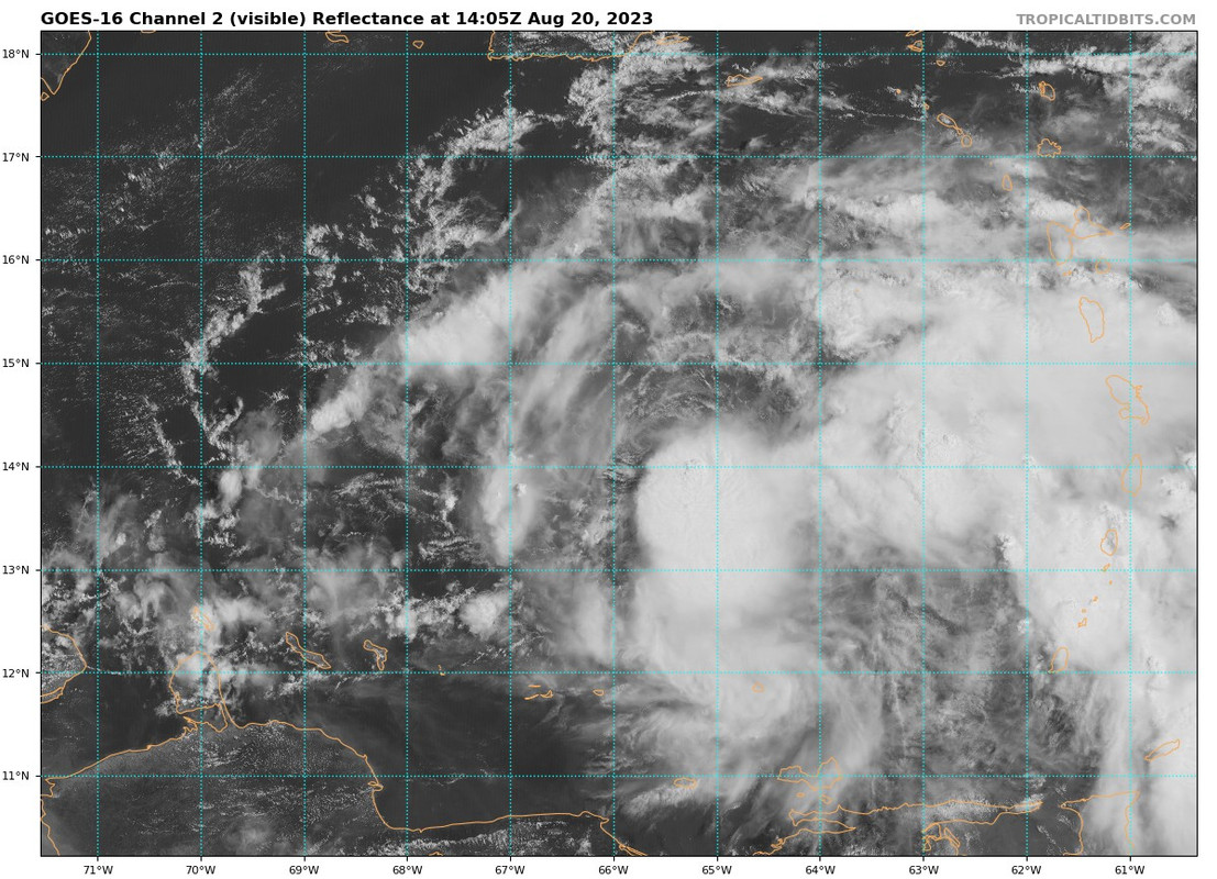
A definite LLC has developed right by the 12z Best Track position.
https://twitter.com/NDGMETCHEF/status/1693246166803099935
https://twitter.com/NDGMETCHEF/status/1693246166803099935
2 likes
-
tolakram
- Admin
- Posts: 20186
- Age: 62
- Joined: Sun Aug 27, 2006 8:23 pm
- Location: Florence, KY (name is Mark)
Re: ATL: INVEST 90L - Discussion
COD regional loop: https://weather.cod.edu/satrad/?parms=regional-prregional-02-24-0-100-1&checked=map&colorbar=undefined
GOES Image Viewer: https://www.star.nesdis.noaa.gov/GOES/sector_band.php?sat=G16§or=car&band=GEOCOLOR&length=24
SLIDER: https://rammb-slider.cira.colostate.edu/?sat=goes-16&sec=full_disk&x=13160&y=7866&z=4&angle=0&im=12&ts=1&st=0&et=0&speed=130&motion=loop&maps%5Bborders%5D=white&p%5B0%5D=geocolor&opacity%5B0%5D=1&pause=0&slider=-1&hide_controls=0&mouse_draw=0&follow_feature=0&follow_hide=0&s=rammb-slider&draw_color=FFD700&draw_width=6
1 likes
M a r k
- - - - -
Join us in chat: Storm2K Chatroom Invite. Android and IOS apps also available.
The posts in this forum are NOT official forecasts and should not be used as such. Posts are NOT endorsed by any professional institution or STORM2K.org. For official information and forecasts, please refer to NHC and NWS products.
-
tolakram
- Admin
- Posts: 20186
- Age: 62
- Joined: Sun Aug 27, 2006 8:23 pm
- Location: Florence, KY (name is Mark)
Re: ATL: INVEST 90L - Discussion
Time sensitive, I think the LLC is right here: https://rammb-slider.cira.colostate.edu/?sat=goes-16&sec=full_disk&x=12883.25&y=7781.25&z=6&angle=0&im=12&ts=1&st=0&et=0&speed=130&motion=loop&maps%5Bborders%5D=white&p%5B0%5D=geocolor&opacity%5B0%5D=1&pause=0&slider=-1&hide_controls=0&mouse_draw=0&follow_feature=0&follow_hide=0&s=rammb-slider&draw_color=FFD700&draw_width=6

2 likes
M a r k
- - - - -
Join us in chat: Storm2K Chatroom Invite. Android and IOS apps also available.
The posts in this forum are NOT official forecasts and should not be used as such. Posts are NOT endorsed by any professional institution or STORM2K.org. For official information and forecasts, please refer to NHC and NWS products.
- - - - -
Join us in chat: Storm2K Chatroom Invite. Android and IOS apps also available.
The posts in this forum are NOT official forecasts and should not be used as such. Posts are NOT endorsed by any professional institution or STORM2K.org. For official information and forecasts, please refer to NHC and NWS products.

Re: ATL: INVEST 90L - Discussion
Naked swirl alert!
1 likes
TC naming lists: retirements and intensity
Most aggressive Advisory #1's in North Atlantic (cr. kevin for starting the list)
Most aggressive Advisory #1's in North Atlantic (cr. kevin for starting the list)
-
Sciencerocks
- Category 5
- Posts: 10193
- Age: 40
- Joined: Thu Jul 06, 2017 1:51 am

-
Blown Away
- S2K Supporter
- Posts: 10253
- Joined: Wed May 26, 2004 6:17 am
Re: ATL: INVEST 90L - Discussion
0 likes
Hurricane Eye Experience: David 79, Irene 99, Frances 04, Jeanne 04, Wilma 05… Hurricane Brush Experience: Andrew 92, Erin 95, Floyd 99, Matthew 16, Irma 17, Ian 22, Nicole 22…
-
Sciencerocks
- Category 5
- Posts: 10193
- Age: 40
- Joined: Thu Jul 06, 2017 1:51 am
Re: ATL: INVEST 90L - Discussion
Looks to be at least a depression. I think this has a decent chance to being tropical storm Franklin and making landfall on the DR with winds of 45-50 knts. Hurricane for the open Atlantic.
1 likes
-
cycloneye
- Admin
- Posts: 149720
- Age: 69
- Joined: Thu Oct 10, 2002 10:54 am
- Location: San Juan, Puerto Rico
Re: ATL: INVEST 90L - Discussion
Eastern Caribbean (AL90):
Showers and thunderstorms continue to show signs of organization in
association with an area of low pressure over the eastern Caribbean
Sea. In addition, visible satellite imagery shows evidence that a
well-defined center is developing, and earlier satellite wind data
indicated the system was producing winds of 35-40 mph. If these
trends continue, a tropical depression or storm could form as soon
as later this afternoon. A NOAA Hurricane Reconnaissance mission is
currently en route to investigate the system this afternoon. The
system is forecast to move westward to west-northwestward at 10 to
15 mph over the eastern and central Caribbean, before turning
northward and potentially affecting the Dominican Republic and Haiti
on Tuesday or Wednesday, where tropical storm watches could become
necessary later this afternoon. Regardless of development, heavy
rainfall is possible over portions of the Lesser Antilles during the
next couple of days. Interests in the eastern and central Caribbean
should monitor the progress of this system.
* Formation chance through 48 hours...high...90 percent.
* Formation chance through 7 days...high...90 percent.
1 likes
Visit the Caribbean-Central America Weather Thread where you can find at first post web cams,radars
and observations from Caribbean basin members Click Here
and observations from Caribbean basin members Click Here

Re: ATL: INVEST 90L - Discussion
90L has a closed low level circulation but is a bit naked hopefully the upper levels will catch up with it.

0 likes
Re: ATL: INVEST 90L - Discussion
Recon finds pressure down to 1000.4. Much stronger than model prediction.
1 likes
Who is online
Users browsing this forum: No registered users and 47 guests