
Despite good model agreement on where landfall may happen, I would still say it's low confidence and will stay low until a clear center forms and that is input into the models.
This morning the NWS Key West mentioned the disturbance for the first time, currently it looks like our impact will be minimal, a little breezy with scattered squalls from outer bands.
ATL: IDALIA - Post-Tropical - Discussion
Moderator: S2k Moderators
Re: ATL: INVEST 93L - Discussion
0 likes
-
cycloneye

- Admin

- Posts: 149703
- Age: 69
- Joined: Thu Oct 10, 2002 10:54 am
- Location: San Juan, Puerto Rico
Re: ATL: INVEST 93L - Discussion
SouthFLTropics wrote:ScottNAtlanta wrote:Looks like an LLC is trying to form around 19N 85W
Definitely some rotation going on under there... I might place it a hair further north but looks like you're looking in the right spot.
12z Best Track had it at 18.0N-85.0W but, the 18z is comming shortly so we will see where they put it.
1 likes
Visit the Caribbean-Central America Weather Thread where you can find at first post web cams,radars
and observations from Caribbean basin members Click Here
and observations from Caribbean basin members Click Here
-
skillz305
- Category 1

- Posts: 312
- Joined: Sat Sep 08, 2018 11:10 am
- Location: Miami, Florida --> Vero Beach, Florida
Re: ATL: INVEST 93L - Discussion
I feel like the CoC is well East of the starting plots. Tricky at this point. As much as we rely on the models support, gotta remember as to where their runs have the starting plot for the disturbance. The entire west coast of FL should be paying attention. Intensity wise? I’ll leave that up to the proMETS. Nice to be back? 
3 likes
 Hurricanes: Andrew 1992 - Irene 1999 - Frances 2004 - Jeanne 2004 - Katrina 2005 - Wilma 2005 - Matthew 2016 - Irma 2017 - Ian 2022 - Nicole 2022 - Milton 2024
Re: ATL: INVEST 93L - Discussion
The most accurate model is the one that best suits your deep, dark meteorological desires. I still like the idea of an out of season Cedar Key slop fest. In a summer of perennial west winds and a near shut out of easterly flow, that track actually IS climo this year
7 likes
-
REDHurricane

- Category 1
- Posts: 438
- Age: 28
- Joined: Sun Jul 03, 2022 2:36 pm
- Location: Northeast Pacific Ocean
-
ConvergenceZone
.gif)
- Category 5

- Posts: 5241
- Joined: Fri Jul 29, 2005 1:40 am
- Location: Northern California
Re: ATL: INVEST 93L - Discussion
ScottNAtlanta wrote:wxman57 wrote:Between EC & GFS looks most likely. NHC would probably start advisories on Monday. Maybe a PTC to start with at 21Z Monday, since it may not be at TD yet and watches would be needed for 48 hrs out.
With the upper high over Bahamas and low in west-central Gulf, should be a sheared storm by Wed pm.
When that ULL to the west moves out this should be right under an anticyclone. The ULL is moving into Mexico at a pretty good clip right now. I don't see there being that much shear in a couple of days
I was thinking the same thing, but remember, our good buddy and fellow wxman57 doesn't enjoy the idea of having to work long hours, and I don't blame him, so he does do lots of -removed-, but it's all in fun.
but back to the topic at hand, I think this can reach minimal hurricane strength if the timing is right. Like other mets have said on here, it all comes down to timing.
0 likes
-
Hurricaneman

- Category 5
- Posts: 7404
- Age: 45
- Joined: Tue Aug 31, 2004 3:24 pm
- Location: central florida
Re: ATL: INVEST 93L - Discussion
REDHurricane wrote:LLC trying to set up somewhere in this general area?
https://media3.giphy.com/media/v1.Y2lkPTc5MGI3NjExMTlmc3lxOGV0dnVxMTRraW1zazEwdHI0Mm1zcWN1dTZzNWo5Znc0dCZlcD12MV9pbnRlcm5hbF9naWZfYnlfaWQmY3Q9Zw/sjOJIZm2fe3eLJFfJo/giphy.gif
If it sets up there then we may have a system that doesn’t landfall in the Yucatán which means a stronger system for Florida
0 likes
-
wxman57

- Moderator-Pro Met

- Posts: 23175
- Age: 68
- Joined: Sat Jun 21, 2003 8:06 pm
- Location: Houston, TX (southwest)
Re: ATL: INVEST 93L - Discussion
REDHurricane wrote:LLC trying to set up somewhere in this general area?
https://media3.giphy.com/media/v1.Y2lkPTc5MGI3NjExMTlmc3lxOGV0dnVxMTRraW1zazEwdHI0Mm1zcWN1dTZzNWo5Znc0dCZlcD12MV9pbnRlcm5hbF9naWZfYnlfaWQmY3Q9Zw/sjOJIZm2fe3eLJFfJo/giphy.gif
No west of your red circle. Closer to the coast of the Yucatan. It'll likely hang around Cancun/Cozumel this weekend.
0 likes
-
Stormcenter
- S2K Supporter

- Posts: 6689
- Joined: Wed Sep 03, 2003 11:27 am
- Location: Houston, TX
Re: ATL: INVEST 93L - Discussion
Too funny and very true.
psyclone wrote:The most accurate model is the one that best suits your deep, dark meteorological desires. I still like the idea of an out of season Cedar Key slop fest. In a summer of perennial west winds and a near shut out of easterly flow, that track actually IS climo this year
0 likes
-
ScottNAtlanta

- Category 5
- Posts: 2535
- Joined: Sat May 25, 2013 3:11 pm
- Location: Atlanta, GA
Re: ATL: INVEST 93L - Discussion
I think that what needs to be considered is when this does become a classified system, how organized is it, and is it still under an anticyclone. If this thing forms an organized depression and not a sloppy mess, it is going to RI. The water is way to warm for it not to if the other dynamics are there. Look at all the other systems in this area that have formed and put into context that the water is about 2 C warmer than any of those events. Something to pay attention to.
1 likes
The posts in this forum are NOT official forecast and should not be used as such. They are just the opinion of the poster and may or may not be backed by sound meteorological data. They are NOT endorsed by any professional institution or storm2k.org. For official information, please refer to the NHC and NWS products.
-
toad strangler

- S2K Supporter
- Posts: 4546
- Joined: Sun Jul 28, 2013 3:09 pm
- Location: Earth
- Contact:
Re: ATL: INVEST 93L - Discussion
ScottNAtlanta wrote:I think that what needs to be considered is when this does become a classified system, how organized is it, and is it still under an anticyclone. If this thing forms an organized depression and not a sloppy mess, it is going to RI. The water is way to warm for it not to if the other dynamics are there. Look at all the other systems in this area that have formed and put into context that the water is about 2 C warmer than any of those events. Something to pay attention to.
We are in that special little zone of 8/20 to 9/9. The barely 3 week stretch in ramp up to peak season. Ya, so I wouldn't be surprised if some tropical trickery regarding intensity is at hand at some point.
Last edited by toad strangler on Fri Aug 25, 2023 1:58 pm, edited 2 times in total.
0 likes
My Weather Station
https://www.wunderground.com/dashboard/pws/KFLPORTS603
https://www.wunderground.com/dashboard/pws/KFLPORTS603
Re: ATL: INVEST 93L - Discussion
skillz305 wrote:I feel like the CoC is well East of the starting plots. Tricky at this point. As much as we rely on the models support, gotta remember as to where their runs have the starting plot for the disturbance. The entire west coast of FL should be paying attention. Intensity wise? I’ll leave that up to the proMETS. Nice to be back?
For sure. If this forms further east then I would expect the models/forecast to shift to the right.
One trend today is more northward and less east. We will see if that trend continues or if the models will do the windshield wiper until we get a well defined system.
1 likes
-
cycloneye
- Admin
- Posts: 149703
- Age: 69
- Joined: Thu Oct 10, 2002 10:54 am
- Location: San Juan, Puerto Rico
Re: ATL: INVEST 93L - Discussion
18z Best Track for those who wanted to know the new position.

AL, 93, 2023082518, , BEST, 0, 19.0N, 85.5W, 20, 1008, LO
0 likes
Visit the Caribbean-Central America Weather Thread where you can find at first post web cams,radars
and observations from Caribbean basin members Click Here
and observations from Caribbean basin members Click Here
-
REDHurricane
- Category 1
- Posts: 438
- Age: 28
- Joined: Sun Jul 03, 2022 2:36 pm
- Location: Northeast Pacific Ocean
Re: ATL: INVEST 93L - Discussion
wxman57 wrote: No west of your red circle. Closer to the coast of the Yucatan. It'll likely hang around Cancun/Cozumel this weekend.
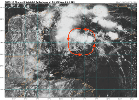
I'll trust your expertise, but to me it looks like there's a definite low-level swirl centered at 84ºW and moving north from around 18-19ºN in this gif -- maybe I'm seeing something else? Still trying to get better at analyzing these things
0 likes
-
typhoonty
- Tropical Storm

- Posts: 121
- Age: 31
- Joined: Wed May 31, 2017 10:37 pm
- Location: Fort Myers / Tallahassee, FL
- Contact:
Re: ATL: INVEST 93L - Discussion
cycloneye wrote:18z Best Track for those who wanted to know the new position.AL, 93, 2023082518, , BEST, 0, 19.0N, 85.5W, 20, 1008, LO
https://i.imgur.com/WZydqhK.png
If we treated this as god, 12Z Euro is significantly closer to reality than 12Z GFS at T+6.
2 likes
FSU Meteorology student, opinions are mine, 20 years experience covering TC's, consult NHC/Local officials when making decisions.
Gabrielle '01, Michelle '01, Charley '04, Frances '04, Dennis '05, Katrina '05, Rita '05, Wilma '05, Fay '08, Isaac '12 Hermine '16, Irma '17, Michael '18, Eta '20, Elsa '21, IAN '22, Idalia '23, Debby '24, Helene '24
Gabrielle '01, Michelle '01, Charley '04, Frances '04, Dennis '05, Katrina '05, Rita '05, Wilma '05, Fay '08, Isaac '12 Hermine '16, Irma '17, Michael '18, Eta '20, Elsa '21, IAN '22, Idalia '23, Debby '24, Helene '24

Re: ATL: INVEST 93L - Discussion
typhoonty wrote:cycloneye wrote:18z Best Track for those who wanted to know the new position.AL, 93, 2023082518, , BEST, 0, 19.0N, 85.5W, 20, 1008, LO
https://i.imgur.com/WZydqhK.png
If we treated this as god, 12Z Euro is significantly closer to reality than 12Z GFS at T+6.
I can't help thinking that the huge ridge over Oklahoma/Texas has to have an affect pulling this storm more towards the north and
northwest. It isn't supposed to move back west for a few days yet and our temps don't indicate it is moving much in the near term.
0 likes
-
wxman57
- Moderator-Pro Met
- Posts: 23175
- Age: 68
- Joined: Sat Jun 21, 2003 8:06 pm
- Location: Houston, TX (southwest)
Re: ATL: INVEST 93L - Discussion
I still see an upper trof to its west in the NE Gulf with SW wind shear across the top Tuesday night/Wed. No anticyclone over it.
0 likes
-
wxman57
- Moderator-Pro Met
- Posts: 23175
- Age: 68
- Joined: Sat Jun 21, 2003 8:06 pm
- Location: Houston, TX (southwest)
Re: ATL: INVEST 93L - Discussion
hipshot wrote:I can't help thinking that the huge ridge over Oklahoma/Texas has to have an affect pulling this storm more towards the north and
northwest. It isn't supposed to move back west for a few days yet and our temps don't indicate it is moving much in the near term.
If the ridge stays firm, it goes farther east, not west. Ridges don't pull a storm toward them.
0 likes
-
cycloneye
- Admin
- Posts: 149703
- Age: 69
- Joined: Thu Oct 10, 2002 10:54 am
- Location: San Juan, Puerto Rico
Re: ATL: INVEST 93L - Discussion
Here is the 18z plot of the best track that has it at 19.0N-85.5W.

1 likes
Visit the Caribbean-Central America Weather Thread where you can find at first post web cams,radars
and observations from Caribbean basin members Click Here
and observations from Caribbean basin members Click Here

Re: ATL: INVEST 93L - Discussion
wxman57 wrote:I still see an upper trof to its west in the NE Gulf with SW wind shear across the top Tuesday night/Wed. No anticyclone over it.
Hopefully you're right 57, we definitely don't need to lose yet another I name!
0 likes
Georges '98, Irene '99, Frances '04, Jeanne '04, Katrina '05, Wilma '05, Gustav '08, Isaac '12, Matthew '16, Florence '18, Michael '18, Ian '22
Who is online
Users browsing this forum: No registered users and 61 guests