ATL: RINA - Remnants - Discussion
Moderator: S2k Moderators

Re: ATL: INVEST 91L - Discussion
Hard to believe that a storm this far south in September isn't a threat to the islands.
3 likes
-
cycloneye

- Admin

- Posts: 149696
- Age: 69
- Joined: Thu Oct 10, 2002 10:54 am
- Location: San Juan, Puerto Rico
Re: ATL: INVEST 91L - Discussion
Let's do a quick sample here about how much ACE future Rina will get. First the two hurricanes that have got more this season are Franklin with 26.6 and Lee with 36.8. Margot got 12.7 and Nigel had 10.5.
My guess is 20.4.
Ok peeps, Go ahead with your numbers.
My guess is 20.4.
Ok peeps, Go ahead with your numbers.
1 likes
Visit the Caribbean-Central America Weather Thread where you can find at first post web cams,radars
and observations from Caribbean basin members Click Here
and observations from Caribbean basin members Click Here
-
Sciencerocks
- Category 5

- Posts: 10193
- Age: 40
- Joined: Thu Jul 06, 2017 1:51 am
-
Sciencerocks
- Category 5
- Posts: 10193
- Age: 40
- Joined: Thu Jul 06, 2017 1:51 am
Re: ATL: INVEST 91L - Discussion
cycloneye wrote:Let's do a quick sample here about how much ACE future Rina will get. First the two hurricanes that have got more this season are Franklin with 26.6 and Lee with 36.8. Margot got 12.7 and Nigel had 10.5.
My guess is 20.4.The posts in this forum are NOT official forecasts and should not be used as such. They are just the opinion of the poster and may or may not be backed by sound meteorological data. They are NOT endorsed by any professional institution or STORM2K. For official information, please refer to products from the NHC and NWS.
~14.5. I believe I'll be a hurricane in the western Atlantic and move west of bermuda in about 8-10 days but no more then a cat1-low end 2 at tops.2 likes
-
Hurricane2022

- Category 5
- Posts: 2092
- Joined: Tue Aug 23, 2022 11:38 pm
- Location: Araçatuba, Brazil
Re: ATL: INVEST 91L - Discussion
cycloneye wrote:Let's do a quick sample here about how much ACE future Rina will get. First the two hurricanes that have got more this season are Franklin with 26.6 and Lee with 36.8. Margot got 12.7 and Nigel had 10.5.
My guess is 20.4.
Ok peeps, Go ahead with your numbers.
16.3 - 25.9 Points of ACE. Peak winds will be around 120 - 145 mph.
0 likes
Sorry for the bad English sometimes...!
For reliable and detailed information for any meteorological phenomenon, please consult the National Hurricane Center, Joint Typhoon Warning Center , or your local Meteo Center.
--------
ECCE OMNIA NOVA FACIAM (Ap 21,5).
For reliable and detailed information for any meteorological phenomenon, please consult the National Hurricane Center, Joint Typhoon Warning Center , or your local Meteo Center.
--------
ECCE OMNIA NOVA FACIAM (Ap 21,5).
-
cycloneye
- Admin
- Posts: 149696
- Age: 69
- Joined: Thu Oct 10, 2002 10:54 am
- Location: San Juan, Puerto Rico
Re: ATL: INVEST 91L - Discussion
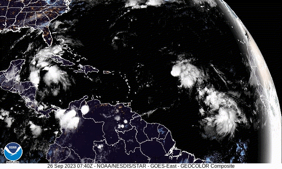
2 PM TWO:
Central Tropical Atlantic (AL91):
Showers and thunderstorms continue to show signs of organization in
association with a broad area of low pressure located several
hundred miles west-southwest of the Cabo Verde Islands.
Environmental conditions are forecast to be conducive for
development, and a tropical depression is expected to form in the
next day or two while the system moves west-northwestward across the
central tropical Atlantic.
* Formation chance through 48 hours...high...80 percent.
* Formation chance through 7 days...high...90 percent.
0 likes
Visit the Caribbean-Central America Weather Thread where you can find at first post web cams,radars
and observations from Caribbean basin members Click Here
and observations from Caribbean basin members Click Here
-
KirbyDude25

- Tropical Storm

- Posts: 162
- Age: 21
- Joined: Mon Sep 20, 2021 8:03 am
- Location: Westfield, New Jersey
Re: ATL: INVEST 91L - Discussion
cycloneye wrote:Let's do a quick sample here about how much ACE future Rina will get. First the two hurricanes that have got more this season are Franklin with 26.6 and Lee with 36.8. Margot got 12.7 and Nigel had 10.5.
My guess is 20.4.
Ok peeps, Go ahead with your numbers.
I would guess more ACE than Margot, but less than Franklin. Somewhere around 18-20 ACE, peaking at around the same intensity as Nigel but with a longer lifespan.
0 likes
New Jersey, Rutgers '27
Irene 2011 | Sandy 2012 | Fay 2020 | Isaias 2020 | Ida 2021
Irene 2011 | Sandy 2012 | Fay 2020 | Isaias 2020 | Ida 2021
-
Iceresistance

- Category 5
- Posts: 9605
- Age: 22
- Joined: Sat Oct 10, 2020 9:45 am
- Location: Tecumseh, OK/Norman, OK
Re: ATL: INVEST 91L - Discussion
cycloneye wrote:Let's do a quick sample here about how much ACE future Rina will get. First the two hurricanes that have got more this season are Franklin with 26.6 and Lee with 36.8. Margot got 12.7 and Nigel had 10.5.
My guess is 20.4.
Ok peeps, Go ahead with your numbers.
Difficult forecast because of interaction with Philippe, once the forecast becomes clearer, I can post my ACE guess
4 likes
Bill 2015 & Beta 2020
Winter 2020-2021
All observations are in Tecumseh, OK unless otherwise noted.
Winter posts are focused mainly for Oklahoma & Texas.
Take any of my forecasts with a grain of salt, refer to the NWS, SPC, and NHC for official information
Never say Never with weather! Because ANYTHING is possible!
Winter 2020-2021
All observations are in Tecumseh, OK unless otherwise noted.
Winter posts are focused mainly for Oklahoma & Texas.
Take any of my forecasts with a grain of salt, refer to the NWS, SPC, and NHC for official information
Never say Never with weather! Because ANYTHING is possible!
-
ElectricStorm

- Category 5
- Posts: 5153
- Age: 25
- Joined: Tue Aug 13, 2019 11:23 pm
- Location: Norman, OK
Re: ATL: INVEST 91L - Discussion
I'll go with about 15 ACE. 80-90kt peak
0 likes
B.S Meteorology, University of Oklahoma '25
Please refer to the NHC, NWS, or SPC for official information.
Please refer to the NHC, NWS, or SPC for official information.
-
WalterWhite

- Category 1

- Posts: 342
- Joined: Fri Mar 17, 2023 5:53 pm

Re: ATL: INVEST 91L - Discussion
Maybe 75-90 kt and 10-15 ACE, and that could be too high. It’s very possible 91L ends up as just another repeat of Phillippe.
1 likes
Irene '11 Sandy '12 Hermine '16 5/15/2018 Derecho Fay '20 Isaias '20 Elsa '21 Henri '21 Ida '21
I am only a meteorology enthusiast who knows a decent amount about tropical cyclones. Look to the professional mets, the NHC, or your local weather office for the best information.
I am only a meteorology enthusiast who knows a decent amount about tropical cyclones. Look to the professional mets, the NHC, or your local weather office for the best information.
-
cycloneye
- Admin
- Posts: 149696
- Age: 69
- Joined: Thu Oct 10, 2002 10:54 am
- Location: San Juan, Puerto Rico
Re: ATL: INVEST 91L - Discussion
AL, 91, 2023092618, , BEST, 0, 112N, 392W, 30, 1008, DB

1 likes
Visit the Caribbean-Central America Weather Thread where you can find at first post web cams,radars
and observations from Caribbean basin members Click Here
and observations from Caribbean basin members Click Here
-
wxman57

- Moderator-Pro Met

- Posts: 23175
- Age: 68
- Joined: Sat Jun 21, 2003 8:06 pm
- Location: Houston, TX (southwest)
Re: ATL: INVEST 91L - Discussion
Models were forecasting Philippe to be a long-lasting and intense hurricane. Well, that didn't happen. Will this one have the same fate? There just isn't any high pressure to its north to move it west through the Caribbean. Season appears to be winding down. Still have to watch the NW Caribbean for any late-season Florida mischief.
9 likes
-
Sciencerocks
- Category 5
- Posts: 10193
- Age: 40
- Joined: Thu Jul 06, 2017 1:51 am
Re: ATL: INVEST 91L - Discussion

I'll say 75knt peak, 14.5 ace and will get to 68 west before recurving. Will last about 8-9 days as a tropical cyclone...
0 likes
-
WalterWhite
- Category 1
- Posts: 342
- Joined: Fri Mar 17, 2023 5:53 pm
Re: ATL: INVEST 91L - Discussion
wxman57 wrote:Models were forecasting Philippe to be a long-lasting and intense hurricane. Well, that didn't happen. Will this one have the same fate? There just isn't any high pressure to its north to move it west through the Caribbean. Season appears to be winding down. Still have to watch the NW Caribbean for any late-season Florida mischief.
Just because the models busted Phillipe does not necessarily mean they will bust 91L.
1 likes
Re: ATL: INVEST 91L - Discussion
WalterWhite wrote:wxman57 wrote:Models were forecasting Philippe to be a long-lasting and intense hurricane. Well, that didn't happen. Will this one have the same fate? There just isn't any high pressure to its north to move it west through the Caribbean. Season appears to be winding down. Still have to watch the NW Caribbean for any late-season Florida mischief.
Just because the models busted Phillipe does not necessarily mean they will bust 91L.
91L will be facing shear, just like Phillipe. It’s up in the air (no pun intended) whether it’ll also bust, or if it’ll manage to pull through and find better luck past 5 days
0 likes
Irene '11 Sandy '12 Hermine '16 5/15/2018 Derecho Fay '20 Isaias '20 Elsa '21 Henri '21 Ida '21
I am only a meteorology enthusiast who knows a decent amount about tropical cyclones. Look to the professional mets, the NHC, or your local weather office for the best information.
I am only a meteorology enthusiast who knows a decent amount about tropical cyclones. Look to the professional mets, the NHC, or your local weather office for the best information.
Re: ATL: INVEST 91L - Discussion
wxman57 wrote:Models were forecasting Philippe to be a long-lasting and intense hurricane. Well, that didn't happen. Will this one have the same fate? There just isn't any high pressure to its north to move it west through the Caribbean. Season appears to be winding down. Still have to watch the NW Caribbean for any late-season Florida mischief.
I know this is the wrong thread, but do you see a big system forming in the Caribbean in Oct? The Canadian end of the run shows a storm forming. Can you tell us your thoughts for Oct and Nov in another thread? Also with the warm Caribbean and Gulf do you see any Nov Gulf threats?
1 likes
-
cycloneye
- Admin
- Posts: 149696
- Age: 69
- Joined: Thu Oct 10, 2002 10:54 am
- Location: San Juan, Puerto Rico
Re: ATL: INVEST 91L - Discussion
Central Tropical Atlantic (AL91):
Showers and thunderstorms continue to become better organized in
association with an area of low pressure located roughly halfway
between the Cabo Verde Islands and the Lesser Antilles.
Environmental conditions are forecast to be conducive for
development, and a tropical depression or storm is expected to form
in the next day or so while the system moves west-northwestward
across the central tropical Atlantic. Additional information on this
system, including gale warnings, can be found in High Seas Forecasts
issued by the National Weather Service.
* Formation chance through 48 hours...high...90 percent.
* Formation chance through 7 days...high...90 percent.
1 likes
Visit the Caribbean-Central America Weather Thread where you can find at first post web cams,radars
and observations from Caribbean basin members Click Here
and observations from Caribbean basin members Click Here
-
Sciencerocks
- Category 5
- Posts: 10193
- Age: 40
- Joined: Thu Jul 06, 2017 1:51 am

-
Yellow Evan

- Professional-Met

- Posts: 16257
- Age: 27
- Joined: Fri Jul 15, 2011 12:48 pm
- Location: Henderson, Nevada/Honolulu, HI
- Contact:
Re: ATL: INVEST 91L - Discussion Update: TWO 8 PM=90%/90% / TD or TS may form in next 24 hours
Upper environment should keep this in check for at least 5 days. Afterwards harder to say but large size will also make significant strengthening harder to come by.
1 likes
Who is online
Users browsing this forum: No registered users and 59 guests