Honestly, there are so many factors in play that it's impossible to guess exactly where this storm is actually going to end up. With all potential recurve possibilities being roughly 7+ days out, the pattern is probably not going to be exactly the same then as it's currently showing up on models.
Levi Cowan mentioned on a video he just posted that a subtropical jet has been consistently shown in the southeast around the 5 day mark, making landfall in the southeast (Florida, Georgia, maybe South Carolina) more unlikely, but it's still not a sure shot given we're still over a week away from Lee possibly making his recurve. When and where Lee begins to recurve will be key.
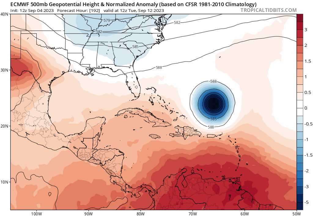
Compare the 12z and 06z runs of the GFS for example. Note how even just a run apart, the two upper-level ridges above/near the trough that's supposed to help turn Lee to the north/northeast keep flip-flopping between choking out the trough from the north after Lee turns northward (therefore having a high-pressure ridge being above Lee the whole time during his northward trek) and having the trough end up sandwiched between a high pressure ridge to the northeast and the high pressure ridge to the northwest, which may give Lee more of a weakness to pull into.
The good news is that we do have a pretty good idea of Lee's short-term movement. A west-northwest motion seems to be generally agreed on by most of the models for the next few days. Barring any extreme changes or a more westward-than-forecast movement, this will hopefully mean that the Caribbean islands will be south of Lee's core and most if not all of the winds.
ATL: LEE - Models
Moderator: S2k Moderators
-
ThunderForce

- Tropical Storm

- Posts: 208
- Age: 26
- Joined: Tue Sep 27, 2022 6:20 pm
- Location: Calhoun County, Florida
Re: ATL: LEE - Models
Last edited by ThunderForce on Wed Sep 06, 2023 1:35 pm, edited 2 times in total.
4 likes
Please refer to the NWS, NHC, SPC or a professional meteorologist for information and decision making during storms.

-
RevanTheJedi96
- Tropical Storm
- Posts: 106
- Joined: Wed Sep 01, 2021 10:40 am
Re: ATL: LEE - Models
I have seen so many potential New England hurricanes that always end in near misses or the storm loses steam. This one, if it were to materialize, would be catastrophic to the region so I would very much like this trend to continue. One day though, it won't.
1 likes
Re: ATL: LEE - Models
The 12Z Euro at 132 is ~150 miles SSE of the 0Z at 144 and isn't quite as strong though it is still a beast.
1 likes
Personal Forecast Disclaimer:
The posts in this forum are NOT official forecasts and should not be used as such. They are just the opinion of the poster and may or may not be backed by sound meteorological data. They are NOT endorsed by any professional institution or storm2k.org. For official information, please refer to the NHC and NWS products.
The posts in this forum are NOT official forecasts and should not be used as such. They are just the opinion of the poster and may or may not be backed by sound meteorological data. They are NOT endorsed by any professional institution or storm2k.org. For official information, please refer to the NHC and NWS products.
-
Blown Away

- S2K Supporter

- Posts: 10253
- Joined: Wed May 26, 2004 6:17 am
Re: ATL: LEE - Models
LarryWx wrote:The 12Z Euro at 132 is ~150 miles SSE of the 0Z at 144 and isn't quite as strong though it is still a beast.
12z Euro... Models slowing Lee down and delaying N turn?
7 likes
Hurricane Eye Experience: David 79, Irene 99, Frances 04, Jeanne 04, Wilma 05… Hurricane Brush Experience: Andrew 92, Erin 95, Floyd 99, Matthew 16, Irma 17, Ian 22, Nicole 22…
-
Spacecoast

- Category 2

- Posts: 773
- Joined: Thu Aug 31, 2017 2:03 pm
Re: RE: Re: ATL: LEE - Models
Woofde wrote:I'm not gonna say it's likely a SE storm, because that's not a favored pattern. That said just look at the GFS 7 days out. Models become unskilled fast past this point. I don't think it's reasonable to rule out the Southeast just yet. There's good reason the NHC cone only goes out 5 days.
Models do become unskilled past 2 days, more unskilled past 5 days, and even more unskilled past 7 days. That does not make 7 day models useless.
It's just a matter of quantifying the skill, (or track error) at each of these forecast points. Verification data is available.
At 7 days, I like to draw a 500-700nm circle around the forecast point, basically creating a 7 day cone. (Hint: TT models have a measurement tool by holding 'SHIFT').
Example:
Here are the track errors for Franklin 1 day to 7.5 days...

In this case, the CMC did fairly well @450 nm, while the UKMET (EGRR) had ~700nm error.
Last edited by Spacecoast on Wed Sep 06, 2023 1:54 pm, edited 3 times in total.
4 likes
-
ThunderForce
- Tropical Storm
- Posts: 208
- Age: 26
- Joined: Tue Sep 27, 2022 6:20 pm
- Location: Calhoun County, Florida
Re: ATL: LEE - Models
Blown Away wrote:LarryWx wrote:The 12Z Euro at 132 is ~150 miles SSE of the 0Z at 144 and isn't quite as strong though it is still a beast.
[url]https://i.postimg.cc/1X5dMgvL/9ddbda3e-f372-4bfd-998e-d7a4417dd0c2.gif [/url]
12z Euro... Models slowing Lee down and delaying N turn?
I'm not 100% sure given I'm not a meteorologist, but it appears that Lee is slowing down on the latest model runs due to a Fujiwhara effect with a developing storm to Lee's east (possibly future Margot) that was originally weaker in previous runs.
0 likes
Please refer to the NWS, NHC, SPC or a professional meteorologist for information and decision making during storms.
-
AutoPenalti
- Category 5

- Posts: 4091
- Age: 29
- Joined: Mon Aug 17, 2015 4:16 pm
- Location: Ft. Lauderdale, Florida
Re: ATL: LEE - Models
Seems like this is further South but looks like it may find a way north.
1 likes
The posts in this forum are NOT official forecasts and should not be used as such. They are just the opinion of the poster and may or may not be backed by sound meteorological data. They are NOT endorsed by any professional institution or STORM2K. For official information, please refer to products from the NHC and NWS.
Model Runs Cheat Sheet:
GFS (5:30 AM/PM, 11:30 AM/PM)
HWRF, GFDL, UKMET, NAVGEM (6:30-8:00 AM/PM, 12:30-2:00 AM/PM)
ECMWF (1:45 AM/PM)
TCVN is a weighted averaged
-
Blown Away
- S2K Supporter
- Posts: 10253
- Joined: Wed May 26, 2004 6:17 am
Re: ATL: LEE - Models
AutoPenalti wrote:Seems like this is further South but looks like it may find a way north.
Something is going to give, Lee is nearing 50W and going to be off Carolinas in 10 days???
1 likes
Hurricane Eye Experience: David 79, Irene 99, Frances 04, Jeanne 04, Wilma 05… Hurricane Brush Experience: Andrew 92, Erin 95, Floyd 99, Matthew 16, Irma 17, Ian 22, Nicole 22…
-
AxaltaRacing24
- Category 5
- Posts: 1774
- Age: 25
- Joined: Wed Jul 27, 2016 11:14 am
- Location: Jupiter, FL
Re: ATL: LEE - Models
Blown Away wrote:AutoPenalti wrote:Seems like this is further South but looks like it may find a way north.
Something is going to give, Lee is nearing 50W and going to be off Carolinas in 10 days???
The longer it takes to get up there, it opens the door to a larger error and new scenarios.
1 likes
Re: ATL: LEE - Models
12z euro is nearly the same as the GFS on track, just takes longer getting there. Pretty good agreement so far to split the gap between Bermuda and the East coast. Hope that continues. Beyond the euro run is a bit different though. Still a lot of time to watch it.
Last edited by BobHarlem on Wed Sep 06, 2023 2:11 pm, edited 3 times in total.
1 likes
-
cheezyWXguy

- Category 5
- Posts: 6280
- Joined: Mon Feb 13, 2006 12:29 am
- Location: Dallas, TX
Re: ATL: LEE - Models
12z euro has the northern lobe of the trough exiting quickly, southern lobe stays put as high pressure builds to Lee’s north. This is the kind of setup that would threaten the northeast. Uncertainties continue
3 likes
-
Meteorcane

- Category 2
- Posts: 559
- Joined: Thu Jul 21, 2011 6:49 am
- Location: North Platte Nebraska
Re: ATL: LEE - Models
Thankfully still plenty of time to get the day 7+ day track sorted out, because the synoptic pattern looks very messy with splitting troughs, cut-off low potential, and maybe even some interaction with Margot (although think that chance is relatively remote). Fortunately in the near term no direct land threat (obviously rough surf and seas near the NE Caribbean will be possible/expected) looks likely for the next 5 days.
The one thing I will say about the extended is the slower Lee drifts northward the better it would be in terms of intensity (i.e. likely a weaker less tropically structured system) given that OHC drops pretty rapidly north of the Bahamas due to Franklin's wake (and the fact the climatologically SSTs begin to decrease with latitude)... unless it goes far enough west to interact with the largely unperturbed gulf stream.
The one thing I will say about the extended is the slower Lee drifts northward the better it would be in terms of intensity (i.e. likely a weaker less tropically structured system) given that OHC drops pretty rapidly north of the Bahamas due to Franklin's wake (and the fact the climatologically SSTs begin to decrease with latitude)... unless it goes far enough west to interact with the largely unperturbed gulf stream.
0 likes
-
Hurrilurker

- Category 2
- Posts: 738
- Joined: Mon Jun 09, 2003 3:32 pm
- Location: San Francisco, CA
Re: ATL: LEE - Models
AutoPenalti wrote:Seems like this is further South but looks like it may find a way north.
Really? I'm just eyeballing it, but on both IR and visible sat, it sure looks like it's moving quite a bit north over the last 12 hours or so. Looks like the overall motion is more NW than anything now. Forecast points have it at 14.8N at 2pm ET today and it looks like it's about where it should be, approaching 15N.
0 likes
-
SouthFLTropics

- Category 5
- Posts: 4258
- Age: 50
- Joined: Thu Aug 14, 2003 8:04 am
- Location: Port St. Lucie, Florida
Re: ATL: LEE - Models
Seeing the large spread in the GEFS ensembles should make anyone hesitate to sound an all clear for any land mass from the Lesser Antilles, Leeward Islands, Puerto Rico, Hispaniola, South Florida and all the way up to Canada. And Bermuda also. As things stand right now, there are definitely higher and lower percentages for different locations, with South Florida currently being in the very low percentile for taking a hit. While I'm fairly confident and comfortable saying that this is more than likely going to be a possible threat for points further north, I will also say that I will keep at least one eye open and on it until it heads to the graveyard in the North Atlantic. I'm a native Floridian and have lived here my entire life and have seen some crazy stuff happen. After many years of being on this planet, we should all know not to turn our back on mother nature.
5 likes
Fourth Generation Florida Native
Personal Storm History: David 79, Andrew 92, Erin 95, Floyd 99, Irene 99, Frances 04, Jeanne 04, Wilma 05, Matthew 16, Irma 17, Ian 22, Nicole 22, Milton 24
Personal Storm History: David 79, Andrew 92, Erin 95, Floyd 99, Irene 99, Frances 04, Jeanne 04, Wilma 05, Matthew 16, Irma 17, Ian 22, Nicole 22, Milton 24
-
AutoPenalti
- Category 5
- Posts: 4091
- Age: 29
- Joined: Mon Aug 17, 2015 4:16 pm
- Location: Ft. Lauderdale, Florida
Re: ATL: LEE - Models
Hurrilurker wrote:AutoPenalti wrote:Seems like this is further South but looks like it may find a way north.
Really? I'm just eyeballing it, but on both IR and visible sat, it sure looks like it's moving quite a bit north over the last 12 hours or so. Looks like the overall motion is more NW than anything now. Forecast points have it at 14.8N at 2pm ET today and it looks like it's about where it should be, approaching 15N.
Talking about the 12z Euro.
2 likes
The posts in this forum are NOT official forecasts and should not be used as such. They are just the opinion of the poster and may or may not be backed by sound meteorological data. They are NOT endorsed by any professional institution or STORM2K. For official information, please refer to products from the NHC and NWS.
Model Runs Cheat Sheet:
GFS (5:30 AM/PM, 11:30 AM/PM)
HWRF, GFDL, UKMET, NAVGEM (6:30-8:00 AM/PM, 12:30-2:00 AM/PM)
ECMWF (1:45 AM/PM)
TCVN is a weighted averaged

Re: RE: Re: RE: Re: ATL: LEE - Models
I agree! I don't think they are useless, I'm just warning people not to blindly trust models so far out. To your point, we are about 7 days from the start of where the Euro, GFS, ICON, and most other models *begin* (emphasis on begin, the recurve is actually happening beyond 7 days) the recurve of Lee.Spacecoast wrote:Woofde wrote:I'm not gonna say it's likely a SE storm, because that's not a favored pattern. That said just look at the GFS 7 days out. Models become unskilled fast past this point. I don't think it's reasonable to rule out the Southeast just yet. There's good reason the NHC cone only goes out 5 days.
Models do become unskilled past 2 days, more unskilled past 5 days, and even more unskilled past 7 days. That does not make 7 day models useless.
It's just a matter of quantifying the skill, (or track error) at each of these forecast points. Verification data is available.
At 7 days, I like to draw a 500-700nm circle around the forecast point, basically creating a 7 day cone. (Hint: TT models have a measurement tool by holding 'SHIFT').
Example:
Here are the track errors for Franklin 1 day to 7.5 days...
In this case, the CMC did fairly well @450 nm, while the UKMET (EGRR) had ~700nm error.
Using your own example of Franklins track error at 7 days. I eyeballed the average among those models at roughly 550nm, that's 630 miles of error. 630 miles is the same distance from Portland Maine to the Outer Banks of North Carolina. That's huge.
There's just too much confidence in here for something so far out in time, in my opinion. Climatology does favor a recurve, but we've watched major swings in track 7 days out many times.
For an extremely recent example look at what the models were doing with Idalia trying to loop it. That was the same timeframe we are looking at here. Obviously, Idalia did not loop. It was much farther North of where models had it 7 days out.
5 likes
-
WeatherBoy2000
- Category 1

- Posts: 458
- Joined: Mon Apr 10, 2023 9:29 am
-
Hurricaneman

- Category 5
- Posts: 7404
- Age: 45
- Joined: Tue Aug 31, 2004 3:24 pm
- Location: central florida
Re: ATL: LEE - Models
WeatherBoy2000 wrote:https://twitter.com/WorldClimateSvc/status/1699500014991450509
Those are major threats to eastern New England, this will be a test for this version of the model
0 likes
-
SouthFLTropics
- Category 5
- Posts: 4258
- Age: 50
- Joined: Thu Aug 14, 2003 8:04 am
- Location: Port St. Lucie, Florida
Re: ATL: LEE - Models
12z Euro Ensembles are running... let's see what shakes out of the bag this time.
0 likes
Fourth Generation Florida Native
Personal Storm History: David 79, Andrew 92, Erin 95, Floyd 99, Irene 99, Frances 04, Jeanne 04, Wilma 05, Matthew 16, Irma 17, Ian 22, Nicole 22, Milton 24
Personal Storm History: David 79, Andrew 92, Erin 95, Floyd 99, Irene 99, Frances 04, Jeanne 04, Wilma 05, Matthew 16, Irma 17, Ian 22, Nicole 22, Milton 24
Who is online
Users browsing this forum: No registered users and 12 guests