another reason for an eastward shift
https://twitter.com/craigsetzer/status/1695779731415675379
ATL: IDALIA - Post-Tropical - Discussion
Moderator: S2k Moderators
-
SFLcane

- S2K Supporter

- Posts: 10281
- Age: 48
- Joined: Sat Jun 05, 2010 1:44 pm
- Location: Lake Worth Florida
Re: ATL: TEN - Tropical Depression - Discussion
Last edited by SFLcane on Sun Aug 27, 2023 7:58 am, edited 1 time in total.
0 likes
-
cycloneye

- Admin

- Posts: 149725
- Age: 69
- Joined: Thu Oct 10, 2002 10:54 am
- Location: San Juan, Puerto Rico
Re: ATL: TEN - Tropical Depression - Discussion
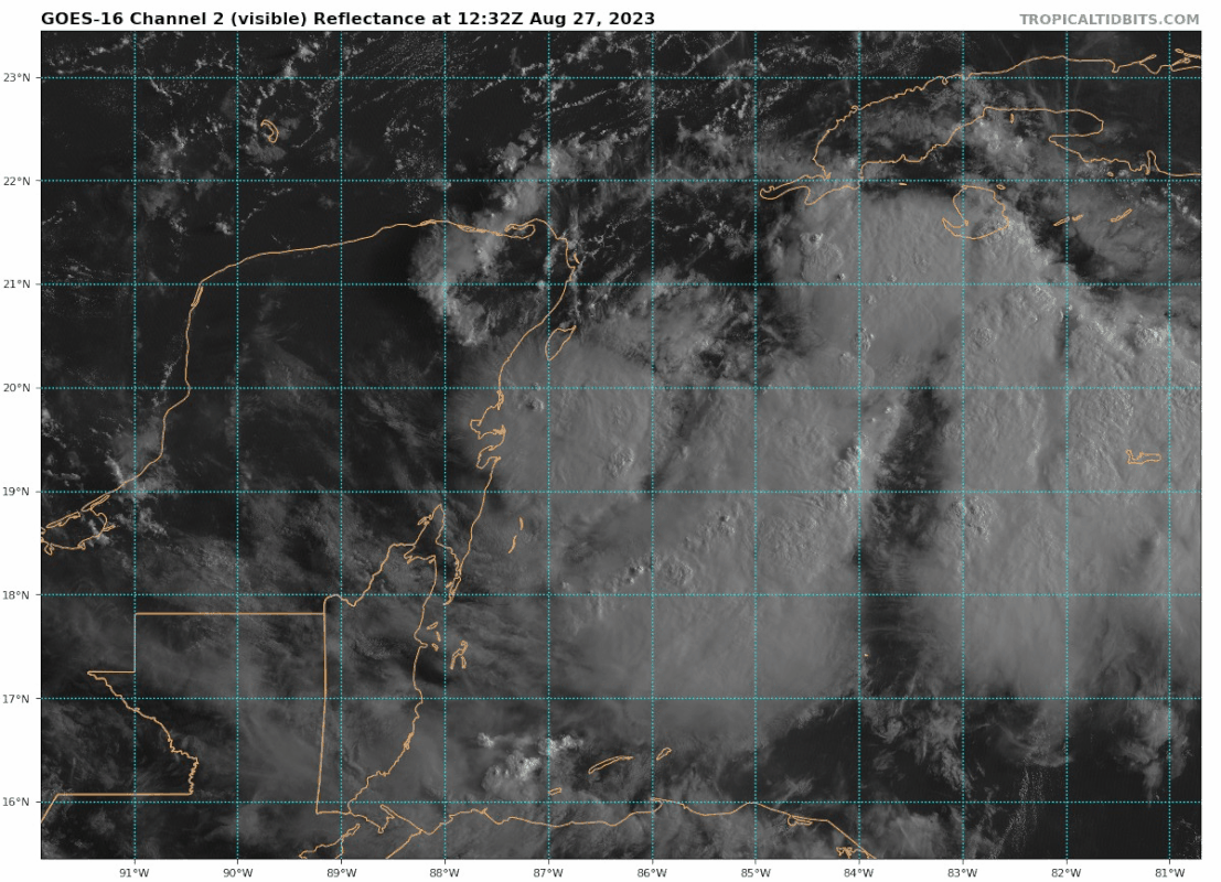
12z Best Track:

AL, 10, 2023082712, , BEST, 0, 198N, 863W, 30, 1001, TD
0 likes
Visit the Caribbean-Central America Weather Thread where you can find at first post web cams,radars
and observations from Caribbean basin members Click Here
and observations from Caribbean basin members Click Here
-
tolakram
- Admin
- Posts: 20186
- Age: 62
- Joined: Sun Aug 27, 2006 8:23 pm
- Location: Florence, KY (name is Mark)
Re: ATL: TEN - Tropical Depression - Discussion
saved loop

source: https://weather.cod.edu/satrad/?parms=meso-meso1-02-48-1-100-1&checked=map&colorbar=undefined
source: https://weather.cod.edu/satrad/?parms=meso-meso1-02-48-1-100-1&checked=map&colorbar=undefined
1 likes
M a r k
- - - - -
Join us in chat: Storm2K Chatroom Invite. Android and IOS apps also available.
The posts in this forum are NOT official forecasts and should not be used as such. Posts are NOT endorsed by any professional institution or STORM2K.org. For official information and forecasts, please refer to NHC and NWS products.
-
ScottNAtlanta

- Category 5

- Posts: 2535
- Joined: Sat May 25, 2013 3:11 pm
- Location: Atlanta, GA
Re: ATL: TEN - Tropical Depression - Discussion
Recon is just passing the Cayman Islands. Should be there soon
0 likes
The posts in this forum are NOT official forecast and should not be used as such. They are just the opinion of the poster and may or may not be backed by sound meteorological data. They are NOT endorsed by any professional institution or storm2k.org. For official information, please refer to the NHC and NWS products.
-
Hypercane_Kyle

- Category 5
- Posts: 3465
- Joined: Sat Mar 07, 2015 7:58 pm
- Location: Cape Canaveral, FL
Re: ATL: TEN - Tropical Depression - Discussion
A very tricky forecast. In many ways, similar to Ian although the intensity cap doesn't appear to be nearly as high. Cedar Key looks like a good bet for landfall IMHO
0 likes
My posts are my own personal opinion, defer to the National Hurricane Center (NHC) and other NOAA products for decision making during hurricane season.

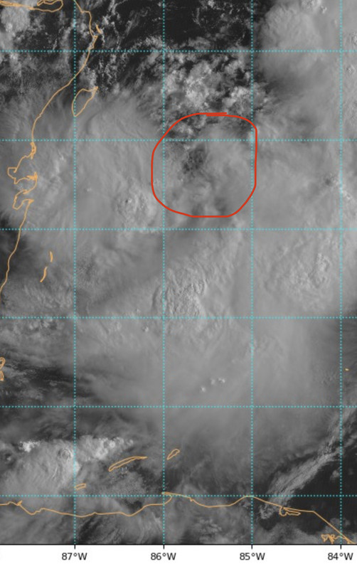
Re: ATL: TEN - Tropical Depression - Discussion
cycloneye wrote:12z Best Track:AL, 10, 2023082712, , BEST, 0, 198N, 863W, 30, 1001, TD
https://i.imgur.com/PaBwdc2.png
Coincides with ASCAT and a quick warm-core feature on IR
0 likes
-
USTropics
- Professional-Met

- Posts: 2741
- Joined: Sun Aug 12, 2007 3:45 am
- Location: Florida State University
Re: ATL: TEN - Tropical Depression - Discussion
Busy day for recon, currently 2 flights in the air with AF getting ready to depart from LA (fingers crossed):

1 likes
-
Blown Away

- S2K Supporter
- Posts: 10253
- Joined: Wed May 26, 2004 6:17 am
Re: ATL: TEN - Tropical Depression - Discussion
@19.7N/86W you can see the low level clouds of the COC moving ESE?
0 likes
Hurricane Eye Experience: David 79, Irene 99, Frances 04, Jeanne 04, Wilma 05… Hurricane Brush Experience: Andrew 92, Erin 95, Floyd 99, Matthew 16, Irma 17, Ian 22, Nicole 22…
Re: ATL: TEN - Tropical Depression - Discussion
Already 33 knts SFMR outside of some heavy convection.
IMHO, a good shot Miss Piggy will tag a TS later.
IMHO, a good shot Miss Piggy will tag a TS later.
1 likes
-
IsabelaWeather
- Category 1

- Posts: 316
- Age: 36
- Joined: Tue Jul 07, 2020 7:29 am
- Location: Isabela, Puerto Rico
Re: RE: Re: ATL: TEN - Tropical Depression - Discussion
jlauderdal wrote:NHC is very transparent about error and as good as nhc is, ian wasnt long ago so be on alert...the angle of approach makes it even more difficultrobbielyn wrote:LandoWill wrote:My 30 years of watching these storms as a Florida west coast resident, has taught me a few things. Wherever they say it's going on the first few advisories, is never where it actually goes.
THIS!
I would like to point out the first advisory track for Ian.

7 likes
-
chris_fit

- Category 5
- Posts: 3261
- Age: 43
- Joined: Wed Sep 10, 2003 11:58 pm
- Location: Tampa Bay Area, FL
Re: RE: Re: ATL: TEN - Tropical Depression - Discussion
IsabelaWeather wrote:jlauderdal wrote:NHC is very transparent about error and as good as nhc is, ian wasnt long ago so be on alert...the angle of approach makes it even more difficultrobbielyn wrote:
THIS!
I would like to point out the first advisory track for Ian.
https://i.imgur.com/Ntdj0lx.png
Many advisories later on were way W of that pointing towards the pan handle.
1 likes
-
Blown Away
- S2K Supporter
- Posts: 10253
- Joined: Wed May 26, 2004 6:17 am
Re: ATL: TEN - Tropical Depression - Discussion
GCANE wrote:Already 33 knts SFMR outside of some heavy convection.
IMHO, a good shot Miss Piggy will tag a TS later.
Please let us know where they tag the COC.
0 likes
Hurricane Eye Experience: David 79, Irene 99, Frances 04, Jeanne 04, Wilma 05… Hurricane Brush Experience: Andrew 92, Erin 95, Floyd 99, Matthew 16, Irma 17, Ian 22, Nicole 22…
-
Hypercane_Kyle
- Category 5
- Posts: 3465
- Joined: Sat Mar 07, 2015 7:58 pm
- Location: Cape Canaveral, FL
Re: ATL: TEN - Tropical Depression - Discussion
You can see on the visible loops light shear impacting 10L right now from the north... likely from Franklin's inflow. Could also be impacting the track by driving it more south than expected?
Last edited by Hypercane_Kyle on Sun Aug 27, 2023 8:40 am, edited 1 time in total.
1 likes
My posts are my own personal opinion, defer to the National Hurricane Center (NHC) and other NOAA products for decision making during hurricane season.
-
jlauderdal
- S2K Supporter
- Posts: 7240
- Joined: Wed May 19, 2004 5:46 am
- Location: NE Fort Lauderdale
- Contact:
Re: RE: Re: ATL: TEN - Tropical Depression - Discussion
chris_fit wrote:IsabelaWeather wrote:jlauderdal wrote:NHC is very transparent about error and as good as nhc is, ian wasnt long ago so be on alert...the angle of approach makes it even more difficult
I would like to point out the first advisory track for Ian.
https://i.imgur.com/Ntdj0lx.png
Many advisories later on were way W of that pointing towards the pan handle.
All the way up to the last 24 hours, that was 2022 so the forecasting level is about the same, beware folks, especially tampa south and dont focus on the line, a couple of wobbles and its your storm in a big way
1 likes
-
IsabelaWeather
- Category 1
- Posts: 316
- Age: 36
- Joined: Tue Jul 07, 2020 7:29 am
- Location: Isabela, Puerto Rico
Re: RE: Re: ATL: TEN - Tropical Depression - Discussion
chris_fit wrote:IsabelaWeather wrote:jlauderdal wrote:NHC is very transparent about error and as good as nhc is, ian wasnt long ago so be on alert...the angle of approach makes it even more difficult
I would like to point out the first advisory track for Ian.
https://i.imgur.com/Ntdj0lx.png
Many advisories later on were way W of that pointing towards the pan handle.
Ok? I am aware. Posters were saying being the landfall point in the first advisories means they don't get hit. That is not true, and not necessarily true with this storm. If you are in Pensacola to Naples I would prepare for the storm.
Last edited by IsabelaWeather on Sun Aug 27, 2023 8:58 am, edited 1 time in total.
2 likes
-
Frank P
- S2K Supporter
- Posts: 2779
- Joined: Fri Aug 29, 2003 10:52 am
- Location: Biloxi Beach, Ms
- Contact:
Re: ATL: TEN - Tropical Depression - Discussion
Using the MSFC VIS SAT LOOPS, this certainly looks like the center of TD10.
https://weather.ndc.nasa.gov/cgi-bin/post-abi

https://weather.ndc.nasa.gov/cgi-bin/post-abi
2 likes
-
TallyTracker
- Category 2

- Posts: 787
- Joined: Thu Oct 11, 2018 2:46 pm
Re: ATL: TEN - Tropical Depression - Discussion
Frank P wrote:Using the MSFC VIS SAT LOOPS, this certainly looks like the center of TD10.
https://weather.ndc.nasa.gov/cgi-bin/post-abi
https://i.ibb.co/82jjZrw/IMG-3650.jpg
I agree that looks like the center. Not sure if it’s THE center or one of several. It appears to be moving NE at a good clip.
1 likes
Fran '96, Georges '98, Gordon '00, Gabrielle '01, Charley '04, Frances '04, Jeanne '04, Barry '07, Fay '08, Debby '12, Matthew '16, Emily '17, Irma '17, Michael ‘18, Elsa ‘21, Fred ‘21, Mindy ‘21, Nicole ‘22, Idalia ‘23, Debby ‘24, Helene ‘24
Re: ATL: TEN - Tropical Depression - Discussion
Very strong surface winds in the MCS's
Largest so far is 67 knts
Largest so far is 67 knts
1 likes
Who is online
Users browsing this forum: No registered users and 99 guests