ATL: INVEST 95L - Discussion

Moderator: S2k Moderators

Message
Author
User avatar
cycloneye
Admin
Admin
Posts: 139593
Age: 67
Joined: Thu Oct 10, 2002 10:54 am
Location: San Juan, Puerto Rico

Re: ATL: INVEST 95L - Discussion

#61 Postby cycloneye » Fri Jul 21, 2023 12:39 pm

Up to 40%/60%


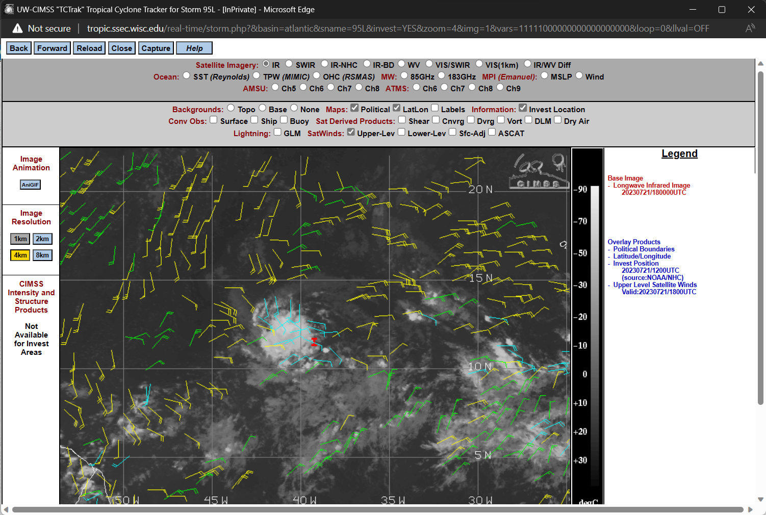
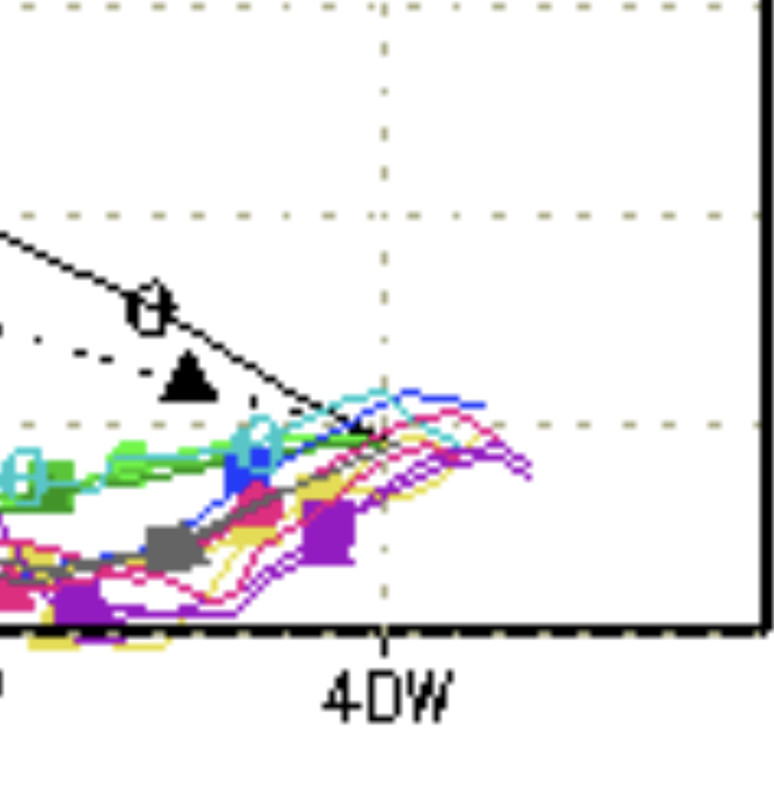
A small area of low pressure, located several hundred miles
west-southwest of the Cabo Verde Islands, is producing an area of
disorganized showers and thunderstorms over the central tropical
Atlantic. Although there is dry air located to the north of
the system, favorable upper-level winds are expected to allow for
gradual development during the next several days. This system
could become a tropical depression early next week, as it moves
westward across the tropical Atlantic.
* Formation chance through 48 hours...medium...40 percent.
* Formation chance through 7 days...medium...60 percent.
3 likes   
Visit the Caribbean-Central America Weather Thread where you can find at first post web cams,radars
and observations from Caribbean basin members Click Here

tolakram
Admin
Admin
Posts: 19182
Age: 60
Joined: Sun Aug 27, 2006 8:23 pm
Location: Florence, KY (name is Mark)

Re: ATL: INVEST 95L - Discussion

#62 Postby tolakram » Fri Jul 21, 2023 12:40 pm

Looks like center is almost exposed, if there is a well defined center.

SLIDER: https://rammb-slider.cira.colostate.edu ... aw_width=6
0 likes   
M a r k
- - - - -
Join us in chat: Storm2K Chatroom Invite. Android and IOS apps also available.

The posts in this forum are NOT official forecasts and should not be used as such. Posts are NOT endorsed by any professional institution or STORM2K.org. For official information and forecasts, please refer to NHC and NWS products.

User avatar
Blown Away
S2K Supporter
S2K Supporter
Posts: 9874
Joined: Wed May 26, 2004 6:17 am

Re: ATL: INVEST 95L - Discussion

#63 Postby Blown Away » Fri Jul 21, 2023 12:41 pm

chaser1 wrote:
Blown Away wrote:[url]https://i.postimg.cc/gk3fP60s/F47105-BE-2-EE8-456-A-9217-796-D70357-EDF.jpg [/url]

Looking at this decent structure, the models are all mostly depicting a big undefined mess which might happen, but for now IMO the models are off.


I agree that it's satellite presentation looks quite impressive especially when you look at its transition from 24 hours ago, but I just dont think we have near enough to go on beyond what best track was seeing as a weak 1014 low. There's nothing to see at the surface that would validate how tilted or whether any LLC may even be closed at all. Heck, given near center arcing outfow boundries, the center could well be filling (or at least transitory). Btw, ICON, GFS, CMC, & NavGem were all depicting a weak 1013/1014 low in yesterday's 24 hr forecast. I think its appearance is primarily 850mb and higher up


Agree it’s weak and tilted, but there was a clear weak LLC yesterday and no reason to think it isn’t still there, albeit weak.
2 likes   
Hurricane Eye Experience: David 79, Irene 99, Frances 04, Jeanne 04, Wilma 05... EYE COMING MY WAY IN 2024…
Hurricane Brush Experience: Andrew 92, Erin 95, Floyd 99, Matthew 16, Irma 17, Ian 22, Nicole 22…

Sciencerocks
Category 5
Category 5
Posts: 7300
Age: 38
Joined: Thu Jul 06, 2017 1:51 am

Re: ATL: INVEST 95L - Discussion

#64 Postby Sciencerocks » Fri Jul 21, 2023 12:42 pm

0 likes   

User avatar
GCANE
S2K Supporter
S2K Supporter
Posts: 10787
Joined: Mon Oct 22, 2007 8:03 am

Re: ATL: INVEST 95L - Discussion

#65 Postby GCANE » Fri Jul 21, 2023 12:52 pm

2 likes   

User avatar
chaser1
S2K Supporter
S2K Supporter
Posts: 4749
Age: 63
Joined: Sat Oct 15, 2005 5:59 pm
Location: Longwood, Fl

Re: ATL: INVEST 95L - Discussion

#66 Postby chaser1 » Fri Jul 21, 2023 12:56 pm

tolakram wrote:Looks like center is almost exposed, if there is a well defined center.

SLIDER: https://rammb-slider.cira.colostate.edu ... aw_width=6


Yep, thats what i see. 'Course, that could just spin off and with this new convective bursting further west, an already shallow system could well develop a new COC underneath. As an aside, that fast approaching easterly surge will likely help moisten up the broarder environment around the disturbance, but it might also impact an additional component of easterly shear in the next day or two as well. 95L might not have developed enough of a robust vertical core to withstand that.
0 likes   
Personal Forecast Disclaimer:
The posts in this forum are NOT official forecast and should not be used as such. They are just the opinion of the poster and may or may not be backed by sound meteorological data. They are NOT endorsed by any professional institution or storm2k.org. For official information, please refer to the NHC and NWS products.


User avatar
gatorcane
S2K Supporter
S2K Supporter
Posts: 23499
Age: 46
Joined: Sun Mar 13, 2005 3:54 pm
Location: Boca Raton, FL

Re: ATL: INVEST 95L - Discussion

#67 Postby gatorcane » Fri Jul 21, 2023 1:36 pm

SouthDadeFish wrote:
gatorcane wrote:
SouthDadeFish wrote:
I'd be interested in hearing why you think this. Environment looks favorable over the next 3–days or so other than the possibility of dry air intrusions. SSTs are warm (much warmer than normal) and shear looks relatively weak over this period. Considering recent convective trends, I'd argue global models aren't resolving this compact structure well. If convection can persist throughout today, I like this system's chances for genesis. It's a big "if" for now.


I agree with WxMan57. Conditions will only get worse as it moves west especially once in the Caribbean as shear really increases due to a strengthening El Niño. All of the global models are showing this. Atlantic SSTs are running above normal but the EPAC is running way above normal and so should the shear across the Caribbean this season.


I'm sorry, but this is just not accurate. For example, SHIPS, which uses GFS conditions, shows shear remaining below 10 kt throughout the next 120 hours, which is quite favorable: https://ftp.nhc.noaa.gov/atcf/stext/230 ... _ships.txt . Perhaps conditions in the Caribbean are less favorable, but this system will have a sizable window over the next five days or so.


To clarify, the shear will increase once near the Caribbean and especially in the Caribbean. The bottom-line is the system doesn’t look to have much of a future and very likely won’t become anything significant, just a small swirl of clouds which might become a short-lived depression. As you pointed out the dry air is the main issue. Shear should be the issue down the road.
0 likes   

Sciencerocks
Category 5
Category 5
Posts: 7300
Age: 38
Joined: Thu Jul 06, 2017 1:51 am

Re: ATL: INVEST 95L - Discussion

#68 Postby Sciencerocks » Fri Jul 21, 2023 1:42 pm

Image
1 likes   

tolakram
Admin
Admin
Posts: 19182
Age: 60
Joined: Sun Aug 27, 2006 8:23 pm
Location: Florence, KY (name is Mark)

ATL: INVEST 95L - Models

#69 Postby tolakram » Fri Jul 21, 2023 1:54 pm

1 likes   
M a r k
- - - - -
Join us in chat: Storm2K Chatroom Invite. Android and IOS apps also available.

The posts in this forum are NOT official forecasts and should not be used as such. Posts are NOT endorsed by any professional institution or STORM2K.org. For official information and forecasts, please refer to NHC and NWS products.

User avatar
cycloneye
Admin
Admin
Posts: 139593
Age: 67
Joined: Thu Oct 10, 2002 10:54 am
Location: San Juan, Puerto Rico

Re: ATL: INVEST 95L - Discussion

#70 Postby cycloneye » Fri Jul 21, 2023 2:02 pm

AL, 95, 2023072118, , BEST, 0, 118N, 399W, 25, 1012, LO
2 likes   
Visit the Caribbean-Central America Weather Thread where you can find at first post web cams,radars
and observations from Caribbean basin members Click Here

User avatar
Blown Away
S2K Supporter
S2K Supporter
Posts: 9874
Joined: Wed May 26, 2004 6:17 am

Re: ATL: INVEST 95L - Discussion

#71 Postby Blown Away » Fri Jul 21, 2023 2:24 pm

cycloneye wrote:
AL, 95, 2023072118, , BEST, 0, 118N, 399W, 25, 1012, LO


Convection popping over that position. A little N of 12z.
0 likes   
Hurricane Eye Experience: David 79, Irene 99, Frances 04, Jeanne 04, Wilma 05... EYE COMING MY WAY IN 2024…
Hurricane Brush Experience: Andrew 92, Erin 95, Floyd 99, Matthew 16, Irma 17, Ian 22, Nicole 22…

User avatar
Iceresistance
Category 5
Category 5
Posts: 8931
Age: 20
Joined: Sat Oct 10, 2020 9:45 am
Location: Tecumseh, OK/Norman, OK

Re: ATL: INVEST 95L - Discussion

#72 Postby Iceresistance » Fri Jul 21, 2023 2:28 pm

It's already developing upper-level outflow.

Like, seriously, 2022 all over again with Invests having good outflow before being named?

Image
https://s12.gifyu.com/images/SWJjg.png
6 likes   
Bill 2015 & Beta 2020

Winter 2020-2021 :cold:

All observations are in Tecumseh, OK unless otherwise noted.

Winter posts are focused mainly for Oklahoma & Texas.

Take any of my forecasts with a grain of salt, refer to the NWS, SPC, and NHC for official information

Never say Never with weather! Because ANYTHING is possible!

zzzh
Category 2
Category 2
Posts: 560
Joined: Thu Sep 02, 2021 1:13 pm

Re: ATL: INVEST 95L - Discussion

#73 Postby zzzh » Fri Jul 21, 2023 3:19 pm

Image
4 likes   

User avatar
ScottNAtlanta
Category 5
Category 5
Posts: 2014
Joined: Sat May 25, 2013 3:11 pm
Location: Atlanta, GA

Re: ATL: INVEST 95L - Models

#74 Postby ScottNAtlanta » Fri Jul 21, 2023 3:19 pm


That offset center is getting pulled under that big blowup of convection
1 likes   
The posts in this forum are NOT official forecast and should not be used as such. They are just the opinion of the poster and may or may not be backed by sound meteorological data. They are NOT endorsed by any professional institution or storm2k.org. For official information, please refer to the NHC and NWS products.

User avatar
wxman57
Moderator-Pro Met
Moderator-Pro Met
Posts: 22506
Age: 66
Joined: Sat Jun 21, 2003 8:06 pm
Location: Houston, TX (southwest)

Re: ATL: INVEST 95L - Discussion

#75 Postby wxman57 » Fri Jul 21, 2023 3:41 pm

LarryWx wrote:
wxman57 wrote:It doesn't appear to have much of a future. Wind shear will increase as it nears or enters the Caribbean. Will probably move into Central America in a week as a wave. Might be classified as a depression at some point east of the Caribbean.


Regardless of your downplaying, the Lesser Antilles are in the path before it gets into the hostile Caribbean and will thus be affected by a tropical entity of unknown strength. Nobody knows how strong or weak it will be then. A TS is a distinct possibility.


Just made our first forecast tack. Takes it very near Barbados Tuesday morning as a 35kt TS, enters Caribbean just south of St. Lucia around noon Tuesday as a 30-35kt system, weakening due to shear. Dissipates in central Caribbean Wednesday near 14N/71W. Moves into Central America Friday as a wave. It's going to be a VERY small system. Any fluctuation in environmental shear could result in rapid changes in intensity up or down. No impacts across U.S. or British Virgin Islands or Luis in PR.
6 likes   

User avatar
cycloneye
Admin
Admin
Posts: 139593
Age: 67
Joined: Thu Oct 10, 2002 10:54 am
Location: San Juan, Puerto Rico

Re: ATL: INVEST 95L - Discussion

#76 Postby cycloneye » Fri Jul 21, 2023 3:53 pm

Looking good.

Image
1 likes   
Visit the Caribbean-Central America Weather Thread where you can find at first post web cams,radars
and observations from Caribbean basin members Click Here

zzzh
Category 2
Category 2
Posts: 560
Joined: Thu Sep 02, 2021 1:13 pm

Re: ATL: INVEST 95L - Discussion

#77 Postby zzzh » Fri Jul 21, 2023 3:56 pm

:uarrow: LLCC is in the northeast of the convection.
0 likes   

User avatar
Blown Away
S2K Supporter
S2K Supporter
Posts: 9874
Joined: Wed May 26, 2004 6:17 am

Re: ATL: INVEST 95L - Discussion

#78 Postby Blown Away » Fri Jul 21, 2023 4:00 pm

zzzh wrote::uarrow: LLCC is in the northeast of the convection.


Image

Continues W with no S component and N of 12z models.
1 likes   
Hurricane Eye Experience: David 79, Irene 99, Frances 04, Jeanne 04, Wilma 05... EYE COMING MY WAY IN 2024…
Hurricane Brush Experience: Andrew 92, Erin 95, Floyd 99, Matthew 16, Irma 17, Ian 22, Nicole 22…

BobHarlem
Category 5
Category 5
Posts: 1668
Joined: Thu Oct 20, 2005 6:11 pm

Re: ATL: INVEST 95L - Discussion

#79 Postby BobHarlem » Fri Jul 21, 2023 5:28 pm

95L in perspective, still really tiny, and with circular convection.

Image
4 likes   

User avatar
Ivanhater
Storm2k Moderator
Storm2k Moderator
Posts: 10859
Age: 37
Joined: Fri Jul 01, 2005 8:25 am
Location: Pensacola

Re: ATL: INVEST 95L - Discussion

#80 Postby Ivanhater » Fri Jul 21, 2023 6:17 pm

Code Red

MIATWOAT ALL
TTAA00 KNHC DDHHMM

Tropical Weather Outlook
NWS National Hurricane Center Miami FL
800 PM EDT Fri Jul 21 2023

For the North Atlantic...Caribbean Sea and the Gulf of Mexico:

Active Systems:
The National Hurricane Center is issuing advisories on Tropical
Storm Don, located over the central Atlantic.

1. Central Tropical Atlantic (AL95):
A small area of low pressure located roughly midway between the Cabo
Verde Islands and the Lesser Antilles continues to produce
disorganized showers and thunderstorms. Although environmental
conditions are only marginally conducive, slow development is
expected and this system will likely become a tropical depression
early next week while it moves westward across the tropical
Atlantic.
* Formation chance through 48 hours...medium...50 percent.
* Formation chance through 7 days...high...70 percent.

Forecaster Cangialosi/Roberts
Image
3 likes   
Michael


Return to “2023”

Who is online

Users browsing this forum: No registered users and 4 guests