EPAC: HILARY - Post-Tropical - Discussion
Moderator: S2k Moderators
-
Kingarabian

- S2K Supporter

- Posts: 16379
- Joined: Sat Aug 08, 2009 3:06 am
- Location: Honolulu, Hawaii
Re: EPAC: HILARY - Tropical Storm - Discussion
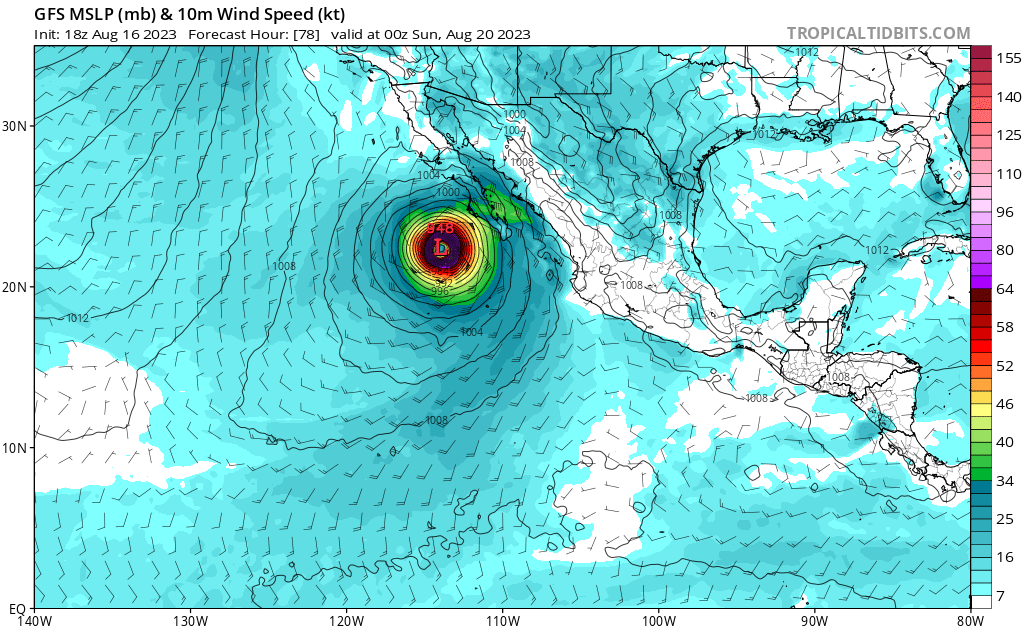
GFS IR simulations show this maintaining deep convection into SWCONUS.
0 likes
RIP Kobe Bryant
-
wxman57

- Moderator-Pro Met

- Posts: 23175
- Age: 68
- Joined: Sat Jun 21, 2003 8:06 pm
- Location: Houston, TX (southwest)
Re: EPAC: HILARY - Tropical Storm - Discussion
NHC's 21Z day five point is inland between San Diego and Los Angeles at 18Z Monday. Reasonable track. Most moisture should be east of the track.
0 likes
-
Sciencerocks
- Category 5

- Posts: 10193
- Age: 40
- Joined: Thu Jul 06, 2017 1:51 am

-
Iceresistance

- Category 5
- Posts: 9607
- Age: 22
- Joined: Sat Oct 10, 2020 9:45 am
- Location: Tecumseh, OK/Norman, OK
Re: EPAC: HILARY - Tropical Storm - Discussion
Anyone in California, Arizona, and Nevada needs to take this very seriously.
1 likes
Bill 2015 & Beta 2020
Winter 2020-2021
All observations are in Tecumseh, OK unless otherwise noted.
Winter posts are focused mainly for Oklahoma & Texas.
Take any of my forecasts with a grain of salt, refer to the NWS, SPC, and NHC for official information
Never say Never with weather! Because ANYTHING is possible!
Winter 2020-2021
All observations are in Tecumseh, OK unless otherwise noted.
Winter posts are focused mainly for Oklahoma & Texas.
Take any of my forecasts with a grain of salt, refer to the NWS, SPC, and NHC for official information
Never say Never with weather! Because ANYTHING is possible!
-
Bocadude85

- Category 5
- Posts: 2991
- Age: 39
- Joined: Mon Apr 18, 2005 2:20 pm
- Location: Honolulu,Hi
Re: EPAC: HILARY - Tropical Storm - Discussion
I’m currently in Ventura,Ca..the NHC track looks to bring the remnants inland fairly close to me, not expecting much more then some rain.. interesting track that’s for sure.
0 likes
-
Yellow Evan

- Professional-Met

- Posts: 16257
- Age: 27
- Joined: Fri Jul 15, 2011 12:48 pm
- Location: Henderson, Nevada/Honolulu, HI
- Contact:
Re: EPAC: HILARY - Tropical Storm - Discussion

Bursting seems more consolidated, which is an indication it’s trying to stack. Convection is still stuck downshear so we have a ways to go before this really takes off. Northerly shear a bit more of a problem than I expected. We still have almost 3 days so there’s still time to form a core but I’m not confident in this being any stronger than Genevieve 20.
0 likes
-
cycloneye

- Admin

- Posts: 149719
- Age: 69
- Joined: Thu Oct 10, 2002 10:54 am
- Location: San Juan, Puerto Rico
Re: EPAC: HILARY - Tropical Storm - Discussion
0 likes
Visit the Caribbean-Central America Weather Thread where you can find at first post web cams,radars
and observations from Caribbean basin members Click Here
and observations from Caribbean basin members Click Here
-
Yellow Evan
- Professional-Met
- Posts: 16257
- Age: 27
- Joined: Fri Jul 15, 2011 12:48 pm
- Location: Henderson, Nevada/Honolulu, HI
- Contact:
Re: EPAC: HILARY - Tropical Storm - Discussion
The GFS runs that show unreal precipitation rainfalls over the Mojave Desert and Colorado River Valley are unlikely to verify as the GFS can not properly resolve the terrain of the region. We’ve seen these greatly overestimate precipitation forecasts of decaying TCs in the past (Kay, Rosa, Odile).
0 likes
-
cycloneye
- Admin
- Posts: 149719
- Age: 69
- Joined: Thu Oct 10, 2002 10:54 am
- Location: San Juan, Puerto Rico
Re: EPAC: HILARY - Tropical Storm - Discussion
0 likes
Visit the Caribbean-Central America Weather Thread where you can find at first post web cams,radars
and observations from Caribbean basin members Click Here
and observations from Caribbean basin members Click Here
-
Monsoonjr99
- Tropical Storm

- Posts: 210
- Age: 26
- Joined: Fri Sep 21, 2018 11:22 pm
- Location: Inland Empire, SoCal
Re: EPAC: HILARY - Tropical Storm - Discussion
Not often that a tropical cyclone heads my way. Will be interesting to track.
Starting to look potent now.
Starting to look potent now.
0 likes
The posts in this forum are NOT official forecasts and should not be used as such. They are just the opinion of the poster and may or may not be backed by sound meteorological data. They are NOT endorsed by any professional institution or STORM2K. For official information, please refer to products from the NHC and NWS.
Some Californian who codes things and tracks weather.
Kay '22, Hilary '23


Re: EPAC: HILARY - Tropical Storm - Discussion
Should be a hurricane by morning you would think.


0 likes
The above post and any post by Ntxw is NOT an official forecast and should not be used as such. It is just the opinion of the poster and may or may not be backed by sound meteorological data. It is NOT endorsed by any professional institution including Storm2k. For official information, please refer to NWS products.
Help support Storm2K!

-
dexterlabio
- Category 5
- Posts: 3517
- Joined: Sat Oct 24, 2009 11:50 pm
Re: EPAC: HILARY - Tropical Storm - Discussion
^It looks like something you see in the WPAC.
1 likes
Personal Forecast Disclaimer:
The posts in this forum are NOT official forecast and should not be used as such. They are just the opinion of the poster and may or may not be backed by sound meteorological data. They are NOT endorsed by any professional institution or storm2k.org. For official information, please refer to the NHC and NWS products.
The posts in this forum are NOT official forecast and should not be used as such. They are just the opinion of the poster and may or may not be backed by sound meteorological data. They are NOT endorsed by any professional institution or storm2k.org. For official information, please refer to the NHC and NWS products.
-
cycloneye
- Admin
- Posts: 149719
- Age: 69
- Joined: Thu Oct 10, 2002 10:54 am
- Location: San Juan, Puerto Rico
Re: EPAC: HILARY - Tropical Storm - Discussion
Here we go. I thought a little more higher but it's ok.
EP, 09, 2023081700, , BEST, 0, 131N, 1045W, 45, 996, TS
0 likes
Visit the Caribbean-Central America Weather Thread where you can find at first post web cams,radars
and observations from Caribbean basin members Click Here
and observations from Caribbean basin members Click Here

-
cycloneye
- Admin
- Posts: 149719
- Age: 69
- Joined: Thu Oct 10, 2002 10:54 am
- Location: San Juan, Puerto Rico
Re: EPAC: HILARY - Tropical Storm - Discussion
TXPZ25 KNES 170028
TCSENP
A. 09E (HILARY)
B. 17/0000Z
C. 13.1N
D. 104.6W
E. THREE/GOES-E
F. T2.5/2.5
G. IR/EIR/VIS
H. REMARKS...7/10 BANDING IN W YIELDS A DT OF 3.5. THE MET IS 2.0. THE
PT IS 2.5. THE FT IS BASED ON THE PT DUE TO THE PUSLING CONVECTION.
I. ADDL POSITIONS
NIL
...BROWN
TCSENP
A. 09E (HILARY)
B. 17/0000Z
C. 13.1N
D. 104.6W
E. THREE/GOES-E
F. T2.5/2.5
G. IR/EIR/VIS
H. REMARKS...7/10 BANDING IN W YIELDS A DT OF 3.5. THE MET IS 2.0. THE
PT IS 2.5. THE FT IS BASED ON THE PT DUE TO THE PUSLING CONVECTION.
I. ADDL POSITIONS
NIL
...BROWN
0 likes
Visit the Caribbean-Central America Weather Thread where you can find at first post web cams,radars
and observations from Caribbean basin members Click Here
and observations from Caribbean basin members Click Here

-
Yellow Evan
- Professional-Met
- Posts: 16257
- Age: 27
- Joined: Fri Jul 15, 2011 12:48 pm
- Location: Henderson, Nevada/Honolulu, HI
- Contact:
Re: EPAC: HILARY - Tropical Storm - Discussion
CB just occurred in the upshear right and convection in general is curling into the upshear semicircle. This should be a hurricane in the morning. I'd wait to see how large its core is before assessing RI chances past minimal hurricane status but really ever since it was invested 48 hours ago, it has been organizing at a very quick pace.
Last edited by Yellow Evan on Wed Aug 16, 2023 8:18 pm, edited 1 time in total.
0 likes

-
cycloneye
- Admin
- Posts: 149719
- Age: 69
- Joined: Thu Oct 10, 2002 10:54 am
- Location: San Juan, Puerto Rico
Re: EPAC: HILARY - Tropical Storm - Discussion
* EAST PACIFIC 2023 SHIPS INTENSITY FORECAST *
* IR SAT DATA AVAILABLE, OHC AVAILABLE *
* HILARY EP092023 08/17/23 00 UTC *
TIME (HR) 0 6 12 18 24 36 48 60 72 84 96 108 120 132 144 156 168
V (KT) NO LAND 45 52 62 73 85 104 115 119 115 101 79 59 36 35 31 N/A N/A
V (KT) LAND 45 52 62 73 85 104 115 119 115 101 79 59 37 31 31 N/A N/A
V (KT) LGEM 45 51 59 68 79 104 127 133 113 83 55 33 22 25 28 N/A N/A
Storm Type TROP TROP TROP TROP TROP TROP TROP TROP TROP TROP TROP TROP EXTP EXTP EXTP N/A N/A
SHEAR (KT) 10 7 4 4 5 9 6 5 5 4 11 16 18 17 16 N/A N/A
SHEAR ADJ (KT) -5 -5 -4 -4 -5 -4 -2 -2 12 5 1 3 4 0 -1 N/A N/A
SHEAR DIR 24 334 308 119 101 76 67 52 204 199 153 198 182 208 201 N/A N/A
SST (C) 30.0 30.0 30.0 29.7 29.8 29.9 30.1 28.9 26.2 24.8 21.5 20.3 18.6 16.8 20.4 N/A N/A
POT. INT. (KT) 166 166 166 163 164 165 167 154 127 113 79 67 61 58 65 N/A N/A
200 MB T (C) -51.0 -51.4 -51.3 -50.9 -50.3 -50.5 -49.6 -49.5 -48.5 -48.5 -48.1 -48.1 -47.8 -48.9 -50.0 N/A N/A
200 MB VXT (C) 0.7 0.7 0.7 0.9 0.9 1.0 1.4 1.4 1.7 1.7 1.0 1.2 1.1 0.0 0.0 N/A N/A
TH_E DEV (C) 5 5 6 6 6 6 6 4 3 2 2 1 2 2 3 N/A N/A
700-500 MB RH 85 85 85 86 84 84 82 77 71 60 51 49 47 37 33 N/A N/A
MODEL VTX (KT) 29 30 33 36 39 43 46 49 49 43 34 25 10 LOST LOST LOST LOST
850 MB ENV VOR 58 47 49 62 67 90 109 103 109 114 124 79 105 35 11 N/A N/A
200 MB DIV 128 137 141 174 214 181 165 135 143 47 33 27 65 1 -13 N/A N/A
700-850 TADV -9 -8 -5 -6 -3 -7 1 2 5 0 3 2 1 0 4 N/A N/A
LAND (KM) 588 573 578 592 615 667 576 470 318 195 128 74 -51 -99 4 N/A N/A
LAT (DEG N) 13.1 13.7 14.2 14.8 15.3 16.7 18.2 20.3 22.7 25.4 28.6 31.8 34.8 xx.x xx.x N/A N/A
LONG(DEG W) 104.5 105.6 106.7 107.8 108.9 110.7 112.3 113.6 114.2 114.9 116.1 117.6 119.3 xxx.x xxx.x N/A N/A
STM SPEED (KT) 11 12 12 12 11 11 11 12 13 15 17 17 10 3 9 N/A N/A
HEAT CONTENT 39 36 32 24 24 28 28 12 0 0 0 0 0 0 0 N/A N/A
FORECAST TRACK FROM OFCI INITIAL HEADING/SPEED (DEG/KT):285/ 10 CX,CY: -9/ 3
T-12 MAX WIND: 35 PRESSURE OF STEERING LEVEL (MB): 505 (MEAN=588)
GOES IR BRIGHTNESS TEMP. STD DEV. 50-200 KM RAD: 11.9 (MEAN=14.5)
% GOES IR PIXELS WITH T < -20 C 50-200 KM RAD: 98.0 (MEAN=65.0)
PRELIM RI PROB (DV .GE. 35 KT IN 36 HR): 82.3
INDIVIDUAL CONTRIBUTIONS TO INTENSITY CHANGE
6 12 18 24 36 48 60 72 84 96 108 120 132 144 156 168
--------------------------------------------------------------------------------------------
SAMPLE MEAN CHANGE 0. 1. 1. 1. 1. 2. 2. 1. 1. -0. -1. -1. -2. -3. 0. 0.
SST POTENTIAL 1. 2. 3. 4. 8. 12. 15. 17. 16. 13. 10. 6. 6. 4. 0. 0.
VERTICAL SHEAR MAG 0. 1. 2. 2. 4. 5. 7. 8. 10. 11. 12. 13. 13. 10. 0. 0.
VERTICAL SHEAR ADJ 0. 1. 1. 2. 3. 3. 3. 2. 1. 0. 0. 0. 0. 0. 0. 0.
VERTICAL SHEAR DIR 0. -0. -0. 0. 1. 2. 2. 1. 2. 1. 1. 1. 1. 1. 0. 0.
PERSISTENCE 2. 3. 3. 3. 3. 2. 2. 2. 2. 2. 1. 2. 1. 1. 0. 0.
200/250 MB TEMP. -0. -0. -1. -1. -2. -1. -1. -0. 1. 3. 4. 6. 7. 7. 0. 0.
THETA_E EXCESS -0. -0. -0. -0. -0. -1. -1. -2. -3. -4. -4. -4. -5. -5. 0. 0.
700-500 MB RH 0. 0. 1. 1. 2. 2. 2. 2. 2. 2. 1. 1. 0. 0. 0. 0.
MODEL VTX TENDENCY 0. 2. 4. 7. 10. 16. 24. 26. 18. 5. -6. -23. -21. -19. 0. 0.
850 MB ENV VORTICITY 0. 0. 0. 0. 0. 0. -0. -0. -1. -1. -1. -1. -1. -1. 0. 0.
200 MB DIVERGENCE 0. 1. 1. 2. 2. 3. 5. 8. 8. 7. 6. 4. 1. -0. 0. 0.
850-700 T ADVEC 0. 0. 0. 0. 0. 0. 0. 0. 0. 0. 0. -0. 0. 0. 0. 0.
ZONAL STORM MOTION 0. -0. -0. -0. 0. 0. 0. -0. -0. -0. -0. -0. -0. -0. 0. 0.
STEERING LEVEL PRES -0. -0. -0. -1. -1. -1. -1. -1. -1. -2. -2. -2. -2. -2. 0. 0.
DAYS FROM CLIM. PEAK 0. 0. 0. 0. 1. 1. 1. 1. 2. 2. 3. 3. 3. 4. 0. 0.
GOES PREDICTORS 1. 2. 2. 2. 2. 2. 2. 2. 2. 3. 3. 3. 3. 3. 0. 0.
OCEAN HEAT CONTENT -0. -0. -0. -0. -0. 0. 0. 0. -0. -0. -0. 0. 0. 1. 0. 0.
RI POTENTIAL 2. 6. 11. 16. 26. 23. 13. 3. -3. -9. -14. -16. -16. -16. 0. 0.
--------------------------------------------------------------------------------------------
TOTAL CHANGE 7. 17. 28. 40. 59. 70. 74. 70. 56. 34. 14. -9. -10. -14. 0. 0.
CURRENT MAX WIND (KT): 45. LAT, LON: 13.1 104.5
** 2023 E. PACIFIC RI INDEX EP092023 HILARY 08/17/23 00 UTC **
(SHIPS-RII PREDICTOR TABLE for 30 KT OR MORE MAXIMUM WIND INCREASE IN NEXT 24-h)
Predictor Value RI Predictor Range Scaled Value(0-1) % Contribution
POT = MPI-VMAX (KT) : 119.8 36.9 to 148.5 0.74 26.0
12 HR PERSISTENCE (KT) : 10.0 -22.0 to 44.0 0.48 14.7
MULTI-LAYER SHEAR (KT) : 11.3 30.9 to 7.7 0.85 20.2
BL DRY-AIR FLUX (W/M2) : -7.0 816.2 to -81.4 0.92 -24.8
D200 (10**7s-1) : 158.8 -33.0 to 159.5 1.00 20.9
MAXIMUM WIND (KT) : 45.0 22.5 to 132.0 0.64 13.1
STD DEV OF IR BR TEMP : 11.9 37.8 to 2.1 0.73 12.2
HEAT CONTENT (KJ/CM2) : 31.0 2.7 to 103.4 0.28 2.9
%area of TPW <45 mm upshear : 0.0 49.8 to 0.0 1.00 6.4
2nd PC OF IR BR TEMP : -0.5 2.2 to -2.3 0.61 0.2
SHIPS Prob RI for 20kt/ 12hr RI threshold= 43% is 6.8 times climatological mean ( 6.3%)
SHIPS Prob RI for 25kt/ 24hr RI threshold= 99% is 7.6 times climatological mean (12.5%)
SHIPS Prob RI for 30kt/ 24hr RI threshold= 92% is 11.1 times climatological mean ( 8.6%)
SHIPS Prob RI for 35kt/ 24hr RI threshold= 87% is 14.0 times climatological mean ( 6.2%)
SHIPS Prob RI for 40kt/ 24hr RI threshold= 63% is 15.0 times climatological mean ( 4.2%)
SHIPS Prob RI for 45kt/ 36hr RI threshold= 100% is 14.9 times climatological mean ( 6.7%)
SHIPS Prob RI for 55kt/ 48hr RI threshold= 100% is 16.9 times climatological mean ( 5.9%)
SHIPS Prob RI for 65kt/ 72hr RI threshold= 69% is 14.7 times climatological mean ( 4.7%)
Matrix of RI probabilities
------------------------------------------------------------------------------
RI (kt / h) | 20/12 | 25/24 | 30/24 | 35/24 | 40/24 | 45/36 | 55/48 |65/72
------------------------------------------------------------------------------
SHIPS-RII: 42.5% 99.1% 91.8% 86.9% 63.2% 100.0% 100.0% 68.9%
Logistic: 36.7% 83.3% 68.8% 61.3% 51.1% 79.6% 80.4% 6.8%
Bayesian: 39.7% 78.1% 67.7% 51.5% 27.2% 75.8% 56.8% 5.7%
Consensus: 39.6% 86.8% 76.1% 66.6% 47.1% 85.1% 79.1% 27.1%
DTOPS: 34.0% 79.0% 78.0% 71.0% 48.0% 69.0% 73.0% 24.0%
## ANNULAR HURRICANE INDEX (AHI) EP092023 HILARY 08/17/23 00 UTC ##
## STORM NOT ANNULAR, SCREENING STEP FAILED, NPASS=3 NFAIL=4 ##
## AHI= 0 (AHI OF 100 IS BEST FIT TO ANN. STRUC., 1 IS MARGINAL, 0 IS NOT ANNULAR) ##
0 likes
Visit the Caribbean-Central America Weather Thread where you can find at first post web cams,radars
and observations from Caribbean basin members Click Here
and observations from Caribbean basin members Click Here
-
cycloneye
- Admin
- Posts: 149719
- Age: 69
- Joined: Thu Oct 10, 2002 10:54 am
- Location: San Juan, Puerto Rico
Re: EPAC: HILARY - Tropical Storm - Discussion
HAFS-A to SW California as a TS.

0 likes
Visit the Caribbean-Central America Weather Thread where you can find at first post web cams,radars
and observations from Caribbean basin members Click Here
and observations from Caribbean basin members Click Here
Who is online
Users browsing this forum: No registered users and 56 guests