ATL: FRANKLIN - Post-Tropical - Discussion
Moderator: S2k Moderators


Re: ATL: INVEST 90L - Discussion
Sciencerocks wrote:https://imagizer.imageshack.com/img923/5148/Z3Wd5C.gif
I'm seeing a rotation near 11.5N(?) 65.0W in that loop. And it's moving SW!
0 likes

Re: ATL: INVEST 90L - Discussion
Wow was not expecting this to be 50-55 kt already. TS Franklin at 5?
1 likes
Irene '11 Sandy '12 Hermine '16 5/15/2018 Derecho Fay '20 Isaias '20 Elsa '21 Henri '21 Ida '21
I am only a meteorology enthusiast who knows a decent amount about tropical cyclones. Look to the professional mets, the NHC, or your local weather office for the best information.
I am only a meteorology enthusiast who knows a decent amount about tropical cyclones. Look to the professional mets, the NHC, or your local weather office for the best information.
Re: ATL: INVEST 90L - Discussion
AL, 90, 2023082018, , BEST, 0, 144N, 666W, 40, 1000, LO, 34, NEQ, 50, 0, 0, 40, 1008, 170, 20, 0, 0, L, 0, , 0, 0, INVEST, M, 0, , 0, 0, 0, 0, genesis-num, 020,
We are going to have another TS on bell ringing day
2 likes
-
REDHurricane

- Category 1

- Posts: 438
- Age: 28
- Joined: Sun Jul 03, 2022 2:36 pm
- Location: Northeast Pacific Ocean
Re: ATL: INVEST 90L - Discussion
zzzh wrote: We are going to have another TS on bell ringing day
We could even get 4 by the end of today if TD6 is able to pull itself together (not looking likely) and 91L can intensify faster than expected (semi-decent chance)
1 likes

Re: ATL: INVEST 90L - Discussion
Soon to be Franklin has a legit tight LLC, look at the tight pressure gradient, thus the higher winds than expected by many.
Pressure is probably lower than 1000mb because they avoided the center of it because of deep convection.

Pressure is probably lower than 1000mb because they avoided the center of it because of deep convection.
1 likes
Re: ATL: INVEST 90L - Discussion
REDHurricane wrote:zzzh wrote: We are going to have another TS on bell ringing day
We could even get 4 by the end of today if TD6 is able to pull itself together (not looking likely) and 91L can intensify faster than expected (semi-decent chance)
No way 91L will be able to become a NS today. Maybe tomorrow morning if it organizes quickly. Regardless, it sure feels like bell ringing day.
0 likes
Irene '11 Sandy '12 Hermine '16 5/15/2018 Derecho Fay '20 Isaias '20 Elsa '21 Henri '21 Ida '21
I am only a meteorology enthusiast who knows a decent amount about tropical cyclones. Look to the professional mets, the NHC, or your local weather office for the best information.
I am only a meteorology enthusiast who knows a decent amount about tropical cyclones. Look to the professional mets, the NHC, or your local weather office for the best information.

Re: ATL: INVEST 90L - Discussion
Well I certainly wasn't expecting this to do much yet. Looks like it's just on the cusp of developing, I imagine the next recon pass will determine if we get another named storm today or not.
0 likes
The above post is not official and should not be used as such. It is the opinion of the poster and may or may not be backed by sound meteorological data. It is not endorsed by any professional institution or storm2k.org. For official information, please refer to the NHC and NWS products.
-
tolakram
- Admin

- Posts: 20186
- Age: 62
- Joined: Sun Aug 27, 2006 8:23 pm
- Location: Florence, KY (name is Mark)
Re: ATL: INVEST 90L - Discussion
Floater on it: https://weather.cod.edu/satrad/?parms=meso-meso2-02-24-0-100-1&checked=map&colorbar=undefined
GOES Image viewer: https://www.star.nesdis.noaa.gov/GOES/meso_band.php?sat=G16&lat=14N&lon=68W&band=GEOCOLOR&length=90&dim=1
GOES Image viewer: https://www.star.nesdis.noaa.gov/GOES/meso_band.php?sat=G16&lat=14N&lon=68W&band=GEOCOLOR&length=90&dim=1
1 likes
M a r k
- - - - -
Join us in chat: Storm2K Chatroom Invite. Android and IOS apps also available.
The posts in this forum are NOT official forecasts and should not be used as such. Posts are NOT endorsed by any professional institution or STORM2K.org. For official information and forecasts, please refer to NHC and NWS products.
-
Blown Away

- S2K Supporter

- Posts: 10253
- Joined: Wed May 26, 2004 6:17 am
Re: ATL: INVEST 90L - Discussion
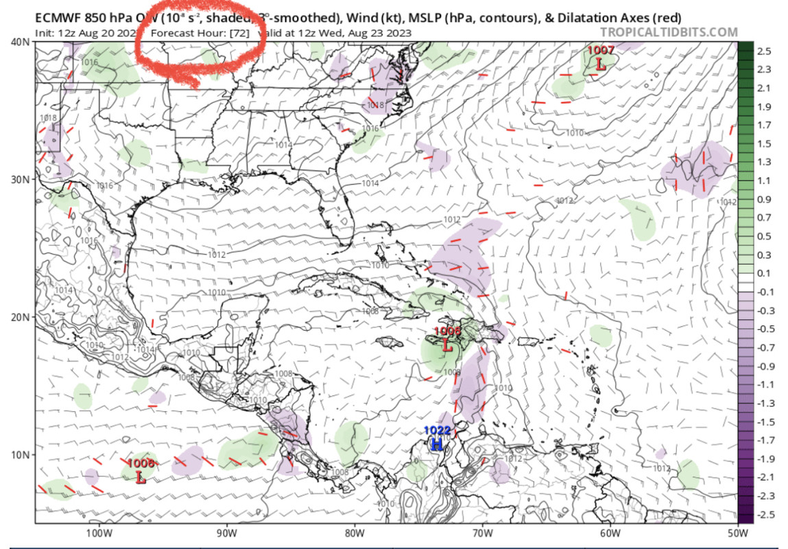
90L still moving at a good clip and seems like arrival to Hispaniola should be much sooner than 72 hours? 12z Euro went a little farther W before turning towards Haiti and seemed to result in farther W once in SW Atlantic.
0 likes
Hurricane Eye Experience: David 79, Irene 99, Frances 04, Jeanne 04, Wilma 05… Hurricane Brush Experience: Andrew 92, Erin 95, Floyd 99, Matthew 16, Irma 17, Ian 22, Nicole 22…
Re: ATL: INVEST 90L - Discussion
Best Track update is a tropical storm

2 likes
The above post is not official and should not be used as such. It is the opinion of the poster and may or may not be backed by sound meteorological data. It is not endorsed by any professional institution or storm2k.org. For official information, please refer to the NHC and NWS products.
Re: ATL: INVEST 90L - Discussion
Recon's second pass confirms a closed tight little circulation.
URNT15 KWBC 202003
NOAA3 01BBA INVEST HDOB 17 20230820
195400 1439N 06703W 9523 00448 0015 +267 +244 023003 007 022 000 00
195430 1437N 06702W 9499 00475 0019 +261 +245 289008 010 025 000 00
195500 1436N 06701W 9497 00478 0021 +260 +250 284012 012 027 000 00
195530 1434N 06700W 9508 00473 0024 +257 +247 265013 014 028 000 03
195600 1432N 06658W 9502 00477 0023 +263 +240 251015 015 026 000 00
195630 1431N 06657W 9513 00470 0026 +257 +244 232015 016 026 000 00
195700 1430N 06656W 9507 00473 0027 +256 +240 232015 016 026 000 00
195730 1429N 06654W 9493 00488 0029 +256 +241 227014 016 037 000 00
195800 1427N 06653W 9501 00483 0030 +254 +243 216018 020 037 001 00
195830 1426N 06651W 9508 00477 0034 +252 +244 211023 023 038 008 00
195900 1425N 06650W 9517 00475 0037 +249 +244 207020 023 038 006 00
195930 1423N 06649W 9508 00482 0037 +254 +242 207021 022 043 004 00
200000 1422N 06648W 9519 00472 0039 +253 +239 206022 023 051 021 00
200030 1421N 06646W 9519 00472 0040 +249 +243 204020 021 047 037 00
200100 1420N 06645W 9508 00486 0043 +248 +241 197019 021 044 016 00
200130 1418N 06644W 9520 00476 0045 +249 +241 194021 022 044 002 00
200200 1417N 06642W 9517 00481 0046 +251 +240 195021 023 040 000 00
200230 1416N 06641W 9507 00489 0047 +250 +238 193022 023 038 000 00
200300 1415N 06640W 9537 00463 0047 +251 +238 191021 024 038 002 00
200330 1413N 06639W 9524 00475 0046 +251 +234 189021 023 037 003 00
0 likes
-
ElectricStorm

- Category 5

- Posts: 5155
- Age: 25
- Joined: Tue Aug 13, 2019 11:23 pm
- Location: Norman, OK
Re: ATL: INVEST 90L - Discussion
Looks closed on recon. Hello Franklin
0 likes
B.S Meteorology, University of Oklahoma '25
Please refer to the NHC, NWS, or SPC for official information.
Please refer to the NHC, NWS, or SPC for official information.
-
Sciencerocks
- Category 5
- Posts: 10193
- Age: 40
- Joined: Thu Jul 06, 2017 1:51 am
Re: ATL: INVEST 90L - Discussion
This is a tropical storm. I'd say 45 knts
Last edited by Sciencerocks on Sun Aug 20, 2023 3:11 pm, edited 1 time in total.
1 likes
-
Sciencerocks
- Category 5
- Posts: 10193
- Age: 40
- Joined: Thu Jul 06, 2017 1:51 am

Re: ATL: INVEST 90L - Discussion
AL, 08, 2023082018, , BEST, 0, 144N, 666W, 40, 1000, TS, 34, NEQ, 60, 0, 0, 50, 1008, 170, 20, 0, 0, L, 0, , 0, 0, FRANKLIN, M, 0, , 0, 0, 0, 0, genesis-num, 020, TRANSITIONED, alB02023 to al082023,
2 likes
-
ScottNAtlanta

- Category 5
- Posts: 2535
- Joined: Sat May 25, 2013 3:11 pm
- Location: Atlanta, GA
Re: ATL: INVEST 90L - Discussion
It's heavily tilted vertically. That's why they are showing higher winds at surface than at flight level
0 likes
The posts in this forum are NOT official forecast and should not be used as such. They are just the opinion of the poster and may or may not be backed by sound meteorological data. They are NOT endorsed by any professional institution or storm2k.org. For official information, please refer to the NHC and NWS products.
-
weeniepatrol

- Category 5
- Posts: 1345
- Joined: Sat Aug 22, 2020 5:30 pm
- Location: WA State
Re: ATL: FRANKLIN - Tropical Storm - Discussion
NHC will initiate advisories on Tropical Storm Franklin, located over the eastern Caribbean Sea, at 500 PM AST (2100 UTC).
0 likes
Who is online
Users browsing this forum: No registered users and 52 guests