ATL: IDALIA - Models
Moderator: S2k Moderators
-
gatorcane

- S2K Supporter

- Posts: 23708
- Age: 48
- Joined: Sun Mar 13, 2005 3:54 pm
- Location: Boca Raton, FL
Re: ATL: INVEST 93L - Models
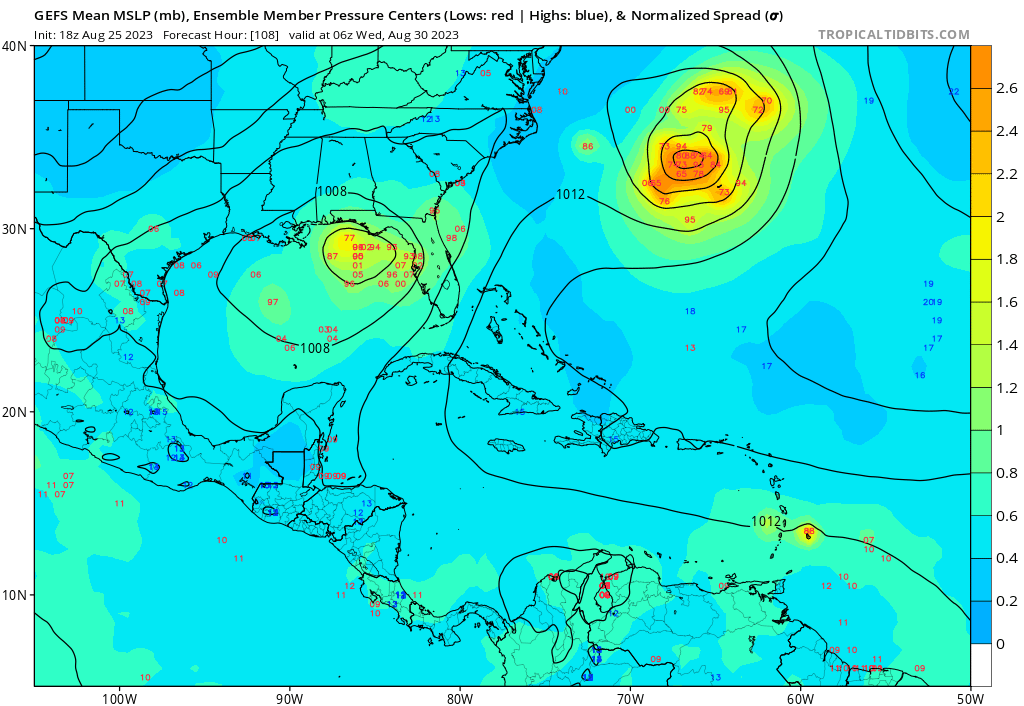
18Z GFS ensembles are in and look generally weaker but there are a number of them now which cross through the peninsula and get near or over West-Central Florida / Tampa area whereas the 12Z did not have as many of those:
1 likes
Re: ATL: INVEST 93L - Models
LarryWx wrote:For record-keeping purposes, I'm putting the last four 12 hourly UKMET runs here:
1) 8/24 0Z run:
Has a TD forming just S of W Cuba that later moves NE over S FL:
NEW TROPICAL CYCLONE FORECAST TO DEVELOP AFTER 96 HOURS
FORECAST POSITION AT T+ 96 : 22.1N 83.2W
LEAD CENTRAL MAXIMUM WIND
VERIFYING TIME TIME POSITION PRESSURE (MB) SPEED (KNOTS)
-------------- ---- -------- ------------- -------------
0000UTC 28.08.2023 96 22.1N 83.2W 1004 26
1200UTC 28.08.2023 108 23.6N 82.2W 1005 33
0000UTC 29.08.2023 120 24.9N 81.8W 1005 26
1200UTC 29.08.2023 132 27.2N 80.2W 1007 26
0000UTC 30.08.2023 144 28.2N 80.5W 1005 27
1200UTC 30.08.2023 156 30.3N 78.3W 1007 27
0000UTC 31.08.2023 168 32.1N 76.1W 1006 28
-----------------------------
2) 8/24 12Z run:
This run is significantly stronger than the 8/24 0Z run (partially due to being over water longer) with a TS instead of just a TD. Also, instead of it moving NE across S FL, it moves NE from the FL Big Bend across N FL into the Atlantic:
NEW TROPICAL CYCLONE FORECAST TO DEVELOP AFTER 72 HOURS
FORECAST POSITION AT T+ 72 : 20.9N 86.3W
LEAD CENTRAL MAXIMUM WIND
VERIFYING TIME TIME POSITION PRESSURE (MB) SPEED (KNOTS)
-------------- ---- -------- ------------- -------------
1200UTC 27.08.2023 72 20.9N 86.3W 1005 22
0000UTC 28.08.2023 84 21.2N 85.7W 1003 24
1200UTC 28.08.2023 96 22.8N 84.8W 1002 36
0000UTC 29.08.2023 108 24.8N 83.7W 1000 36
1200UTC 29.08.2023 120 27.2N 83.6W 997 38
0000UTC 30.08.2023 132 28.6N 83.4W 994 37
1200UTC 30.08.2023 144 30.3N 82.1W 994 40
0000UTC 31.08.2023 156 32.3N 79.5W 993 41
1200UTC 31.08.2023 168 34.4N 77.1W 996 39
-----------------------------
3) 8/25 0Z run:
a bit stronger than 8/24 12Z run (60 mph when goes offshore E US at end) (UKMET often conservative with winds as 990 mb usually corresponds to stronger TS than 50 mph) with similar to 8/24 12Z run but with slight NW shift. It again landfalls in the FL Big Bend and then goes NE through SE GA and then offshore from SC:
NEW TROPICAL CYCLONE FORECAST TO DEVELOP AFTER 66 HOURS
FORECAST POSITION AT T+ 66 : 21.4N 88.3W
LEAD CENTRAL MAXIMUM WIND
VERIFYING TIME TIME POSITION PRESSURE (MB) SPEED (KNOTS)
-------------- ---- -------- ------------- -------------
0000UTC 28.08.2023 72 21.3N 87.9W 1004 22
1200UTC 28.08.2023 84 23.4N 86.2W 1000 43
0000UTC 29.08.2023 96 25.1N 84.9W 996 39
1200UTC 29.08.2023 108 27.6N 84.8W 992 40
0000UTC 30.08.2023 120 29.2N 83.9W 990 43
1200UTC 30.08.2023 132 31.3N 82.0W 993 44
0000UTC 31.08.2023 144 33.1N 78.5W 991 45
1200UTC 31.08.2023 156 34.4N 74.6W 991 48
0000UTC 01.09.2023 168 35.2N 70.6W 993 52
-------------------------------
4) 8/25 12Z run (latest):
track is SE of 8/25 0Z run but still landfalls near FL Big Bend; then moves NE to off the SE US; still a TS but a bit weaker than 0Z run due maybe to the further SE track:
NEW TROPICAL CYCLONE FORECAST TO DEVELOP AFTER 84 HOURS
FORECAST POSITION AT T+ 84 : 23.2N 85.4W
LEAD CENTRAL MAXIMUM WIND
VERIFYING TIME TIME POSITION PRESSURE (MB) SPEED (KNOTS)
-------------- ---- -------- ------------- -------------
0000UTC 29.08.2023 84 23.2N 85.4W 1005 31
1200UTC 29.08.2023 96 25.8N 83.9W 1002 38
0000UTC 30.08.2023 108 28.3N 82.7W 999 32
1200UTC 30.08.2023 120 31.7N 80.4W 1000 34
0000UTC 31.08.2023 132 32.8N 77.9W 1000 35
1200UTC 31.08.2023 144 33.9N 74.5W 1000 32
0000UTC 01.09.2023 156 34.3N 71.9W 1001 39
1200UTC 01.09.2023 168 34.2N 69.2W 1002 36
Thank you for this!
Are you planning to keep it updated?
1 likes
Cleo - 1964, Betsy - 1965, David - 1979, Andrew - 1992, Charlie (Francis, Ivan, Jeanne) - 2004, Irma - 2017, Ian - 2022, Milton - 2024
-
chris_fit

- Category 5

- Posts: 3261
- Age: 43
- Joined: Wed Sep 10, 2003 11:58 pm
- Location: Tampa Bay Area, FL
Re: ATL: INVEST 93L - Models
gatorcane wrote:18Z GFS ensembles are in and look generally weaker but there are a number of them now which cross through the peninsula and get near or over West-Central Florida / Tampa area whereas the 12Z did not have as many of those:
https://i.postimg.cc/c46DRntw/gfs-ememb-lowlocs-watl-19.pngA
Noticed this as well. Almost like two camps (East and west)
0 likes
-
ElectricStorm

- Category 5
- Posts: 5139
- Age: 25
- Joined: Tue Aug 13, 2019 11:23 pm
- Location: Norman, OK
Re: ATL: INVEST 93L - Models
Hurricane models are running, HAFS-A and HAFS-B are all over the place with the LLC trying to form
0 likes
B.S Meteorology, University of Oklahoma '25
Please refer to the NHC, NWS, or SPC for official information.
Please refer to the NHC, NWS, or SPC for official information.
-
Blown Away

- S2K Supporter
- Posts: 10253
- Joined: Wed May 26, 2004 6:17 am
Re: ATL: INVEST 93L - Models
chris_fit wrote:Is there a 18z Ukmet run?
There is, it’s running now. I’ll post when it’s done.
0 likes
Hurricane Eye Experience: David 79, Irene 99, Frances 04, Jeanne 04, Wilma 05… Hurricane Brush Experience: Andrew 92, Erin 95, Floyd 99, Matthew 16, Irma 17, Ian 22, Nicole 22…

Re: ATL: INVEST 93L - Models
Salute!
For basic coords, Big Bend starts in west near St Marks and goes around the Cedar Key - so start about 84.5 and move east. Michael hit the Panhandle at about 29.9/85.4, where my sis-in-law lives.
=============
I like the easterly prediction but have seen too many storms wander about, with Elena being the cat's meow.
I was hoping for a stronger El Nino that usually dampens the Gulf storms but maybe a cold front could help us. We have a forecast for one, but it looks too late help.
Gums sends..
0 likes


Re: ATL: INVEST 93L - Models
GFS model has to gain back some respect for me to believe anything from it.
2 likes
-
ElectricStorm
- Category 5
- Posts: 5139
- Age: 25
- Joined: Tue Aug 13, 2019 11:23 pm
- Location: Norman, OK
Re: ATL: INVEST 93L - Models
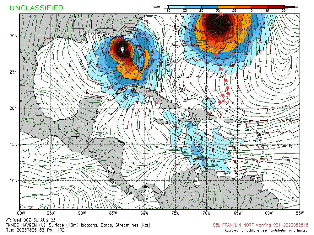
HAFS-A hour 102

0 likes
B.S Meteorology, University of Oklahoma '25
Please refer to the NHC, NWS, or SPC for official information.
Please refer to the NHC, NWS, or SPC for official information.
-
ElectricStorm
- Category 5
- Posts: 5139
- Age: 25
- Joined: Tue Aug 13, 2019 11:23 pm
- Location: Norman, OK
Re: ATL: INVEST 93L - Models
HAFS-B is way west

0 likes
B.S Meteorology, University of Oklahoma '25
Please refer to the NHC, NWS, or SPC for official information.
Please refer to the NHC, NWS, or SPC for official information.
-
gatorcane
- S2K Supporter
- Posts: 23708
- Age: 48
- Joined: Sun Mar 13, 2005 3:54 pm
- Location: Boca Raton, FL
Re: ATL: INVEST 93L - Models
18Z NAVGEM shifts left and much stronger just west of Tampa area, ends up landfalling near Cedar Key:
0 likes

Re: ATL: INVEST 93L - Models
MetroMike wrote:GFS model has to gain back some respect for me to believe anything from it.
Haha. Yeah. It had a different look at 500mb on the 12z’s tha EC though all the models I looked at were different at 500. Seems like they all depict a front coming down breaking down the ridge enough to allow an alleyway up and out through Florida. EC had the more pronounced weakness. Hopefully the heat and high pressure will migrate back west but I’m thinking it’s gonna be a hot start to September as well.
I see the intensity models ticked up a bit. Not sure there is a ceiling above a 1. You’d think something coming out of the western Caribbean end of August could potentially become a Cat 4 or 5. But they don’t see it this time. Maybe the airmass contrast isn’t as strong with 93L, but if we see a similar situation in the next several weeks, there could be higher potential.
1 likes
-
gatorcane
- S2K Supporter
- Posts: 23708
- Age: 48
- Joined: Sun Mar 13, 2005 3:54 pm
- Location: Boca Raton, FL
Re: ATL: INVEST 93L - Models
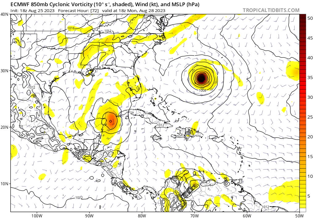
We will see what the 90 hour frame looks like but at 72 hours, the 18Z Euro is a bit more east and with a stronger vortex than the 12Z:
0 likes

Re: ATL: INVEST 93L - Models
gatorcane wrote:We will see what the 90 hour frame looks like but at 72 hours, the 18Z Euro is a bit more east and with a stronger vortex than the 12Z:
https://i.postimg.cc/y6v2KBz6/ec-fast-uv850-vort-watl-4.png
Not shocking. More east, a bit stronger, but even being a bit more east half the cir is still over land so that will hold it in check some from really taking off. Once it gets in the Gulf more it shoudl be better. Still it's 1004mb strong TD or weak TS. Like I've said before we could on the high end see an Earl type cat2 slop. I like tampa area and 85mph. I could see as far south as Englewood. Normally I wouldn't make a big deal about a storm like this, cat1 but this will not help around Here with people still waiting on roofs and even a cat1 into the area surge wise won't help as well after Ian. Here in Punta Gorda a 85mph storm at landfall would probably give us 70mph sustained, gusts to 90.
0 likes
-
cycloneye

- Admin

- Posts: 149275
- Age: 69
- Joined: Thu Oct 10, 2002 10:54 am
- Location: San Juan, Puerto Rico
Re: ATL: INVEST 93L - Models
HWRF has a hurricane tracking between FT Myers and Tampa. Run has not finished loading.

0 likes
Visit the Caribbean-Central America Weather Thread where you can find at first post web cams,radars
and observations from Caribbean basin members Click Here
and observations from Caribbean basin members Click Here
-
SunnyThoughts
- Category 5
- Posts: 2263
- Joined: Wed Jul 09, 2003 12:42 pm
- Location: Pensacola, Florida

-
ElectricStorm
- Category 5
- Posts: 5139
- Age: 25
- Joined: Tue Aug 13, 2019 11:23 pm
- Location: Norman, OK
Re: ATL: INVEST 93L - Models

0 likes
B.S Meteorology, University of Oklahoma '25
Please refer to the NHC, NWS, or SPC for official information.
Please refer to the NHC, NWS, or SPC for official information.
-
cycloneye
- Admin
- Posts: 149275
- Age: 69
- Joined: Thu Oct 10, 2002 10:54 am
- Location: San Juan, Puerto Rico
Re: ATL: INVEST 93L - Models
HWRF is HWRF doing it's thing. 959 mbs at landfall just north of Tampa.

0 likes
Visit the Caribbean-Central America Weather Thread where you can find at first post web cams,radars
and observations from Caribbean basin members Click Here
and observations from Caribbean basin members Click Here

Re: ATL: INVEST 93L - Models
i think position of the coc more east vs west over yucatán will be key if more over water and strengthens more quickly and becomes a hurricane then it should go poleward into panhandle more than peninsula. Also think heat content maybe not considered in the models as to intensity. this is a very interesting storm.
2 likes
Robbielyn McCrary
I know just about enough to sound like I know what I'm talking about sometimes. But for your safety please follow the nhc for truly professional forecasting.
I know just about enough to sound like I know what I'm talking about sometimes. But for your safety please follow the nhc for truly professional forecasting.
Re: ATL: INVEST 93L - Models
SunnyThoughts wrote:HWRF doing HWRF things.
https://www.tropicaltidbits.com/analysis/models/hwrf/2023082518/hwrf_ref_93L_33.png
Landfall around Northern Pasco County cat2. Track wise seems reasonable.
0 likes
Who is online
Users browsing this forum: No registered users and 30 guests