NWS out of Melbourne, FL
Next Week...
Undoubtedly, all eyes will be on Hurricane Lee, which is currently strengthening on its trek westward across the Tropical Atlantic. The official forecast track takes the hurricane to major status, north of Puerto Rico, by Monday night. 06/12Z grand ensemble cluster analysis is in fairly good agreement with the upper air pattern across North America through the first half of next week. It is
characterized by high-latitude ridging across north and central Canada that extends into the Southwestern United States. Downstream across the Eastern U.S., a broad trough is expected to slowly migrate from the Great Lakes to the Eastern Seaboard between Monday and Thursday. Fortunately for Florida, this pattern is nearly the opposite of the analog to landfalling hurricanes of the past. In other words, an East Coast trough configuration similar to the current forecast, more often than not, tends to cause Atlantic
hurricanes to recurve before reaching our coast. Despite varying depths to the trough among the ensemble envelope, at this time all of the clusters show that it will do the trick to cause a gradual turn north for Lee by Tuesday or Wednesday well to the east of Florida (likely northeast of 20N/70W).
Now, here is the caveat. Although guidance remains in strong
agreement with this right now, we are still talking about a forecast 6-9 days out. Changes are always possible - and this is a good reminder that we are in the peak of hurricane season. You should always have your preparedness plans and supplies in place in the event a storm threatens us. Visit weather.gov/safety/hurricane-plan.
ATL: LEE - Post-Tropical - Discussion
Moderator: S2k Moderators
-
toad strangler

- S2K Supporter

- Posts: 4546
- Joined: Sun Jul 28, 2013 3:09 pm
- Location: Earth
- Contact:
Re: ATL: LEE - Hurricane - Discussion
2 likes
My Weather Station
https://www.wunderground.com/dashboard/pws/KFLPORTS603
https://www.wunderground.com/dashboard/pws/KFLPORTS603

Re: ATL: LEE - Hurricane - Discussion
Woofde wrote:Where Lee ends up slowing down will have a huge effect on its intensity. If Lee sticks South it will have ample amounts of high energy fuel. Further North and it's more dubious.https://uploads.tapatalk-cdn.com/20230907/bf0fff16fbd1f6fa07e71668d76696b7.jpg https://uploads.tapatalk-cdn.com/20230907/fa06777786e46f639dafcf6de5744d64.jpg
Wow the cat 5 and <900 mb area in the open Atlantic has grown a lot the last few days.
1 likes
-
cycloneye

- Admin

- Posts: 149291
- Age: 69
- Joined: Thu Oct 10, 2002 10:54 am
- Location: San Juan, Puerto Rico
Re: ATL: LEE - Hurricane - Discussion
Up to 80kt.

AL, 13, 2023090712, , BEST, 0, 161N, 494W, 80, 983, HU
1 likes
Visit the Caribbean-Central America Weather Thread where you can find at first post web cams,radars
and observations from Caribbean basin members Click Here
and observations from Caribbean basin members Click Here
-
cheezyWXguy

- Category 5

- Posts: 6282
- Joined: Mon Feb 13, 2006 12:29 am
- Location: Dallas, TX
Re: ATL: LEE - Hurricane - Discussion
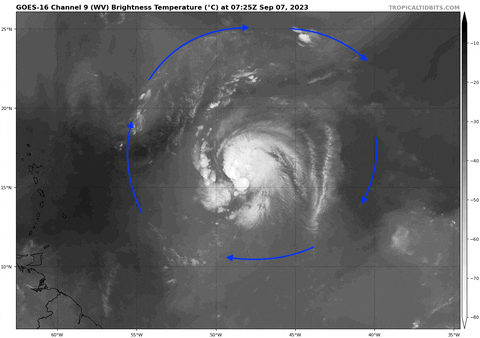
Wow, I had a feeling Lee was going to start cleaning itself up overnight, but its current satellite appearance is further along than I would have expected. Grab your snacks and head to the theater, the show is about to begin
9 likes
Re: ATL: LEE - Hurricane - Discussion
Roughly 10 - 11 more hours until the first recon reaches Lee. The way things are going I'm convinced it's gonna find a MH.
1 likes
-
ThunderForce

- Tropical Storm

- Posts: 208
- Age: 26
- Joined: Tue Sep 27, 2022 6:20 pm
- Location: Calhoun County, Florida
Re: ATL: LEE - Hurricane - Discussion
I honestly can't tell if Lee is moving northward at all at the moment. It looks like a west or north of due west movement.
1 likes
Please refer to the NWS, NHC, SPC or a professional meteorologist for information and decision making during storms.
-
REDHurricane

- Category 1

- Posts: 438
- Age: 28
- Joined: Sun Jul 03, 2022 2:36 pm
- Location: Northeast Pacific Ocean

-
Category5Kaiju

- Category 5
- Posts: 4331
- Joined: Thu Dec 24, 2020 12:45 pm
- Location: Seattle and Phoenix
Re: ATL: LEE - Hurricane - Discussion
kevin wrote:Roughly 10 - 11 more hours until the first recon reaches Lee. The way things are going I'm convinced it's gonna find a MH.
At this point I think it's probably at least a Category 2.
1 likes
Unless explicitly stated, all info in my posts is based on my own opinions and observations. Tropical storms and hurricanes can be extremely dangerous. Refer to an accredited weather research agency or meteorologist if you need to make serious decisions regarding an approaching storm.
Re: ATL: LEE - Hurricane - Discussion
Looks like a potent hurricane on its way to a MH. Crazy how much it has improved in the last 6 hours or so.

8 likes
-
KirbyDude25

- Tropical Storm
- Posts: 161
- Age: 20
- Joined: Mon Sep 20, 2021 8:03 am
- Location: Westfield, New Jersey
Re: ATL: LEE - Hurricane - Discussion
Category5Kaiju wrote:kevin wrote:Roughly 10 - 11 more hours until the first recon reaches Lee. The way things are going I'm convinced it's gonna find a MH.
At this point I think it's probably at least a Category 2.
Given that the 12Z Best Track had this at 80 knots and it's likely strengthened a bit in the hour since, 85 knots is probably a reasonable estimate for its current intensity. I predict that the NHC's 11 AM advisory will have Lee at 85-90 knots, possibly 95. I agree with above comments that tonight's recon will likely find a major.
0 likes
New Jersey, Rutgers '27
Irene 2011 | Sandy 2012 | Fay 2020 | Isaias 2020 | Ida 2021
Irene 2011 | Sandy 2012 | Fay 2020 | Isaias 2020 | Ida 2021
-
Iceresistance

- Category 5
- Posts: 9579
- Age: 22
- Joined: Sat Oct 10, 2020 9:45 am
- Location: Tecumseh, OK/Norman, OK
Re: ATL: LEE - Hurricane - Discussion
Has anyone noticed that the NHC is forecasting Lee to peak at 155 mph already?
FORECAST POSITIONS AND MAX WINDS
INIT 07/0900Z 16.1N 48.6W 70 KT 80 MPH
12H 07/1800Z 16.8N 50.3W 85 KT 100 MPH
24H 08/0600Z 17.8N 52.7W 100 KT 115 MPH
36H 08/1800Z 18.8N 55.0W 115 KT 130 MPH
48H 09/0600Z 19.8N 57.1W 125 KT 145 MPH
60H 09/1800Z 20.6N 59.1W 135 KT 155 MPH
72H 10/0600Z 21.3N 60.7W 135 KT 155 MPH
96H 11/0600Z 22.5N 63.6W 125 KT 145 MPH
120H 12/0600Z 23.5N 65.9W 115 KT 130 MPH
2 likes
Bill 2015 & Beta 2020
Winter 2020-2021
All observations are in Tecumseh, OK unless otherwise noted.
Winter posts are focused mainly for Oklahoma & Texas.
Take any of my forecasts with a grain of salt, refer to the NWS, SPC, and NHC for official information
Never say Never with weather! Because ANYTHING is possible!
Winter 2020-2021
All observations are in Tecumseh, OK unless otherwise noted.
Winter posts are focused mainly for Oklahoma & Texas.
Take any of my forecasts with a grain of salt, refer to the NWS, SPC, and NHC for official information
Never say Never with weather! Because ANYTHING is possible!
-
REDHurricane
- Category 1
- Posts: 438
- Age: 28
- Joined: Sun Jul 03, 2022 2:36 pm
- Location: Northeast Pacific Ocean


-
Iceresistance
- Category 5
- Posts: 9579
- Age: 22
- Joined: Sat Oct 10, 2020 9:45 am
- Location: Tecumseh, OK/Norman, OK
Re: ATL: LEE - Hurricane - Discussion

4 likes
Bill 2015 & Beta 2020
Winter 2020-2021
All observations are in Tecumseh, OK unless otherwise noted.
Winter posts are focused mainly for Oklahoma & Texas.
Take any of my forecasts with a grain of salt, refer to the NWS, SPC, and NHC for official information
Never say Never with weather! Because ANYTHING is possible!
Winter 2020-2021
All observations are in Tecumseh, OK unless otherwise noted.
Winter posts are focused mainly for Oklahoma & Texas.
Take any of my forecasts with a grain of salt, refer to the NWS, SPC, and NHC for official information
Never say Never with weather! Because ANYTHING is possible!
-
SouthFLTropics

- Category 5
- Posts: 4258
- Age: 50
- Joined: Thu Aug 14, 2003 8:04 am
- Location: Port St. Lucie, Florida
Re: ATL: LEE - Hurricane - Discussion
It never ceases to amaze me how potent one of these things can get when all the pieces of the puzzle are just right at the right time. Fortunately, we haven't seen a dramatic case of this having a direct impact on a land area recently. I have to think that what we are about to see with Lee is similar to what happened with the 1935 Labor Day Hurricane, except that happened in the Florida Straits and left the Keys in a very bad position.
7 likes
Fourth Generation Florida Native
Personal Storm History: David 79, Andrew 92, Erin 95, Floyd 99, Irene 99, Frances 04, Jeanne 04, Wilma 05, Matthew 16, Irma 17, Ian 22, Nicole 22, Milton 24
Personal Storm History: David 79, Andrew 92, Erin 95, Floyd 99, Irene 99, Frances 04, Jeanne 04, Wilma 05, Matthew 16, Irma 17, Ian 22, Nicole 22, Milton 24
-
ScottNAtlanta

- Category 5
- Posts: 2535
- Joined: Sat May 25, 2013 3:11 pm
- Location: Atlanta, GA
Re: ATL: LEE - Hurricane - Discussion
This video was posted on YouTube by Bernie Rayno at Accuweather last night and the gist of it is if the trough is weaker and further east (flatter) it will pick it up. If is is strong and deep it might not.
https://youtu.be/D6fNjCRSTxo?si=CwR7t5Rl42WCkXuU
I tried to embed it but couldn't figure it out
https://youtu.be/D6fNjCRSTxo?si=CwR7t5Rl42WCkXuU
I tried to embed it but couldn't figure it out
0 likes
The posts in this forum are NOT official forecast and should not be used as such. They are just the opinion of the poster and may or may not be backed by sound meteorological data. They are NOT endorsed by any professional institution or storm2k.org. For official information, please refer to the NHC and NWS products.
-
TallyTracker
- Category 2

- Posts: 787
- Joined: Thu Oct 11, 2018 2:46 pm
Re: ATL: LEE - Hurricane - Discussion
REDHurricane wrote:4 hours ago:
https://i.ibb.co/SsmWsfL/0eedaddf-c7f0-4dd6-8c67-8ffb3b214fa6.jpg
Now:
https://i.ibb.co/fGRCNZW/467e091f-b9fd-4c89-a3d4-e575cdf2692d.jpg
The NE shear is clearly gone now. That’s very rapid improvement. I concur with everyone else. Rapid deepening has commenced!
2 likes
Fran '96, Georges '98, Gordon '00, Gabrielle '01, Charley '04, Frances '04, Jeanne '04, Barry '07, Fay '08, Debby '12, Matthew '16, Emily '17, Irma '17, Michael ‘18, Elsa ‘21, Fred ‘21, Mindy ‘21, Nicole ‘22, Idalia ‘23, Debby ‘24, Helene ‘24
-
cycloneye
- Admin
- Posts: 149291
- Age: 69
- Joined: Thu Oct 10, 2002 10:54 am
- Location: San Juan, Puerto Rico
Re: ATL: LEE - Hurricane - Discussion

3 likes
Visit the Caribbean-Central America Weather Thread where you can find at first post web cams,radars
and observations from Caribbean basin members Click Here
and observations from Caribbean basin members Click Here
-
InfernoFlameCat

- Category 5
- Posts: 2127
- Age: 22
- Joined: Mon Dec 14, 2020 10:52 am
- Location: Buford, GA
Re: ATL: LEE - Hurricane - Discussion
What a storm this will become. I think it will look better than Sam.
1 likes
I am by no means a professional. DO NOT look at my forecasts for official information or make decisions based on what I post.
Goal: to become a registered expert over tropical and subtropical cyclones.
Goal: to become a registered expert over tropical and subtropical cyclones.
-
cheezyWXguy
- Category 5
- Posts: 6282
- Joined: Mon Feb 13, 2006 12:29 am
- Location: Dallas, TX
Re: ATL: LEE - Hurricane - Discussion
That is a textbook fist on satellite. I’d guess Lee is probably near 90kt right now
2 likes

Re: ATL: LEE - Hurricane - Discussion
kevin wrote:Roughly 10 - 11 more hours until the first recon reaches Lee. The way things are going I'm convinced it's gonna find a MH.
It’ll likely find a Cat 4 the way things are going this morning.
Lee is ahead of that HAFS-B run from yesterday that made it a sub-900 Cat 5. We’re gonna be in for a wild ride.
6 likes
Irene '11 Sandy '12 Hermine '16 5/15/2018 Derecho Fay '20 Isaias '20 Elsa '21 Henri '21 Ida '21
I am only a meteorology enthusiast who knows a decent amount about tropical cyclones. Look to the professional mets, the NHC, or your local weather office for the best information.
I am only a meteorology enthusiast who knows a decent amount about tropical cyclones. Look to the professional mets, the NHC, or your local weather office for the best information.
Who is online
Users browsing this forum: No registered users and 17 guests