Below is a copy of a post I did 10/1/22 detailing Ian FL LF progs for 5 main op models starting from 0Z 9/25 runs, which were then 85 hours out from the Port Charlotte LF. As of 0Z today, Idalia was only ~60 hours from landfall. So, that would about correspond to the 0Z 9/26 runs for Ian.
So, one can see from this that:
A. -Top performing UKMET <50 miles from actual Ian LF all runs within 85 hours. ~Spot on for runs that were 85, 61, 49, and 13 hours out with little net bias.
-2nd best ICON even had Tampa (70 miles too far left) just 49 hours out
-CMC was still way too far left just 25 hrs out!
-GFS not close til 25 hrs out
-Euro not close til 37 hrs out
B. Per 0Z 9/26 Ian runs, which correspond to ~how far from LF is Idalia as of 0Z today (~60 hours):
1) UKMET was spot on and ICON only 25 miles too far left
2) CMC and GFS were way up at Apalachee Bay, a whopping 250 miles too far left
3) Euro was up at Cedar Key, 160 miles too far left
4) So, non-UKMET models were all too far left with GFS, CMC, and Euro a whopping 160-250 miles too far left
5) For Idalia, models are way closer together for LF at ~60 hour point (0Z 8/28 runs):
-GFS/CMC furthest left near Perry
-ICON furthest right ~10 miles SE of Cedar Key
-So, range is only 75 miles vs 250 miles for Ian at same time from LF! GFS/CMC are furthest left like for Ian but not nearly by as much
-UKMET/Euro right in middle ~30 miles NW of Cedar Key
-Based on this, I'm guessing that 0Z GFS/CMC at Perry will verify too far left
-My best guess is to go close to 0Z UKMET/Euro, which were ~30 miles NW of Cedar Key and ~40 miles NW of 0Z ICON
---------------------------------
Here's the Ian FL landfall model performance post I made last year:
"Looking back to the 0Z 9/25 runs at where the models had FL landfalls:
0Z 9/25:
ICON Venice
CMC Cedar Key
GFS Destin
Euro Sarasota
UKMET Port Charlotte
12Z 9/25:
ICON Sarasota
CMC Apalachee Bay
GFS Apalachee Bay
Euro Tampa
UKMET Venice
0Z 9/26:
ICON Venice
CMC Apalachee Bay
GFS Apalachee Bay
Euro Cedar Key
UKMET Port Charlotte
12Z 9/26:
ICON Tampa
CMC Apalachicola
GFS Tampa
Euro Big Bend
UKMET Port Charlotte
0Z 9/27:
ICON Venice
CMC Big Bend
GFS Sarasota
Euro Venice
UKMET just N of Ft Myers
12Z 9/27:
ICON Port Charlotte
CMC Tampa
GFS just N of Port Charlotte
Euro Port Charlotte
UKMET 20 miles S of Ft. Myers
0Z 9/28:
ICON 15 miles S of Port Charlotte
CMC Venice
GFS Port Charlotte
Euro Port Charlotte
UKMET Port Charlotte
My grades on FL landfall only (i.e., excluding SC landfall) for 9/25-8 runs:
UKMET A-
ICON B
Euro C-
GFS D
CMC F"
ATL: IDALIA - Models
Moderator: S2k Moderators
Re: ATL: IDALIA - Models
9 likes
Personal Forecast Disclaimer:
The posts in this forum are NOT official forecasts and should not be used as such. They are just the opinion of the poster and may or may not be backed by sound meteorological data. They are NOT endorsed by any professional institution or storm2k.org. For official information, please refer to the NHC and NWS products.
The posts in this forum are NOT official forecasts and should not be used as such. They are just the opinion of the poster and may or may not be backed by sound meteorological data. They are NOT endorsed by any professional institution or storm2k.org. For official information, please refer to the NHC and NWS products.
-
Blown Away

- S2K Supporter

- Posts: 10253
- Joined: Wed May 26, 2004 6:17 am
Re: ATL: IDALIA - Models
12z ICON
0 likes
Hurricane Eye Experience: David 79, Irene 99, Frances 04, Jeanne 04, Wilma 05… Hurricane Brush Experience: Andrew 92, Erin 95, Floyd 99, Matthew 16, Irma 17, Ian 22, Nicole 22…
-
tolakram
- Admin

- Posts: 20179
- Age: 62
- Joined: Sun Aug 27, 2006 8:23 pm
- Location: Florence, KY (name is Mark)
Re: ATL: IDALIA - Models
ICON sticking extremely close to the same landfall position.

0 likes
M a r k
- - - - -
Join us in chat: Storm2K Chatroom Invite. Android and IOS apps also available.
The posts in this forum are NOT official forecasts and should not be used as such. Posts are NOT endorsed by any professional institution or STORM2K.org. For official information and forecasts, please refer to NHC and NWS products.
-
SouthFLTropics

- Category 5

- Posts: 4258
- Age: 50
- Joined: Thu Aug 14, 2003 8:04 am
- Location: Port St. Lucie, Florida
Re: ATL: IDALIA - Models
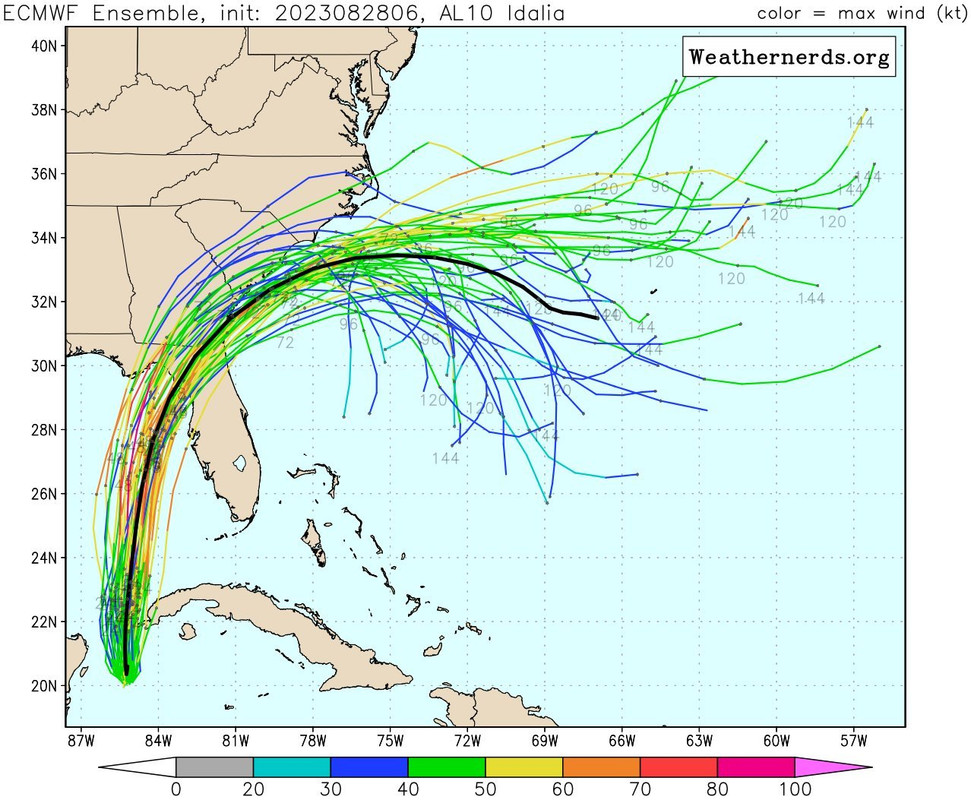
Obviously the immediate concern is for the Florida Gulf Coast. Based on some of the recent model runs though, I'm beginning to be concerned about the possibility of Idalia getting trapped off of the SE US coastline. GFS has shown this for two runs in a row now and the Euro ensembles had many members showing her looping south.
4 likes
Fourth Generation Florida Native
Personal Storm History: David 79, Andrew 92, Erin 95, Floyd 99, Irene 99, Frances 04, Jeanne 04, Wilma 05, Matthew 16, Irma 17, Ian 22, Nicole 22, Milton 24
Personal Storm History: David 79, Andrew 92, Erin 95, Floyd 99, Irene 99, Frances 04, Jeanne 04, Wilma 05, Matthew 16, Irma 17, Ian 22, Nicole 22, Milton 24
Re: ATL: IDALIA - Models
GFS has the remnants of Idalia pulling an Ivan and looping back SW once it comes off the coast of the Carolinas.
0 likes
-
chris_fit

- Category 5
- Posts: 3261
- Age: 43
- Joined: Wed Sep 10, 2003 11:58 pm
- Location: Tampa Bay Area, FL
Re: ATL: IDALIA - Models
IF I'm reading this right.... UKMET with a pretty large shift to the West.
MET OFFICE TROPICAL CYCLONE GUIDANCE FOR NORTH-EAST PACIFIC
AND ATLANTIC
GLOBAL MODEL DATA TIME 12UTC 28.08.2023
TROPICAL STORM IDALIA ANALYSED POSITION : 20.6N 85.4W
ATCF IDENTIFIER : AL102023
VERIFYING TIME POSITION STRENGTH TENDENCY
-------------- -------- -------- --------
12UTC 28.08.2023 20.6N 85.4W MODERATE
00UTC 29.08.2023 21.5N 85.4W MODERATE LITTLE CHANGE
12UTC 29.08.2023 23.3N 85.8W MODERATE LITTLE CHANGE
00UTC 30.08.2023 25.3N 86.0W MODERATE LITTLE CHANGE
12UTC 30.08.2023 27.7N 85.3W MODERATE LITTLE CHANGE
00UTC 31.08.2023 30.2N 84.1W MODERATE INTENSIFYING SLIGHTLY
12UTC 31.08.2023 32.6N 81.8W MODERATE WEAKENING SLIGHTLY
00UTC 01.09.2023 33.6N 78.7W MODERATE WEAKENING SLIGHTLY
12UTC 01.09.2023 34.5N 75.3W WEAK LITTLE CHANGE
00UTC 02.09.2023 34.0N 72.7W WEAK LITTLE CHANGE
12UTC 02.09.2023 34.9N 70.4W WEAK LITTLE CHANGE
00UTC 03.09.2023 37.0N 66.5W WEAK LITTLE CHANGE
12UTC 03.09.2023 36.8N 64.9W WEAK LITTLE CHANGE
00UTC 04.09.2023 37.2N 62.1W MODERATE INTENSIFYING SLIGHTLY
12UTC 04.09.2023 38.9N 59.8W MODERATE INTENSIFYING SLIGHTLY
2 likes
-
SunnyThoughts
- Category 5
- Posts: 2263
- Joined: Wed Jul 09, 2003 12:42 pm
- Location: Pensacola, Florida
Re: ATL: IDALIA - Models
SouthFLTropics wrote:Obviously the immediate concern is for the Florida Gulf Coast. Based on some of the recent model runs though, I'm beginning to be concerned about the possibility of Idalia getting trapped off of the SE US coastline. GFS has shown this for two runs in a row now and the Euro ensembles had many members showing her looping south.
Yes, I'm watching the GFS run now...at hour 162, the remnants of Idalia sitting right off the coast on the Atlantic side of Florida peninsula, after circling around. Interesting.
0 likes
Re: ATL: IDALIA - Models
chris_fit wrote:IF I'm reading this right.... UKMET with a pretty large shift to the West.MET OFFICE TROPICAL CYCLONE GUIDANCE FOR NORTH-EAST PACIFIC
AND ATLANTIC
GLOBAL MODEL DATA TIME 12UTC 28.08.2023
TROPICAL STORM IDALIA ANALYSED POSITION : 20.6N 85.4W
ATCF IDENTIFIER : AL102023
VERIFYING TIME POSITION STRENGTH TENDENCY
-------------- -------- -------- --------
12UTC 28.08.2023 20.6N 85.4W MODERATE
00UTC 29.08.2023 21.5N 85.4W MODERATE LITTLE CHANGE
12UTC 29.08.2023 23.3N 85.8W MODERATE LITTLE CHANGE
00UTC 30.08.2023 25.3N 86.0W MODERATE LITTLE CHANGE
12UTC 30.08.2023 27.7N 85.3W MODERATE LITTLE CHANGE
00UTC 31.08.2023 30.2N 84.1W MODERATE INTENSIFYING SLIGHTLY
12UTC 31.08.2023 32.6N 81.8W MODERATE WEAKENING SLIGHTLY
00UTC 01.09.2023 33.6N 78.7W MODERATE WEAKENING SLIGHTLY
12UTC 01.09.2023 34.5N 75.3W WEAK LITTLE CHANGE
00UTC 02.09.2023 34.0N 72.7W WEAK LITTLE CHANGE
12UTC 02.09.2023 34.9N 70.4W WEAK LITTLE CHANGE
00UTC 03.09.2023 37.0N 66.5W WEAK LITTLE CHANGE
12UTC 03.09.2023 36.8N 64.9W WEAK LITTLE CHANGE
00UTC 04.09.2023 37.2N 62.1W MODERATE INTENSIFYING SLIGHTLY
12UTC 04.09.2023 38.9N 59.8W MODERATE INTENSIFYING SLIGHTLY
That's a huge change. I've said panhandle/western cedar key all along, nhc came back to me today
0 likes

Re: ATL: IDALIA - Models
00UTC 31.08.2023 30.2N 84.1W MODERATE INTENSIFYING SLIGHTLY
Oof that's right at the St. Marks lighthouse. Apex of Apalachee Bay. No major hurricane has thread the needle to that location.
Oof that's right at the St. Marks lighthouse. Apex of Apalachee Bay. No major hurricane has thread the needle to that location.
chris_fit wrote:IF I'm reading this right.... UKMET with a pretty large shift to the West.MET OFFICE TROPICAL CYCLONE GUIDANCE FOR NORTH-EAST PACIFIC
AND ATLANTIC
GLOBAL MODEL DATA TIME 12UTC 28.08.2023
TROPICAL STORM IDALIA ANALYSED POSITION : 20.6N 85.4W
ATCF IDENTIFIER : AL102023
VERIFYING TIME POSITION STRENGTH TENDENCY
-------------- -------- -------- --------
12UTC 28.08.2023 20.6N 85.4W MODERATE
00UTC 29.08.2023 21.5N 85.4W MODERATE LITTLE CHANGE
12UTC 29.08.2023 23.3N 85.8W MODERATE LITTLE CHANGE
00UTC 30.08.2023 25.3N 86.0W MODERATE LITTLE CHANGE
12UTC 30.08.2023 27.7N 85.3W MODERATE LITTLE CHANGE
00UTC 31.08.2023 30.2N 84.1W MODERATE INTENSIFYING SLIGHTLY
12UTC 31.08.2023 32.6N 81.8W MODERATE WEAKENING SLIGHTLY
00UTC 01.09.2023 33.6N 78.7W MODERATE WEAKENING SLIGHTLY
12UTC 01.09.2023 34.5N 75.3W WEAK LITTLE CHANGE
00UTC 02.09.2023 34.0N 72.7W WEAK LITTLE CHANGE
12UTC 02.09.2023 34.9N 70.4W WEAK LITTLE CHANGE
00UTC 03.09.2023 37.0N 66.5W WEAK LITTLE CHANGE
12UTC 03.09.2023 36.8N 64.9W WEAK LITTLE CHANGE
00UTC 04.09.2023 37.2N 62.1W MODERATE INTENSIFYING SLIGHTLY
12UTC 04.09.2023 38.9N 59.8W MODERATE INTENSIFYING SLIGHTLY
0 likes
Re: ATL: IDALIA - Models
tallywx wrote:00UTC 31.08.2023 30.2N 84.1W MODERATE INTENSIFYING SLIGHTLY
Oof that's right at the St. Marks lighthouse. Apex of Apalachee Bay. No major hurricane has thread the needle to that location.chris_fit wrote:IF I'm reading this right.... UKMET with a pretty large shift to the West.MET OFFICE TROPICAL CYCLONE GUIDANCE FOR NORTH-EAST PACIFIC
AND ATLANTIC
GLOBAL MODEL DATA TIME 12UTC 28.08.2023
TROPICAL STORM IDALIA ANALYSED POSITION : 20.6N 85.4W
ATCF IDENTIFIER : AL102023
VERIFYING TIME POSITION STRENGTH TENDENCY
-------------- -------- -------- --------
12UTC 28.08.2023 20.6N 85.4W MODERATE
00UTC 29.08.2023 21.5N 85.4W MODERATE LITTLE CHANGE
12UTC 29.08.2023 23.3N 85.8W MODERATE LITTLE CHANGE
00UTC 30.08.2023 25.3N 86.0W MODERATE LITTLE CHANGE
12UTC 30.08.2023 27.7N 85.3W MODERATE LITTLE CHANGE
00UTC 31.08.2023 30.2N 84.1W MODERATE INTENSIFYING SLIGHTLY
12UTC 31.08.2023 32.6N 81.8W MODERATE WEAKENING SLIGHTLY
00UTC 01.09.2023 33.6N 78.7W MODERATE WEAKENING SLIGHTLY
12UTC 01.09.2023 34.5N 75.3W WEAK LITTLE CHANGE
00UTC 02.09.2023 34.0N 72.7W WEAK LITTLE CHANGE
12UTC 02.09.2023 34.9N 70.4W WEAK LITTLE CHANGE
00UTC 03.09.2023 37.0N 66.5W WEAK LITTLE CHANGE
12UTC 03.09.2023 36.8N 64.9W WEAK LITTLE CHANGE
00UTC 04.09.2023 37.2N 62.1W MODERATE INTENSIFYING SLIGHTLY
12UTC 04.09.2023 38.9N 59.8W MODERATE INTENSIFYING SLIGHTLY
Indeed, the 12Z UKMET landfalls ~65 miles to the NW (at Apalachee Bay) of 0Z, which was ~30 miles NW of Cedar Key
Last edited by LarryWx on Mon Aug 28, 2023 11:35 am, edited 1 time in total.
0 likes
Personal Forecast Disclaimer:
The posts in this forum are NOT official forecasts and should not be used as such. They are just the opinion of the poster and may or may not be backed by sound meteorological data. They are NOT endorsed by any professional institution or storm2k.org. For official information, please refer to the NHC and NWS products.
The posts in this forum are NOT official forecasts and should not be used as such. They are just the opinion of the poster and may or may not be backed by sound meteorological data. They are NOT endorsed by any professional institution or storm2k.org. For official information, please refer to the NHC and NWS products.
-
SouthFLTropics
- Category 5
- Posts: 4258
- Age: 50
- Joined: Thu Aug 14, 2003 8:04 am
- Location: Port St. Lucie, Florida
Re: ATL: IDALIA - Models
If the GFS is correct, we are going to be dealing with Idalia or her remnants well into next week. Talk about adding insult to injury.
0 likes
Fourth Generation Florida Native
Personal Storm History: David 79, Andrew 92, Erin 95, Floyd 99, Irene 99, Frances 04, Jeanne 04, Wilma 05, Matthew 16, Irma 17, Ian 22, Nicole 22, Milton 24
Personal Storm History: David 79, Andrew 92, Erin 95, Floyd 99, Irene 99, Frances 04, Jeanne 04, Wilma 05, Matthew 16, Irma 17, Ian 22, Nicole 22, Milton 24
-
chris_fit
- Category 5
- Posts: 3261
- Age: 43
- Joined: Wed Sep 10, 2003 11:58 pm
- Location: Tampa Bay Area, FL
Re: ATL: IDALIA - Models
She's not supposed to cross 85W until tomorrow at about this time.... something to monitor to see which side of that (or spot on) she's on.
1 likes
-
chris_fit
- Category 5
- Posts: 3261
- Age: 43
- Joined: Wed Sep 10, 2003 11:58 pm
- Location: Tampa Bay Area, FL
Re: ATL: IDALIA - Models
Hurricane Models starting to run - Let's see if the W trends continue...
HAFS-A and HAFS-B starting up....


HAFS-A and HAFS-B starting up....
0 likes
-
SFLcane

- S2K Supporter
- Posts: 10281
- Age: 48
- Joined: Sat Jun 05, 2010 1:44 pm
- Location: Lake Worth Florida
Re: ATL: IDALIA - Models
SouthFLTropics wrote:If the GFS is correct, we are going to be dealing with Idalia or her remnants well into next week. Talk about adding insult to injury.
Yup, lets do it again this time for the eastcoast.

1 likes
Re: ATL: IDALIA - Models
With 12Z Euro still remaining, three 12Z runs shifted left vs their respective 0Z runs (UKMET, ICON, and the already tied for most left at 0Z run GFS) and one shifted right (the tied for furthest left at 0Z run CMC).
Last edited by LarryWx on Mon Aug 28, 2023 11:46 am, edited 1 time in total.
0 likes
Personal Forecast Disclaimer:
The posts in this forum are NOT official forecasts and should not be used as such. They are just the opinion of the poster and may or may not be backed by sound meteorological data. They are NOT endorsed by any professional institution or storm2k.org. For official information, please refer to the NHC and NWS products.
The posts in this forum are NOT official forecasts and should not be used as such. They are just the opinion of the poster and may or may not be backed by sound meteorological data. They are NOT endorsed by any professional institution or storm2k.org. For official information, please refer to the NHC and NWS products.
Re: ATL: IDALIA - Models
Ridge building in east of Florida could block Idalia's exit once she leaves the Carolinas.
0 likes
-
FLLurker32
- Tropical Storm

- Posts: 245
- Joined: Mon Aug 29, 2016 10:31 am
Re: ATL: IDALIA - Models
chris_fit wrote:She's not supposed to cross 85W until tomorrow at about this time.... something to monitor to see which side of that (or spot on) she's on.
I was just looking at that. 25N 85W is a big plot to watch in the angle it takes.
0 likes
Heather

Re: ATL: IDALIA - Models
IcyTundra wrote:Ridge building in east of Florida could block Idalia's exit once she leaves the Carolinas.
Maybe this is like Ivan in 2004? Loops around and it will hit SEFL and go back into the Gulf eventually??
1 likes
-
SouthFLTropics
- Category 5
- Posts: 4258
- Age: 50
- Joined: Thu Aug 14, 2003 8:04 am
- Location: Port St. Lucie, Florida
Re: ATL: IDALIA - Models
12z HAFS-B bombing out, sub 930 into Upper big bend area.
0 likes
Fourth Generation Florida Native
Personal Storm History: David 79, Andrew 92, Erin 95, Floyd 99, Irene 99, Frances 04, Jeanne 04, Wilma 05, Matthew 16, Irma 17, Ian 22, Nicole 22, Milton 24
Personal Storm History: David 79, Andrew 92, Erin 95, Floyd 99, Irene 99, Frances 04, Jeanne 04, Wilma 05, Matthew 16, Irma 17, Ian 22, Nicole 22, Milton 24
Who is online
Users browsing this forum: No registered users and 74 guests