ATL: IDALIA - Models

Moderator: S2k Moderators

Message
Author
User avatar
eastcoastFL
Category 5
Category 5
Posts: 3438
Age: 42
Joined: Thu Apr 12, 2007 12:29 pm
Location: Palm City, FL

Re: ATL: IDALIA - Models

#741 Postby eastcoastFL » Mon Aug 28, 2023 12:51 pm

chris_fit wrote:All I gotta say is, as a resident just south of Tampa. I'm grateful for these model trends.

The only thing concerning me at the moment is what she's actually doing... wobbling to the right it seems. Already right of the track and most models....

Red circle is where HH found the center just a few moments ago.

https://i.imgur.com/eU6zJlj.png


Are you sure that was a center fix?
1 likes   
Personal Forecast Disclaimer:
The posts in this forum are NOT official forecast and should not be used as such. They are just the opinion of the poster and may or may not be backed by sound meteorological data. They are NOT endorsed by any professional institution or storm2k.org. For official information, please refer to the NHC and NWS products.

User avatar
Steve
S2K Supporter
S2K Supporter
Posts: 8610
Joined: Sat Apr 05, 2003 11:41 pm
Location: Not a state-caster

Re: ATL: IDALIA - Models

#742 Postby Steve » Mon Aug 28, 2023 12:54 pm

SouthFLTropics wrote:12z HAFS-B bombing out, sub 930 into Upper big bend area.


Historic **** there - going against the grain.
Last edited by Steve on Mon Aug 28, 2023 12:54 pm, edited 1 time in total.
0 likes   

User avatar
chris_fit
Category 5
Category 5
Posts: 3078
Joined: Wed Sep 10, 2003 11:58 pm
Location: Tampa Bay Area, FL
Contact:

Re: ATL: IDALIA - Models

#743 Postby chris_fit » Mon Aug 28, 2023 12:54 pm

eastcoastFL wrote:
chris_fit wrote:All I gotta say is, as a resident just south of Tampa. I'm grateful for these model trends.

The only thing concerning me at the moment is what she's actually doing... wobbling to the right it seems. Already right of the track and most models....

Red circle is where HH found the center just a few moments ago.

https://i.imgur.com/eU6zJlj.png


Are you sure that was a center fix?


Yup

Image
1 likes   

User avatar
chris_fit
Category 5
Category 5
Posts: 3078
Joined: Wed Sep 10, 2003 11:58 pm
Location: Tampa Bay Area, FL
Contact:

Re: ATL: IDALIA - Models

#744 Postby chris_fit » Mon Aug 28, 2023 12:56 pm

Here we go...

Image
0 likes   

User avatar
chris_fit
Category 5
Category 5
Posts: 3078
Joined: Wed Sep 10, 2003 11:58 pm
Location: Tampa Bay Area, FL
Contact:

Re: ATL: IDALIA - Models

#745 Postby chris_fit » Mon Aug 28, 2023 12:58 pm

Image
0 likes   

User avatar
stormhunter7
Category 2
Category 2
Posts: 733
Joined: Mon May 26, 2008 3:13 pm
Location: Panama City Beach, Florida
Contact:

Re: ATL: IDALIA - Models

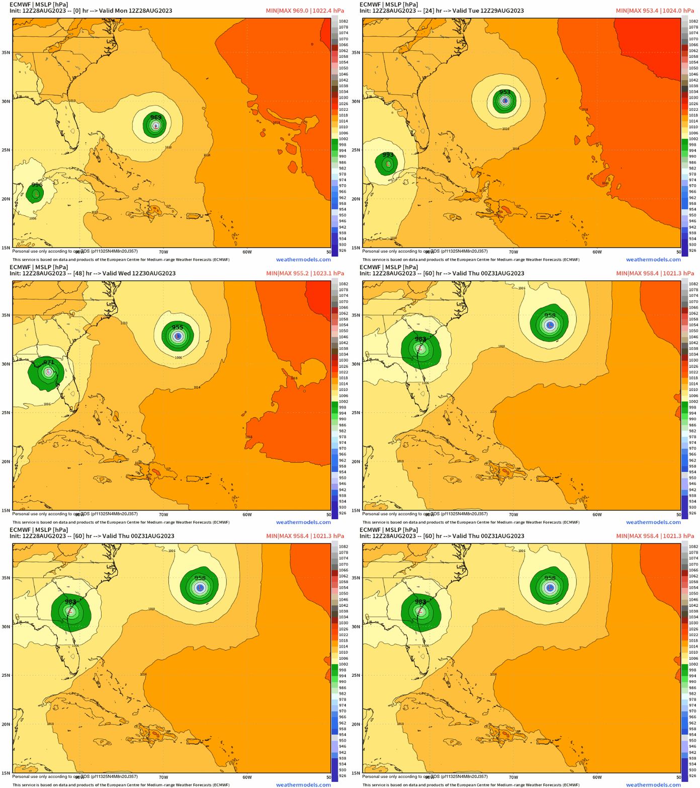
#746 Postby stormhunter7 » Mon Aug 28, 2023 1:00 pm

12z Euro a little slower and left through 48 hours, with landfall further north up the big bend coast?
0 likes   
The following post is NOT an official forecast and should not be used as such. It is just the opinion of the poster and may or may not be backed by sound meteorological data. It is NOT endorsed by any professional institution including storm2k.org For Official Information please refer to the NHC and NWS products. http://www.nhc.noaa.gov

tolakram
Admin
Admin
Posts: 19182
Age: 60
Joined: Sun Aug 27, 2006 8:23 pm
Location: Florence, KY (name is Mark)

Re: ATL: IDALIA - Models

#747 Postby tolakram » Mon Aug 28, 2023 1:04 pm

UK, west of previous run

Image

Image
0 likes   
M a r k
- - - - -
Join us in chat: Storm2K Chatroom Invite. Android and IOS apps also available.

The posts in this forum are NOT official forecasts and should not be used as such. Posts are NOT endorsed by any professional institution or STORM2K.org. For official information and forecasts, please refer to NHC and NWS products.

tolakram
Admin
Admin
Posts: 19182
Age: 60
Joined: Sun Aug 27, 2006 8:23 pm
Location: Florence, KY (name is Mark)

Re: ATL: IDALIA - Models

#748 Postby tolakram » Mon Aug 28, 2023 1:06 pm

Image
0 likes   
M a r k
- - - - -
Join us in chat: Storm2K Chatroom Invite. Android and IOS apps also available.

The posts in this forum are NOT official forecasts and should not be used as such. Posts are NOT endorsed by any professional institution or STORM2K.org. For official information and forecasts, please refer to NHC and NWS products.

User avatar
chris_fit
Category 5
Category 5
Posts: 3078
Joined: Wed Sep 10, 2003 11:58 pm
Location: Tampa Bay Area, FL
Contact:

Re: ATL: IDALIA - Models

#749 Postby chris_fit » Mon Aug 28, 2023 1:06 pm

Euro also slightly Left!

Image
0 likes   

LarryWx
Category 5
Category 5
Posts: 5795
Joined: Sun Sep 07, 2003 2:04 pm
Location: GA

Re: ATL: IDALIA - Models

#750 Postby LarryWx » Mon Aug 28, 2023 1:08 pm

12Z Euro also much stronger with 971 mb vs 987 mb
0 likes   
Personal Forecast Disclaimer:
The posts in this forum are NOT official forecasts and should not be used as such. They are just the opinion of the poster and may or may not be backed by sound meteorological data. They are NOT endorsed by any professional institution or storm2k.org. For official information, please refer to the NHC and NWS products.

TallyTracker
Category 2
Category 2
Posts: 586
Joined: Thu Oct 11, 2018 2:46 pm

Re: ATL: IDALIA - Models

#751 Postby TallyTracker » Mon Aug 28, 2023 1:09 pm

chris_fit wrote:Euro also slightly Left!

https://i.imgur.com/pIfadaA.png


Almost all the models landfall within 50 miles of St. Marks now…wow! :eek: :double:
0 likes   
Fran '96, Georges '98, Gordon '00, Gabrielle '01, Charley '04, Frances '04, Jeanne '04, Barry '07, Fay '08, Debby '12, Matthew '16, Emily '17, Irma '17, Michael ‘18, Elsa ‘21, Fred ‘21, Mindy ‘21, Nicole ‘22, Idalia ‘23

User avatar
chris_fit
Category 5
Category 5
Posts: 3078
Joined: Wed Sep 10, 2003 11:58 pm
Location: Tampa Bay Area, FL
Contact:

Re: ATL: IDALIA - Models

#752 Postby chris_fit » Mon Aug 28, 2023 1:11 pm

12z GFS Ens

Image
0 likes   

User avatar
chris_fit
Category 5
Category 5
Posts: 3078
Joined: Wed Sep 10, 2003 11:58 pm
Location: Tampa Bay Area, FL
Contact:

Re: ATL: IDALIA - Models

#753 Postby chris_fit » Mon Aug 28, 2023 1:14 pm

NAVGEM with the slower/right shift.

Image
0 likes   

IcyTundra
Category 3
Category 3
Posts: 893
Joined: Mon Jun 07, 2021 9:32 pm
Location: Dickinson, Texas

Re: ATL: IDALIA - Models

#754 Postby IcyTundra » Mon Aug 28, 2023 1:18 pm

Models are starting to hone in on the Big Bend
0 likes   

User avatar
chris_fit
Category 5
Category 5
Posts: 3078
Joined: Wed Sep 10, 2003 11:58 pm
Location: Tampa Bay Area, FL
Contact:

Re: ATL: IDALIA - Models

#755 Postby chris_fit » Mon Aug 28, 2023 1:24 pm

And that's all she wrote for the 12z models - Cya around dinner time EST.
1 likes   

MJGarrison
Tropical Storm
Tropical Storm
Posts: 128
Joined: Wed Aug 30, 2017 7:26 pm

Re: ATL: IDALIA - Models

#756 Postby MJGarrison » Mon Aug 28, 2023 1:24 pm

chris_fit wrote:
eastcoastFL wrote:
chris_fit wrote:All I gotta say is, as a resident just south of Tampa. I'm grateful for these model trends.

The only thing concerning me at the moment is what she's actually doing... wobbling to the right it seems. Already right of the track and most models....

Red circle is where HH found the center just a few moments ago.

https://i.imgur.com/eU6zJlj.png


Are you sure that was a center fix?


Yup

Image

Is it possible that this may have to do with the low and mid levels not being aligned?


Sent from my iPad using Tapatalk
1 likes   

User avatar
chris_fit
Category 5
Category 5
Posts: 3078
Joined: Wed Sep 10, 2003 11:58 pm
Location: Tampa Bay Area, FL
Contact:

Re: ATL: IDALIA - Models

#757 Postby chris_fit » Mon Aug 28, 2023 1:26 pm

MJGarrison wrote:
chris_fit wrote:
eastcoastFL wrote:
Are you sure that was a center fix?


Yup

https://i.imgur.com/CdwpNnd.png

Is it possible that this may have to do with the low and mid levels not being aligned?


Sent from my iPad using Tapatalk


Very likely. We'll see where it consolidates. Many models still show a NW/NNW wobble coming up here shortly... we'll see.
0 likes   

LarryWx
Category 5
Category 5
Posts: 5795
Joined: Sun Sep 07, 2003 2:04 pm
Location: GA

Re: ATL: IDALIA - Models

#758 Postby LarryWx » Mon Aug 28, 2023 1:27 pm

I have 12Z Euro ~20 miles NW of 0Z Euro landfall, which was ~30 miles NW of Cedar Key. So, now ~50 miles NW of Cedar Key. It landfalls at ~10 AM Wednesday vs ~8AM Wednesday. And as already said, significantly stronger landfall with ~970 mb on 12Z Euro vs 987 mb on 0Z.
0 likes   
Personal Forecast Disclaimer:
The posts in this forum are NOT official forecasts and should not be used as such. They are just the opinion of the poster and may or may not be backed by sound meteorological data. They are NOT endorsed by any professional institution or storm2k.org. For official information, please refer to the NHC and NWS products.

User avatar
Blown Away
S2K Supporter
S2K Supporter
Posts: 9874
Joined: Wed May 26, 2004 6:17 am

Re: ATL: IDALIA - Models

#759 Postby Blown Away » Mon Aug 28, 2023 1:29 pm

Image

12z Euro… About same as 06z
0 likes   
Hurricane Eye Experience: David 79, Irene 99, Frances 04, Jeanne 04, Wilma 05... EYE COMING MY WAY IN 2024…
Hurricane Brush Experience: Andrew 92, Erin 95, Floyd 99, Matthew 16, Irma 17, Ian 22, Nicole 22…

User avatar
Full8s
S2K Supporter
S2K Supporter
Posts: 44
Age: 43
Joined: Tue Aug 19, 2008 3:08 pm
Location: Hudson, Fl

Re: ATL: IDALIA - Models

#760 Postby Full8s » Mon Aug 28, 2023 1:29 pm

chris_fit wrote:NAVGEM with the slower/right shift.

https://i.imgur.com/5rOJjPN.gif


I don't love that. (Pasco County)
0 likes   
"All I know is that I don't know nothin'..."


Return to “2023”

Who is online

Users browsing this forum: No registered users and 3 guests