EP, 03, 2023071212, , BEST, 0, 126N, 1115W, 45, 1002, TS
CPAC: CALVIN - Post-Tropical - Discussion
Moderator: S2k Moderators
-
cycloneye

- Admin

- Posts: 149703
- Age: 69
- Joined: Thu Oct 10, 2002 10:54 am
- Location: San Juan, Puerto Rico
Re: EPAC: CALVIN - Tropical Storm - Discussion
0 likes
Visit the Caribbean-Central America Weather Thread where you can find at first post web cams,radars
and observations from Caribbean basin members Click Here
and observations from Caribbean basin members Click Here
-
Yellow Evan

- Professional-Met

- Posts: 16257
- Age: 27
- Joined: Fri Jul 15, 2011 12:48 pm
- Location: Henderson, Nevada/Honolulu, HI
- Contact:
Re: EPAC: CALVIN - Tropical Storm - Discussion
Convection has rotated to right upshear, which is a sign shear isn’t affecting it too much.
0 likes
-
cycloneye
- Admin
- Posts: 149703
- Age: 69
- Joined: Thu Oct 10, 2002 10:54 am
- Location: San Juan, Puerto Rico
Re: EPAC: CALVIN - Tropical Storm - Discussion
Tropical Storm Calvin Discussion Number 4
NWS National Hurricane Center Miami FL EP032023
500 AM HST Wed Jul 12 2023
Tropical Storm Calvin continues to strengthen this morning with
increased curved banding beginning to wrap around the center, as
well as cold cloud tops associated with a developing central dense
overcast. Microwave satellite from this morning also showed the
overall structure of the system is becoming better defined, with
a prominent curved band beginning to wrap around the center of
Calvin. Subjective satellite Dvorak estimates from TAFB and SAB
were T3.0/45 kt and T2.5/35 kt, respectively, while the latest
objective estimates from UW-CIMSS are higher than 50 kt. Given the
improved structure based on recent satellite trends, the initial
intensity is raised to 45 kt for this advisory based on a blend of
the various intensity estimates.
The storm is currently in a conducive environment for strengthening,
with light-to-moderate vertical wind shear, and warm sea surface
temperatures. Given the environment, steady strengthening is
predicted, with Calvin now forecast to become a hurricane in 24
hours. There is some guidance showing a roughly 1-in-5 chance for
rapid intensification to occur during the next 24 hours, however it
is not explicitly forecast at this time. The NHC intensity forecast
is near the upper end of the guidance and similar to the previous
forecast. By the weekend, Calvin is expected to cross over cooler
SSTs which will likely cause gradual weakening through the remainder
of the forecast period.
Calvin is moving westward or 280/14 kt. A strong ridge located to
the north of Calvin, over Mexico, should steer the cyclone westward
to west-northwestward throughout the forecast. Model guidance is in
fairly good agreement with the track--the main difference is the
forward speed of Calvin with some models moving the storm a little
faster (particularly HCCA). The updated NHC track forecast lies
near the center of the guidance envelope, close to the various
consensus aids to account for those speed differences.
FORECAST POSITIONS AND MAX WINDS
INIT 12/1500Z 12.7N 112.2W 45 KT 50 MPH
12H 13/0000Z 12.8N 114.3W 55 KT 65 MPH
24H 13/1200Z 12.9N 117.1W 65 KT 75 MPH
36H 14/0000Z 13.3N 119.9W 75 KT 85 MPH
48H 14/1200Z 13.8N 122.8W 80 KT 90 MPH
60H 15/0000Z 14.5N 125.8W 80 KT 90 MPH
72H 15/1200Z 15.0N 128.9W 75 KT 85 MPH
96H 16/1200Z 16.1N 135.2W 65 KT 75 MPH
120H 17/1200Z 17.3N 141.5W 50 KT 60 MPH
$$
Forecaster Kelly/Berg
0 likes
Visit the Caribbean-Central America Weather Thread where you can find at first post web cams,radars
and observations from Caribbean basin members Click Here
and observations from Caribbean basin members Click Here
-
Sciencerocks
- Category 5

- Posts: 10193
- Age: 40
- Joined: Thu Jul 06, 2017 1:51 am
Re: EPAC: CALVIN - Tropical Storm - Discussion
Looking good! I think this becomes a respectable hurricane within the next couple of days!

1 likes
-
cycloneye
- Admin
- Posts: 149703
- Age: 69
- Joined: Thu Oct 10, 2002 10:54 am
- Location: San Juan, Puerto Rico
Re: EPAC: CALVIN - Tropical Storm - Discussion
The long awaited longtracker is here.
0 likes
Visit the Caribbean-Central America Weather Thread where you can find at first post web cams,radars
and observations from Caribbean basin members Click Here
and observations from Caribbean basin members Click Here
-
Kingarabian

- S2K Supporter

- Posts: 16378
- Joined: Sat Aug 08, 2009 3:06 am
- Location: Honolulu, Hawaii
-
Sciencerocks
- Category 5
- Posts: 10193
- Age: 40
- Joined: Thu Jul 06, 2017 1:51 am
Re: EPAC: CALVIN - Tropical Storm - Discussion
A little bit of a banding eyewall starting to wrap! Probably 55 knots!

1 likes
-
cycloneye
- Admin
- Posts: 149703
- Age: 69
- Joined: Thu Oct 10, 2002 10:54 am
- Location: San Juan, Puerto Rico
Re: EPAC: CALVIN - Tropical Storm - Discussion
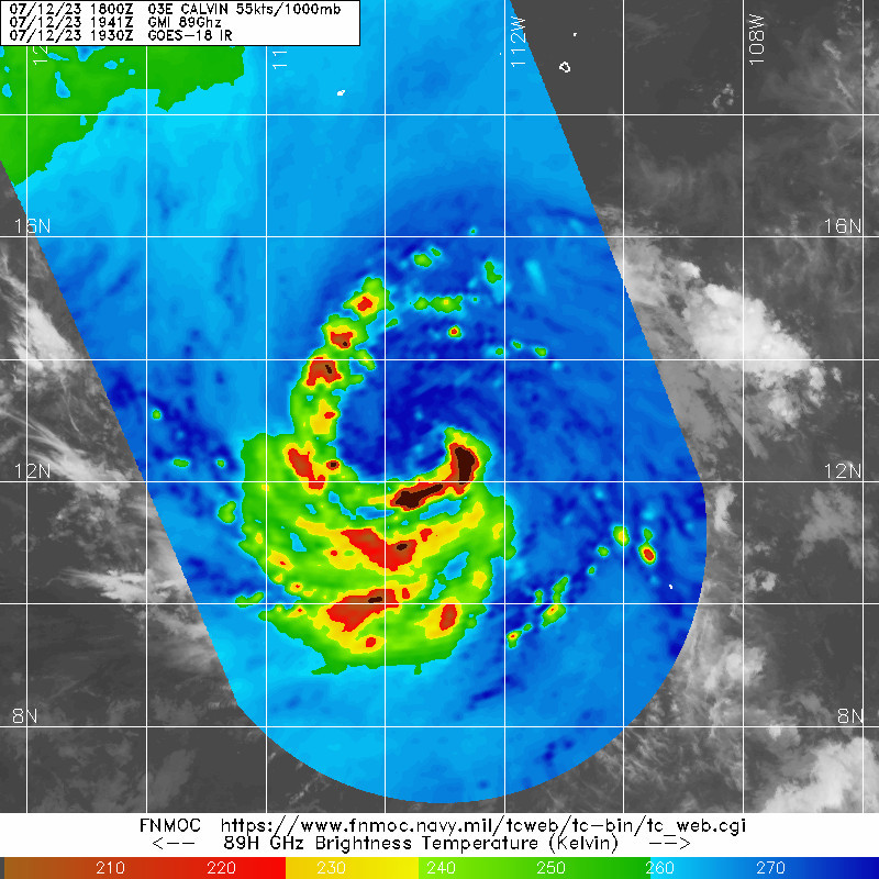
A. 03E (CALVIN)
B. 12/1800Z
C. 12.6N
D. 113.0W
E. THREE/GOES-E
F. T3.0/3.0
G. IR/EIR/VIS
H. REMARKS...7/10 BANDING ON A LOG10 SPIRAL YIELDS A DT OF 3.0. MET
IS 2.5 DUE TO A DEVELOPING TREND OVER THE LAST 24 HOURS. PT AGREES WITH
DT. THE FT IS BASED ON THE DT.
I. ADDL POSITIONS
NIL
...NGUYEN
B. 12/1800Z
C. 12.6N
D. 113.0W
E. THREE/GOES-E
F. T3.0/3.0
G. IR/EIR/VIS
H. REMARKS...7/10 BANDING ON A LOG10 SPIRAL YIELDS A DT OF 3.0. MET
IS 2.5 DUE TO A DEVELOPING TREND OVER THE LAST 24 HOURS. PT AGREES WITH
DT. THE FT IS BASED ON THE DT.
I. ADDL POSITIONS
NIL
...NGUYEN
0 likes
Visit the Caribbean-Central America Weather Thread where you can find at first post web cams,radars
and observations from Caribbean basin members Click Here
and observations from Caribbean basin members Click Here
-
cycloneye
- Admin
- Posts: 149703
- Age: 69
- Joined: Thu Oct 10, 2002 10:54 am
- Location: San Juan, Puerto Rico
Re: EPAC: CALVIN - Tropical Storm - Discussion
Sciencerocks wrote:A little bit of a banding eyewall starting to wrap! Probably 55 knots!
https://imagizer.imageshack.com/img924/7530/yzpMxh.gif
Yes. is possible that the trends are for Calvin to be a hurricane tonight.
EP, 03, 2023071218, , BEST, 0, 127N, 1131W, 55, 1000, TS
0 likes
Visit the Caribbean-Central America Weather Thread where you can find at first post web cams,radars
and observations from Caribbean basin members Click Here
and observations from Caribbean basin members Click Here
-
Yellow Evan
- Professional-Met
- Posts: 16257
- Age: 27
- Joined: Fri Jul 15, 2011 12:48 pm
- Location: Henderson, Nevada/Honolulu, HI
- Contact:
Re: EPAC: CALVIN - Tropical Storm - Discussion
Looks more than .7 banding to me but whatever.
Warm spot will likely get obscured fairly soon by recent CB. How much this rotates determines whether it’ll become a hurricane tonight. We are in position to make a run at major on Friday unless something goes horribly wrong but there will be hiccups in the meantime.

Warm spot will likely get obscured fairly soon by recent CB. How much this rotates determines whether it’ll become a hurricane tonight. We are in position to make a run at major on Friday unless something goes horribly wrong but there will be hiccups in the meantime.
2 likes
-
Yellow Evan
- Professional-Met
- Posts: 16257
- Age: 27
- Joined: Fri Jul 15, 2011 12:48 pm
- Location: Henderson, Nevada/Honolulu, HI
- Contact:
Re: EPAC: CALVIN - Tropical Storm - Discussion
* GFS version *
* EAST PACIFIC 2023 SHIPS INTENSITY FORECAST *
* IR SAT DATA AVAILABLE, OHC AVAILABLE *
* CALVIN EP032023 07/12/23 18 UTC *
TIME (HR) 0 6 12 18 24 36 48 60 72 84 96 108 120 132 144 156 168
V (KT) NO LAND 55 62 67 72 78 84 87 88 80 73 66 60 56 51 49 47 49
V (KT) LAND 55 62 67 72 78 84 87 88 80 73 66 60 56 51 49 47 47
V (KT) LGEM 55 63 69 74 78 83 83 79 74 66 58 53 49 45 41 37 35
Storm Type TROP TROP TROP TROP TROP TROP TROP TROP TROP TROP TROP TROP TROP TROP TROP TROP TROP
SHEAR (KT) 10 10 10 9 9 8 5 7 6 5 4 6 7 13 14 18 19
SHEAR ADJ (KT) 1 0 3 1 0 -1 0 -4 0 2 7 5 4 1 1 3 0
SHEAR DIR 32 347 347 347 338 312 282 142 157 170 182 179 194 202 206 189 184
SST (C) 28.3 28.2 28.4 28.6 28.7 28.3 26.2 25.7 25.5 24.4 23.9 24.2 24.7 25.0 25.1 25.4 26.5
POT. INT. (KT) 149 148 150 152 153 149 127 122 120 109 104 107 112 115 116 119 131
200 MB T (C) -52.0 -51.6 -51.9 -52.1 -51.9 -52.2 -52.1 -51.7 -52.1 -52.0 -52.4 -52.4 -52.7 -52.9 -53.2 -53.3 -53.6
200 MB VXT (C) 0.1 0.1 0.1 0.2 0.2 0.5 0.3 0.1 0.1 0.3 0.7 0.6 0.6 0.2 -0.1 -0.3 0.1
TH_E DEV (C) 5 5 5 5 4 3 3 2 2 1 1 1 2 2 2 4 4
700-500 MB RH 78 78 79 81 80 81 78 72 65 60 54 50 49 48 47 47 47
MODEL VTX (KT) 18 19 18 19 22 23 25 25 23 21 19 17 14 12 9 7 7
850 MB ENV VOR 11 9 13 18 27 30 35 38 35 43 41 47 49 44 28 22 11
200 MB DIV 21 28 38 45 38 56 -1 3 -18 -16 1 -2 -13 -8 -1 14 24
700-850 TADV 3 2 -1 -4 -6 -6 3 -1 -1 4 -1 6 3 8 19 14 12
LAND (KM) 1142 1231 1295 1358 1434 1608 1769 1939 2160 2266 1912 1575 1234 881 526 163 75
LAT (DEG N) 12.7 12.7 12.7 12.9 13.0 13.4 14.0 14.7 15.0 15.6 16.4 17.0 17.4 xx.x xx.x xx.x xx.x
LONG(DEG W) 113.1 114.5 115.9 117.3 118.7 121.5 124.5 127.5 130.7 133.8 137.0 140.1 143.3 xxx.x xxx.x xxx.x xxx.x
STM SPEED (KT) 14 14 14 14 14 14 15 15 16 15 15 15 16 16 16 16 16
HEAT CONTENT 24 15 11 11 12 13 0 0 0 0 0 0 0 0 0 0 2
FORECAST TRACK FROM OFCI INITIAL HEADING/SPEED (DEG/KT):275/ 15 CX,CY: -14/ 1
T-12 MAX WIND: 35 PRESSURE OF STEERING LEVEL (MB): 499 (MEAN=588)
GOES IR BRIGHTNESS TEMP. STD DEV. 50-200 KM RAD: 12.8 (MEAN=14.5)
% GOES IR PIXELS WITH T < -20 C 50-200 KM RAD: 92.0 (MEAN=65.0)
PRELIM RI PROB (DV .GE. 35 KT IN 36 HR): 38.5
INDIVIDUAL CONTRIBUTIONS TO INTENSITY CHANGE
6 12 18 24 36 48 60 72 84 96 108 120 132 144 156 168
--------------------------------------------------------------------------------------------
SAMPLE MEAN CHANGE 0. 1. 1. 1. 1. 2. 2. 1. 1. -0. -1. -1. -2. -3. -3. -4.
SST POTENTIAL 1. 3. 5. 7. 10. 14. 17. 18. 18. 18. 17. 14. 12. 10. 9. 8.
VERTICAL SHEAR MAG -0. -0. -0. -1. -0. 0. 2. 3. 4. 6. 7. 8. 8. 8. 8. 7.
VERTICAL SHEAR ADJ 0. -0. -0. -0. -0. -0. 0. 0. 0. -0. -0. -0. -0. -0. -0. -0.
VERTICAL SHEAR DIR 0. 0. 0. 0. -0. -2. -1. -1. -1. -2. -2. -2. -2. -1. -1. -0.
PERSISTENCE 4. 6. 7. 7. 6. 5. 4. 3. 2. 2. 2. 2. 2. 2. 2. 2.
200/250 MB TEMP. -0. -0. -0. -1. -1. -1. -1. -1. -2. -1. -1. -0. 0. 0. -0. -1.
THETA_E EXCESS -0. -0. -0. -1. -2. -3. -4. -5. -6. -7. -7. -7. -7. -7. -6. -6.
700-500 MB RH 0. 0. 1. 1. 2. 2. 2. 2. 2. 1. 1. 1. 0. 0. 0. 1.
MODEL VTX TENDENCY 0. 0. 1. 3. 3. 7. 9. 7. 4. 1. -2. -5. -7. -9. -10. -10.
850 MB ENV VORTICITY -0. -0. -0. -0. -0. -0. 0. 0. -0. -0. -0. -0. -0. -0. -0. -0.
200 MB DIVERGENCE -0. -0. -0. -0. 0. -0. -0. -1. -1. -2. -1. -1. -0. 0. 0. 0.
850-700 T ADVEC -0. -0. -0. 0. 0. 0. 0. 0. 0. -0. -0. 0. 0. 0. 1. 2.
ZONAL STORM MOTION 0. -0. -0. -0. 0. 0. 0. -0. -0. -0. -1. -1. -1. -1. -2. -3.
STEERING LEVEL PRES -0. -0. -0. -1. -1. -1. -1. -1. -2. -2. -2. -2. -2. -2. -1. -1.
DAYS FROM CLIM. PEAK -0. -0. -0. -0. -0. -0. -0. -1. -1. -1. -2. -2. -2. -3. -3. -4.
GOES PREDICTORS 1. 1. 1. 1. 1. 1. 2. 2. 2. 2. 2. 2. 2. 2. 2. 2.
OCEAN HEAT CONTENT -0. 0. 0. 0. 0. -0. -0. -0. 0. 0. 0. 0. 1. 2. 3. 4.
RI POTENTIAL 1. 2. 4. 6. 10. 9. 5. 1. -1. -3. -4. -5. -5. -5. -5. -4.
--------------------------------------------------------------------------------------------
TOTAL CHANGE 7. 12. 17. 23. 29. 32. 33. 26. 18. 11. 5. 1. -4. -6. -8. -6.
CURRENT MAX WIND (KT): 55. LAT, LON: 12.7 113.1
** 2023 E. PACIFIC RI INDEX EP032023 CALVIN 07/12/23 18 UTC **
(SHIPS-RII PREDICTOR TABLE for 30 KT OR MORE MAXIMUM WIND INCREASE IN NEXT 24-h)
Predictor Value RI Predictor Range Scaled Value(0-1) % Contribution
POT = MPI-VMAX (KT) : 95.3 36.9 to 148.5 0.52 7.8
12 HR PERSISTENCE (KT) : 20.0 -22.0 to 44.0 0.64 8.2
MULTI-LAYER SHEAR (KT) : 20.7 30.9 to 7.7 0.44 4.5
BL DRY-AIR FLUX (W/M2) : 116.0 816.2 to -81.4 0.78 -9.0
D200 (10**7s-1) : 34.0 -33.0 to 159.5 0.35 3.1
MAXIMUM WIND (KT) : 55.0 22.5 to 132.0 0.93 8.1
STD DEV OF IR BR TEMP : 12.8 37.8 to 2.1 0.70 5.0
HEAT CONTENT (KJ/CM2) : 14.6 2.7 to 103.4 0.12 0.5
%area of TPW <45 mm upshear : 0.0 49.8 to 0.0 1.00 2.7
2nd PC OF IR BR TEMP : -0.8 2.2 to -2.3 0.68 0.1
SHIPS Prob RI for 20kt/ 12hr RI threshold= 22% is 3.4 times climatological mean ( 6.3%)
SHIPS Prob RI for 25kt/ 24hr RI threshold= 40% is 3.2 times climatological mean (12.5%)
SHIPS Prob RI for 30kt/ 24hr RI threshold= 31% is 3.6 times climatological mean ( 8.6%)
SHIPS Prob RI for 35kt/ 24hr RI threshold= 23% is 3.6 times climatological mean ( 6.2%)
SHIPS Prob RI for 40kt/ 24hr RI threshold= 13% is 3.1 times climatological mean ( 4.2%)
SHIPS Prob RI for 45kt/ 36hr RI threshold= 25% is 3.8 times climatological mean ( 6.7%)
SHIPS Prob RI for 55kt/ 48hr RI threshold= 17% is 2.8 times climatological mean ( 5.9%)
SHIPS Prob RI for 65kt/ 72hr RI threshold= 8% is 1.6 times climatological mean ( 4.7%)
Matrix of RI probabilities
------------------------------------------------------------------------------
RI (kt / h) | 20/12 | 25/24 | 30/24 | 35/24 | 40/24 | 45/36 | 55/48 |65/72
------------------------------------------------------------------------------
SHIPS-RII: 21.7% 40.3% 31.1% 22.6% 13.1% 25.5% 16.7% 7.6%
Logistic: 17.1% 40.8% 17.8% 13.2% 3.7% 13.1% 10.0% 11.6%
Bayesian: 12.8% 34.7% 11.8% 5.8% 2.7% 9.1% 1.4% 0.0%
Consensus: 17.2% 38.6% 20.2% 13.8% 6.5% 15.9% 9.4% 6.4%
DTOPS: 31.0% 50.0% 44.0% 31.0% 18.0% 45.0% 13.0% 1.0%
## ANNULAR HURRICANE INDEX (AHI) EP032023 CALVIN 07/12/23 18 UTC ##
## STORM NOT ANNULAR, SCREENING STEP FAILED, NPASS=5 NFAIL=2 ##
## AHI= 0 (AHI OF 100 IS BEST FIT TO ANN. STRUC., 1 IS MARGINAL, 0 IS NOT ANNULAR) ##
0 likes
-
cycloneye
- Admin
- Posts: 149703
- Age: 69
- Joined: Thu Oct 10, 2002 10:54 am
- Location: San Juan, Puerto Rico
Re: EPAC: CALVIN - Tropical Storm - Discussion
Tropical Storm Calvin Discussion Number 5
NWS National Hurricane Center Miami FL EP032023
1100 AM HST Wed Jul 12 2023
Tropical Storm Calvin continues to strengthen this morning, with an
improved structure on hi-res GOES visible satellite imagery. A
curved band is beginning to wrap around the center, however, the
band has not yet completely filled in around the northern side.
Subjective satellite Dvorak estimates from TAFB and SAB were T3.5/55
kt and T3.0/45 kt, respectively, while the latest objective
estimates from SATCON and ADT are higher than 55 kt. Given the
improved structure on satellite, the initial intensity is raised to
55 kt for this advisory based on a blend of the various intensity
estimates.
Calvin is in a conducive environment for strengthening, with
light-to-moderate vertical wind shear, and warm sea surface
temperatures. Steady strengthening is forecast the next several
days, with Calvin potentially becoming a hurricane later tonight.
Rapid intensification (RI) guidance has increased on this
cycle and now shows a roughly 3-in-10 chance for RI to occur during
the next 24 hours. Therefore, the NHC intensity forecast is near
the upper end of the guidance, and the peak intensity has been
slightly raised from the previous forecast. By the weekend, Calvin
is expected to cross over cooler SSTs which will likely cause
gradual weakening through the remainder of the forecast period.
Calvin is moving westward or 275/15 kt. A strong ridge located to
the north of Calvin will continue to steer the cyclone westward to
west-northwestward throughout the forecast period. Model guidance
is in fairly good agreement with the track--the main difference is
the forward speed of Calvin with some models moving the storm a
little faster (particularly HCCA). The updated NHC track forecast
lies near the center of the guidance envelope, but is a little on
the faster side of forecast ensembles.
FORECAST POSITIONS AND MAX WINDS
INIT 12/2100Z 12.8N 113.8W 55 KT 65 MPH
12H 13/0600Z 12.9N 115.9W 65 KT 75 MPH
24H 13/1800Z 13.1N 118.6W 75 KT 85 MPH
36H 14/0600Z 13.6N 121.3W 85 KT 100 MPH
48H 14/1800Z 14.3N 124.3W 85 KT 100 MPH
60H 15/0600Z 14.9N 127.3W 80 KT 90 MPH
72H 15/1800Z 15.6N 130.4W 75 KT 85 MPH
96H 16/1800Z 16.8N 136.7W 60 KT 70 MPH
120H 17/1800Z 17.8N 143.7W 50 KT 60 MPH
$$
Forecaster Kelly/Berg
0 likes
Visit the Caribbean-Central America Weather Thread where you can find at first post web cams,radars
and observations from Caribbean basin members Click Here
and observations from Caribbean basin members Click Here
-
Kingarabian
- S2K Supporter
- Posts: 16378
- Joined: Sat Aug 08, 2009 3:06 am
- Location: Honolulu, Hawaii
Re: EPAC: CALVIN - Tropical Storm - Discussion
Won't get past minimal hurricane status if it doesn't seal off the dry air that's currently entrained. Core is also walking a fine line of being closed or partially exposed.
1 likes
RIP Kobe Bryant
-
Yellow Evan
- Professional-Met
- Posts: 16257
- Age: 27
- Joined: Fri Jul 15, 2011 12:48 pm
- Location: Henderson, Nevada/Honolulu, HI
- Contact:
Re: EPAC: CALVIN - Tropical Storm - Discussion
1 likes
-
Sciencerocks
- Category 5
- Posts: 10193
- Age: 40
- Joined: Thu Jul 06, 2017 1:51 am

-
Sciencerocks
- Category 5
- Posts: 10193
- Age: 40
- Joined: Thu Jul 06, 2017 1:51 am

-
cycloneye
- Admin
- Posts: 149703
- Age: 69
- Joined: Thu Oct 10, 2002 10:54 am
- Location: San Juan, Puerto Rico
Re: EPAC: CALVIN - Tropical Storm - Discussion
Wow, 4.0.
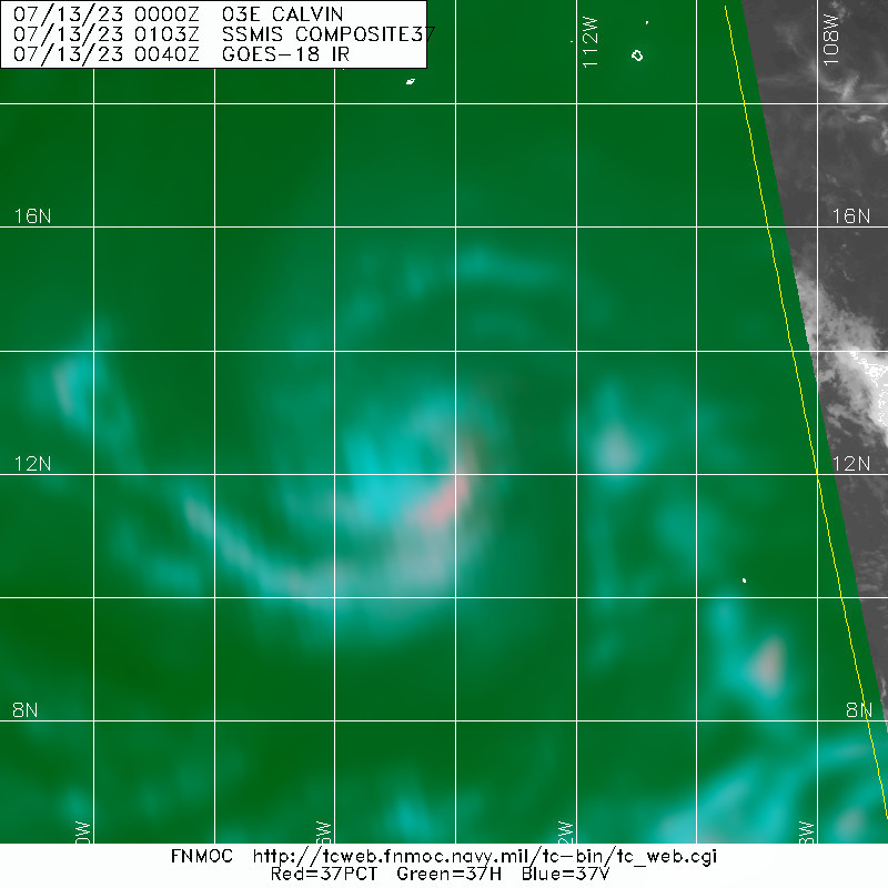
A. 03E (CALVIN)
B. 13/0000Z
C. 12.5N
D. 114.2W
E. THREE/GOES-W
F. T4.0/4.0
G. IR/EIR/VIS/AMSR2/SSMIS
H. REMARKS...9/10 BANDING YIELDS A DT OF 3.5. THE MET IS 3.5 BASED ON
A RAPID DEVELOPMENT TREND OVER THE PAST 24 HOURS. THE PT IS 4.0 AFTER A
PATTERN ADJUSTMENT. THE FT IS BASED ON THE PT DUE TO THE CLOUD TOPS IN
THE OUTER BAND STARTING TO WARM.
I. ADDL POSITIONS
12/2101Z 12.7N 113.7W AMSR2
12/2310Z 12.5N 114.2W SSMIS
...COVERDALE
0 likes
Visit the Caribbean-Central America Weather Thread where you can find at first post web cams,radars
and observations from Caribbean basin members Click Here
and observations from Caribbean basin members Click Here
-
cycloneye
- Admin
- Posts: 149703
- Age: 69
- Joined: Thu Oct 10, 2002 10:54 am
- Location: San Juan, Puerto Rico
Re: EPAC: CALVIN - Tropical Storm - Discussion
BT not yet as hurricane.
EP, 03, 2023071300, , BEST, 0, 125N, 1142W, 60, 995, TS
0 likes
Visit the Caribbean-Central America Weather Thread where you can find at first post web cams,radars
and observations from Caribbean basin members Click Here
and observations from Caribbean basin members Click Here
-
Yellow Evan
- Professional-Met
- Posts: 16257
- Age: 27
- Joined: Fri Jul 15, 2011 12:48 pm
- Location: Henderson, Nevada/Honolulu, HI
- Contact:
Re: EPAC: CALVIN - Tropical Storm - Discussion
EP, 03, 202307130000, 10, DVTS, CI, , 1250N, 11420W, , 2, 55, 2, 994, 2, DVRK, , , , , , , , , , , , , , E, TAFB, ERA, VI, 3, 3535 /////, , , GOES18, CSC, T,
0 likes
-
Kingarabian
- S2K Supporter
- Posts: 16378
- Joined: Sat Aug 08, 2009 3:06 am
- Location: Honolulu, Hawaii
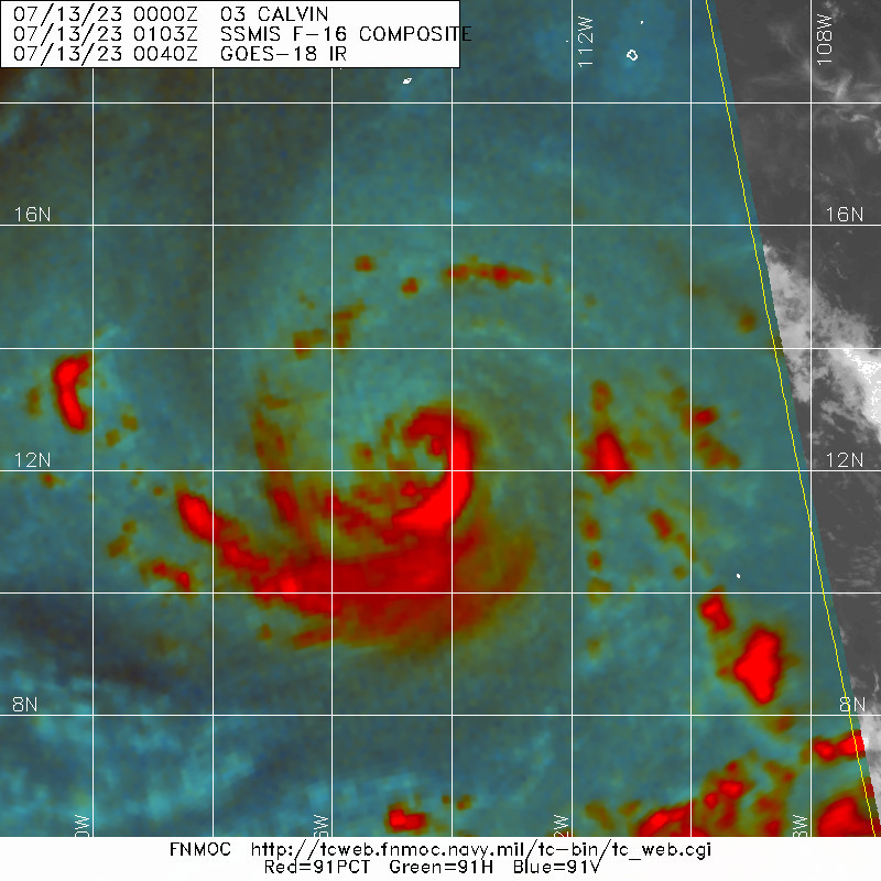
Re: EPAC: CALVIN - Tropical Storm - Discussion
Would call this a hurricane. Cyan ring well defined and at the mid levels the core is doing better.
2 likes
RIP Kobe Bryant
Who is online
Users browsing this forum: No registered users and 59 guests