EPAC: HILARY - Post-Tropical - Discussion

Moderator: S2k Moderators

Message
Author
User avatar
cycloneye
Admin
Admin
Posts: 139756
Age: 67
Joined: Thu Oct 10, 2002 10:54 am
Location: San Juan, Puerto Rico

Re: EPAC: HILARY - Tropical Storm - Discussion

#81 Postby cycloneye » Wed Aug 16, 2023 8:36 pm

Yellow Evan wrote:CB just occurred in the upshear right and convection in general is curling into the upshear semicircle. This should be a hurricane in the morning. I'd wait to see how large its core is before assessing RI chances past minimal hurricane status but really ever since it was invested 48 hours ago, it has been organizing at a very quick pace.


We will have recon on Friday and that will be very interesting to see how large is the windfield apart from the intensity.
1 likes   
Visit the Caribbean-Central America Weather Thread where you can find at first post web cams,radars
and observations from Caribbean basin members Click Here

User avatar
gatorcane
S2K Supporter
S2K Supporter
Posts: 23499
Age: 46
Joined: Sun Mar 13, 2005 3:54 pm
Location: Boca Raton, FL

Re: EPAC: HILARY - Tropical Storm - Discussion

#82 Postby gatorcane » Wed Aug 16, 2023 8:56 pm

A beast in the making:

Image
2 likes   

Socalhurcnegirl227
Category 1
Category 1
Posts: 267
Age: 35
Joined: Mon Jun 06, 2016 6:39 pm
Location: Santa Barbara, CA

Re: EPAC: HILARY - Tropical Storm - Discussion

#83 Postby Socalhurcnegirl227 » Wed Aug 16, 2023 9:20 pm


if this becomes stronger than anticipated are there any SSTs closer here to socal to potentially have stronger impacts and not weaken as fast?
0 likes   
"I'm a wandress, i'm a one night stand,
dont belong to no city, dont belong to no man
i'm the violence in the pouring rain,
I'm a hurricane"

IcyTundra
Category 3
Category 3
Posts: 894
Joined: Mon Jun 07, 2021 9:32 pm
Location: Dickinson, Texas

Re: EPAC: HILARY - Tropical Storm - Discussion

#84 Postby IcyTundra » Wed Aug 16, 2023 9:31 pm

Socalhurcnegirl227 wrote:

if this becomes stronger than anticipated are there any SSTs closer here to socal to potentially have stronger impacts and not weaken as fast?


SST’s off of the Southern California coast are around 67-68 degrees Fahrenheit so the storm should be decaying on approach to California. If it gets stronger than expected before it runs into the cold SST’s perhaps there is a higher chance of Southern California experiencing TS force winds, but I would say the main concern for y’all would be flooding rain fall.
1 likes   

Socalhurcnegirl227
Category 1
Category 1
Posts: 267
Age: 35
Joined: Mon Jun 06, 2016 6:39 pm
Location: Santa Barbara, CA

Re: EPAC: HILARY - Tropical Storm - Discussion

#85 Postby Socalhurcnegirl227 » Wed Aug 16, 2023 9:40 pm

IcyTundra wrote:
Socalhurcnegirl227 wrote:

if this becomes stronger than anticipated are there any SSTs closer here to socal to potentially have stronger impacts and not weaken as fast?


SST’s off of the Southern California coast are around 67-68 degrees Fahrenheit so the storm should be decaying on approach to California. If it gets stronger than expected before it runs into the cold SST’s perhaps there is a higher chance of Southern California experiencing TS force winds, but I would say the main concern for y’all would be flooding rain fall.


Whatever happens, im sure as hell not gonna complain. This winter was a godsend and actually getting rain like this at a time thats historically hot and excessively dry is a miracle. Im enjoying these odd years of getting tropical impacts. Its quite a fun treat
0 likes   
"I'm a wandress, i'm a one night stand,
dont belong to no city, dont belong to no man
i'm the violence in the pouring rain,
I'm a hurricane"

User avatar
cycloneye
Admin
Admin
Posts: 139756
Age: 67
Joined: Thu Oct 10, 2002 10:54 am
Location: San Juan, Puerto Rico

Re: EPAC: HILARY - Tropical Storm - Discussion

#86 Postby cycloneye » Wed Aug 16, 2023 9:48 pm

Tropical Storm Hilary Discussion Number 3
NWS National Hurricane Center Miami FL EP092023
1000 PM CDT Wed Aug 16 2023

This evening, Hilary appears to be getting its act together, with
its structure quickly improving. Satellite imagery shows a
well-defined curved band wrapping around the storm's southern
semicircle, with deep convection blossoming near the estimated
center. Earlier microwave imagery also suggested that a tighter
center might have reformed a bit further to the south, more
embedded in the deep convection. The latest subjective Dvorak
estimates form TAFB and SAB were 35 kt at 0000 UTC. However, the
objective estimates have risen more quickly, with the most recent
ADT estimate at 49 kt, and SATCON at 48 kt. The initial intensity
this advisory is set at 45 kt, closer to these higher end
estimates.

While Hilary may have earlier reformed a bit closer to the
convection, its estimated motion still appears to be
west-northwestward, just a tad slower than earlier at 290/10 kt.
Initially, Hilary is being steered west-northwestward by a prominent
mid-level ridge draped between northwest Mexico and the four corners
region of the US. However, this ridging is expected to shift
eastward, allowing a large weakness to appear to the south of a
deep-layer cutoff low that remains parked just offshore of central
California. The net impact of this synoptic pattern evolution is
that Hilary will begin to turn to the northwest and north between
48-72 hours with some gradual acceleration as the tropical cyclone
is steered between the cutoff low to the west, and the mid-level
ridge to the east. While the track guidance this cycle shifted a bit
to the west in the short term, this is more a reflection of an
initial position adjustment, and the NHC track forecast was not
modified much from the prior cycle. This track forecast opts to
remain on the east side of the track guidance envelope, between the
consensus aids and the GFS forecast track. On this forecast track,
Hilary could pass near or over the Baja California peninsula
sometime over the weekend.

Assuming the storm is in the initial stages of developing an inner
core, Hilary appears poised to intensify, likely rapidly, over the
next couple of days. SHIPS-RII predictors are basically as high as
they can go, thanks in part to low shear, very warm sea-surface
temperatures, and high mid-level environmental moisture. In fact,
the latest SHIPS-RII cycle shows a 100 percent chance of a 45 kt
increase in intensity over the next 36 hours. That is verbatim what
the latest NHC intensity forecast shows, and Hilary is forecast to
become a major hurricane in a couple of days. After that time, the
large wind field of Hilary may begin to upwell some cooler waters,
with sea-surface temperatures dropping under 26 C between 72-96 h.
Possible land interaction may also begin to disrupt the core
structure of the storm during that time as it nears the Baja
California peninsula. A combination of these factors should
ultimately cause Hilary to become a post-tropical cyclone by the end
of the forecast period. The NHC intensity forecast is in best
agreement with the HFIP Corrected Consensus Approach (HCCA).

As stated previously, it is important to remind users to not focus
on the exact forecast track and intensity of Hilary, especially in
the latter parts of the forecast period. Due to the forecast
parallel angle of approach to the Baja California peninsula, small
changes in the cross track position may result in large changes to
when and where the system ultimately approaches the coast.
Regardless, the large size of the cyclone means wind and rainfall
impacts are likely to extend far from the center of Hilary.

KEY MESSAGES:

1. Hilary has the potential to bring impacts to the Baja California
Peninsula and portions of the southwestern United States this
weekend. Although it is too soon to determine the location and
magnitude of rainfall and wind impacts, interests in these areas
should monitor the progress of Hilary and updates to the forecast.
Watches may be required for parts of the Baja California Peninsula
as soon as tomorrow morning.

2. Large swells from Hilary will spread northward along the coast
of southwestern Mexico and the Baja California Peninsula during the
next several days.


FORECAST POSITIONS AND MAX WINDS

INIT 17/0300Z 13.4N 105.1W 45 KT 50 MPH
12H 17/1200Z 14.3N 106.9W 60 KT 70 MPH
24H 18/0000Z 15.5N 109.1W 75 KT 85 MPH
36H 18/1200Z 16.8N 111.0W 90 KT 105 MPH
48H 19/0000Z 18.5N 112.5W 100 KT 115 MPH
60H 19/1200Z 20.5N 113.4W 105 KT 120 MPH
72H 20/0000Z 22.6N 114.0W 95 KT 110 MPH
96H 21/0000Z 28.3N 115.4W 60 KT 70 MPH
120H 22/0000Z 34.3N 117.7W 35 KT 40 MPH...POST-TROP/INLAND

$$
Forecaster Papin
0 likes   
Visit the Caribbean-Central America Weather Thread where you can find at first post web cams,radars
and observations from Caribbean basin members Click Here

Sciencerocks
Category 5
Category 5
Posts: 7353
Age: 38
Joined: Thu Jul 06, 2017 1:51 am

Re: EPAC: HILARY - Tropical Storm - Discussion

#87 Postby Sciencerocks » Wed Aug 16, 2023 9:58 pm

Image
0 likes   

User avatar
cycloneye
Admin
Admin
Posts: 139756
Age: 67
Joined: Thu Oct 10, 2002 10:54 am
Location: San Juan, Puerto Rico

Re: EPAC: HILARY - Tropical Storm - Discussion

#88 Postby cycloneye » Wed Aug 16, 2023 10:31 pm

0 likes   
Visit the Caribbean-Central America Weather Thread where you can find at first post web cams,radars
and observations from Caribbean basin members Click Here

User avatar
Landy
Category 1
Category 1
Posts: 313
Joined: Wed Aug 11, 2021 7:43 pm
Location: Port Orange, FL

Re: EPAC: HILARY - Tropical Storm - Discussion

#89 Postby Landy » Thu Aug 17, 2023 4:08 am

Hilary is wasting no time. Image
1 likes   

User avatar
Yellow Evan
Professional-Met
Professional-Met
Posts: 15960
Age: 25
Joined: Fri Jul 15, 2011 12:48 pm
Location: Henderson, Nevada/Honolulu, HI
Contact:

Re: EPAC: HILARY - Tropical Storm - Discussion

#90 Postby Yellow Evan » Thu Aug 17, 2023 4:28 am

Very common for larger eye storms to look good at clearing and then swallow dry air but
1. the core isn’t that big and
2. low shear should allow the CDO to smooth out and effectively shield off any dry air intrusions for the time being

Satellite presentation strongly indicative of a TC that deepens at a rate of ~60 knots/day.
1 likes   

hurricanes1234
Category 5
Category 5
Posts: 2904
Joined: Sat Jul 28, 2012 6:19 pm
Location: Trinidad and Tobago

Re: EPAC: HILARY - Tropical Storm - Discussion

#91 Postby hurricanes1234 » Thu Aug 17, 2023 4:28 am

Up to 60 knots

478 WTPZ44 KNHC 170857 TCDEP4
Tropical Storm Hilary Discussion Number 4
NWS National Hurricane Center Miami FL
EP092023 300 AM MDT Thu Aug 17 2023

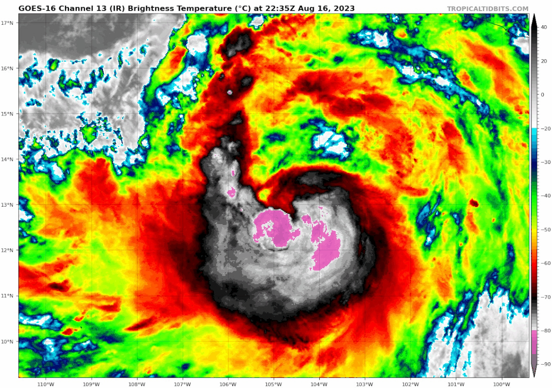
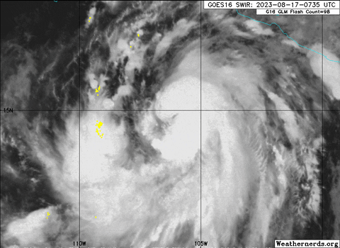
Hilary is a large tropical storm. An elongated band of deep convection curves around the southern and eastern side of the circulation, and a Central Dense Overcast has begun to develop due to new convection near Hilary's center, with possibly the formative stages of an eye. Subjective Dvorak estimates from TAFB and SAB have jumped to a consensus T3.5/55 kt, and given the improved satellite presentation since 06 UTC, the initial intensity is set at 60 kt.

Hilary is moving toward the west-northwest (300/11 kt), to the south of a mid-tropospheric high stretching from the U.S. Rockies southward into northern Mexico. The ridge is expected to shift eastward to the Central Plains during the next 48 hours, while a mid- to upper-level low moves eastward to the California coast. This steering pattern evolution should cause Hilary to recurve toward the northwest and then north during the next 3 days. Model guidance is in generally good agreement on Hilary's future path, with a fairly tightly packed guidance envelope for much of the forecast period. Therefore, the new NHC track forecast is very close to a blend of the previous forecast with the HFIP Corrected Consensus aid (HCCA) and the TVCE consensus. Despite the high confidence in the track, Hilary's oblique angle of approach to the west coast of the Baja California peninsula does make it nearly impossible to know at this point if the center will remain just offshore or move over the peninsula before reaching the southwestern United States.

Negligible shear, very warm waters of 30 degrees Celsius, and plentiful atmospheric moisture mean the environment is ripe for Hilary to rapidly intensify during the next couple of days. In fact, many of the SHIPS Rapid Intensification (RI) indices are showing a 100 percent chance of RI during the next 48 hours. The NHC intensity forecast follows this thinking and shows Hilary becoming a hurricane very soon and then a major hurricane by tonight or early Friday, more or less a blend of the HCCA aid and the SHIPS solutions. Hilary should reach waters colder than 26 degrees Celsius soon after 72 hours, and fast weakening is indicated after that time, especially if the storm crosses over the Baja California peninsula. The surface circulation is likely to be dissipated by day 5, but a day 5 forecast point (as a remnant low) is still provided to maintain a forecast track north of the Baja California peninsula.

KEY MESSAGES:

1. Hilary has the potential to bring significant impacts to the Baja California Peninsula and portions of the southwestern United States this weekend and early next week, including after it becomes post-tropical. Although it is too soon to determine the location and magnitude of wind impacts, interests in these areas should monitor the progress of Hilary and updates to the forecast. A Tropical Storm Watch is now in effect for southern portions of Baja California Sur, and additional watches or warnings will likely be required later today.

2. Heavy rainfall associated with Hilary may produce areas of flash flooding and result in landslides over portions of the Baja California peninsula from late Friday into late Sunday. Rainfall impacts from Hilary within the Southwestern United States are expected to peak on Sunday and Monday.

3. Large swells from Hilary will spread northward along the coast of southwestern Mexico and the Baja California Peninsula during the next several days.

FORECAST POSITIONS AND MAX WINDS
INIT 17/0900Z 14.6N 106.3W 60 KT 70 MPH
12H 17/1800Z 15.5N 108.0W 75 KT 85 MPH
24H 18/0600Z 16.7N 110.1W 95 KT 110 MPH
36H 18/1800Z 18.1N 111.7W 110 KT 125 MPH
48H 19/0600Z 19.9N 113.0W 115 KT 130 MPH
60H 19/1800Z 22.0N 113.8W 110 KT 125 MPH
72H 20/0600Z 24.6N 114.3W 95 KT 110 MPH
96H 21/0600Z 31.6N 116.0W 50 KT 60 MPH...INLAND
120H 22/0600Z 39.1N 118.6W 25 KT 30 MPH...POST-TROP/INLAND

$$
Forecaster Berg
0 likes   
PLEASE NOTE: With the exception of information from weather agencies that I may copy and paste here, my posts will NEVER be official, since I am NOT a meteorologist. They are solely my amateur opinion, and may or may not be accurate. Therefore, please DO NOT use them as official details, particularly when making important decisions. Thank you.

User avatar
GCANE
S2K Supporter
S2K Supporter
Posts: 10787
Joined: Mon Oct 22, 2007 8:03 am

Re: EPAC: HILARY - Tropical Storm - Discussion

#92 Postby GCANE » Thu Aug 17, 2023 5:16 am

Looks like rapid eyewall development
0 likes   

User avatar
GCANE
S2K Supporter
S2K Supporter
Posts: 10787
Joined: Mon Oct 22, 2007 8:03 am

Re: EPAC: HILARY - Tropical Storm - Discussion

#93 Postby GCANE » Thu Aug 17, 2023 5:18 am

Vorts are stacked all the way thru 200mb
0 likes   

User avatar
REDHurricane
Tropical Storm
Tropical Storm
Posts: 215
Age: 26
Joined: Sun Jul 03, 2022 2:36 pm
Location: Northeast Pacific Ocean

Re: EPAC: HILARY - Tropical Storm - Discussion

#94 Postby REDHurricane » Thu Aug 17, 2023 5:58 am

And off she goes.

Image
0 likes   

User avatar
Zonacane
Tropical Storm
Tropical Storm
Posts: 221
Joined: Tue Aug 03, 2021 2:23 pm

Re: EPAC: HILARY - Tropical Storm - Discussion

#95 Postby Zonacane » Thu Aug 17, 2023 6:57 am

How much rain will Tucson get, And will we see any TS force winds from Hillary?
0 likes   

User avatar
GCANE
S2K Supporter
S2K Supporter
Posts: 10787
Joined: Mon Oct 22, 2007 8:03 am

Re: EPAC: HILARY - Tropical Storm - Discussion

#96 Postby GCANE » Thu Aug 17, 2023 7:20 am

Advancing dry-line convection to the NW of the CoC looks to be taking out some of the dry air.
0 likes   

User avatar
GCANE
S2K Supporter
S2K Supporter
Posts: 10787
Joined: Mon Oct 22, 2007 8:03 am

Re: EPAC: HILARY - Tropical Storm - Discussion

#97 Postby GCANE » Thu Aug 17, 2023 7:22 am

Rotating eyewall hot-tower is building CDO and layering cirrus
0 likes   

User avatar
GCANE
S2K Supporter
S2K Supporter
Posts: 10787
Joined: Mon Oct 22, 2007 8:03 am

Re: EPAC: HILARY - Tropical Storm - Discussion

#98 Postby GCANE » Thu Aug 17, 2023 7:27 am

BULLETIN
Hurricane Hilary Intermediate Advisory Number 4A...Corrected
NWS National Hurricane Center Miami FL EP092023
600 AM MDT Thu Aug 17 2023

Corrected header to show hurricane

...HILARY BECOMES A HURRICANE...


SUMMARY OF 600 AM MDT...1200 UTC...INFORMATION
----------------------------------------------
LOCATION...15.2N 107.1W
ABOUT 320 MI...515 KM SW OF MANZANILLO MEXICO
ABOUT 560 MI...905 KM SSE OF CABO SAN LUCAS MEXICO
MAXIMUM SUSTAINED WINDS...75 MPH...120 KM/H
PRESENT MOVEMENT...WNW OR 300 DEGREES AT 13 MPH...20 KM/H
MINIMUM CENTRAL PRESSURE...982 MB...29.00 INCHES
0 likes   

User avatar
GCANE
S2K Supporter
S2K Supporter
Posts: 10787
Joined: Mon Oct 22, 2007 8:03 am

Re: EPAC: HILARY - Tropical Storm - Discussion

#99 Postby GCANE » Thu Aug 17, 2023 7:35 am

I don't ever remember seeing such a strong 200mb vort signature before.
She may dry out farther north see goes, but the momentum is there and the wind field may not significantly throttle down.
0 likes   

User avatar
cycloneye
Admin
Admin
Posts: 139756
Age: 67
Joined: Thu Oct 10, 2002 10:54 am
Location: San Juan, Puerto Rico

Re: EPAC: HILARY - Hurricane - Discussion

#100 Postby cycloneye » Thu Aug 17, 2023 7:46 am

5.0

TXPZ25 KNES 171229
TCSENP

A. 09E (HILARY)

B. 17/1200Z

C. 15.2N

D. 107.2W

E. ONE/GOES-W

F. T5.0/5.0

G. IR/EIR/SWIR

H. REMARKS...WMG EYE SURROUNDED BY A B RING AND EMBEDDED IN MG YIELDS A
DT OF 5.5 AFTER ADDING A 1.0 EYE ADJUSTMENT. THE 6HR AVG DT IS 4.8. THE
MET IS 3.5 BASED ON A 24HR RAPID DEVELOPING TREND. THE PT IS 4.0. THE FT
IS BASED ON THE 6 HOUR AVERAGE DT WHICH JUSTIFIES BREAKING THE CONTRAINTS
LIMITING THE FT TO A CHANGE IN 1.0 OVER 6 HOURS.

I. ADDL POSITIONS

NIL


...GATLING
0 likes   
Visit the Caribbean-Central America Weather Thread where you can find at first post web cams,radars
and observations from Caribbean basin members Click Here


Return to “2023”

Who is online

Users browsing this forum: No registered users and 2 guests