ATL: IDALIA - Post-Tropical - Discussion
Moderator: S2k Moderators
-
REDHurricane

- Category 1

- Posts: 438
- Age: 28
- Joined: Sun Jul 03, 2022 2:36 pm
- Location: Northeast Pacific Ocean
Re: ATL: IDALIA - Tropical Storm - Discussion
As soon as those thunderstorms wrap all the way the inner core from southeast to southwest it'll be go time
2 likes

Re: ATL: IDALIA - Tropical Storm - Discussion
I think this might be one of the hardest storms to predict the intensity at landfall, with the record warm water in the gulf, especially the 31, 32c around florida
Stay safe everyone
Stay safe everyone
4 likes
-
cheezyWXguy

- Category 5

- Posts: 6282
- Joined: Mon Feb 13, 2006 12:29 am
- Location: Dallas, TX
Re: ATL: IDALIA - Tropical Storm - Discussion
Yep, this is what I was getting at a few pages back. Hot towers rotating around the center is not typically seen with a 40mph ts. Recon will probably find this tonight at 60+ if this pattern continues, or at least a few mb deeper than the last flight
0 likes


-
REDHurricane
- Category 1
- Posts: 438
- Age: 28
- Joined: Sun Jul 03, 2022 2:36 pm
- Location: Northeast Pacific Ocean


Re: ATL: IDALIA - Tropical Storm - Discussion
We still may see the center reformation as it's not well defined based on radar and recon data. If this happens it would be most likely be further east...which should shift the forecast more to the right.
My take is a slower with turn east further south, where a faster moving storm will make it further north before the trough gets it to turn northeast.
Dont want to speculate on winds but I will be surprised if this is not a major at landfall. I can hope that it moves fast enough to limit surge.
Radar from Cuba:
http://www.insmet.cu/asp/genesis.asp?TB ... AXw01a.gif
3 likes

Re: ATL: IDALIA - Tropical Storm - Discussion
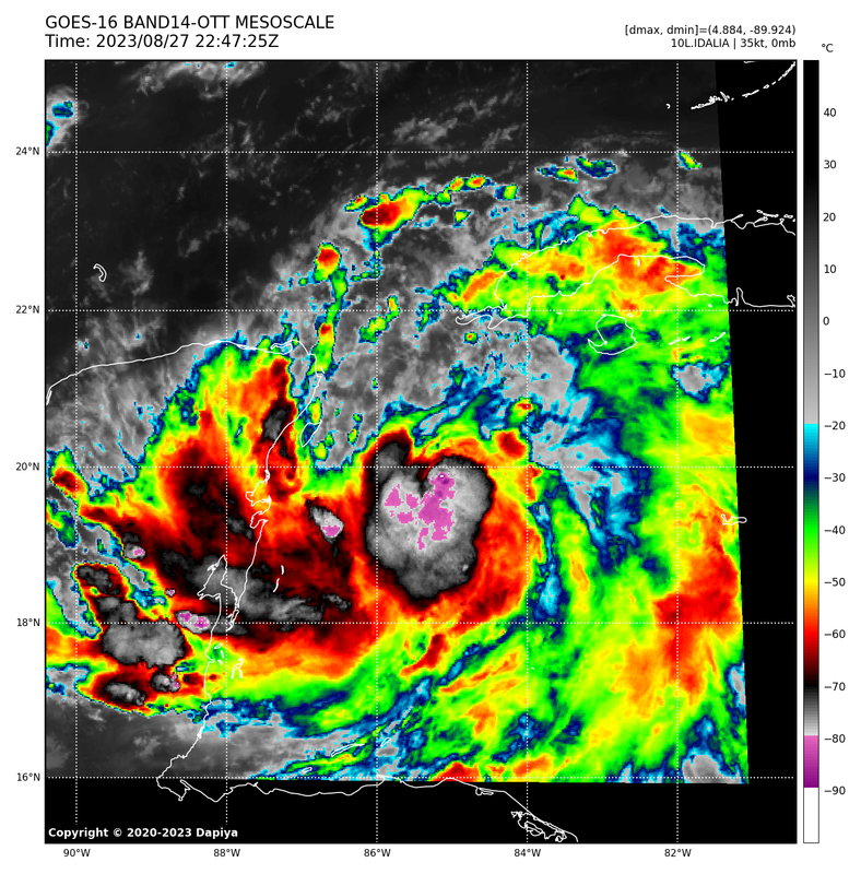
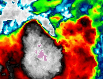
Wow, some of these cloudtops are getting to -90C
3 likes
-
ElectricStorm

- Category 5
- Posts: 5144
- Age: 25
- Joined: Tue Aug 13, 2019 11:23 pm
- Location: Norman, OK
Re: ATL: INVEST 93L -Discussion
cycloneye wrote:ElectricStorm wrote:I'm thinking upper TS, perhaps a Cat 1 out of this, although considering it's the Gulf I wouldn't all that surprised if it tries to ramp up more than that.
Looks like potentially another dangerous I storm...
This is the 5th post of this thread and our friend said it all well as is happening.
Definitely not surprised it's trending towards a stronger storm in the Gulf. We'll have to see if it ends up clipping Cuba or not, which could somewhat limit it for at least a few hours but either way the chances of a major are going up quite a bit.
2 likes
B.S Meteorology, University of Oklahoma '25
Please refer to the NHC, NWS, or SPC for official information.
Please refer to the NHC, NWS, or SPC for official information.
Re: ATL: IDALIA - Tropical Storm - Discussion
Hopefully, once the cyclone emerges into the Gulf, it will move quickly along whatever path it takes, and passes thru all areas with minimal impacts for yall....
Last edited by underthwx on Sun Aug 27, 2023 6:00 pm, edited 1 time in total.
1 likes
-
eastcoastFL

- Category 5
- Posts: 3996
- Age: 44
- Joined: Thu Apr 12, 2007 12:29 pm
- Location: Palm City, FL
Re: ATL: IDALIA - Tropical Storm - Discussion
I don't think we will have a solid idea about track or intensity until it begins its trek north and then north east. A lot of timing and factors in play with the trough. We probably will have a clearer idea late tomorrow night.
1 likes
Personal Forecast Disclaimer:
The posts in this forum are NOT official forecast and should not be used as such. They are just the opinion of the poster and may or may not be backed by sound meteorological data. They are NOT endorsed by any professional institution or storm2k.org. For official information, please refer to the NHC and NWS products.
The posts in this forum are NOT official forecast and should not be used as such. They are just the opinion of the poster and may or may not be backed by sound meteorological data. They are NOT endorsed by any professional institution or storm2k.org. For official information, please refer to the NHC and NWS products.
-
johngaltfla

- Category 5
- Posts: 2073
- Joined: Sun Jul 10, 2005 9:17 pm
- Location: Sarasota County, FL
- Contact:
Re: ATL: INVEST 93L -Discussion
ElectricStorm wrote:cycloneye wrote:ElectricStorm wrote:I'm thinking upper TS, perhaps a Cat 1 out of this, although considering it's the Gulf I wouldn't all that surprised if it tries to ramp up more than that.
Looks like potentially another dangerous I storm...
This is the 5th post of this thread and our friend said it all well as is happening.
Definitely not surprised it's trending towards a stronger storm in the Gulf. We'll have to see if it ends up clipping Cuba or not, which could somewhat limit it for at least a few hours but either way the chances of a major are going up quite a bit.
That part of Cuba is not an inhibiting factor. It is not wide enough to disrupt the flow as the storm moves North.
2 likes
-
cycloneye

- Admin

- Posts: 149319
- Age: 69
- Joined: Thu Oct 10, 2002 10:54 am
- Location: San Juan, Puerto Rico
Re: ATL: INVEST 93L -Discussion
johngaltfla wrote:ElectricStorm wrote:cycloneye wrote:
This is the 5th post of this thread and our friend said it all well as is happening.
Definitely not surprised it's trending towards a stronger storm in the Gulf. We'll have to see if it ends up clipping Cuba or not, which could somewhat limit it for at least a few hours but either way the chances of a major are going up quite a bit.
That part of Cuba is not an inhibiting factor. It is not wide enough to disrupt the flow as the storm moves North.
That area of Pinar del Rio does not have tall mountains and is flat.
2 likes
Visit the Caribbean-Central America Weather Thread where you can find at first post web cams,radars
and observations from Caribbean basin members Click Here
and observations from Caribbean basin members Click Here
-
ElectricStorm
- Category 5
- Posts: 5144
- Age: 25
- Joined: Tue Aug 13, 2019 11:23 pm
- Location: Norman, OK
Re: ATL: INVEST 93L -Discussion
cycloneye wrote:johngaltfla wrote:ElectricStorm wrote:Definitely not surprised it's trending towards a stronger storm in the Gulf. We'll have to see if it ends up clipping Cuba or not, which could somewhat limit it for at least a few hours but either way the chances of a major are going up quite a bit.
That part of Cuba is not an inhibiting factor. It is not wide enough to disrupt the flow as the storm moves North.
That area of Pinar del Rio does not have tall mountains and is flat.
Well that wouldn't hurt it much then. Yeah pretty concerning all the way around now
2 likes
B.S Meteorology, University of Oklahoma '25
Please refer to the NHC, NWS, or SPC for official information.
Please refer to the NHC, NWS, or SPC for official information.
-
ConvergenceZone
.gif)
- Category 5
- Posts: 5241
- Joined: Fri Jul 29, 2005 1:40 am
- Location: Northern California
Re: ATL: IDALIA - Tropical Storm - Discussion
Jr0d wrote:We still may see the center reformation as it's not well defined based on radar and recon data. If this happens it would be most likely be further east...which should shift the forecast more to the right.
My take is a slower with turn east further south, where a faster moving storm will make it further north before the trough gets it to turn northeast.
Dont want to speculate on winds but I will be surprised if this is not a major at landfall. I can hope that it moves fast enough to limit surge.
Radar from Cuba:
http://www.insmet.cu/asp/genesis.asp?TB ... AXw01a.gif
I think a major isn't out of the question if it tracks more north than East. If it tracks more east, then I'll go with a Cat one cane(assuming a Tuesday Night landfall due to a pronounced eastward shift).
4 likes
-
ConvergenceZone
- Category 5
- Posts: 5241
- Joined: Fri Jul 29, 2005 1:40 am
- Location: Northern California
Re: ATL: IDALIA - Tropical Storm - Discussion
Owasso wrote:Wow, some of these cloudtops are getting to -90C
https://i.postimg.cc/3JmkDXRS/7-FED1-A75-D316-40-CA-BF8-D-1-B169236-E602.png
Yea, it's looking much better than this morning's sheared mess.
0 likes
-
Keldeo1997
- Category 2

- Posts: 688
- Joined: Fri Oct 11, 2019 11:35 pm

-
Hypercane_Kyle

- Category 5
- Posts: 3465
- Joined: Sat Mar 07, 2015 7:58 pm
- Location: Cape Canaveral, FL
Re: ATL: IDALIA - Tropical Storm - Discussion
Wouldn't be surprised if this blow up in thunderstorms causes the LLC to start moving even more erratically.

1 likes
My posts are my own personal opinion, defer to the National Hurricane Center (NHC) and other NOAA products for decision making during hurricane season.

-
SconnieCane
- Category 5
- Posts: 1013
- Joined: Thu Aug 02, 2018 5:29 pm
- Location: Madison, WI
Re: ATL: IDALIA - Tropical Storm - Discussion
Should be noted that with the possibility of both an intense MH and a Big Bend landfall strongly on the table; that while the coastal regions of the Big Bend are sparsely populated, what is there is mostly trailers and RV parks and this thing has the potential to carry major hurricane-force winds well inland, as Michael and Ian did. No (or few) post-Andrew building codes at play here.
2 likes
Re: ATL: IDALIA - Tropical Storm - Discussion
Pressure keeps falling on Buoy 42056, now at 998.8mb
2 likes
Who is online
Users browsing this forum: No registered users and 66 guests