ATL: IDALIA - Post-Tropical - Discussion
Moderator: S2k Moderators
Re: ATL: IDALIA - Tropical Storm - Discussion
One thing that I have been noticing with these hurricane models is that the winds aren't quite what you would expect for how low the pressure is once it is in the GOM.
0 likes
-
Keldeo1997
- Category 2

- Posts: 688
- Joined: Fri Oct 11, 2019 11:35 pm
Re: ATL: IDALIA - Tropical Storm - Discussion

Last edited by Keldeo1997 on Sun Aug 27, 2023 6:35 pm, edited 1 time in total.
0 likes

Re: ATL: IDALIA - Tropical Storm - Discussion
IcyTundra wrote:One thing that I have been noticing with these hurricane models is that the winds aren't quite what you would expect for how low the pressure is once it is in the GOM.
They do that a lot, especially the HWRF. I think it’s because the HWRF often predicts EWRCs/eyewall melds and other internal dynamics, which keeps the winds lower than expected for certain pressures. I’ve seen runs of many systems with 940s and 930s pressures than have <100 kt winds because the HWRF is showing concentric eyewalls
2 likes
Irene '11 Sandy '12 Hermine '16 5/15/2018 Derecho Fay '20 Isaias '20 Elsa '21 Henri '21 Ida '21
I am only a meteorology enthusiast who knows a decent amount about tropical cyclones. Look to the professional mets, the NHC, or your local weather office for the best information.
I am only a meteorology enthusiast who knows a decent amount about tropical cyclones. Look to the professional mets, the NHC, or your local weather office for the best information.
-
weeniepatrol

- Category 5

- Posts: 1343
- Joined: Sat Aug 22, 2020 5:30 pm
- Location: WA State

Re: ATL: IDALIA - Tropical Storm - Discussion
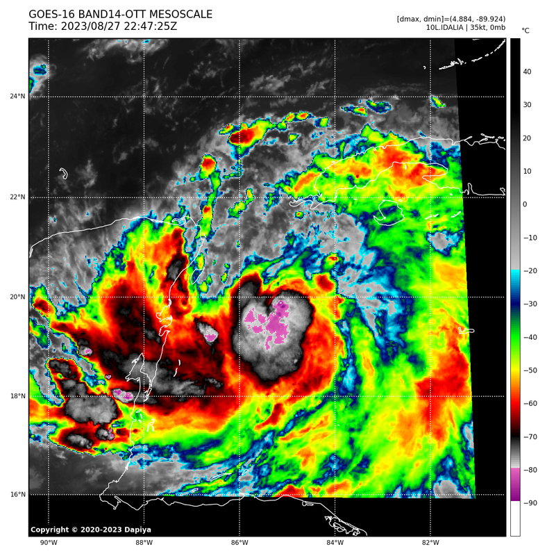
Owasso wrote:Wow, some of these cloudtops are getting to -90C
https://i.postimg.cc/3JmkDXRS/7-FED1-A75-D316-40-CA-BF8-D-1-B169236-E602.png
Kinda reminds you of Wilma right before she exploded! Of course intensity wise won't be like Wilma but just how it looks in the early stages with the small core.
https://www.youtube.com/shorts/wEOM1Y1Jv3o
0 likes


Re: ATL: IDALIA - Tropical Storm - Discussion
Ianswfl wrote:Owasso wrote:Wow, some of these cloudtops are getting to -90C
https://i.postimg.cc/3JmkDXRS/7-FED1-A75-D316-40-CA-BF8-D-1-B169236-E602.png
Kinda reminds you of Wilma right before she exploded! Of course intensity wise won't be like Wilma but just how it looks in the early stages with the small core.
https://www.youtube.com/shorts/wEOM1Y1Jv3o
Like the comparison.
Where you you from?
0 likes
-
MarioProtVI
- Category 5
- Posts: 1034
- Age: 24
- Joined: Sun Sep 29, 2019 7:33 pm
- Location: New Jersey
Re: ATL: IDALIA - Tropical Storm - Discussion
Keldeo1997 wrote:https://pbs.twimg.com/media/F4ky5TzbkAAma2t?format=png&name=small
And there we go. It keeps this up it’ll be matching or exceeding Michael’s intensity it was by its advisory 8 (11am) tomorrow (also 11am at advisory 8).
1 likes
-
weeniepatrol
- Category 5
- Posts: 1343
- Joined: Sat Aug 22, 2020 5:30 pm
- Location: WA State
-
Hurrilurker

- Category 2
- Posts: 738
- Joined: Mon Jun 09, 2003 3:32 pm
- Location: San Francisco, CA
Re: ATL: IDALIA - Tropical Storm - Discussion
Feels dangerous because people are only going to have a couple days to prepare, and then only if they're paying attention, and most probably aren't yet. Due to the track uncertainty and land features, evacuating most of the west coast of Florida in a day or so is a practical impossibility, so I hope it doesn't really blow up because a lot of people are still going to be there, and be unprepared. Add to that tomorrow morning it's Monday so many will have their days taken up at work.
4 likes
Re: ATL: IDALIA - Tropical Storm - Discussion
This thing will start chugging once in the Gulf. Due to the shape of the FL coast, if it takes some jogs to the right, it could catch many by Surprise. Charley would be a better comparison movement wise. There is more chance this goes south than north of forecast track. If it decides to go more east of forecast you could have Bradenton or Tampa landfall instead of a Cedar Key landfall. And it would be late Tue night, too late to really prepare much.I bet Tue afternoon a lot of people in the Tampa area will be watching closely.
0 likes
Re: ATL: IDALIA - Tropical Storm - Discussion
MetroMike wrote:Ianswfl wrote:Owasso wrote:Wow, some of these cloudtops are getting to -90C
https://i.postimg.cc/3JmkDXRS/7-FED1-A75-D316-40-CA-BF8-D-1-B169236-E602.png
Kinda reminds you of Wilma right before she exploded! Of course intensity wise won't be like Wilma but just how it looks in the early stages with the small core.
https://www.youtube.com/shorts/wEOM1Y1Jv3o
Like the comparison.
Where you you from?
Punta Gorda
2 likes

Re: ATL: IDALIA - Tropical Storm - Discussion
Seems like it keeps sliding East. Almost at 85W

0 likes
The following post is NOT an official forecast and should not be used as such. It is just the opinion of the poster and may or may not be backed by sound meteorological data. It is NOT endorsed by any professional institution including storm2k.org For Official Information please refer to the NHC and NWS products.
-
FLLurker32
- Tropical Storm

- Posts: 245
- Joined: Mon Aug 29, 2016 10:31 am
Re: ATL: IDALIA - Tropical Storm - Discussion
It’s important to note that a 40 mile shift east (within the current cone) would bring a potential MH into areas that haven’t experienced more than tropical storm winds in decades. All of these areas from Hernando to Ocala and Gainesville are very populated. Since 2020 the area has grown exponentially with people who are not from Florida. They do not own shutters. Their electric grid is primarily all above ground. Most in these areas do not bother to own generators. The last time anything came through this area of central FL with more than tropical storm winds was in 1960 with Hurricane Donna when it was still very densely populated.
2 likes
Heather
-
TallyTracker
- Category 2
- Posts: 787
- Joined: Thu Oct 11, 2018 2:46 pm
Re: ATL: IDALIA - Tropical Storm - Discussion
That looks like a nascent eyewall forming in the latest radar and satellite pictures. As others have said, likely in the 50 - 60 mph range now and steadily intensifying.
I’ve got all the preps done I can here. Gonna make a decision tomorrow whether to head west and visit family earlier than Labor Day weekend. Don’t want to be in Tallahassee with the tree carnage that may happen. Thinking of what both Hermine and Michael did here.
I’ve got all the preps done I can here. Gonna make a decision tomorrow whether to head west and visit family earlier than Labor Day weekend. Don’t want to be in Tallahassee with the tree carnage that may happen. Thinking of what both Hermine and Michael did here.
1 likes
Fran '96, Georges '98, Gordon '00, Gabrielle '01, Charley '04, Frances '04, Jeanne '04, Barry '07, Fay '08, Debby '12, Matthew '16, Emily '17, Irma '17, Michael ‘18, Elsa ‘21, Fred ‘21, Mindy ‘21, Nicole ‘22, Idalia ‘23, Debby ‘24, Helene ‘24
Re: ATL: IDALIA - Tropical Storm - Discussion
Models are all in pretty agreement which you would expect with about 62 hours out from landfall. For Ian the UKMET and ICON were way out ahead of the other models especially the GFS indicating a landfall in SWFL near Ft Myers, but for Idalia the models are in much better agreement. Some shifts are still possible but I wouldn't expect this to make landfall any further south than Tampa imo.
Last edited by IcyTundra on Sun Aug 27, 2023 6:57 pm, edited 1 time in total.
2 likes

Re: ATL: IDALIA - Tropical Storm - Discussion
The recent bursts have put in a lot of work on radar. Hopefully temporary

0 likes
Re: ATL: IDALIA - Tropical Storm - Discussion
Hard to tell if the LLC is still partially exposed. If not, then there will be a big problem.
0 likes
-
dukeblue219
- S2K Supporter

- Posts: 556
- Joined: Fri Sep 30, 2016 3:52 pm
Re: ATL: IDALIA - Tropical Storm - Discussion
FLLurker32 wrote:It’s important to note that a 40 mile shift east (within the current cone) would bring a potential MH into areas that haven’t experienced more than tropical storm winds in decades. All of these areas from Hernando to Ocala and Gainesville are very populated. Since 2020 the area has grown exponentially with people who are not from Florida. They do not own shutters. Their electric grid is primarily all above ground. Most in these areas do not bother to own generators. The last time anything came through this area of central FL with more than tropical storm winds was in 1960 with Hurricane Donna when it was still very densely populated.
Gainesville is 50 miles inland. It's relatively rare for any hurricane -even major - to record sustained hurricane force winds that far inland even if the advisories say it should. I say that not to discourage anyone from preparing, but to encourage those at the coast to simply move inland even if they feel they can't get out of the state.
0 likes

Re: ATL: IDALIA - Tropical Storm - Discussion
zzzh wrote:Hard to tell if the LLC is still partially exposed. If not, then there will be a big problem.
NHC has the 0z location at 20.1N 85.4W, which is north of the recent rotating towers. That might be a saving grace.
0 likes
TC naming lists: retirements and intensity
Most aggressive Advisory #1's in North Atlantic (cr. kevin for starting the list)
Most aggressive Advisory #1's in North Atlantic (cr. kevin for starting the list)
Re: ATL: IDALIA - Tropical Storm - Discussion
SconnieCane wrote:Should be noted that with the possibility of both an intense MH and a Big Bend landfall strongly on the table; that while the coastal regions of the Big Bend are sparsely populated, what is there is mostly trailers and RV parks and this thing has the potential to carry major hurricane-force winds well inland, as Michael and Ian did. No (or few) post-Andrew building codes at play here.
Yeah that's the issue here south of Perry not far from Gulf. Irma strengthened last 2 hours destroyed the pier and storm surge was awful. 91 gust at airport but most structures did well... trees and powerlines not so well. Michael went 2 hours west and mostly spared us. Seems a 50-50 chance from all ive gleaned that we could get a direct hit (or a few miles either way) as a Cat3 at least. Wish they could say, as it determines if we evacuate (we are 10 miles inland). Any idea (if this occurs) how soon before that landfall event they can forecast that scenario with any strong likelihood? TY
1 likes
Who is online
Users browsing this forum: No registered users and 43 guests